Les boules de grès sont situées sur la commune de BEVONS, lieu-dit "Le Puy", sur une colline vers la côte altimétrique 835 mètres.

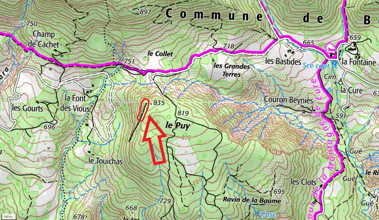
Pour s'en approcher en voiture, de la D946 prendre la D553 pour monter au lieu-dit "la fontaine". De là, suivre la piste du sentier de grande randonnée GR946 vers l'ouest, en passant par "les bastides", "les grandes terres", jusqu'au lieu-dit "le Collet" où vous stationnez votre voiture. L'accès est toléré j'ai rencontré la propriétaire des lieux, mais ne posez pas votre voiture sur un chemin, pour permettre les évolutions de ses engins agricoles.
De là il va falloir marcher un peu, une courte pente un peu raide pour atteindre le sommet de la colline, et se diriger vers la barre rocheuse à l'ouest du sommet. Il faut passer sous un fil de fer cloture à bétail, pour descendre dans les rochers, prenez garde où vous posez les pieds dans la pente, il n'y a pas vraiment de chemin tracé. Dirigez vous aux coordonnées indiquées, vous arrivez sur le site des boules.
Il s'agit de sphéroïdes de nature gréseuse que l'érosion a par places dégagés de leur gangue. Ils sont simplement mieux cimentés que le reste du grès, apparemment plus tendre ou plus altérable, formant le banc qui les héberge. Le processus de formation de ces boules consiste dans le fait que la cimentation (qui a ici transformé le sable en grès) a dû progresser de l'intérieur vers l'extérieur à partir d'un germe central (comme une coquille d'ammonite) Ces boules de grès se sont formées il y a environ 110 miliions d'années, et sont contenues dans l'Albien (dernier étage du Crétacé inférieur) A une époque où la région était sous la mer avant la formation des Alpes, des vases et des boues fines déposées par sédimentation ont formé plus tard le banc de grès devant lequel nous nous trouvons.
Il existe d'autres sites de boules de grès en provence, comme sur la colline "Pierre Avon" entre Sisteron et Bevons, où à Saint-André-de-Rosans (Hautes Alpes) sur une petite colline nommée Serre d'Autruy. Appelées "paramoudras" au pays basque, sur le site de Jaizkibel certaines formations cylindriques cotoient des boules, ce qui fait penser à Michel MOLIA que le départ de la grésification se fait au niveau d'un reste d'organisme fouisseur, comme les vers (ou de leur terrier dans le cas d'un paramoudra cylindrique) Voir son article intéressant sur le lien suivant:
"LES PARAMOUDRAS DU JAIZKIBEL Signes et hypothèses de formation"
Pour valider cette cache, vous devez répondre aux questions suivantes :
Question 1: Dans quelle ère se sont formées les boules de grès?
Question 2: Voyez vous des fossiles dans les boules? Si oui décrivez les.
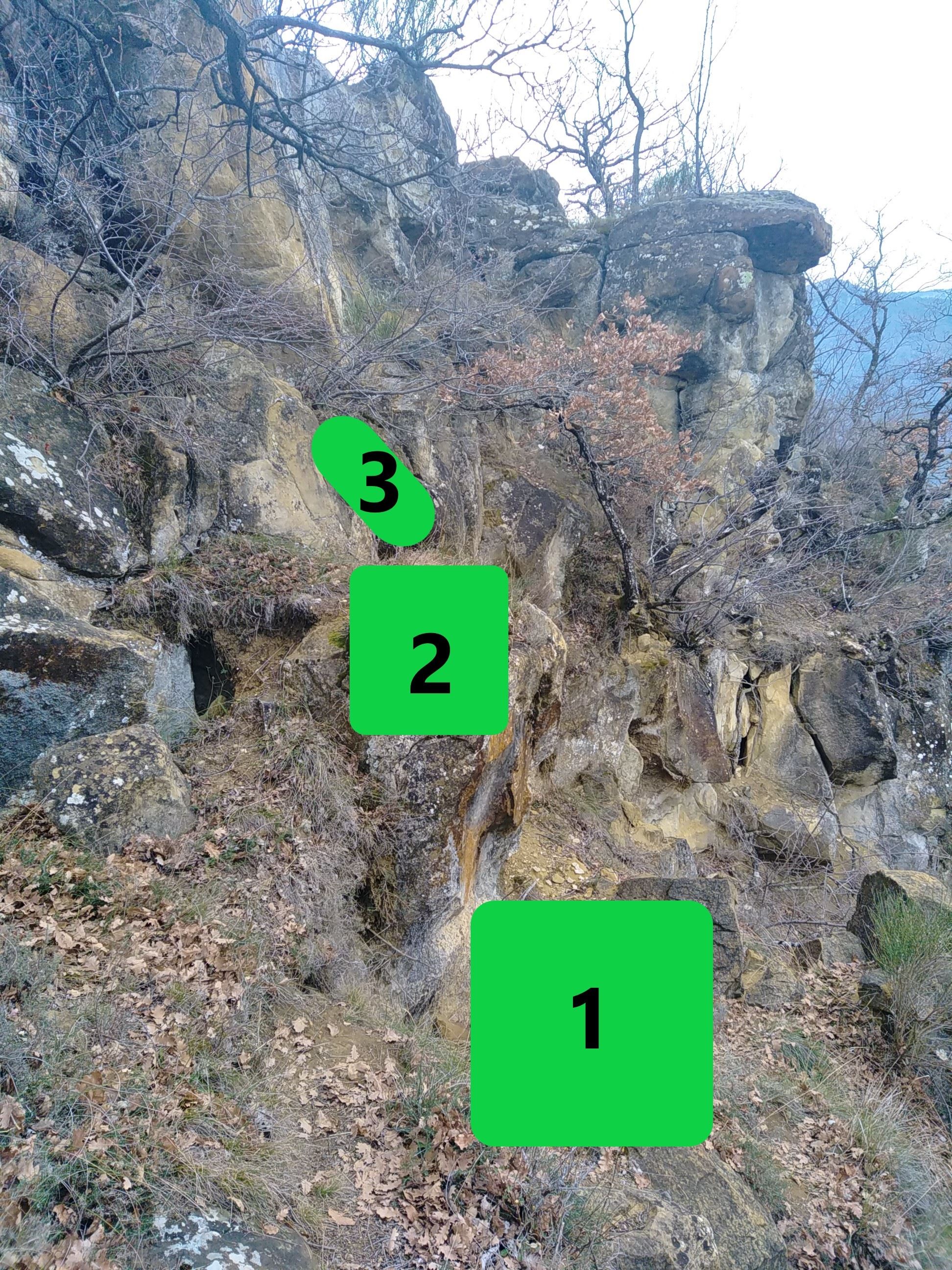
Question 3: Sur la photo des zones vertes numérotées, classez les dans l'ordre chronologique de leur évolution, et expliquez pourquoi. Pour vous orienter dans le paysage remarquez le gros rocher en surplomb à l'arrière plan de la photo.
Question 4: Prenez une photo de vous ou de votre GPS avec le rocher en surplomb en arrière plan, sans montrer les "cases" 1-2-3.
Loguez la cache en "Found it" avec votre photo et envoyez-moi vos propositions de réponses soit via mon profil, soit via la messagerie geocaching.com (Message Center). Je vous contacterai en cas de problème.
The sandstone balls are located in the town of BEVONS, a place called "Le Puy", on a hill towards the altimetric coast 835 meters.
To approach it by car, from the D946 take the D553 to go up to a place called "la fontaine". From there, follow the track of the GR946 long-distance hiking trail to the west, passing through "Les bastides", "Les grandes terres", to the place called "le Collet" where you park your car. Access is tolerated I met the owner of the premises, but do not put your car on a path, to allow the evolution of its agricultural machinery.

From there you will have to walk a little, a short steep slope to reach the top of the hill, and head towards the rocky bar to the west of the summit. You have to pass under a wire cattle fence, to descend into the rocks, be careful where you put your feet on the slope, there is not really a marked path. Go to the coordinates indicated, you arrive on the site of the balls.

These are sandstone spheroids that erosion has in places freed from their gangue. They are simply better cemented than the rest of the sandstone, apparently softer or more weatherable, forming the bed that hosts them. The process of forming these balls consists in the fact that the cementation (which here transformed the sand into sandstone) had to progress from the inside outwards from a central germ (like an ammonite shell) These sandstone balls were formed about 110 million years ago, and are contained in the Albian (last stage of the lower Cretaceous) At a time when the region was under the sea before the formation of the Alps, the muds and fine mud deposited by sedimentation later formed the sandstone bench in front of which we find ourselves.

There are other sandstone ball sites in Provence, such as on the "Pierre Avon" hill between Sisteron and Bevons, or in Saint-André-de-Rosans (Hautes Alpes) on a small hill called Serre d'Autruy. Called "paramoudras" in the Basque country, on the site of Jaizkibel certain cylindrical formations rub shoulders with balls, which makes Michel MOLIA think that the start of the gresification is done at the level of a remnant of burrowing organism, such as worms ( or their burrow in the case of a cylindrical paramudra) See his interesting article at the following link:
LES PARAMOUDRAS DU JAIZKIBEL
To validate this cache, you must answer the following questions:

Question 1: In what era were the sandstone balls formed?

Question 2: Do you see fossils in the balls? If yes, describe them.

Question 3: On the photo of the numbered green zones, classify them in chronological order of their evolution, and explain why. To orient yourself in the landscape, notice the large overhanging rock in the background of the photo.

Question 4: Take a photo of yourself or your GPS with the overhanging rock in the background, without showing the "boxes" 1-2-3.
Log the cache in "Found it" with your photo and send me your proposed answers either via my profile or via geocaching.com messaging (Message Center). I will contact you if there is a problem.