🇫🇷 👻 Le Puy de Sancy 👻
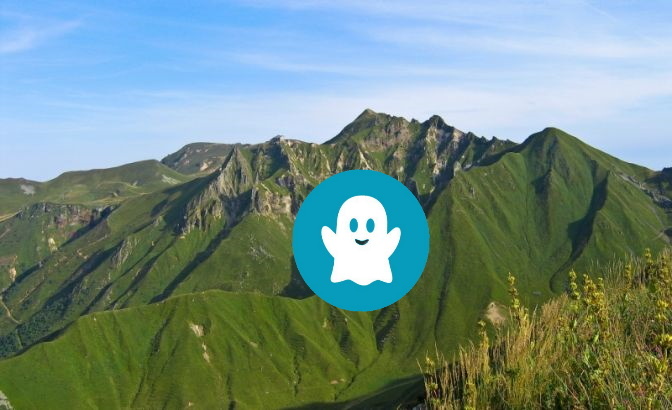
C'est le point culminant du Massif Central avec ces 1886 mètres d’altitude. Il appartient au massif des Monts Dore.
C’est aussi le plus haut sommet français d’origine volcanique.
Au sommet, une vue à 360 degrés sur les lacs et le parc naturel régional des volcans d'Auvergne avec ses vallées glaciaires et ses crêtes. Un panorama incroyable qui récompense largement l’effort de la montée, puisqu’il permet de voir à ses pieds avec une météo favorable, près d’1/7ème du territoire de la France !
La Dore et la Dogne s’y rencontrent et forment la Dordogne qui débute sa longue course jusqu’en Gironde.
Accès au site depuis le parking du Puy de Sancy (WP1)
– le plus facile : par le téléphérique, après la montée, un escalier de bois (864 marches), vous permet d’accéder au sommet en 20 minutes. Vous y trouverez une table d’orientation et de lecture de paysage.
– à pied : comptez environ 3 h de marche (boucle de 7 km – 546 m de dénivelé).
– combiné : un trajet en téléphérique et une montée ou descente à pied (1h30)
Le parc naturel régional des volcans d'Auvergne regroupe 80 volcans, inscrits au Patrimoine Mondial de l’UNESCO. C'est un véritable paradis de la randonnée et des amoureux de la nature.
=-=-=-=-=-=-=-=-=-=-=-=-=-=
POUR VALIDER CETTE VIRTUELLE:
- Rendez vous au sommet du Puy de Sancy et plus précisément au niveau de la table d'orientation.
1) Côté Ouest,quel est le nom du lieu situé entre La Tour d'Auvergne et la station Chastreix-Sancy? La réponse à cette question est à m'envoyer par messagerie ou par la messagerie du site.
2) Joindre à votre Log une photo de vous (montrer son visage est facultatif) ou de votre pseudo géocaching (pas de nom de TEAM) inscrit sur n'importe quel support qui vous fera plaisir avec OBLIGATOIREMENT la gare du téléphérique derrière vous.
C'est une Virtuelle qui se mérite donc tous les logs dont je n'aurais pas reçu de réponse à la question où dont les photos ne correspondent pas à ma demande (photo prise du parking ou de la gare du téléphérique par exemple) seront purement et simplement supprimés.
Virtual Rewards 3.0 - 2022-2023
Cette cache virtuelle fait partie d'une version limitée de Virtuals créée entre le 1er mars 2022 et le 1er mars 2023. Seuls 4 000 propriétaires de cache ont eu la possibilité de cacher une cache virtuelle. En savoir plus sur Virtual Rewards 3.0 sur le blog Geocaching.
XXXXXXXXXXXXXXX
🇬🇧 👻 The Puy-de-Sancy 👻

It is the highest point of the Massif Central with these 1886 meters of altitude. It belongs to the Monts Dore massif.
It is also the highest French summit of volcanic origin.
At the top, a 360 degree view of the lakes and the Auvergne Volcanoes Regional Natural Park with its glacial valleys and ridges. An incredible panorama which largely rewards the effort of the climb, since it allows you to see at your feet with favorable weather, nearly 1/7th of the territory of France!
The Dore and the Dogne meet there and form the Dordogne which begins its long course to Gironde.
Access to the site from the Puy de Sancy car park (WP1)
– the easiest: by cable car, after the climb, a wooden staircase (864 steps), allows you to reach the summit in 20 minutes. You will find an orientation and landscape reading table.
– on foot: count about 3 hours of walking (loop of 7 km – 546 m of elevation).
– combined: a trip by cable car and an ascent or descent on foot (1h30)
The Auvergne Volcanoes Regional Natural Park brings together 80 volcanoes, listed as UNESCO World Heritage Sites. It is a real paradise for hikers and nature lovers.
=-=-=-=-=-=-=-=-=-=-=-=-=-=
TO VALIDATE THIS VIRTUAL:
- Meet at the top of Puy de Sancy and more precisely at the orientation table.
1) West side, what is the name of the place located between La Tour d'Auvergne and Chastreix-Sancy station? The answer to this question is to be sent to me by e-mail or by the e-mail of the site.
2) Attach to your log a photo of you (showing your face is optional) or your pseudo geocaching ( no TEAM name) on any medium that will make you happy with OBLIGATORILY, the cable car station behind you.
It is a Virtual which deserves therefore all the logs of which I would not have received an answer to the question or whose photos do not correspond to my request (photo taken from the car park or the cable car station for example) will be deleted.
=-=-=-=-=-=-=-=-=-=-=-=-=-=
Virtual Rewards 3.0 - 2022-2023
This Virtual Cache is part of a limited release of Virtuals created between March 1, 2022 and March 1, 2023. Only 4,000 cache owners were given the opportunity to hide a Virtual Cache. Learn more about Virtual Rewards 3.0 on the Geocaching Blog.