[SK]: Gerlachovský štít (hovorovo Gerlach, 2654,4 m n. m.) je najvyšších vrchom nielen Vysokých Tatier, ale aj celého horského masívu Karpát. Nachádza sa mimo hlavného hrebeňa v strednej z piatich hlavných bočných rázsoch smerujúcich na juh. Z vrcholu pokračuje tento hrebeň na Kotlový štít (2601 m n. m.), kde sa rozvidluje na dve ramená a vytvára známy Gerlachovský kotol. Názov štítu je odvodený od obce Gerlachov, ktorej katastrálne územie siahlo až do týchto častí Vysokých Tatier. Viac informácií o Gerlachovskom štíte nájdeš napr. tu.
POZOR! Táto virtuálna keška je prístupná, len ak dodržíte zákonom stanovené podmienky! Keška je umiestnená na území Tatranského národného parku mimo vyznačený turistický chodník, preto je návštevníkom prístupná len v sprievode oprávnenej osoby (horského vodcu) a horolezcom organizovaným v horolezeckých zväzoch. Najpopulárnejší turistický výstup je zo Sliezskeho domu, odkiaľ pre väčšiu bezpečnosť sprevádzajú horskí vodcovia turistov na vrchol jednosmerne: vystupuje sa Velickou próbou a zostupuje sa Batizovskou próbou (ktorá sa výnimočne používa aj na výstup).
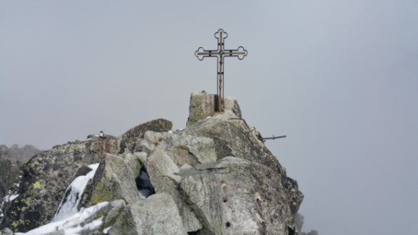
Pre uznanie logu tejto virtuálnej kešky je potrebné absolvovať výstup na Gerlachovský štít. Výstup dokladuj vrcholovou fotografiou, odfoť seba (alebo len svoju ruku s osobným predmetom, xWG, alebo papierom, na ktorom je napísaný tvoj nick) pri kríži s prstami na ruke v tvare "V" – viď vzorovú fotku. Do logu prosím pripoj túto povinnú fotografiu, prípadne dobrovoľne aj ďalšie. Logy bez povinnej fotografie budú vymazané bez upozornenia.
V období zimnej uzávery, od 1. novembra až do 15. júna je táto virtuálna keška dočasne nedostupná! Prosím o rešpektovanie nariadenia TANAP-u! Prajem veľa príjemných zážitkov počas výstupu na najvyšší vrch karpatského oblúku.
[EN]: Gerlachovský štít (informally referred to as Gerlach, 2654.4 m amsl) is the highest peak not only of the High Tatras, but also of the entire Carpathian massif. It is located off the High Tatras' main ridge, in the middle of the five main south-facing spurs. From the top, this ridge continues to Kotlový štít (2601 m amsl), where it forks into two arms and forms the famous Gerlachovský kotol. The name of the peak is derived from the village of Gerlachov, whose cadastral territory extended to these parts of the High Tatras. You can find more information about Gerlachovský štít here.
WARNING! This virtual cache is only accessible if you comply with the legal conditions! Cache is placed in Tatra National Park, off the official marked hiking paths, and therefore is accessible only for visitors accompanied by an authorized person (mountain guide) and for climbing and mountaineering federation members. The most popular ascent route starts from Sliezsky dom Mountain Hotel, from where, for greater safety, mountain guides accompany tourists to the top in one direction: the ascent is via Velická próba and the descent is via Batizovská próba (which is also exceptionally used for ascent).
To claim this virtual cache, it is necessary to climb Gerlachovský štít. Document your visit with a photo on the top, take a photo of yourself (or just your hand with a personal object, xWG, or a paper with your nickname written on it) near the cross and with fingers on the hand in the shape of a "V" – see sample photo. Please attach the mandatory photo, or optionally another ones to your log. Logs without this mandatory photo will be deleted without a notice.
During the winter closure period, from November 1st to June 15th, this virtual cache is temporarily unavailable! Please respect the TANAP regulation! I wish you many pleasant experiences during your hike to the highest peak of the Carpathians.
This Virtual Cache is part of a limited release of Virtuals created between March 1, 2022 and March 1, 2023. Only 4,000 cache owners were given the opportunity to hide a Virtual Cache. Learn more about Virtual Rewards 3.0 on the Geocaching Blog.