Il s'agit d'une Earthcache, il n'y a pas de récipient à chercher.
Pont Rouge à Marcillac
Marcillac est une ville implantée dans une vallée dégagée dans le permien rouge. Il est le centre d’occupations humaines très anciennes attestées par une pointe moustérienne (vers -50 000 ans) trouvée près d’ossements de bisons dans la vallée de l’Ady, et un biface paléolithique près de Cadayrac. Au centre d’un grand foyer mégalithique qui groupe une vingtaine d’exemplaires de dolmens, le vallon de Marcillac recèle aussi des sépultures de l’âge du bronze, des sépultures de l’âge du fer, et un atelier métallurgique accompagné de mobilier du 1er siècle. Issu d’un prieuré de l’abbaye de Conques, le bourg est entièrement bâti en grès rouge du permien. La richesse du bourg provenait de la proximité de domaines viticoles.

Entre les profondes entailles des vallées du Cruou au sud et du Dourdou au nord, la crête du Grand Mas forme une longue arête d’orientation est-ouest de calcaires et de marnes du lias inférieur, plaqués sur les grès rouges du permien. Près de Gipoulou, comme partout sur la bordure nord des petits causses, on observe, au dessus des grès rouges du permien, le niveau de grès blanc surmontés de marnes grises à traces de racines qui représentent un sol de mangrove établi sur une vaste surface marécageuse. Un peu de gypse dispersé dans les marnes confirme le caractère lagunaire de ces dépôts qui marquent la transition entre le régime continental des grès permiens et le régime marin du lias supérieur.
Grès rouge du permien
Le permien rouge (rougier) est le passage aux premières assises marneuses et dolomitiques du lias inférieur. Le permien représente un dépôt de sédiments détritiques, souvent grossiers, dans une vaste dépression continentale. Le lias inférieur qui lui fait suite et le recouvre marque l’arrivée dans le « détroit de Rodez » d’une invasion marine au rivage lagunaire (marnes et grès blancs), submergé ensuite par une mer peu profonde (calcaires et dolomies).

Les grès rouges ont été abondamment utilisés pour les constructions, en raison de leur grande facilité de taille en moellons parfaitement équarrissables et des bourgades entières sont caractérisées par l’architecture aux murs parfaitement dressés qu’ils permettent : Villecomtal, Marcillac, Saint Cyprien entre autres sur le Dourdou. Mais leur manque de cohésion, due à la présence de fines particules argileuses, entraîne souvent leur corrosion rapide. Cette corrosion est parfaitement observable sur le parement extérieur du Pont Rouge à Marcillac.
Sources
Wikipedia
Mignon, René : Géologie et Patrimoine du Rouergue
Natura-sciences.com
https://planet-terre.ens-lyon.fr/
Questions pour valider cette Earthcache :
- Quelle est la roche dans laquelle sont taillés les moellons du Pont Rouge ?
- C’est une roche magmatique, sédimentaire ou métamorphique ?
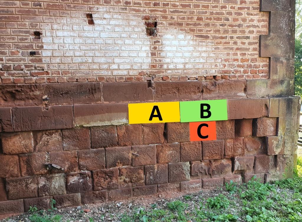
- Repérez les trois zones floutés A, B et C du Pont Rouge. Classez les moellons du moins au plus érodé.
- Touchez les trois zones avec vos doigts. Laquelle contient le plus de particules argileuses ? Pourquoi ?
- Une photo de vous ou d’un objet vous représentant sur le site.

Loguez cette cache "Found it" et envoyez-moi vos propositions de réponses soit via mon profil, soit via la messagerie geocaching.com (Message Center), et je vous contacterai en cas de problème. Les logs enregistrés sans réponses seront supprimés.
English version
This is an Earthcache, there is no container to look for.
Red Bridge in Marcillac
Marcillac is a town located in an open valley in the red Permian. It is the center of very ancient human occupation attested by a Mousterian tip (around -50,000 years ago) found near bison bones in the Ady valley, and a Paleolithic biface near Cadayrac. At the center of a large megalithic hearth which groups around twenty examples of dolmens, the Marcillac valley also conceals Bronze Age burials, Iron Age burials, and a metallurgical workshop accompanied by furniture from the 1st century. Coming from a priory of the abbey of Conques, the village is entirely built in red Permian sandstone. The wealth of the town came from the proximity of wine estates.
Between the deep notches of the Cruou valleys in the south and the Dourdou valleys in the north, the crest of the Grand Mas forms a long east-west ridge of limestone and marl from the lower Lias, flattened against the red sandstone of the Permian. Near Gipoulou, as everywhere on the northern border of the small causses, we observe, above the red sandstones of the Permian, the level of white sandstone surmounted by gray marls with traces of roots which represent a mangrove soil established on a vast marshy surface. . A little gypsum dispersed in the marls confirms the lagoonal character of these deposits which mark the transition between the continental regime of the Permian sandstones and the marine regime of the Upper Lias.
Red Permian sandstone
The red Permian (rougier) is the transition to the first marly and dolomitic layers of the lower lias. The Permian represents a deposit of detrital sediments, often coarse, in a vast continental depression. The lower lias which follows and covers it marks the arrival in the "Strait of Rodez" of a marine invasion on the lagoon shore (marl and white sandstone), then submerged by a shallow sea (limestone and dolomites).
Red sandstones have been widely used for constructions, because of their great ease of cutting into perfectly squared rubble stones and entire villages are characterized by the architecture with perfectly erected walls that they allow: Villecomtal, Marcillac, Saint Cyprien among others on the Dourdou. But their lack of cohesion, due to the presence of fine clay particles, often leads to their rapid corrosion. This corrosion is perfectly observable on the exterior facing of the Pont Rouge in Marcillac.
Questions to validate this Earthcache:
1. What is the rock in which the rubble stones of the Pont Rouge are cut?
2. Is it an igneous, sedimentary or metamorphic rock?
3. Locate the three blurred areas A, B and C of the Red Bridge. Rank the rubble from least to most eroded.
4. Touch the three areas with your fingers. Which contains the most clay particles? Why ?
5. A photo of you or an object representing you on the site.
Log this "Found it" cache and send me your suggested answers either via my profile or via geocaching.com (Message Center), and I will contact you in the event of a problem. Logs recorded without response will be deleted.