Attention, cette Earthcache est accessible à marée basse. Horaires des marées sont ici. Pour y accèder suivez le chemin avec le point de passage.
Vous vous engagez de votre propre initiative dans la recherche de cette cache à vos risques et périls. Je décline donc toute responsabilité en cas de problème.
Il s'agit d'une Earthcache, il n'y a pas de récipient à chercher.
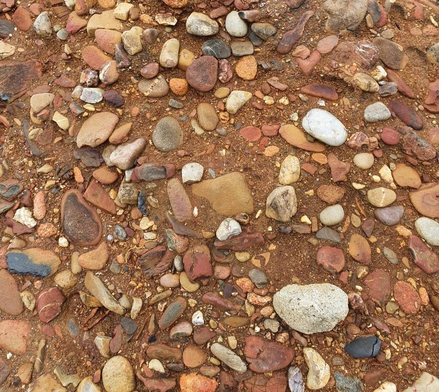
Plage rousse à Porzh Koubou
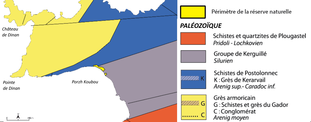
Carte
C’est l’une des plus grandes plages anciennes de Bretagne. La plage fossile, dite plage rousse, est située au-dessus du niveau de la plage actuelle, elle est formée par un conglomérat à galets de nature variée, cimentés par une matrice ferrugineuse (rouge). Elle témoigne d’un haut niveau marin survenu lors d’une période de réchauffement du climat. C’est la première « plage rousse » décrite dans le Massif armoricain (Barrois, 1877), elle confère au site un intérêt patrimonial national.
Plage ancienne
L’anse de Porzh Koubou est creusée dans des schistes et des grès de 425 millions d’années, visibles en falaise et sur le platier rocheux à marée basse. Leur forte inclinaison résulte des plissements de l’écorce terrestre formés lors de la rencontre de plaques continentales.
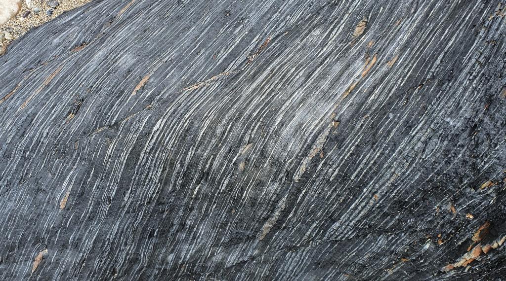
Schistes et grès de Kerguillé
L’accumulation de galets repose en discordance sur ce platier rocheux formé de couches sub-verticales de schistes et de grès appartenant au Groupe de Kerguillé (Silurien). La plage fossile présente en réalité deux niveaux distincts : le premier, sur l’estran et atteignant le pied de la falaise rocheuse, correspond à un conglomérat à galets de nature variée et blocs de schistes dans une matrice sableuse à oxydes de fer. Au-dessus, un second niveau de galets rubéfié et mal consolidé est recouvert en falaise par une épaisse séquence continentale correspondant à des sédiments fins limoneux à blocs et cailloutis (dépôts de solifluxion), présentant à la base des niveaux argileux de teinte grise et un sable dunaire. Les coulées de boue consolidées, surmontant la plage fossile, se sont déposées vers la fin de la dernière glaciation. Charriant des blocs préalablement fracturés par le gel, elles ont glissé le long des pentes lorsque les sols ont dégelé.
Enfin en haut de plage et adossé au pied de falaise actuel, un troisième niveau de galets lessivés, essentiellement de Grès armoricain, correspond au cordon littoral actuel. Les galets de la plage actuelle proviennent principalement de l’érosion de la pointe de Dinan. Autrefois exploités pour l’empierrement des chemins et les constructions, ils sont désormais protégés. Leur utilité est sur la plage, où ils constituent un rempart naturel contre les vagues et un milieu de vie pour certaines plantes et animaux.
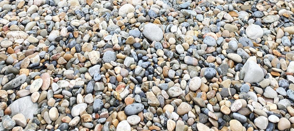
Galets de Grès Armoricain de la plage actuelle
La plage ancienne est difficile à dater en raison de l’absence de fossiles marins ou continentaux. Des méthodes de datation basées sur le rayonnement émis par tout corps minéral enfoui, (la quantité de rayonnement variant avec le temps d’enfouissement), ont été appliquées au niveau consolidé et permettent de proposer un âge Miocène (environ 7 millions d’années) pour la mise en place de ce premier conglomérat.
L’analyse des grains de pollen conservés dans les niveaux argileux gris de la séquence continentale (pin, épicéa et herbacées) témoigne d’une végétation comparable à celle de la fin d’un interglaciaire. Ceci permet de supposer un âge correspondant au dernier interglaciaire, ou à un interglaciaire quaternaire plus ancien, pour le second niveau de galets non consolidé.
Sources
Wikipédia
https://www.reservepresquiledecrozon.bzh/
https://geopark.pnr-armorique.fr/
Sites géologiques de la Presqu’île de Crozon
Géodiversité.net
Vidal, Muriel et coll., 2019, Géotourisme en Presqu’île de Crozon, Éditions SGMB
Questions pour valider cette Earthcache :
- Décrivez et identifiez les roches des zones A, B, C et D.
- Comparez les sédiments de la zone C et D. Quelle est leur forme ? Qu’en déduisez-vous par rapport à leur transport ?
- Comparez la nature des galets dans les zones A et D. Comment expliquez-vous cette différence ?
- Essayez de prendre un galet de la plage fossile, y arrivez-vous ? Pourquoi ?
- Une photo de vous ou d’un objet vous représentant sur le site.
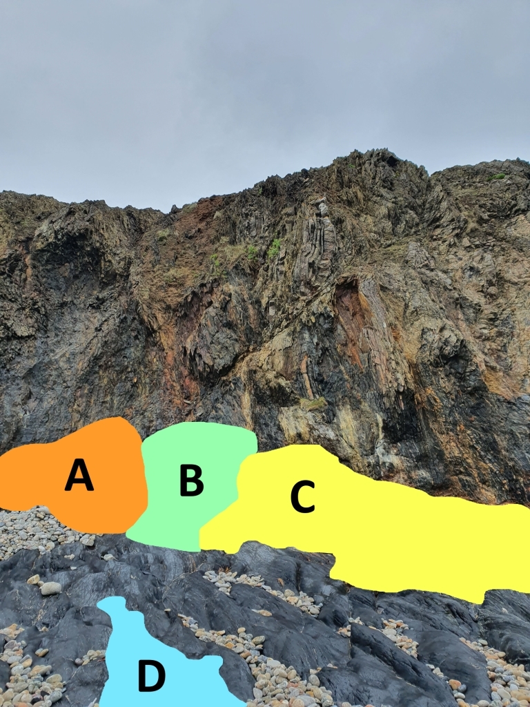
Photo 1
Loguez cette cache "Found it" et envoyez-moi vos propositions de réponses soit via mon profil, soit via la messagerie geocaching.com (Message Center), et je vous contacterai en cas de problème. Les logs enregistrés sans réponses seront supprimés.
English version
Please note, the Earthcache is accessible at low tide. Tide times are here. To acces follow the trailhead.
You engage in the search for this cache on your own initiative at your own risk. I therefore decline all responsibility in the event of a problem.
This is an Earthcache, there is no container to look for.
Red beach in Porzh Koubou
It is one of the largest old beaches in Brittany. The fossil beach, known as the red beach, is located above the level of the current beach, it is formed by a conglomerate with pebbles of varied nature, cemented by a ferruginous matrix (red). It testifies to a high sea level that occurred during a period of global warming. Fit is a first "red beach" described in the Armorican Massif (Barrois, 1877), it gives the site a national heritage interest.
The cove of Porzh Koubou is dug in shales and sandstones of 425 million years, visible in cliff and on the rocky flat at low tide. Their strong inclination results from the folds of the earth's crust formed when continental plates meet.
The accumulation of pebbles rests unconformably on this rocky flat formed by sub-vertical layers of shales and sandstones belonging to the Kerguillé Group (Silurian). The fossil beach has actually two distinct levels: the first, on the foreshore and reaching the foot of the rocky cliff, corresponds to a conglomerate with pebbles of varied nature and blocks of shale in a sandy matrix with iron oxides. Above, a second level of reddened and poorly consolidated pebbles is covered on the cliff by a thick continental sequence corresponding to fine loamy sediments with blocks and pebbles (solifluction deposits), presenting at the base gray clay levels and a dune sand. Consolidated mudslides overlying the fossil beach were deposited towards the end of the last glaciation. Carrying blocks previously fractured by frost, they slid down the slopes when the ground thawed.
Finally at the top of the beach and leaning against the foot of the current cliff, a third level of leached pebbles, mainly Armorican sandstone, corresponds to the current coastal strip. The pebbles of the current beach come mainly from the erosion of the tip of Dinan. Formerly exploited for the stoning of paths and constructions, they are now protected. Their usefulness is on the beach, where they provide a natural barrier against the waves and a living environment for certain plants and animals.
The ancient beach is difficult to date due to the lack of marine or continental fossils. Dating methods based on the radiation emitted by any buried mineral body, (the amount of radiation varying with the time of burial), have been applied at the consolidated level and make it possible to propose a Miocene age (about 7 million years) for the establishment of this first conglomerate.
The analysis of pollen grains preserved in the gray clay levels of the continental sequence (pine, spruce and herbaceous) shows vegetation comparable to that of the end of an interglacial. This makes it possible to assume an age corresponding to the last interglacial, or to an older Quaternary interglacial, for the second level of unconsolidated pebbles.
Questions to validate this Earthcache:
- Describe and identify the rocks in zones A, B, C and D.
- Compare the sediments of zone C and D. What is their shape? What do you deduce from this in relation to their transport?
- Compare the nature of the pebbles in zones A and D. How do you explain this difference?
- Try to take a pebble from the fossil beach, can you do it? Why ?
- A photo of you or an object representing you on the site.

Photo 1
Log this "Found it" cache and send me your suggested answers either via my profile or via geocaching.com (Message Center), and I will contact you in the event of a problem. Logs recorded without response will be deleted.