
La Earthcache / The Earthcache
► Contexte géologique local
Dans la région de Blois, la rive gauche de la Loire voit jaillir au delà de sa zone alluviale un vaste côteau surmonté par le plateau de Russy, culminant à 143 m.
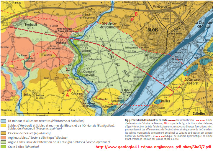
Cette formation géologique est le fruit de la rencontre entre un vaste anticlinal et la puissante Loire.
► L'anticlinal d’Herbault
D’axe WNW-ESE, cette déformation correspond à un flambage de la couverture sédimentaire du Bassin parisien engendrée par la compression pyrénéenne pendant l’Éocène.
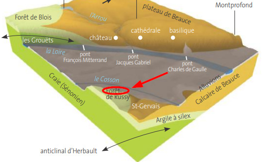
Ce vaste anticlinal, centré sur la forêt de Blois (rive droite de la Loire) a subit les assauts de l'érosion fluvial par la Loire.
Cette incision fluviale débutée au Pléistocène (- 1 Ma) a mis à nu trois formations sédimentaires dans le cadre d'un imposant côteau.
► Les Formations en présence
~ Formation basale : Craie à silex de Blois
Au Sénonien, une transgression marine a entrainé une phase de dépôts marins dont la diagenèse a formé une roche riche en Carbonate de Calcium (CaCO3) avec des nodules de silex.
La craie est une roche blanche, tendre (se raie avec une lame de métal) et friable.
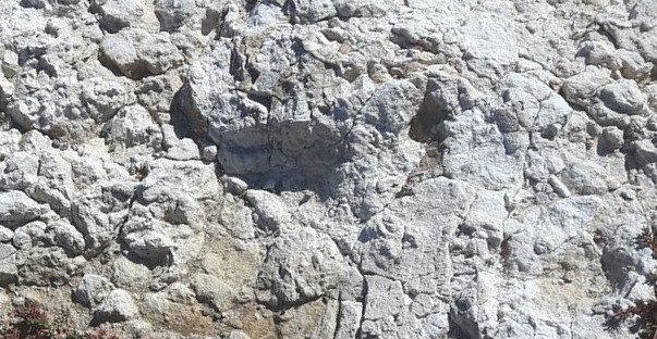
Les silex sont dispersés en nodules de formes irrégulières (rognons,...).
C'est une roche très dure, résistante aux acides et avec une cassure esquilleuse à éclats tranchants.
Par infiltration des eaux météoritiques, la partie supérieure de cette formation calcaire a subit un phénomène de décarbonatation donnant une formation d'altération, l'argile à silex.
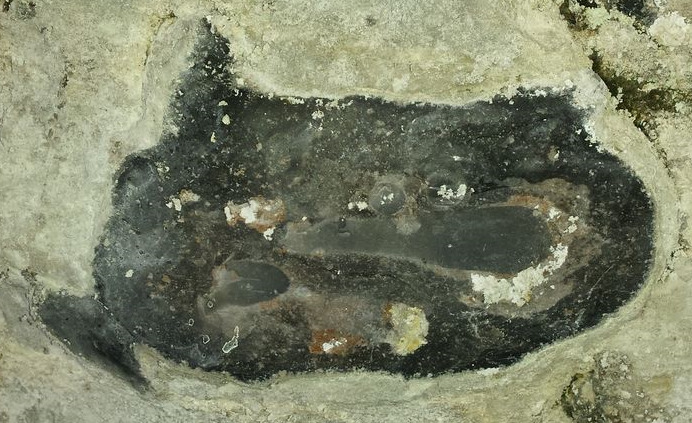
~ Formation intermédiaire : Argile à Silex
L’argile à silex est un produit d’altération de la craie à silex sous-jacente.
Elle a commencé sa mise en place dès la fin de transgression marine sous l'influence des facteurs d'altération continentaux (eau météoritique...).
Au contact de l'eau de pluie acidifiée par le CO2, le CaCO3 s'est dissout en HCO3-, ions en solution lixiviés par ces eaux souterraines.
Au fur et à mesure de cette étape de décarbonatation, il ne reste que deux éléments :
- une argile blanchâtre à gris verdâtre, reste des impuretés présentes dans la craie.
Les argiles sont des sédiments très fins (invisibles à l'œil) avec un aspect plastique et collant.
- les rognons de silex, très durs et insensibles à l'eau acidifié et présentant une cassure esquilleuse, une surface lisse et une couleur dépendant du milieu oxydant ou réducteur de sa formation (plus le silex est sombre, plus le milieu était réducteur).
~ Formation sommitale : Marnes et Sables du Blésois
Cette formation constitue le soubassement de la forêt de Russy. Son épaisseur est peu importante (environ 5 m, jusqu'à 8 m très localement).
Il s'agit d'anciens dépôts détritiques fluviatiles.
Les sables sont constitués de grains de quartz, de feldspaths altérés, de grains calcaires et de quelques morceaux de silex à patine noire. Ce sont des éléments grossiers, de taille millimétrique bien visible à l'œil nu.
► Local geological and topographical context
In the region of Blois, the left bank of the Loire sees springing beyond its alluvial zone a vast hill surmounted by the plateau of Russy, culminating at 143 m.
This geological formation is the result of the encounter between a vast anticline and the mighty Loire.
► The Herbault anticline
With a WNW-ESE axis, this deformation corresponds to a buckling of the sedimentary cover of the Paris Basin generated by the Pyrenean compression during the Eocene.
This vast anticline, centered on the forest of Blois (right bank of the Loire) has suffered the onslaught of fluvial erosion by the Loire.
This fluvial incision started in the Pleistocene (- 1 Ma) exposed three sedimentary formations within the framework of an imposing hillside.
► The Formations in attendance
~ Basal formation: Blois flint chalk
In the Senonian, a marine transgression led to a phase of marine deposits whose diagenesis formed a rock rich in Calcium Carbonate (CaCO3) with nodules of flint.
Chalk is a white rock, soft (can be scratched with a metal blade) and friable.
The flints are scattered in nodules of irregular shapes (kidneys, etc.).
It is a very hard rock, resistant to acids and with a scarring fracture with sharp splinters.
By infiltration of meteoritic waters, the upper part of this limestone formation has undergone a phenomenon of decarbonation giving an alteration formation, clay with flint.
~ Intermediate formation: Clay to Flint
Flint clay is an weathering product of the underlying flint chalk.
It began to be put in place as soon as the marine transgression ended under the influence of continental weathering factors (meteoritic water, etc.).
In contact with rainwater acidified by CO2, the CaCO3 dissolved into HCO3-, ions in solution leached by these underground waters.
As this decarbonation step progresses, only two elements remain:
- a whitish to greenish gray clay, remains of the impurities present in the chalk.
Clays are very fine sediments (invisible to the eye) with a plastic and sticky appearance.
- flint kidneys, very hard and insensitive to acidified water and presenting a scarring break, a smooth surface and a color depending on the oxidizing or reducing medium of its formation (the darker the flint, the more the medium was reducing).
~ Summit formation: Marls and Sands of Blésois
This formation constitutes the base of the forest of Russy. Its thickness is small (about 5 m, up to 8 m very locally).
These are old fluvial detrital deposits.
The sands are made up of quartz grains, altered feldspars, limestone grains and a few pieces of flint with a black patina. These are coarse elements, of millimeter size clearly visible to the naked eye.
► Sources bibliographiques / Bibliographical sources
Les Questions / The Questions
Questions pour valider :"Côteaux de Loire à Blois"
Questions to validate: "Coteaux de Loire in Blois"
Point 1 : N 47° 33.787' E 1° 20.514'
- Question 1 : Prenez l'altitude du WP1 au pied du côteau (limite du lit alluvial de la Loire) puis entamez la montée.
- Question 1: Take the altitude of WP1 at the foot of the hill (limit of the alluvial bed of the Loire) then start the climb.
Point 2 : N 47° 33.744' E 1° 20.514'
Vous voici à mi-pente ; observez les blocs de roche au sol sur le chemin.
You are halfway up the slope; observe the boulders on the ground on the way.
- Question 2 : Décrivez les plus gros blocs. Pouvez-vous les rayez avec une lame de métal ? Déduisez-en leur nature lithologique.
- Question 2: Describe the larger blocks. Can you scratch them with a metal blade? Deduce their lithological nature.
- Question 3 : En fonction de la couleur de ces blocs, déterminez le milieu de formation (oxydant ou réducteur) en justifiant votre réponse.
- Question 3: Depending on the color of these blocks, determine the formation medium (oxidizing or reducing) justifying your answer
Point 3 : N 47° 33.719' E 1° 20.519'
Vous voici au sommet devant un panneau présentant les formations géologiques du côteau.
Here you are at the top in front of a panel presenting the geological formations of the hillside.
- Question 4 : Prenez l'altitude au niveau du WP3 et déduisez en la profondeur de creusement de la Loire dans l'anticlinal d’Herbault. Vos mesures sont-elles cohérentes avec la description du côteau ?
- Question 4: Take the altitude at the level of WP3 and deduce the depth of digging of the Loire in the anticline of Herbault. Are your measurements consistent with the description of the hillside?
- Question 5 : La description géologique des compartiments géologiques du panneau confirme t-il vos observations et déductions faites au WP2 ? Sont-ils logiques quant à la position du WP2 ?
- Question 5: Does the geological description of the geological compartments on the panel confirm your observations and deductions made in WP2? Are they logical when in the position of WP2?
Point 4 : N 47° 33.856' E 1° 20.756'
A cette endroit, vous avez une vue panoramique sur la Vallée de la Loire et l'anticlinal d’Herbault sur la gauche de Blois.
At this point, you have a panoramic view of the Loire Valley and the Herbault anticline to the left of Blois.
- Question 0 : Prenez une photo de vous ou d'un élément vous appartenant avec l'anticlinal d’Herbault en arrière plan.
Cette photo devra au choix nous être transmise avec les réponses ou être ajoutée à votre log.
-Question 0 : Take a picture of yourself or something belonging to you with the Herbault anticline in the background.
This photo must either be sent to us with the answers or added to your log.
Vous pouvez vous loguer sans attendre notre confirmation,
mais vous devez nous envoyer les réponses en même temps soit par mail via notre profil (
fafahakkai), soit via la messagerie geocaching.com (Message Center).
S'il y a des problèmes avec vos réponses nous vous en ferons part.
Les logs enregistrés sans réponse seront supprimés.
You can log this cache without waiting for our confirmation, but you must send us the answers at the same time, by e-mail via our profile (fafahakkai) or by the system of Message Center of geocaching.com.
If there is a problem with your answers we will notify you. The logs recorded without answers will be deleted.
Rappel concernant les « Earthcaches »: Il n'y a pas de conteneur à rechercher ni de logbook à renseigner. Il suffit de se rendre sur les lieux, de répondre aux questions ci-dessus et de nous renvoyer les réponses.
Reminder concerning "Earthcaches": there is neither a container to look for nor a logbook to sign. One need only go to the location, answer to the differents questions and send us the answers.