|
A cache não se encontra nas coordenadas acima indicadas
The cache is not hidden at the published coordinates
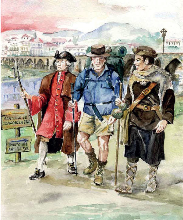
Ponte de Lima no Caminho de Santiago
Ponte de Lima on the Camino de Santiago
![]() 
Localização/acesso: começando na freguesia de Poiares e terminando na freguesia da Labruja, sempre pelo Caminho de Santiago |
Location/access: starting in the parish of Poiares and ending in the parish of Labruja, always along the Camino de Santiago |
Esta cache tem como objetivo dar a conhecer Ponte de Lima ao peregrino que por aqui passa rumo a Santiago, e o Caminho a quem, sendo daqui, nunca o percorreu. |
This cache aims to introduce Ponte de Lima to pilgrims who pass through here towards Santiago, and the Camino to those who, being from here, never travelled it. |
"Herru Santiagu,
Got Santiagu,
E ultreia, e suseia,
Deus adiuva nos."
Codex Calixtinus, “Dum pater families”
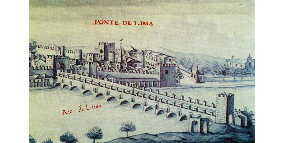
Vindo desde o Porto, entrará no concelho de Ponte de Lima pela freguesia de Poiares, passando depois por Vitorino dos Piães, Facha, Seara, e Correlhã, antes de chegar a Ponte de Lima, a Vila mais Antiga de Portugal, onde poderá pernoitar, explorar o magnífico património e experimentar a famosa gastronomia. Após atravessar a ponte medieval e romana seguirá pela vila de Arcozelo até à Labruja, onde encontrará um desafio que o fará sentir mais forte após o superar, sinalizado pela Cruz dos Franceses. Será um caminho cheio de bonitas imagens rurais e com deslumbrantes paisagens. |
Coming from Porto, you will enter the municipality of Ponte de Lima through the parish of Poiares, passing through Vitorino dos Piães, Facha, Seara, and Correlhã, before reaching Ponte de Lima, the oldest village in Portugal, where you can stay overnight, explore the magnificent heritage and experience the famous cuisine. After crossing the Medieval and Roman bridge, you will continue through the village of Arcozelo to Labruja, where you will find a challenge that will make you feel stronger after overcoming it, signalled by the Cross of the French. It will be a path full of beautiful rural images and stunning landscapes. |
![]() 
Seja muito-bem-vindo ao concelho de Ponte de Lima, um concelho com mais de 320 km2, situado nos vales dos rios Neiva e Lima, e dividido em 39 freguesias (51 antes da reorganização administrativa de 2013). Na sua passagem por Ponte de Lima o Caminho levá-lo-á a conhecer as freguesias de Poiares, Vitorino dos Piães, Facha, Seara, Correlhã, Ponte de Lima, Arcozelo e Labruja, num total de 29 quilómetros que lhe permitirão admirar a diversidade paisagística, geológica e até climatérica do concelho, enquanto apreciará que os costumes e tradições sendo diferentes apresentam um elo comum, a doçura das gentes da Ribeira Lima.
O Caminho de Santiago que, vindo de Barcelos, passa por Balugães, chega à portela da Facha e desce até Ponte de Lima, tem origem provavelmente na Idade Média aquando da construção da ponte de Barcelos nas primeiras décadas do século XIV. Esta travessia terá permitido o surgimento de uma nova rota até Ponte de Lima, hoje a via principal do Caminho Português, substituindo o antigo caminho romano que ligava Braga a Astorga, através de Ponte de Lima e Tui. O Caminho que provém de Braga, e que faz ligação com o Caminho das Torres, continua a existir, porém com menos afluência. Entra no concelho de Ponte de Lima na freguesia de Anais e continua pela Queijada, Fornelos e Arca, até chegar à vila.
A rota que lhe propomos é a mesma que serviu de passagem à grande maioria daqueles que durante os últimos séculos partiram de Portugal em peregrinação a Santiago de Compostela. Siga as setas amarelas e faça-se ao caminho. Faça parte desta história.
Para mais informações, consulte o roteiro detalhado. |
Welcome to the municipality of Ponte de Lima, a municipality with more than 320 km2, located in the valleys of the Neiva and Lima rivers, and divided into 39 parishes (51 before the administrative reorganization in 2013). On your way through Ponte de Lima, the Camino will cross the parishes of Poiares, Vitorino dos Piães, Facha, Seara, Correlhã, Ponte de Lima, Arcozelo and Labruja, for a total of 29 kilometres where you could admire the landscape, geological and even climatic diversity of the municipality, while you will appreciate that the customs and traditions being different present a common root, the gentleness of the people of Ribeira Lima.
The Camino de Santiago that, coming from Barcelos, passes through Balugães, reaches the parish of Facha and descends to Ponte de Lima, has its origin probably in the Middle Ages when the Barcelos bridge was built in the first decades of the 14th century. This would have allowed the appearance of a new route to Ponte de Lima, today the main road of the Camino in Portugal, replacing the old Roman road that linked Braga to Astorga, through Ponte de Lima and Tui. The path that comes from Braga, and that connects with the Caminho das Torres, continues to exist, but with less affluence. It enters the municipality of Ponte de Lima in the parish of Anais and continues through Queijada, Fornelos and Arca, until reaching the town.
The route we propose to you is the same one that served as a passage for the vast majority of those who, during the last centuries, left Portugal on a pilgrimage to Santiago de Compostela. Follow the yellow arrows and get on the way. Be part of this story.
For more information, see the detailed itinerary. |
A cache/The cache
A cache desenrola-se inteiramente no Caminho de Santiago, não obrigando a qualquer desvio significativo do percurso. As coordenadas finais situam-se na freguesia da Labruja, a poucos metros do Caminho.
O acesso às coordenadas finais, onde se encontra a cache, será dado a partir da realização de alguns cálculos simples.
Ponto 1: N 41° 39.232 W 008° 37.866
A cidade de Barcelos dista quantos quilómetros?
Distância = A
Ponto 2: N 41° 39.847 W 008° 37.482
O pilar tem uma data inscrita. Quais os dois primeiros algarismos?
Se 17, então B = 1720
Se 18, então B = 1820
Se 19, então B = 1920
Ponto 3: N 41° 40.427 W 008° 37.084
No local há direções para duas cidades. Quais?
Se Porto e Ponte de Lima, então C = 12
Se Fátima e Santiago, então C = 25
Se Porto e Santiago, então C = 17
Ponto 4: N 41° 40.928 W 008° 37.063
Quantos túmulos “fechados” consegue contar?
N.º de sarcófagos fechados = D
Ponto 5: N 41° 41.230 W 008° 37.282
Ao lado do tanque há quantas pedras ao alto?
N.º de pedras = E
Ponto 6: N 41° 41.850 W 008° 37.453
O que consegue encontrar neste local?
Se alminha, então F = 3
Se cruzeiro, então F = 4
Se nicho, então F = 5
Se nenhuma das anteriores, então F = 6
Ponto 7: N 41° 42.452 W 008° 37.431
Quantas vieiras estão representadas no nicho de Santiago?
N.º de vieiras = G
Ponto 8: N 41° 42.891 W 008° 37.305
Quantas árvores estão representadas no nicho de Santiago?
N.º de árvores = H
Ponto 9: N 41° 43.847 W 008° 37.456
Qual o animal representado na fachada da Casa do Bom Gosto?
Se Javali, então I = 10
Se Galo, então I = 20
Se Veado, então I = 30
Ponto 10: N 41° 44.577 W 008° 37.163
Some o dia, o mês e o ano da data da alminha.
Soma = J
Ponto 11: N 41° 45.073 W 008° 36.651
Quais as coordenadas da Cruz de Santiago?
Se (29,16), então K = 18
Se (9,13), então K = 29
Se (18,15), então K = 9
Ponto 12: N 41° 45.398 W 008° 36.175
Conte o número de faces do fuste do cruzeiro.
N.º de faces = L
Ponto 13: N 41° 46.014 W 008° 35.145
Conte o número de pessoas representadas.
N.º de pessoas = M
Ponto 14: N 41° 46.060 W 008° 35.065
Qual o ano indicado nos relógios da Igreja Matriz?
Ano = N
Ponto 15: N 41° 46.031 W 008° 34.994
Qual a quinta palavra do terceiro verso do lado direito?
Se “deriva”, então O = 11
Se “linda”, então O = 22
Se “imprevisto”, então O = 33
Ponto 16: N 41° 46.089 W 008° 35.075
Quantas cheias consegue contar na face voltada para o rio?
N.º de cheias = P
Ponto 17: N 41° 46.131 W 008° 35.080
Posicione-se sob os primeiros seis candeeiros da ponte. Num e apenas num conseguirá observar os relógios da Igreja Matriz centrados acima da Torre de São Paulo. Qual é o número/ordem desse candeeiro?
N.º do candeeiro= Q
Ponto 18: N 41° 46.169 W 008° 35.259
Na alminha há um painel onde está representado um arcanjo. Qual?
Se Miguel, então R = 2
Se Rafael, então R = 11
Se Gabriel, então R = 7
Ponto 19: N 41° 46.988 W 008° 35.515
O que consegue encontrar neste local?
Se alminha, então S = 11
Se cruzeiro, então S = 16
Se nicho, então S = 23
Se nenhuma das anteriores, então S = 31
Ponto 20: N 41° 47.505 W 008° 35.530
Observe a cachorrada na vertente sul, constituída por 23 elementos. A contar da direita, em qual dos seguintes encontra um busto humano?
Se no 10.º, então T = 37
Se no 12.º, então T = 21
Se no 18.º, então T = 53
Ponto 21: N 41° 47.923 W 008° 35.508
O painel refere as cidades de Astorga, Braga e Santiago de Compostela. Por que ordem?
Se Braga-Astorga-Santiago, então U = 4
Se Astorga-Santiago-Braga, então U = 7
Se Santiago-Astorga-Braga, então U = 15
Ponto 22: N 41° 48.729 W 008° 35.934
Quantos metros terá que percorrer na freguesia da Labruja?
Distância = V
Ponto 23: N 41° 48.998 W 008° 35.886
Consegue ver um gato de Cheshire?
Se sim, então W = 1
Se não, então W = 0
Ponto 24: N 41° 49.200 W 008° 35.949
Conte quantas cascatas consegue ver ou ouvir até chegar à estrada.
N.º de cascatas = X
Ponto 25: N 41° 49.747 W 008° 35.748
Qual o número inscrito no cimo do cruzeiro?
N.º = Y
Ponto 26: N 41° 50.730 W 008° 36.057
No local há um painel que representa um episódio da vida de Jesus. Qual?
Se “Última ceia”, então Z = 7
Se “Crucificação”, então Z = 8
Se “Ressurreição”, então Z = 9
|
The cache takes place entirely on the Camino de Santiago, not requiring any significant deviation from the route. The final coordinates are located in the parish of Labruja, a few meters from the Camino.
Access to the final coordinates, where the cache is located, will be given by performing some simple calculations.
Point 1: N 41° 39.232 W 008° 37.866
How many kilometers are you from Barcelos?
Distance = A
Point 2: N 41° 39.847 W 008° 37.482
The pillar has a date inscribed on it. What are the first two digits?
If 17, then B = 1720
If 18, then B = 1820
If 19, then B = 1920
Point 3: N 41° 40.427 W 008° 37.084
On this place, there are directions for two cities. Which?
If Porto and Ponte de Lima, then C =12
If Fátima and Santiago, then C = 25
If Porto and Santiago, then C = 17
Point 4: N 41° 40.928 W 008° 37.063
How many “closed” tombs can you count?
No. of closed tombs = D
Point 5: N 41° 41.230 W 008° 37.282
How many raised stones are there beside the pool?
No. of stones = E
Point 6: N 41° 41.850 W 008° 37.453
What can you find in this location?
If a wayside shrine, then F = 3
If a wayside cross, then F = 4
If a niche, then F = 5
If none of the above, then F = 6
Point 7: N 41° 42.452 W 008° 37.431
How many scallops are represented in the Santiago niche?
No. of scallop shells = G
Point 8: N 41° 42.891 W 008° 37.305
How many trees are represented in the Santiago niche?
No. of trees = H
Point 9: N 41° 43.847 W 008° 37.456
Which animal is represented on the façade of the Casa do Bom Gosto?
If Boar, then I = 10
If Chicken, then I = 20
If Deer, then I = 30
Point 10: N 41° 44.577 W 008° 37.163
Sum the day, month and year of the wayside shrine’ date.
Sum = J
Point 11: N 41° 45.073 W 008° 36.651
What are the coordinates of the Cross of Saint James?
If (29,16), then K = 18
If (9,13), then K = 29
If (18,15), then K = 9
Point 12: N 41° 45.398 W 008° 36.175
Count the number of sides on the shaft of the wayside cross.
No. of sides = L
Point 13: N 41° 46.014 W 008° 35.145
Count the number of individuals represented.
No. of individuals = M
Point 14: N 41° 46.060 W 008° 35.065
What year is indicated on Main Church clocks?
Year = N
Point 15: N 41° 46.031 W 008° 34.994
Which is the fifth word in the third verse on the right?
If “deriva”, then O = 11
If “linda”, then O = 22
If “imprevisto”, then O = 33
Point 16: N 41° 46.089 W 008° 35.075
How many floods can you count on the front facing the river?
No. of floods = P
Point 17: N 41° 46.131 W 008° 35.080
Position yourself under the first six lamps on the bridge. In one and only one, you will be able to observe the clocks of the Main Church centred above the Tower of São Paulo. What is the number/order of this lamp?
No. of the lamp = Q
Point 18: N 41° 46.169 W 008° 35.259
In the wayside shrine there is a panel where an archangel is represented. Which?
If Michael, then R = 2
If Raphael, then R = 11
If Gabriel, then R = 7
Point 19: N 41° 46.988 W 008° 35.515
What can you find in this location?
If a wayside shrine, then S = 11
If a wayside cross, then S = 16
If a niche, then S = 23
If none of the above, then S = 31
Point 20: N 41° 47.505 W 008° 35.530
Observe the 23 modillions on the front facing south. Counting from the right, in which of the following do you find a human figure?
If the 10th, then T = 37
If the 12th, then T = 21
If the 18th, then T = 53
Point 21: N 41° 47.923 W 008° 35.508
This panel mentions the cities of Astorga, Braga and Santiago de Compostela. In what order?
If Braga-Astorga-Santiago, then U = 4
If Astorga-Santiago-Braga, then U = 7
If Santiago-Astorga-Braga, then U = 15
Point 22: N 41° 48.729 W 008° 35.934
How many meters will you have to walk in the parish of Labruja?
Distance = V
Point 23: N 41° 48.998 W 008° 35.886
Can you see a Cheshire cat?
If yes, then W = 1
If not, then W = 0
Point 24: N 41° 49.200 W 008° 35.949
Count how many waterfalls you can see or hear until you reach the road.
No. of waterfalls = X
Point 25: N 41° 49.747 W 008° 35.748
Which number is inscribed at the top of the wayside cross?
No. = Y
Point 26: N 41° 50.730 W 008° 36.057
In this location there is a panel that represents an episode from the life of Jesus. Which?
If “Last Supper”, then Z = 7
If “Crucifixion”, then Z = 8
If “Resurrection”, then Z = 9
|
Coordenadas finais (cache) / Final coordinates (cache):
N [2*(A+D)-5]° [4*C-L*Y-1].[N-K*I*S+B-A*E-Z*C+Q*(Y+G)]
W [(L+M)/2]° [O+P+Q-D].[(V-H)/(P-W*X)-J*T-U*R*E*A-O*F+5*(C+D)]
A Cache - A cache contém o habitual cache note /log book, e lápis. Tem espaço para trocas.
Por favor voltem a colocar a cache no mesmo local e bem escondida como estava. Esperamos que gostem do passeio. Tirem fotos do local e publiquem.
Obrigado pela vossa visita.
|
The Cache - The cache contains the usual cache note /log book, and pencil. It has space for exchanges.
Please put the cache back in the same place and hidden as it was. We hope you enjoy the tour. Take photos of the place and publish.
Thank you for your visit.
|
Bom Caminho!/Buen Camino!

View Ratings for GC9HZG4
|