Plis gréseux à Porz Donn
Attention, la cache est accessible à mi-marée ou à marée basse. Horaires des marées sont ici.
L’accès se fait par la grève ou par l’escalier.
Il s'agit d'une Earthcache, il n'y a pas de récipient à chercher.
Dévonien
Dans l'Ouest du Massif Armoricain, les formations du Dévonien supérieur : Frasnien et Famennien, sont localisées au cœur de la Rade de Brest, compte tenu de la structure globalement synclinale de la région. Ainsi les localités classiques et les coupes de référence se trouvent à Traonliors, Porsguen, Rostiviec, à la Pointe du Château, au Bindy, à Goasquellou et sur l'autre "rive" en Crozon à Rostellec, Zorn et Ile Longue.

Frasnien (375 Ma à 365 Ma)
La formation Schistes de Rostiviec est une coupe de référence qui date du Dévonien supérieur, plus précisément du Frasnien. La datation est faite par l’analyse de la macrofaune stratigraphique : brachiopodes, bivalves, goniatites, trilobites, conodontes. On y trouve principalement des roches sédimentaires schiste, schiste noir, calcaire et le grès, recoupés par de nombreux filons de roches magmatiques (Kersantite). Ces schistes contiennent des fragments de tiges d’encrines (crinoïdes) fossiles que l’on trouve d’ailleurs pratiquement dans toutes les formations primaires de la rade.
Roche sédimentaire
Les roches sédimentaires proviennent de l'accumulation de sédiments qui se déposent le plus souvent en couches ou lits superposés, appelés strates. Elles résultent de l'accumulation de sédiments divers, c'est-à-dire d'éléments solides (morceaux de roches ou fragments minéraux, débris coquilliers...).
Diagenèse
La diagenèse désigne l'ensemble des processus physico-chimiques et biochimiques par lesquels les sédiments sont transformés en roches sédimentaires. Ces transformations ont généralement lieu à faible profondeur, donc dans des conditions de pression et température peu élevées. Ces transformations engagent des processus variés, notamment : compaction, déshydratation, dissolution, cimentation, et autres. Ainsi le sable devient grès, la vase devient argilite et les galets deviennent conglomérat.
Métamorphisme
Le métamorphisme désigne l'ensemble des transformations subies par une roche (sédimentaire, magmatique ou métamorphique) sous l'effet de modifications de température, de pression, de la nature des fluides minéralisés et, parfois, de la composition chimique de la roche. Pendant l’orogenèse hercynienne (l’ensemble des mécanismes de formation des montagnes) on observe le métamorphisme de l’ensemble des roches sédimentaires : grès (sable d’origine) devient quartzite, l’argilite (vase d’origine) devient schiste.
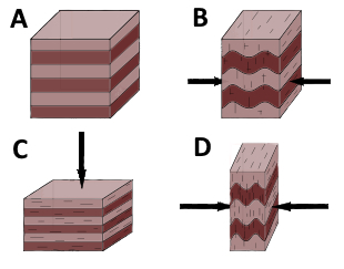
Stratification ou schistosité
Une roche sédimentaire a sa propre stratification, c’est-à-dire une superposition des couches de sédiments (image A), mais aussi sa schistosité (débit en feuillets) qui est perpendiculaire au sens dans lequel la roche a subit les pressions. Dans le cas de l’image C la roche a subit la pression par le haut, la schistosité est parallèle à la stratification. Dans le cas de l’image D la roche a subit les pressions sur les côtés, donc la schistosité est verticale, proche du plan axial des plis — on parlera alors de pli synschisteux.
Schistosité
La schistosité décrit une série de plans sub-parallèles et régulièrement espacés selon lesquels les roches schistosées se débitent facilement en feuillets (taille des ardoises, lauses). Ces feuillets marquent l'aplatissement de la roche schistosée, en général lors d'une phase de déformation.
Les plans de schistosité se développent selon une direction perpendiculaire au plan d'aplatissement maximal. Ils concernent uniquement les minéraux qui peuvent être orientés (minéraux ayant une forme d'aiguille, de prisme ou en plaquettes) et reflètent souvent le fait que des micas (foliation) sont réorientés, ont cristallisé ou recristallisé à plat sur ces plans. À ce titre, la schistosité est souvent caractéristique des roches métamorphiques par la venue de minéraux néoformés appelés blastes (les cristaux relictuels se nommant quant à eux clastes).
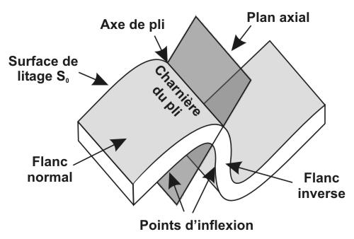
Plis
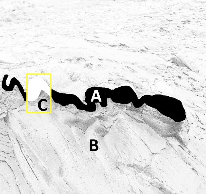
A Pors Donn la roche est constituée de schiste, dans lequel s’intercale un banc gréseux de couleur brune. La schistosité liée aux plissements naît d'une réorganisation de la matière (rotation et/ou dissolution sous pression des minéraux) et s'accompagne d'un aplatissement notable de la roche. Ce phénomène est clairement mis en évidence par la déformation des fossiles mais aussi, dans certains cas par le "bouclage" des petits bancs gréseux. Celui-ci présente une allure très originale : il forme des microplis, qui témoignent d’une schistosité de crénulation affectée à la roche lorsqu’elle était enfouie à plus grande profondeur. Ces niveaux, ne pouvant se déformer plastiquement, répondent aux sollicitations tectoniques en se contournant pour "tenir" dans un volume de forme nouvelle.

Sources
Wikipédia
pmb.bretagne-vivante.org : Penn Ar Bed N°144, 145
Questions pour valider cette Earthcache :
- A partir de quels sédiments et comment se sont formés des schistes ? De quelle couleur est cette roche aux coordonnées ?
- Quels sédiments sont à l’origine des grès ? Quelle est la couleur du grès aux coordonnées ?
- Expliquez qu'est-ce qu'une stratification ?
- Expliquez qu'est-ce qu'une schistosité ?
- Imprimez le croquis du pli gréseux vu en coupe. Observez la coupe sur place, puis indiquez quelle zone représente la stratification (A ou B) et où on voit la schistosité (A ou B) ?
- Indiquez par des flèches le sens les forces maximales d’aplatissement des schistes.
- Dessinez le pli C et indiquez son plan axial. Joignez le croquis avec vos annotations à vos réponses.
- Est-ce que le plan axial du pli gréseux correspond à la schistosité de la roche noire ? Peut-on parler ici d’un pli synschisteux ?
- Une photo de vous ou d’un objet vous représentant sur le site.
Loguez cette cache "Found it" et envoyez-moi vos propositions de réponses soit via mon profil, soit via la messagerie geocaching.com (Message Center), et je vous contacterai en cas de problème. Les logs enregistrés sans réponses seront supprimés.
English version
Sandstone folds at Porz Donn
Please note, the cache is accessible at mid-tide or at low tide. Tide times are here. Access is via the strike or the staircase.
You engage in the search for this cache on your own initiative at your own risk. I therefore decline all responsibility in the event of a problem.
This is an Earthcache, there is no container to look for.
Devonian
In the western part of Armorican Massif, the Upper Devonian formations: Frasnian and Famennian, are localized in the middle of Rade de Brest, considering the globally synclinal structure of the region. Thus, the classical localities and the reference cross section are found at Traonliors, Porsguen, Rostiviec, at Pointe du Château, at Bindy, at Goasquellou and on the other "shore" in the region of Crozon at Rostellec, Zorn and Ile Longue.
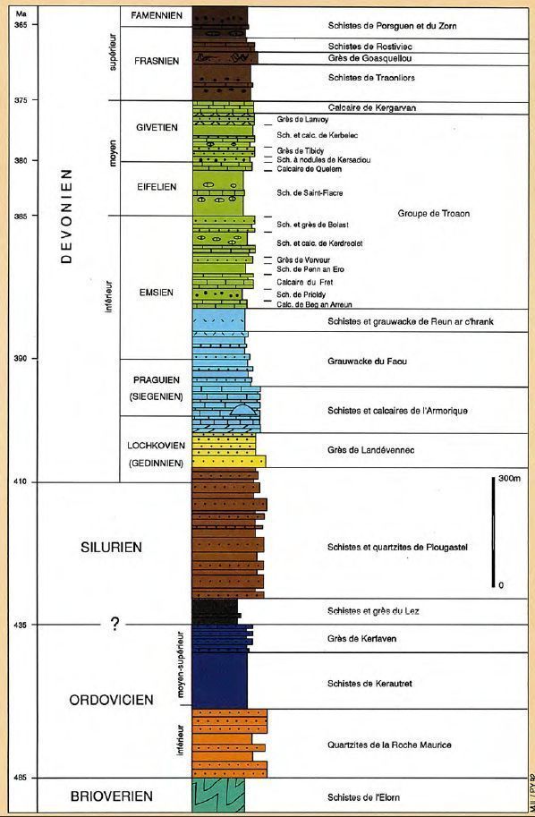
Frasnien (375 Ma to 365 Ma)
The Rostiviec Shale formation is a reference cross-section that belongs to the Upper Devonian, more precisely to the Frasnian. The dating is done by the analysis of the stratigraphic macrofauna: brachiopods, bivalves, goniatites, trilobites, conodonts. Sedimentary rocks are mainly shales, black schists, limestone and sandstone, crossed by numerous veins of magmatic rocks (Kersantite, microgranite). These shales contain fragments of fossilized stems (crinoids) which are found in practically all the primary formations of the harbor.
Sedimentary rock
Sedimentary rocks come from the accumulation of sediments that are most often deposited in layers or superimposed beds, called strata. They result from the accumulation of various sediments, that is to say solid elements (pieces of rock or mineral fragments, shell debris, etc.).
Diagenesis
Diagenesis refers to all the physicochemical and biochemical processes by which sediments are transformed into sedimentary rocks. These transformations generally take place at shallow depth, therefore under conditions of low pressure and temperature. These transformations involve various processes, in particular: compaction, dehydration, dissolution, cementation, and others. So the sand becomes sandstone, the silt becomes argillite and the pebbles become conglomerate.
Metamorphism
Metamorphism refers to all the transformations undergone by a rock (sedimentary, magmatic or metamorphic) under the effect of changes in temperature, pressure, the nature of mineralized fluids and, sometimes, the chemical composition of the rock. During orogeny (all the mechanisms of mountain formation) we observe the metamorphism of all sedimentary rocks: sandstone (original sand) becomes quartzite, argillite (original mud) becomes schist.
Stratification or schistosity
A sedimentary rock has its own stratification, that is to say a superposition of layers of sediment (image A), but also its schistosity (flow in layers) which is perpendicular to the direction in which the rock has undergone the pressures. In the case of image C the rock a is under pressure from above, the schistosity is parallel to the stratification. In the case of image D, the rock has been subjected to the pressure on the sides, so the schistosity is vertical, close to the axial plane of the folds - we will then speak of a synschistous fold.

Schistosity
The schistosity describes a series of sub-parallel and regularly spaced planes according to which the schistose rocks are easily cut into sheets (size of slates, lauses). These layers mark the flattening of the schistose rock, generally during a deformation phase.
The schistosity planes develop in a direction perpendicular to the maximum flattening plane. They relate only to minerals that can be oriented (minerals having a needle, prism, or platelet shape) and often reflect the fact that micas (foliation) are reoriented, crystallized, or recrystallized flat on these planes. As such, schistosity is often characteristic of metamorphic rocks by the arrival of newly formed minerals called blasts (the relict crystals are called clasts).
Folds
In Pors Donn the rock consists of schist, in which a sandstone bank of brown color is inserted. The schistosity linked to the folds arises from a reorganization of the material (rotation and / or dissolution under pressure of the minerals) and is accompanied by a notable flattening of the rock. This phenomenon is clearly demonstrated by the deformation of the fossils but also, in certain cases, by the "looping" of the small sandstone beds. This has a very original appearance: it forms microplates, which testify to a crenulation schistosity affected by the rock when it was buried at a greater depth. These levels, not being able to deform plastically, respond to tectonic stresses by bypassing themselves to "fit" in a volume of new shape.
Questions to validate this Earthcache:
1. From which sediments and how were shales formed? What color is this rock at coordinates?
2. What sediments are at the origin of sandstones? What is the color of the sandstone at the coordinates?
3. Explain what is a stratification?
4. Explain what is schistosity?
5. Print the sketch of the sandstone fold seen in section. Observe the section on the spot, then indicate which zone represents the stratification (A or B) and where we see the schistosity (A or B)?
6. Indicate with arrows the direction of the maximum flattening forces of the shales.
7. Draw the fold C and indicate its axial plane. Attach the sketch with your notes to your answers.
8. Does the axial plane of the sandstone fold correspond to the schistosity of the black rock? Can we speak here of a synschistous fold?
9. A photo of you or an object representing you on the site.

Log this "Found it" cache and send me your suggested answers either via my profile or via geocaching.com (Message Center), and I will contact you in the event of a problem. Logs recorded without response will be deleted.