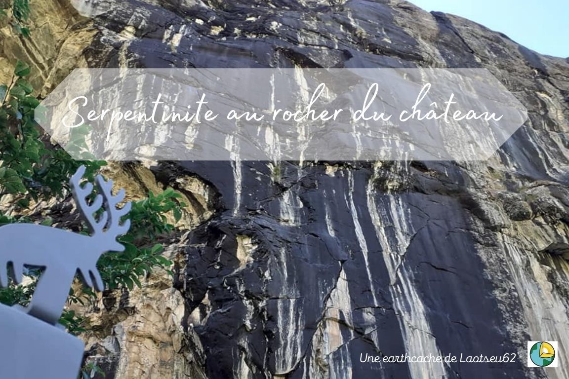
Le rocher du château:
Le Rocher du Château est un site préhistorique datant du Néolithique situé sur la commune de Bessans, en Savoie, à quelques kilomètres des gravures rupestres du Grand roc Noir. Il est particulièrement notable en raison de ses peintures rupestres, notamment un groupe de huit cerfs
réalisés à l'ocre rouge.
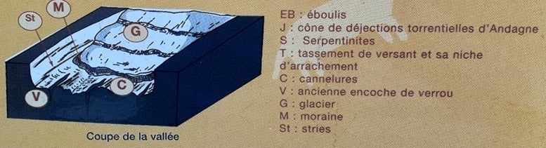
Le site se trouve au pied de la falaise du Rocher du Château, à une altitude de 1750 mètres et sur la rive droite de l'Arc. Cette falaise d'une hauteur de près de 100 mètres formait un verrou glaciaire. Elle est constituée de serpentinite polie par le passage des glaces. (Source: Wiki)
La serpentinite:
Les serpentinites du Rocher du château résultent de la transformation de péridotites. Cette évolution s'est faite en plusieurs étapes.
1 Il y a environ 150 Ma, les péridotites formaient (roche magmatique grenue vert sombre formée de péridot (olivine) et de pyroxènes essentiellement) le fond de l'ancien océan alpin qui était en expansion plusieurs centaines de kilomètres au Sud-Est.
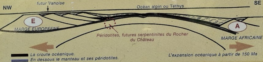
La serpentinisation s'est amorcée dans l'océan, par hydratation des minéraux ferro-magnésiens. Elle s'est poursuivie au cours du métamorphisme de ces roches pendant la subduction et a conduit au minéraux classiques des serpentines, l'antigorite et le chrysolite de couleur vert-pétrole à vert-noir.
La subduction a débuté vers 100Ma, lorsque les plaques africaines et européennes ont convergé. Passant sous la marge africaine (A sur le croquis) c'est alors que la croute connait un métamorphisme important.
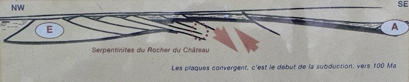
2 Postérieurement, à partir de 30 Ma la convergence des plaques entraînent aussi un retour des serpentinites vers la surface, ou elles sont charriées sur les roches de l'ancienne marge européénnes (E sur le croquis).
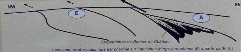
Les premiers reliefs vont alors s'ébaucher et les processus d'érosion débuter, notamment les processus d'érosion glaciaire.
3 L'activité glaciaire et sous-glaciaire va façonner la vallée en forme de U, les roches relativement dures vont former verrou alors que les roches tendres favorisent l'élargissement de la vallée et la naissance d'ombilics (partie élargie d'une vallée glaciaire située en ). Les stries et le cannelures observables sur les serpentinites ainsi que les moraines conservées sont les marques des passages des glaciers.
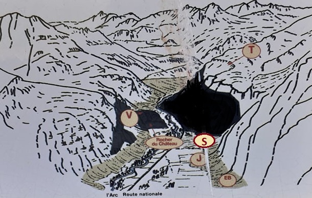
Depuis un peu moins de 10 000 ans, le comblement des lacs d'ombilics et de retenues morainiques, le rééquilibrage des versants par tassement, écroulement, éboulisation et enfin la végétalisation ne font que retoucher le cadre morphologique des serpentinites du rocher du château.
(Source: panneaux d'informations)
Pour valider cette earthcache:
Je rappelle qu'il n'y a pas de boites à trouver sur place mais des observations à faire et des reponses à envoyer.
1- Expliquez rapidement comment se sont formés les serpentinites du rocher du château. (Descriptif)
2- De gros blocs de serpentinites sont présent sur le site au pied du roc principal (au Sud Est) ceux-ci sont fragmentés.
Décrivez-les (couleurs, composition, dureté...)
3- Diriez-vous que les principales fractures visibles sur ces blocs sont naturelles ou faites par l'homme. Justifiez.
4- Décrivez l'élément qui vient perturbé la nature principale de la roche et visible sur les deux gros blocs au niveau des fractures.
5- Prenez une photo de vous, de votre GPS ou d'un élément permettant de vous identifier sur place (logo, mascotte...) avec le roc du château en arrière plan (avec les peintures rupestres par exemple...) Merci de ne pas dévoiler d'éléments de réponses dans vos photos.
Le rocher du château:
The Rocher du Château is a prehistoric site dating from the Neolithic era located in the town of Bessans, in Savoy, a few kilometers from the rock engravings of the Grand roc Noir. It is particularly notable for its cave paintings, including a group of eight deer
made in red ocher.
The site is located at the foot of the Rocher du Château cliff, at an altitude of 1750 meters and on the right bank of the Arc. This cliff, with a height of nearly 100 meters, formed a glacial lock. It consists of serpentinite polished by the passage of ice. (Source: Wiki)
The serpentinite:
The serpentinites of the Rock of the Castle result from the transformation of peridotites. This development took place in several stages.

1 About 150 Ma ago, peridotites formed (a dark green grainy magmatic rock formed of peridot (olivine) and pyroxenes mainly) the bottom of the ancient alpine ocean which was expanding several hundred kilometers to the south-east.
Serpentinization began in the ocean, by hydration of ferro-magnesian minerals. It continued during the metamorphism of these rocks during subduction and led to the classic serpentine minerals, antigorite and chrysolite of petroleum green to green-black color.

Subduction started around 100Ma, when the African and European plates converged. Passing under the African margin (A on the sketch) it is then that the crust undergoes an important metamorphism.
2 Later, from 30 Ma, the convergence of the plates also causes the serpentinites to return to the surface, where they are carried on the rocks of the old European margin (E on the sketch).
The first reliefs will then take shape and the erosion processes will begin, in particular the processes of glacial erosion.

3 Glacial and subglacial activity will shape the valley in the shape of a U, the relatively hard rocks will form a lock while the soft rocks favor the widening of the valley and the birth of umbilics (widened part of a valley glacial located in). The striations and the grooves observable on the serpentinites as well as the preserved moraines are the marks of the passages of the glaciers.
For a little less than 10,000 years, the filling of umbilicus lakes and moraine reservoirs, the rebalancing of the slopes by settlement, collapse, landslide and finally revegetation have only changed the morphological framework of the serpentinites of the castle rock.
(Source: information boards)

To validate this earthcache:

I remind you that there are no boxes to find on the spot but observations to make and answers to send.

1- Explain quickly how the serpentinites of the rock of the castle were formed. (Description)

2- Large blocks of serpentinites are present on the site at the foot of the main rock (to the South East), these are fragmented.
Describe them (colors, composition, hardness ...)
3- Would you say that the main fractures visible on these blocks are natural or man-made. Justify.
4- Describe the element which disturbs the main nature of the rock and is visible on the two large blocks at the level of the fractures.

5- Take a photo of you, your GPS or an element allowing you to identify yourself on the spot (logo, mascot ...) with the rock of the castle in the background (with the cave paintings for example ...) Thank you not to reveal any answers in your photos.