Meandros da ribeira do Tedo EarthCache
Meandros da ribeira do Tedo
-
Difficulty:
-

-
Terrain:
-

Size:  (other)
Please note Use of geocaching.com services is subject to the terms and conditions
in our disclaimer.

Meandros/Meanders
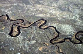
Designa-se por "meandro" a curva acentuada de um rio que corre numa planície aluvial. O termo deriva do rio Meandro, na Turquia, caracterizado por um curso muito sinuoso, e tem sido utilizado desde o século XVI.
Os meandros mudam de forma e de posição conforme as variações de energia e de carga fluviais. Originam-se e evoluem devido à força dinâmica do fluxo fluvial, à força de Coriolis, e aos processos geomorgológicos.
A "meander" is a bend in a sinuous watercourse or river flowing in a floodplain. The term derives from the Meander River in Turkey, characterized by a very winding course, and has been used since the sixteenth century.
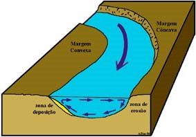
A meander forms when moving water in a stream erodes the outer banks and widens its valley, and the inner part of the river has less energy and deposits silt.
Evolução dos meandros/Meanders evolution
- 1ª fase - A velocidade do fluxo fluvial é maior na parte externa do que na parte interna do meandro provocando erosão na margem côncava e deposição de sedimentos na margem convexa.
- 1st phase - The speed of the river flow is greater on the outside than on the inside of the meander causing erosion on the concave bank and deposition of sediments on the convex side.
|

|
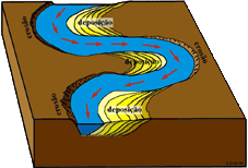
- 2ª fase - Com o avançar do tempo o curso fluvial tem tendência permanente para se deslocar na direcção da margem côncava do meandro sendo a sua curvatura cada vez maior.
- 2nd phase - Over time the river course has permanent tendency to move towards the concave edge of the meander and increasing its curvature.
|
|
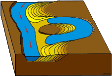
- 3ª fase - Por vezes, o meandro atinge, praticamente, os 360º, deixando a corrente fluvial de o utilizar, passando a fluir pela via mais directa e fácil. O meandro acaba, consequentemente, por ficar inactivo. Origina-se, assim, um meandro abandonado, correspondente a um lago em forma de U.
- 3rd phase - Sometimes the meander reaches practically 360 degrees, leaving the river course and going to flow by the most direct and easy route. It originates therefore an abandoned meander, corresponding to a U-shaped lake.
|
|
A EarthCache
Esta earthcache está situada junto à Foz da ribeira do Tedo.
This EarthCache is situated near the mouth of the Tedo river.
Para efetuar o log nesta earthcache é necessário visitar o local e enviar-me as respostas, através da minha página de perfil, às seguintes questões:
To log this earthcache is necessary to visit the site and send me the answers to the following questions through my profile page:
1 - Em qual das 3 fases indicadas se enquadra o meandro que fica exatamente abaixo do ponto de observação?
1 - In which of the 3 phases indicated is the meander which is situated right below the point of observation?
2 - Explique se é previsível ou não que este meandro continue a evoluir e porquê.
2 - Explain whether or not is anticipated that this meander will continue to evolve and why.
3 - Consegue observar mais algum meandro deste ponto de observação? Quantos e em que fases se encontram os mesmos?
3 - Can you see any more meanders from this observation point? How many and in what stages are they?
Adicionalmente, gostaria de ver fotos da vossa visita ao local desde que as mesmas não apresentem as respostas a esta earthcache. No entanto a sua inclusão é opcional.
Additionally, I would like to see photos of your visit to the site as long as they do not present any responses to this earthcache. However their inclusion is optional
Referência/Reference
Sistemas fluviais
Wiki Meandros


Additional Hints
(No hints available.)