|
(english? please, scroll down) |
O Circo Glaciário de Cocões de Coucelinho, localizado no vale do Couce, é o circo da Serra do Gerês que apresenta uma forma glaciária mais típica. As geoformas glaciárias do Gerês são do Plistocénico (a última glaciação terá sido a de Wurm entre 110.000 anos e os 10.000 anos atrás).
Quando estiver perante este monumento natural irá sentir a sua presença impactante, a sua imponência, a sua envolvência… é como uma pegada gigante do glaciar, gravada no granito… Aprecie, desfrute e siga os passos do glaciar no resto do vale.
Circo Glaciário
Um circo é uma forma glaciária de erosão, em anfiteatro, rodeada por vertentes abruptas. É uma área de acumulação de gelo que normalmente alimenta uma língua glaciar que se desenvolve ao longo do vale. Os circos são, portanto, as zonas de cabeceira a partir das quais o glaciar lança os seus braços abrasivos sobre a montanha, arredondando os vales, transformando-os em condutas de gelo.
O Circo Glaciário de Cocões de Coucelinho tem uma altura considerável atingindo no seu topo uma altitude de 1483 m. É a forma erosiva glaciária mais nítida da Serra do Gerês, exibindo uma típica forma côncava, em anfiteatro, rodeada por encostas íngremes. O facto de esta geoforma ter chegado à actualidade bem preservada indica que esta zona terá sido ocupada pelo glaciar até uma fase tardia (mais recente) da glaciação do Gerês. Em alguns circos, após a deglaciação, forma-se um lago no seu interior. Se alguma vez este circo albergou um lago, é evidente que ele não sobreviveu até aos nossos dias.
A litologia deste circo é o "Granito do Gerês" que é a rocha que predomina na zona central do Gerês. É uma rocha “porfiróide de grão grosseiro a médio” que apresenta com frequência uma coloração rosada relacionada com o feldspato potássico.
Vale Glaciário do Couce
A dinâmica glaciar imprime uma forma em U ao vale e deixa nele gravados outros vestígios glaciários típicos.
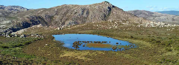
O vale do Couce é onde se encontra a paisagem glaciária mais expressiva de todo o Gerês. É um vale glaciário com forma ampla, com o fundo a cerca de 1150 m de altitude, suspenso sobre o rio Cabril que corre 350 m abaixo. Em relação à litologia, para além do granito já referido, aflora também neste vale um granito de textura mais fina, o "Granito dos Carris" (é uma rocha "granular de grão fino, por vezes porfiróide").
As moreias altas presentes nas encostas do vale, permitem inferir que a língua glaciar terá atingido uma espessura de 150 m de altura. Outros vestígios glaciários que se podem observar neste vale são os blocos erráticos, polimentos, estrias, afloramentos de till e lagos glaciários.
Polimentos e Estrias
As rochas da base do circo de Cocões de Coucelinho exibem marcas de abrasão provenientes da passagem de uma massa de gelo e sedimentos. Essas marcas são polimentos e estrias que se podem ver nas superfícies polidas das rochas de granito ou até na superfície de alguns megacristais de feldspato potássico. Alguns blocos morénicos apresentam também estrias em “V”.
Blocos Erráticos
Os Blocos Erráticos são blocos que foram transportados pelo glaciar e que após o degelo acabaram depositados numa posição mais ou menos isolada na paisagem, longe da sua origem (muitas vezes são depositados a muitos quilómetros de distância, por vezes sobre uma litologia completamente diferente).
No vale do Couce podem ser observados vários blocos de grandes dimensões (com alguns metros de diâmetro) dispersos, alguns depositados sobre as áreas planas de rocha polida.
Seria interessante encontrar um bloco errático de "Granito do Gerês" repousando isolado sobre uma laje nua e polida de "Granito de Carris".
Moreias
As moreias são formas glaciárias de acumulação. O movimento de arraste do gelo pela montanha abaixo leva ao arranque de calhaus e blocos de grandes dimensões (alguns com várias toneladas), que após o degelo acabam acumulados em determinados alinhamentos. As moreias laterais correspondem aos limites laterais da língua glaciária (estas moreias ficam depositadas ao longo das margens do glaciar, por isso não são normalmente afectadas pela erosão fluvial que ocorre posteriormente no fundo dos vales e ficam por isso preservadas em alinhamentos altos nas vertentes ao longo dos vales).
As
moreias frontais são formadas na frente da língua de gelo. A moreia frontal que fica quando o glaciar recua é chamada de
moreia terminal pois marca o seu avanço máximo. As
moreias centrais (ou medianas) formam-se no alinhamento longitudinal de contacto entre duas línguas glaciares, onde se fundem as respectivas moreias laterais.
No vale do Couce as moreias são acumulações pouco espessas, por vezes reduzidas a blocos de grandes dimensões, alinhados em fila. Estes depósitos distinguem-se das escombreiras e de outras escoadas de detritos, pela posição afastada que têm em relação às vertentes mais inclinadas (não podendo assim o seu transporte ser explicado pela ação da gravidade), pela sua forma em crista ou em arco, pela grande dimensão de alguns blocos e pelo carácter arredondado dos mesmos. A descoberta de algumas moreias laterais permitiu inferir que a língua glaciar neste vale terá atingido 150 m de altura. A disposição de algumas moreias indicam que terá havido várias fases de avanço e recuo desde que se iniciou a deglaciação e o recuo da língua de gelo desde o Lago Marinho (também chamado de "Lagoa do Marinho").
Lagos Glaciários
Os Lagos Glaciários terminais formam-se após o recuo do glaciar, em depressões criadas pela erosão do gelo associada à grande quantidade de material acumulado na frente do glaciar que passa a funcionar como barragem.
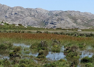
No vale do Couce existem dois pequenos lagos glaciários, os únicos presentes na Serra do Gerês e no norte de Portugal. O Lago Marinho, o maior deles, é uma turfeira de montanha. A acção erosiva do gelo glaciário formou ali uma pequena depressão. Com o degelo e com o recuo do glaciar, ficaram acumulados na zona terminal materiais (blocos e sedimentos finos) que foram levados para ali pela língua de gelo. Estes depósitos bloquearam o escoamento das águas contribuindo para a formação do lago. Assim, após o degelo aquela depressão transformou-se num lago onde se foi acumulando matéria orgânica (sobretudo vegetal) e outros sedimentos, numa típica turfeira de montanha. A matéria orgânica não é facilmente decomposta, devido ao ambiente pobre em oxigénio que existe no fundo do lago e por isso vai-se acumulando ali, num processo que dará origem à formação de turfa.
Txt. e adapt. de imag. - JPD
Algumas coordenadas de pontos de interesse no Circo Glaciário e no Vale do Couce:
- Polimentos e blocos erráticos: N 41º 47.039 W 008º 03.130
- Moreia (central? frontal?): N 41º 46.175 W 008º 02.907
- Lago Marinho: N 41º 45.716 W 008º 02.686
- Fonte com água de montanha: N 41º45.853 W 008º 02.875
- Casa de Abrigo: N 41º 45.856 W 008º 02.903
Para reclamar este earthcache, envie-me um email com a resposta às seguintes perguntas:
- Qual o nome do granito em que o circo glaciário foi esculpido?
- Qual é a largura aproximada do topo do circo glaciário?
a) 10 km b) 1,0 km c) 0,1 km
- Qual a altura aproximada do circo glaciário, da base ao topo?
a) 0,022 km b) 0,22 km c) 2,2 km
- Qual a extensão aproximada do vale do Couce (do circo glaciário até ao Lago Marinho)?
a) 0,36 km b) 3,6 km c) 36 km
- Em que vale se encontra a paisagem glaciária mais expressiva de todo o Gerês?
(OPCIONAL) Inclua uma ou mais das seguintes fotos no seu log:
- tire uma uma “selfie” nas coordenadas desta earthcache.
- tire uma foto ao circo glaciário.
- tire uma foto à extensão total do vale glaciário do Couce desde uma das suas extremidades.
- tire uma foto a uma superfície polida.
- tire uma foto a estrias glaciárias.
- tire uma foto a um bloco errático de grandes dimensões que encontre no vale do Couce.
- tire uma foto a um bloco errático de "Granito do Gerês" sobre uma laje de "Granito de Carris", mostrando o contraste entre as duas litologias.
- tire uma foto a uma moreia no vale do Couce.
- tire uma foto a um lago glaciário.

The Cocões de Coucelinho Glacial Cirque, located in the Couce valley, is the cirque that presents the most typical glacial form of Serra do Gerês. The glacial geoforms in Gerês are from the Pleistocene (the last one was the Wurm glaciation, between 110,000 years and 10,000 years ago).
When you are in front of this natural monument, you will feel its impressive presence, its magnificence… it is like a giant footprint left by the glacier, engraved in the granite… Appreciate, enjoy and follow the footsteps of the glacier in the rest of the valley.
Glacial Cirque
A cirque is a glacial form of erosion, amphitheater-shaped, surrounded by steep slopes. It is an area of ice accumulation that normally feeds a glacial tongue that develops along the valley. Cirques are, therefore, the headlands from which the glacier launches its abrasive arms over the mountain, molding the valleys, transforming them into ice conduits.
The Cocões de Coucelinho Glacial Cirque has a considerable height reaching at its top an altitude of 1483 m. It is the clearest glacial erosive form in Serra do Gerês, exhibiting a typical concave shape, amphitheater-shaped, surrounded by abrupt slopes. The fact that this geoform is well preserved indicates that this area was occupied by the glacier until a late (more recent) phase of the Gerês glaciation. In some cirques, after deglaciation, a lake is formed inside. It's not certain if ever this cirque housed a lake, but it is evident that it has not survived to this day.
The lithology of this cirque is the "Granito do Gerês" which is the predominant rock in the central area of Gerês. It is a “porphyritic coarse to medium grained rock” that often has a pinkish coloration related to the potassium feldspar.
Glacial Valley of Couce
The glacial dynamics imprints a U-shape to the valley and leaves other typical glacial traces engraved on it.
The most expressive glacial landscape in all of Gerês is located in the Couce valley. It is a glacial valley with a wide shape, with the bottom at about 1150 m of altitude, suspended over the river Cabril, that runs 350 m below. In terms of lithology, in addition to the granite already mentioned, also outcrops in this valley a fine-grained granite, that is designated "Granito de Carris" (a "granular, fine-grained, sometimes porphyritic").
The moraines present on the slopes of the valley allow us to infer that the glacial tongue reached a thickness of 150 m in height. Other glacial remains, that can be seen in this valley, are erratic blocks, polished surfaces, striations, till outcrops and glacial lakes.
Polishes and Striations
The rocks at the base of the Cocões de Coucelinho cirque exhibit abrasion marks from the passage of a mass of ice and sediments. These marks are polishes and striations that can be seen on the polished surfaces of granite rocks or even on the surface of some potassic feldspar megacrystals. Some morenic blocks also have “V” grooves.
Erratic Blocks
Erratic Blocks are blocks that were transported by the glacier and that after the melting, ended up deposited in a more or less isolated position in the landscape, far from their origin (they are often deposited many kilometers away, sometimes on a completely different lithology).
In the Couce valley several large blocks (a few meters in diameter) can be seen scattered, some deposited on flat areas of polished rock.
It would be interesting to find an erratic block of "Granito do Gerês" resting isolated on a bare and polished slab of "Granito de Carris".
Moraines
Moraines are glacial forms of accumulation. The drag movement of the ice down the mountain leads to the removal of large boulders and blocks (some with several tons), which after the thaw, end up accumulated in certain alignments. The lateral moraines correspond to the sides of the glacial tongue (these moraines are deposited along the glacier margins, so they are not normally affected by fluvial erosion that occurs later in the valley floor and are therefore preserved on high slope alignments along the valleys).
The
end moraines are formed in front of the ice tongue. The end moraine that is left when the glacier retreats is called the
terminal moraine because it marks its maximum advance. The
medial moraines are formed in the longitudinal alignment of contact between two glacial tongues, where the respective lateral moraines merge.
In the Couce valley, moraines are thin accumulations, sometimes reduced to large blocks, lined up in a row. These deposits are distinguished from other type of debris, by the remote position they have in relation to the steepest slopes (thus their transport cannot be explained by the action of gravity), by their crest or arched shape, by the large size of some blocks and their rounded character. The discovery of some lateral moraines allowed to infer that the glacial tongue in this valley must have reached 150 m in height. The disposition of some moraines indicates that there was several phases of advance and retreat since the beginning of the deglaciation, and from the retreat of the ice tongue from Lago Marinho (also called "Lagoa do Marinho").
Glacial Lakes
The terminal glacial lakes form after the glacier retreats, in depressions created by the erosion of the ice associated with the large amount of material accumulated in front of the glacier, which function as a dam.
In the Couce valley there are two small glacial lakes, the only ones present in Serra do Gerês and in the north of Portugal. Lago Marinho, the largest of them, is a mountain peat bog. The erosive action of the glacial ice formed a small depression there. With the melting and the retreat of the glacier, materials (blocks and fine sediments) accumulated in the terminal zone, which were carried there by the tongue of ice. These deposits blocked the flow of water, contributing to the formation of the lake. Thus, after the thaw, that depression turned into a lake where organic matter (mainly vegetable) and other sediments accumulated, in a typical mountain peat bog. Organic matter is not easily decomposed, due to the oxygen-poor environment that exists at the bottom of the lake and therefore accumulates there, in a process that will give rise to the formation of peat.
Some coordinates of points of interest in the Glacial Cirque and Couce valley:
- Polished rocks and erratic blocks: N 41º 47.039 W 008º 03.130
- Moraine (medial? end?): N 41º 46.175 W 008º 02.907
- Lago Marinho: N 41º 45.716 W 008º 02.686
- Water source: N 41º45.853 W 008º 02.875
- Shelter House: N 41º 45.856 W 008º 02.903
To claim this earthcache, send me an email with the answer to the following questions:
- What is the name of the granite in which the glacial cirque was carved?
- What is the approximate width of the top of the glacial cirque?
a) 10 km b) 1.0 km c) 0.1 km
- What is the approximate height of the glacial cirque from bottom to top?
a) 0.022 km b) 0.22 km c) 2.2 km
- What is the approximate extension of the Couce valley (from the glacial cirque to Lago Marinho)?
a) 0.36 km b) 3.6 km c) 36 km
- In which valley of Gerês there is the most expressive glacial landscape?
(OPTIONAL) Include one or more of the following photos in your log:
- take a selfie at the coordinates of this earthcache.
- take a picture of the glacial cirque.
- take a photo of the full extent of the glacial valley of the Couce from one of its ends.
- take a picture of a polished surface.
- take a picture of glacial striations.
- take a picture of a large erratic block you found in the Couce valley.
- take a picture of an erratic block of "Granito do Gerês" resting on a slab of "Granito de Carris",showing the contrast between the two lithologies.
- take a picture of a moraine in the Couce valley.
- take a picture of a glacial lake.