(English below)
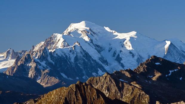
Le Mont Blanc est la plus haute montagne d'Europe à 4808 mètres d'altitude. Elle est située dans les Alpes et possède une structure géologique très intéressante...
Géologie
Le Mont Blanc est situé dans le massif du Montblan à la frontière franco-italienne. Le Mont Blanc s'étend selon les points de contact des plaques continentales, entre africain et européen. Son isolement par rapport aux autres hautes montagnes tient au fait qu'il s'élève au milieu d'une zone à déclin prédominant. Au pied de la montagne, vers la Vallée d'Aoste (Val d'Aoste), se trouve une plaine souterraine escarpée qui a submergé la plaque européenne sous la chaîne alpine. Vers la Savoie, la plaque continentale européenne se replie (comme un paillasson) en glissant sur un obstacle. La vallée de Chamonix, plaquée contre les Aiguilles Rouges et bloquée derrière le Mont Blanc, se rétrécit selon ce modèle déformant.
La diversité du Mont Blanc par rapport au relief environnant vient du matériau qui le compose. Sa roche a été formée à partir de magma, qui a été trouvé dans les parties chaudes profondes de la plaque continentale.
Bien qu'un réseau de fractures y passe, le massif maintient la cohésion du bloc solide. En réponse aux contraintes internes du système, il ne s'est pas désintégré ou effondré comme les roches sédimentaires autour de lui, mais a acquis une forme d'amande typique.
Roches massives
Les roches de la plaque continentale sont très anciennes et souvent transformées. Le Mont Blanc est constitué essentiellement d'un noyau de granite recouvert de gneiss. La couche externe du manteau provient d'anciennes roches sédimentaires qui se sont déformées au Paléozoïque (il y a environ 542 à 251 millions d'années). Cette coquille est conservée dans la partie sud-ouest du massif, à partir du sommet supérieur vers l'Aiguille des Glaciers et au-delà, ainsi que dans la partie inférieure de la Savoie et de la Vallesana. Au Carbonifère (il y a environ 310 millions d'années), une grande partie de cette roche a surchauffé et fondu. Il a ensuite été refroidi pour former un noyau granitique de quartz, de feldspath (parfois de gros cristaux blancs tassiques de section rectangulaire) et de mica noir, qui ont parfois été remplacés par de la chlorite verdâtre. De la même manière que le gneiss, le granite a des parties plus sombres et est recoupé par de petits cristaux de feldspath. Le contact avec le gneiss d'emballage peut être identifié approximativement à la hauteur du Montenvers et dans le Val Veny le long de la crête du Brouillard.
Ascension et achèvement du massif
Il y a une vingtaine de millions d'années, la plaque européenne rencontra la plaque africaine. L'ascension du Mont Blanc a commencé lorsque le massif à l'intérieur de la plaque européenne s'est retrouvé sur le bord. De par sa petite taille et sa relative légèreté, il a été poussé à la surface au bord du sillon, contre les pentes de la chaîne alpine. A l'intérieur de la dalle, où le Mont Blanc était (et est encore partiellement) immergé, le massif a absorbé une énorme quantité d'énergie et s'est un peu réchauffé, de sorte que des fluides chargés de silice s'écoulaient dans les fissures créées par les déformations. La lente cristallisation de ces fluides a donné naissance au quartz, exposé dans de nombreux musées français.
Au cours de son ascension, le Mont Blanc a connu divers cycles d'accumulation glaciaire à son sommet et sur tout son territoire. De nombreuses vallées profondes se sont formées, s'approfondissant dans les roches douces environnantes. Les grands glaciers se sont engagés sur un chemin de profonde dépression qui existait déjà dans cette partie des Alpes : le Rhône à travers la Savoie, le lac Léman à travers la Vallée, la plaine de Padan à travers les gorges en pente de la Dora Baltea. Toutes les roches le long du cours du glacier sont plates, comme on peut le voir aujourd'hui dans des sections plus fermes et plus stables des pentes des montagnes. La première glaciation alpine a commencé il y a 1,6 million d'années, tandis que le recul actuel n'a duré que 10 000 ans avec quelques fluctuations. La dernière avancée sensible sur l'ensemble du massif remonte à 1820, suivie d'un recul quasi continu.
Sources: Wikipedia, Geology of the Alps book, www.autourdumontblanc.com
Tâches:
1. Quand le Mont Blanc a-t-il été créé ? Comment est-il créé ?
2. Regardez le sommet du Mont Blanc à proximité. Est-il constitué de roches plus tendres ou plus dures que dans les environs ? Pourquoi?
3. (Facultatif) Quel facteur d'érosion a le plus affecté le Mont Blanc lors de votre présence ?
4. Prenez une photo de vous-même, de votre GPS ou d'un objet personnel au sommet du Mont Blanc.
Enregistrez ce "Found it" et envoyez-moi vos réponses via mon profil ou via la messagerie geocaching.com (Message Center), et vous contactera en cas de problème.
Mont Blanc is the highest mountain in Europe at 4,808 meters above sea level. It is located in the Alps and has a very interesting geological structure ...
Geology
Mont Blanc is located in the Montblan Massif on the French-Italian border. Mont Blanc extends according to the contact points of the continental plates, between African and European. Its isolation from other high mountains stems from the fact that it rises in the middle of an area with a predominant decline. At the foot of the mountain, towards the Valle d'Aosta (Aosta Valley), is an underground steep plain that has submerged the European plate below the alpine chain. Towards Savoie, the European continental plate folds down (like a doormat) as it slips over an obstacle. The Chamonix valley, pressed against the Aiguilles Rouges and blocked behind Mont Blanc, narrows according to this deforming model.
The diversity of Mont Blanc from the surrounding relief comes from the material from which it is made. Its rock was formed from magma, which was found in the deep warm parts of the continental plate.
Although a network of fractures passes through here, the massif maintains the cohesion of the solid block. In response to the internal stresses of the system, it did not disintegrate or collapse like sedimentary rocks around it, but acquired a typical almond shape.
Massive rocks
The rocks of the continental plate are very old and often transformed. Mont Blanc consists essentially of a core of granite covered with gneiss. The outer mantle layer comes from ancient sedimentary rocks that deformed during the Paleozoic (approximately 542 to 251 million years ago). This shell is preserved in the southwestern part of the massif, starting from the upper peak towards the Aiguille des Glaciers and beyond, and also in the lower part of Savoie and Vallesana. During the Carboniferous (about 310 million years ago), much of this rock overheated and melted. It was then cooled to form a granite core of quartz, feldspar (sometimes large white Tassic crystals with a rectangular cross-section) and black mica, which were sometimes replaced by greenish chlorite. In the same way as gneiss, granite has darker parts and is intersected by small feldspar crystals. Contact with the packaging gneiss can be identified approximately at the height of Montenvers and in the Val Veny along the Brouillard ridge.
Rise and completion of the massif
About twenty million years ago, the European plate met the African one. The rise of Mont Blanc began when the massif inside the European plate found itself on the edge. Due to its small size and relative lightness, it was pushed to the surface at the edge of the furrow, against the slopes of the alpine chain. Inside the slab, where Mont Blanc was (and still is partially) immersed, the massif absorbed an enormous amount of energy and warmed up a bit, so that fluids full of silica flowed into the cracks created by the deformations. The slow crystallization of these fluids has created quartz, which is on display in many French museums.
As he ascended, Mont Blanc went through various cycles of glacial accumulation at its summit and throughout its territory. Many deep valleys formed, deepening in the soft surrounding rocks. The great glaciers set out on a path of deep depression that already existed in this part of the Alps: the Rhone across Savoie, Lake Geneva across the Vallese, the Padan Plain across the sloping gorge of the Dora Baltea. All the rocks along the course of the glacier are flat, as can be seen today in firmer and more stable sections of the mountain slopes. The first alpine glaciation began 1.6 million years ago, while the current retreat lasted only 10,000 years with some fluctuations. The last sensitive progress on the entire massif dates back to 1820, followed by an almost continuous retreat.
Sources: Wikipedia, Geology of the Alps book, www.autourdumontblanc.com
Tasks:
1. When was Mont Blanc created? How is it created?
2. Look at the summit of Mont Blanc in the vicinity. Is it made up of softer or harder rocks than in the surrounding area? Why?
3. (Optional) What erosion factor affected Mont Blanc the most during your presence?
4. Take a picture of yourself, your GPS or a personal item at the top of Mont Blanc.
Log this "Found it" and send me your answers via my profile or via geocaching.com messaging (Message Center), and will contact you in the event of a problem.