The geocache container IS NOT at the posted coordinates. The final is about three miles away. The posted coordinates will take you to the Fee Station at the La Purisima Mission State Historic site. IT IS NOT NECESSARY to pay the fee to get this geocache.
Park on a named street, not on the alley despite what your automobile navigation system might tell you. Also, do not go down the hill to the railroad track; the geocache IS NOT down there.
On Dec. 21, 1812, a powerful earthquake destroyed the first La Purisima Mission in today’s Lompoc. In a few minutes of intense shaking that morning, the mission complex, then only 25 years old, crumbled. The Mission’s Biennial Report for the two years of 1811 and 1812 was written at the end of 1812, just a week or two after the quake. That report mentioned that cracks opened in the ground during the quake.
The local Chumash people were so frightened over what happened that it was decided to rebuild the mission in another location because they wouldn’t occupy the original site again. The new La Purisima Mission was reestablished across the river. Since then, the original ruined mission has been called Mission Vieja (or Old Mission).
As almost everyone who lives in this area knows, California’s landscape has been in motion, sometimes more dramatically than one might like. While the well-known San Andreas fault is some 70 miles to the east of where you are standing, there are numerous faults in and around the Santa Ynez Valley. In fact, there are 15,700 known faults in California and 500 of them are active. Most Californians live within 30 miles of an active fault zone.
CAPTION: This geologic map of the region reveals a complex geologic history. Ongoing tectonic forces that have created this region’s distribution of different rock types and the means that many active faults in this area can cause are actively causing earthquakes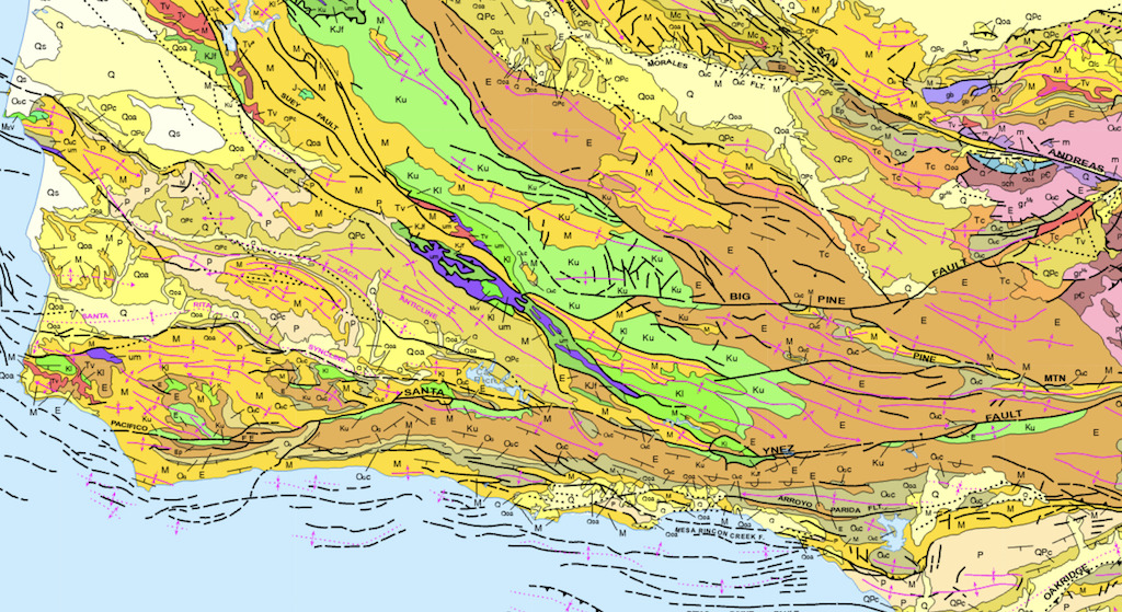
To understand earthquake hazards, we need to know where faults are and how they behave over time. We know a fault exists only if it has produced an earthquake or it has left a recognizable mark on the Earth's surface. Once a fault has been identified, the next step is to determine how it behaves. Landsat images have been used to map geologic faults and fracture zones.
When the time the first Landsat launched, scientists were still debating the science around the dynamic nature of the Earth’s crust. Data from Landsat’s Multispectral Scanner (MSS) provided global imagery of Earth’s land areas that supported the recently newly accepted discovered theory of plate tectonics over the previously debated theory of continental drift.
Early Example of Continental Drift Theory
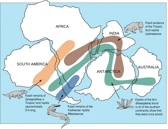
From maps of Earth, early Earth scientists noticed that the continents could fit together like puzzle pieces, and hypothesized that the existing continents were once part of a single landmass called Pangaea. These, along with geologic and fossil observations, inspired Alfred Wegener and colleagues to publish and promote the theory that continental landmasses ‘drifted’ across the Earth or the Theory of Continental Drift. But many other earth scientists did not accept this as it did not address the mechanism for why or how the continents moved over the millennia
Landsat Images supported the theory of Plate Techtonics
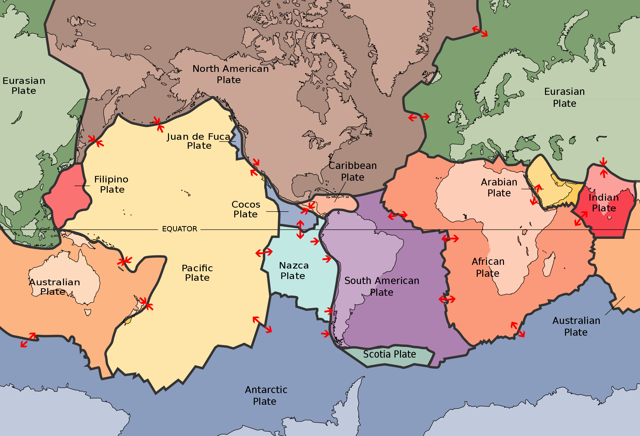
The science of plate tectonics filled in the missing pieces for ‘continental drift’ so Wegner was ‘right’ but for the ‘wrong reasons’ because he didn’t have the details about the geologic mechanisms of the Earth that we do now. Continents and vast undersea areas exist on giant plates of the Earth’s crust called tectonic plates. Tectonic activity - such as earthquakes and volcanoes - is the result of these solid plates of Earth’s crust moving above the molten and mobile mantle layer. Rift valleys, notably in East Africa, and fault lines like the San Andreas are visual examples of tectonic features which can also be easily seen from space. Early Landsat data provided global imagery that allowed geologists to identify fracture lines over large distances, expand probable fault maps, and ultimately support the science of plate tectonics.
Landsat data has served as the basis for a series of global tectonic activity maps, the first in 1977. Improving maps of geologic faults and fracture zones have helped with earthquake awareness and other geohazards such as landslide-prone areas.
The final is at: N 34° 37.ABC' W 120° 27.DEF
On the front door of the Pay Kiosk, there is an eleven-digit phone number of a security firm. Use this number to find the final coordinates.
A = the second digit
B = the fifth digit
C = the sixth digit minus the last digit
D = the number of zeros in the phone number
E = the number of distinct digits in the phone number
F = the third digit plus the fourth digit minus 10
The CHECKSUM is 36

You can validate your puzzle solution with certitude.