Austrian Summits - Gumma 2316m Traditional Cache
Austrian Summits - Gumma 2316m
-
Difficulty:
-

-
Terrain:
-

Size:  (regular)
Please note Use of geocaching.com services is subject to the terms and conditions
in our disclaimer.

| AUSTRIAN SUMMITS |
|
Diese Serie soll euch einige österreichische Berggipfel mit jeweils einer möglichen Anstiegsvariante näherbringen. |
|
The intention of this series is to present some Austrian summits and recommended ways to reach the respective summit. |
|
| GUMMA 2316 m |
|
Die Gumma ist einer der schönsten Aussichtspunkte im UNESCO Biosphärenpark Salzburger Lungau. Weit reicht der Blick vom Roteck hin zur Kreuzhöhe und zum Hocheck, um nur einige wenige zu nennen.
The Gumma is one of the most beautiful viewpoints in the UNESCO Biosphere Park Salzburg Lungau. The view stretches far, from the Roteck to the Kreuzhöhe and the Hocheck, to name just a few. |
|
| Topo und Profil |
 |
 |
|
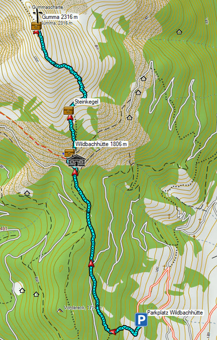
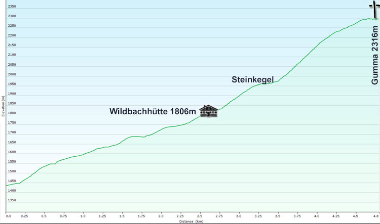
Parkplatz Wildbachhütte-Lessach / Parking Wildbachhütte 1420 m
Wildbachhütte / Wildbachhütte: 1806 m
Steinkegel / Stone cone formation: 1950 m
Gumma / Summit of Gumma: 2316 m
Höhenmeter Anstieg gesamt / Elevation Gain : 900 m
Höhenmeter Abstieg gesamt / Elevation Loss : 900 m
Strecke gesamt / Distance total: 10 km
|
|
Anreise Parkplatz Wildbachhütte / Approach parking Wildbachhütte: Du fährst mit deinem PKW Richtung Tamsweg und nach der Ortseinfahrt biegst du links ab Richtung St. Andrä/Wölting. In Wölting ist die Abzweigung Lessach. In Lessach angekommen und bevor du die Kirche erreichst, biegst du links ab Richtung Lessach Skilift und Wildbachhütte. Folge der Straße bis zum letzten Parkplatz, die Straße führt auf einer kleinen asphaltierten Strasse bei einem Bauernhof vorbei, bis der Einstieg der Wandertour beginnt.
You drive with your car in the direction of Tamsweg and after entering the town you turn left in the direction of St. Andrä/Wölting. In Wölting is the junction Lessach. Having arrived in Lessach and before reaching the church, turn left towards Lessach Skilift and Wildbachhütte. Follow the road until the last parking lot, the road leads on a small asphalt road past a farm until the start of the hiking tour.
|
|
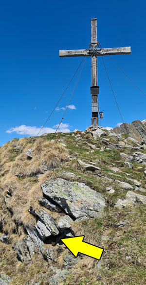
Kurze Tourenbeschreibung / a short description of the hike: Forstwege und Waldsteige führen bis zur Wildbachhütte und im Anschluss folgt man einen kleinen Steig Richtung Steinkegel. Diese Steinkegel sind heute Kraftplätze, wo man einen fantastischen Ausblick auf den Bezirkshauptort Tamsweg und Unterlungau hat. In den 50er und 60er Jahren des letzten Jahrhunderts errichtet, stellten und stellen sie noch heute eine besondere Art der Lawinenschutzverbauten dar. Der Weg führt dann ansteigend auf den Rücken der Gumma, wo ein wunderschönes Holzkreuz mit hervorragendem Ausblick wartet. Beim Anstieg hat man auch die Möglichkeit die Caches bei der Wildbachhütte und bei den Steinkegeln mitzunehmen.
Forest paths and forest roads lead from the parking area to the Wildbachhütte. From here you follow a small path towards the stone cones. These stone cones are today power places, where you have a fantastic view of the district capital Tamsweg and the Unterlungau. Built in the 50s and 60s of the last century, they represented and still represent a special type of avalanche protection structures. The trail then leads uphill to the summit of the Gumma, where a beautiful wooden cross with an excellent view awaits. During the climb you also have the opportunity to find the caches at the Wildbachhütte and at the stone cones.
Abstieg: wie Aufstieg.
Descent: like ascent.
|
|
Um euch zusätzlich zu motivieren, gibt es für 10 absolvierte AUSTRIAN SUMMITS ein eigenes Abzeichen, das ihr im öffentlichen Benutzerprofil führen könnt.
As additional motivation, everyone, who can log at least 10 AUSTRIAN SUMMIT Caches, will get an award for his profile.
EINFACH MIT EINER LISTE DER ABSOLVIERTEN AUSTRIAN SUMMITS ANFORDERN! / AWARD REQUESTS VIA OWNER'S PROFILE (PLEASE ADD LISTING OF CACHES LOGGED)!
|
|
| Cachebeschreibung / Spoiler |
|
Der Cachebehälter ist eine Lock&Lock-Dose, die ausreichend Platz für Tauschgegenstände bietet! In der Lock&Lock-Dose befindet sich das Logbuch, ein paar Stifte und eine Stash Note. Und im äußersten Notfall, wenn alles nass geworden ist, liegt nochmals ein Petling mit Reservelogbuch in der Box! Bringt sicherheitshalber immer einen eigenen Stift mit - danke!
The cache is a Lock&Lock box with Logbook, pencils and a Stash note inside. And, in addition, there is an emergency logbook available in a micro...!
Ursprünglicher Inhalt / Original Content
1 Logbuch (bitte nicht entfernen) / 1 logbook (please do not remove)
3 Stifte (bitte nicht entfernen) / 3 pens (please do not remove)
1 Petling mit Reservelogbuch und Stift (bitte nicht entfernen) / 1 micro with logbook and pencil (please do not remove)
|
 |
| Austrian Summits / so far... |
Viel Spass bei eurer Bergtour! / Enjoy Your Tour!

|
Additional Hints
(Decrypt)
fvrur Fcbvyre