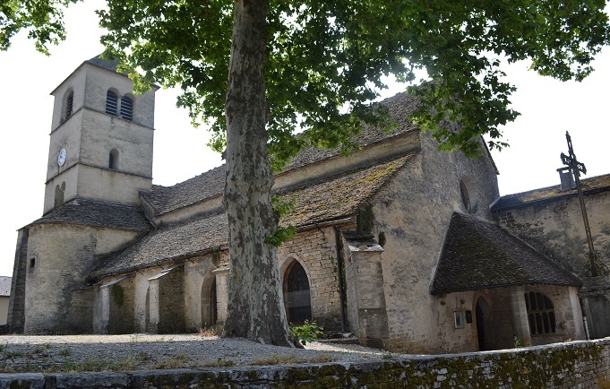
Le site
Haut-lieu du Jura, ce bourg historique dominant un éperon rocheux conserve les vestiges d’une abbaye de dames nobles, à côté d’une église paroissiale romane avec triple nef aux lourdes arcades. L’abbaye Notre-Dame aurait été fondée au 7e siècle par les bénédictines, puis sécularisée par les chanoinesses nobles du 13e siècle. Détruite après la Révolution, il ne reste rien de l’église abbatiale qui avait été construite vers 1165 avec trois nefs et portail sculpté. Les bâtiments abbatiaux qui occupent encore le bout de l’éperon datent du 16e au 18e siècle : hôtellerie, porterie, demeure de l'abbesse, maisons de chanoinesses, colombier.
L'église paroissiale Saint-Pierre fut fondée en 1134 jouxtant l’enceinte de l’abbaye. De cette époque elle conserve trois nefs à quatre travées, la travée droite du chœur et le clocher situé au nord du chœur. L’architecture de la nef est assez originale avec ses piliers polygonaux, grandes arcades en plein cintre, larges voûtes d’ogives carrées sur doubleaux et ses bas-côtés voûtés d’arêtes sur doubleaux. La travée de chœur, revoûtée, est munie d’arcatures murales sur colonnettes avec chapiteaux cubiques. Le clocher latéral présente un étage roman à baies géminées, sa partie supérieure ayant été refaite au 16e siècle. Sans oublier le toit recouvert de "laves", nom local pour un type de pierres plates. Mentionnons encore l’abside refaite au 18e siècle, le porche et sa chapelle Saint-Thiébaud du 16e siècle et le trésor des abbesses située sous le clocher.
Un peu de géologie ? Les Stylolithes
Selon les commentaires de la carte de géologie de Lons le Saunier, la partie supérieure du Kimmeridgien se distingue des autres strates sédimentaires des calcaires jurassiques par la fréquence des stylolithes.
► Définition
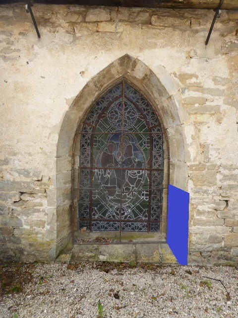
Les contreforts et chambranles des fen^tres de l'Eglise sont constitués de blocs de pierre calcaire taillés. Ces pierres portent des stigmates appelées stylolithes, qui sont les marques d'un passé mouvementé de la roche.
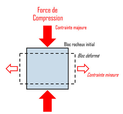
Le nom stylolithe (ou stylolite) vient des mots grecs stylos (pilier) et lithos (pierre). Un stylolithe est une structure géologique se formant lors de la déformation en compression d'une roche. Il consiste en une surface crénelée au niveau de laquelle la roche s'est dissoute sous des forces de compression importantes. Le stylolithe se présente sous la forme d'une ligne en dents de scie en plan de coupe transversal.
► Mécanismes de formation
Les stylolithes se forment principalement dans les roches sédimentaires carbonatées, et en particulier le calcaire. Lorsqu'une compression suffisamment importante est appliquée sur un bloc rocheux, celui-ci tend à se déformer. Sa dimension se réduit dans la direction de la contrainte maximale, et s'étend dans la direction perpendiculaire de plus petite contrainte.
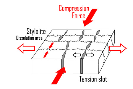
Une zone du bloc rocheux connaît alors une dissolution des particules silicatées et carbonatées. Un joint se forme à partir des résidus de la dissolution (argiles principalement, sulfures, matières organiques), et apparaissent plus sombres que la roche. Cette dissolution répond à la contrainte maximale subie, en permettant de réduire la taille de la roche dans la direction de cette contrainte. La surface stylolithique s'étend alors selon un plan perpendiculaire à la contrainte maximale appliquée sur la roche.
La forme irrégulière du stylolithe serait due à la présence de certains minéraux (pyrite, quartz) qui dévieraient les pics.
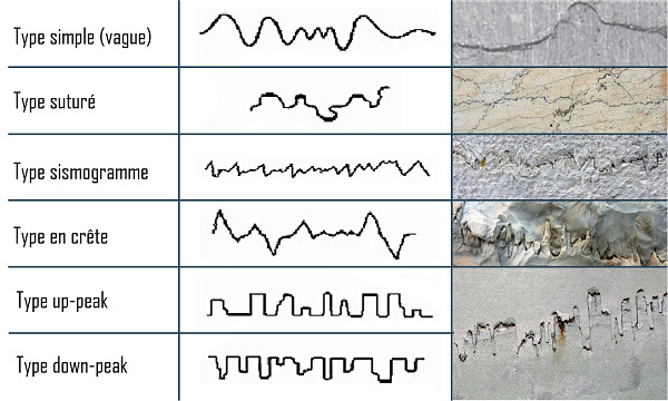
► Classification géométrique
La géométrie des stylolithes peut être variée selon les conditions de formation. Une classification fut établie par Park et Schot (1968) avec 6 types :
L'earthcache :

Pour loguer cette EarthCache, rendez-vous aux coordonnées, et répondez aux questions suivantes.
1 ► Observez les stylolithes sous la zone masquée de bleu. De quel type sont ces stylolithes ?
2 ► Que pouvez-vous observer d'autre sur cette pierre ?
3 ► Joignez à votre log une photographie permettant ou non de vous identifier (visage, GPS, pseudo, etc.) sur le site... mais sans montrer des éléments qui pourraient compromettre la résolution de la cache. Rien d'obligatoire mais très apprécié : Soyez créatif !
Rappels concernant les « EarthCaches » :
Il n’y a pas de contenant à rechercher aux coordonnées, ni de carnet à signer sur place. Il suffit de se rendre sur les lieux, de répondre aux questions ci-dessus, et de nous envoyer vos propositions de réponse soit via notre profil, soit la messagerie geocaching.com (Message Center).
Vous pouvez loguer un « Found it » sans attendre notre confirmation. Nous vous contacterons en cas de problème ou pour fournir d’éventuelles précisions.
Les « Found it » enregistrés sans envoi de réponses seront supprimés.
Bon Géocaching !
The place of interest
This historic village in the Jura region, which dominates a rocky spur, has preserved the remains of an abbey for noble ladies, next to a Romanesque parish church with a triple nave and heavy arcades. Notre-Dame Abbey was founded in the 7th century by the Benedictine nuns, then secularised by the noble canonesses in the 13th century. Destroyed after the Revolution, nothing remains of the abbey church which was built around 1165 with three naves and a sculpted portal. The abbey buildings that still occupy the end of the spur date from the 16th to the 18th century: hostelry, porter's house, abbess's residence, canonesses' houses, dovecote.
The parish church of Saint-Pierre was founded in 1134 next to the abbey's enclosure. From this period it has three naves with four bays, the right-hand bay of the choir and the bell tower situated to the north of the choir. The architecture of the nave is quite original with its polygonal pillars, large semi-circular arches, wide square ribbed vaults on doublets and its side aisles with groin vaults on doublets. The choir bay, which has been re-vaulted, is fitted with wall arches on columns with cubic capitals. The side bell tower has a Romanesque floor with geminated bays, the upper part having been rebuilt in the 16th century. We should also mention the apse, rebuilt in the 18th century, the porch and its 16th century Saint-Thiébaud chapel and the abbesses' treasure located under the bell tower.
Any geology ? The Styloliths
According to the comments of the geology map of Lons le Saunier, the upper part of the Kimmeridgian is distinguished from the other sedimentary strata of the Jurassic limestones by the frequency of styloliths.
► Définition
The upper tetragonal pillar of the fountain is made of limestone blocks. These stones present stigmatas called stylolites, which are the marks of the rock turbulent past.
The name stylolite comes from the Greek words stylos (pillar) and lithos (stone). A stylolite is a geological structure formed during the compressive deformation of a rock. It consists of a crenellated surface where the rock has dissolved under significant compressive forces. The stylolite is in the form of a sawtooth line in a transverse sectional plane.
► Mechanisms of formation
Stylolites are mainly formed in carbonate sedimentary rocks, and in particular limestone. When sufficient compression is applied to a rock block, it tends to deform. Its dimension decreases in the direction of the maximum stress, and extends in the perpendicular direction corresponding to the smallest stress.

An area of the stone then has dissolution of silicate and carbonate particles. A seal is formed from the residues of the solution (mainly clays, sulphides, organic matter), and appears darker than rock. This dissolution responds to the maximum stress applied, by making it possible to reduce the size of the rock in the direction of this stress. The stylolithic surface then extends along a plane perpendicular to the maximum stress applied to the rock.
The irregular shape of the stylolite would be due to the presence of some minerals (pyrite, quartz) which would deflect the peaks.
► Geometric classification
The geometry of the stylolites can be varied depending on the formation conditions. A classification was established by Park and Schot (1968) with 6 types :
The earthcache :
To log this EarthCache, go to the coordinates located close to the church, and answer the following questions.
1 ► Observe the styloliths underneath the blue masked area. What type are these styloliths?
2 ► what else can be observed on the stone ?
3 ► Join to your log a photo that identifies you (face, GPS, nickname, etc.) on the site... but without showing elements that may compromise the resolution of the cache. Be creative!
Reminders about the “EarthCaches”:
There is no container to look for nor a logbook to sign. Just go to the location, answer the questions above, and send us your proposals of answers either via our profile or Message Center.
You can log “Found it” without waiting for our validation. We will contact you in case of problems or to provide any clarification.
“Found it” logs saved without sending answers will be deleted.