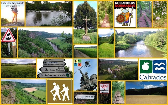
🌻🦅 Clécy - Suisse Normande 🧗🚶
Medium Trail = Longueur 13 km Km-Effort 18 km
Altitude max 160 m Dénivelé positif 374 m Altitude min 33 m

La barre des Rochers des Parcs
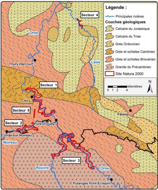
Dominant l’Orne de plus de 120m, la barre des Rochers des Parcs est formée par les Conglomérats et Grès pourprés de la base du Cambrien qui atteignent ici leur épaisseur maximale (100 à 120m). Les roches, des poudingues et des arkoses, sont dures et résistent bien à l’érosion ; elles forment des parois rocheuses très fréquentées par les amateurs d’escalade.
La barre de poudingues et arkoses des Rochers des Parcs souligne le rebord méridional du synclinal de la Zone bocaine. Elle domine une dépression creusée dans le flysch briovérien plissé et érodé, qui se trouve en position anticlinale. Ce dernier est recouvert par les alluvions récentes de l’Orne.
Au sommet de la crête rocheuse on peut facilement évaluer le pendage des bancs : 20 degrés vers le Nord. Ici, dans le flanc sud, la base du Cambrien a un pendage faible alors qu’au flanc nord les bancs sont très redressés. Le synclinal de la Zone bocaine est dissymétrique, comme les autres synclinaux paléozoïques du sud de Caen. Il s’est mis en place lors du plissement varisque (300Ma).
Arkoses et microconglomérats dans une voie d’escalade
Les arkoses renferment des passées de microconglomérats. Les éléments de quartz, très résistants, forment de multiples aspérités à la surface du rocher.
La vire étroite, qui est le point de départ d’une voie d’escalade, correspond à une surface de banc.
Conglomérat à dragées de quartz
Ce conglomérat peut être observé près du sommet de la barre rocheuse. Les graviers de quartz proviennent du démantèlement de filons de quartz qui parcouraient les granites de la chaîne cadomienne ; ils ont été répandus par les cours d’eau au pied des reliefs en voie d’aplanissement.
La couleur pourpre du conglomérat est due à la présence d’oxydes de fer (oligiste et goethite) formés en milieu continental et issus du lessivage du continent résultant de l'aplanissement de la chaîne cadomienne. Les galets sont souvent recouverts d’un mince enduit ferrugineux.
Les galets de quartz, blancs, se repèrent facilement. Les autres galets, sombres et de taille variable, se distinguent mal de la matrice : ils sont constitués de cornéennes et de grauwackes. Les cornéennes proviennent de l’auréole de métamorphisme des granites cadomiens et les grauwackes (grès immatures à fins débris de roches) sont issues du flysch briovérien non métamorphisé.
L’ensemble du matériel détritique provient de l’érosion des reliefs de la chaîne cadomienne (550 Ma).
Ce litage oblique observé dans les arkoses du sommet de l’escarpement témoigne du transport du matériel détritique par des courants. Ces arkoses sont d’origine fluviatile et les paléocourants sont orientés WSW-ENE.

The Rocks of the Parks bar
Dominating the Orne by more than 120m, the Rochers des Parcs bar is formed by purple Conglomerates and Sandstones from the Cambrian base, which here reach their maximum thickness (100 to 120m). The rocks, pudding and arkose, are hard and resist well to erosion; they form rock faces very popular with climbing enthusiasts.
The Rochers des Parcs pudding and arkose bar highlights the southern edge of the Bocaine Zone syncline. It dominates a depression carved out in the folded and eroded Brioverian flysch, which is in anticlinal position. The latter is covered by recent alluvium from the Orne.
At the top of the rocky ridge one can easily assess the dip of the banks: 20 degrees to the North. Here, in the southern flank, the Cambrian base has a shallow dip while on the northern flank the banks are very upright. The syncline of the Bocaine Zone is asymmetrical, like the other Paleozoic synclines south of Caen. It fell into place during the Variscus folding (300Ma).
Arkoses and microconglomerates in a climbing route
The arkoses contain past microconglomerates. The quartz elements, very resistant, form multiple asperities on the surface of the rock.
The narrow ledge, which is the starting point of a climbing route, corresponds to a bench surface.
Quartz dragee conglomerate
This conglomerate can be observed near the top of the rock ridge. The quartz gravels come from the dismantling of quartz veins which traversed the granites of the Cadomian range; they were spread by the rivers at the foot of the reliefs in process of leveling.
The purple color of the conglomerate is due to the presence of iron oxides (oligist and goethite) formed in a continental environment and resulting from the leaching of the continent resulting from the flattening of the Cadomian chain. The pebbles are often covered with a thin ferruginous coating.
The white quartz pebbles are easy to spot. The other pebbles, dark and of variable size, are difficult to distinguish from the matrix: they are made up of corneal and grauwackes. The corneas come from the metamorphic halo of Cadomian granites and the grauwackes (immature sandstones with fine rock debris) come from the unmetamorphosed Brioverian flysch.
All the detrital material comes from the erosion of the reliefs of the Cadomian range (550 Ma).
This oblique bedding observed in the arkoses at the top of the escarpment testifies to the transport of detrital material by currents. These arkoses are of fluvial origin and the paleocurrents are oriented WSW-ENE.
Pour loguer cette Earthcache
1. Rendez-vous aux coordonnées de la eartcache et découvrez le paysage tout autour de vous. Imaginez-vous il y a plusieurs milliers d'années. Il faut maintenant répondre à cette question en observant le pannonceau devant vous. Quelle formation géologique découvrez-vous sur votre gauche du site des rochers des parcs ?
2. Rendez-vous aux coordonnées N 48° 54.589' W 0° 27.293' Vous vous trouvez sur une roche, de quelle couleur est-elle et quelle en est la raison ?
3. Possibilité d'envoyer une ou plusiuers photos de vous ou de votre GPS sur ces rochers des parcs ?
4. Loguez cette cache "Found it" et envoyez-moi vos propositions de réponses soit via mon profil, soit via la messagerie geocaching.com (Message Center), et je vous contacterai en cas de problème. Sans réponse de notre part considérez que la cache est validée.
Belle découverte et bon geocaching.
To log this Earthcache
1. Go to the eartcache coordinates and discover the landscape all around you. Imagine yourself several thousand years ago. You must now answer this question by observing the sign in front of you. What geological formation do you discover on your left of the site of the rocks of the parks ?
2. Go to coordinates N 48 ° 54.589 'W 0 ° 27.293' You are on a rock, what color is it and what is the reason ?
3. Possibility to send one or more photos of you or your GPS on these rocks of the parks ?
4. Log in this "Found it" cache and send me your reply proposals either via my profile or via the geocaching.com message center, and I will contact you if there is a problem. Without any answer from us, consider that the cache is validated.
Beautiful discovery and good geocaching.
Source : DocOb Natura 2000 – Site FR2500091 « Vallée de l’Orne et ses affluents » CPIE des Collines normandes / CRPF de Normandie