LA CHAPELLE DU MONTAIGU
(Cette cache est une earthcache, il n'y a donc pas de contenant physique à trouver...)
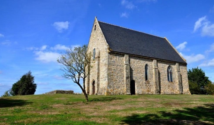
La chapelle, dédiée à l'Archange, fut construite en 1402 au sommet de la butte du Montaigu, pour permettre aux pélerins de la repérer. Selon son acte de fondation, elle a probablement succédé à une autre chapelle, en ruines, dédiée à St Michel de Tombelaine. Le chemin Montois allant du Mans au Mont Saint Michel traverse non loin la commune de Bais et passe à 3km au nord de la butte.
The chapel, dedicated to the Archangel, was built in 1402 at the top of the Montaigu hill, to allow pilgrims to spot it. According to its founding act, it probably succeeded another chapel, in ruins, dedicated to St Michel de Tombelaine. The Montois path going from Mans to Mont Saint Michel crosses the town of Bais not far and passes 3km north of the hill.
Un peu de géologie de cette butte ...
Le Massif Armoricain s'étend de la pointe de la Bretagne à la presqu'île du Cotentin et englobe une partie du Maine, de l'Anjou et de la Vendée. Il correspond à une ancienne chaîne de montagnes aplanie par une très forte érosion. Quelques reliefs existent néanmoins, le mont des Avaloirs (417m), point culminant du Massif Armoricain, ou encore des buttes granitiques comme le mont Rochard (363m) ou le Montaigu (290m).
La butte du Montaigu est composée d'une roche granitique (donc plutonique), classée dans la famille des granodiorites, roches composées de quartz, feldspaths et micas. Cette roche affleure rarement car elle est profondément altérée et forme un sable appelé arène. Cette arène granitique a d'ailleurs été exploitée par le passé sur le site de Montaigu (présence d'une petite carrière sur le flanc sud-est de la butte).
On remarque la présence de minéraux particuliers. En effet il y a dans la roche des petites veines quartzeuses contenant un peu d'étain et de tungstène. La chapelle a été construite avec le minerai de cette butte, et on retrouve ses caractéristiques en regardant les pierres de plus près.
Petit rappel :
Il existe trois familles de roches, les roches plutoniques (comme les granites), les roches sédimentaires (comme les tuffeaux ou les grès) et les roches métamorphiques (comme les marbres ou les schistes ardoisiers).
A little geology of this hill ...
The Massif Armoricain extends from the tip of Brittany to the Cotentin peninsula and includes part of Maine, Anjou and Vendée. It corresponds to an ancient mountain range flattened by very strong erosion. Some reliefs do exist, however, the Mont des Avaloirs (417m), the highest point of the Massif Armoricain, or granite mounds such as Mont Rochard (363m) or Montaigu (290m).

The Montaigu hillock is composed of a granitic rock (therefore plutonic), classified in the family of granodiorites, rocks composed of quartz, feldspars and mica. This rock rarely outcrops because it is deeply weathered and forms a sand called an arena. This granite arena has also been exploited in the past on the Montaigu site (presence of a small quarry on the south-eastern side of the hill).

We notice the presence of specific minerals. In fact, there are small quartz veins in the rock containing a little tin and tungsten. The chapel was built with the ore from this mound, and its characteristics can be found by looking at the stones more closely.

Little reminder :

There are three families of rocks, plutonic rocks (like granites), sedimentary rocks (like tufa or sandstones) and metamorphic rocks (like marbles or slate shales).
POUR POUVOIR LOGGER CETTE EARTHCACHE :
Il suffit de répondre aux questions très simples ci-dessous.
La lecture du descriptif concis et vos observations sur place devraient vous permettre de répondre facilement.
Le but est aussi de vous faire découvrir ce site Mayennais ainsi que son magnifique panorama, comme moi je l'ai, avec plaisir, découvert !
1. De quel type de roche granitique est faite la butte du Montaigu ?
2. Quels en sont les trois principaux composants ?
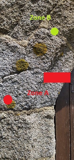
3. Observez les photos ci-dessous (il y a une vue large et une vue de plus près) de l'entrée de la chapelle.
----------> Quel type d'inclusion pouvez vous voir au niveau de la zone A ?
----------> Quel type de roche voyez vous au niveau de la zone B (Indice: on l'utilise pour les toitures !) ? A quelle famille appartient-elle ?
Vue large

Vue de près
4. OBLIGATOIRE : Faites une photo de vous ou de quoi que ce soit permettant d'identifier votre pseudo Geocaching devant la chapelle et postez la avec votre log.
Loguez cette cache "Found it" et envoyez-moi immédiatement vos propositions de réponses soit par mail, soit via la messagerie geocaching.com (Message Center), et je vous contacterai en cas de problème. Sans réponse ou la photo, j'invaliderai le log sans sommation.
TO BE ABLE TO LOG THIS EARTHCACHE:
Just answer the very simple questions below.
Reading the concise description and your observations on the spot should make it easy for you to respond.
The purpose is also to make you discover this Mayennais site as well as its magnificent panorama, as I have, with pleasure, discovered it!
1. What type of granite rock is the Butte du Montaigu made of?

2. What are the three main components?

3. Observe the photos below (there is a wide view and a closer view) of the entrance to the chapel.

----------> What kind of inclusion can you see in zone A?

----------> What type of rock do you see in zone B (Hint: we use it for roofs!) ? What family does it belong to?

Wide view
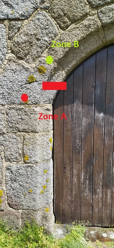
Close up view

4. MANDATORY: Take a photo of yourself or anything identifying your Geocaching nickname in front of the chapel and post it with your log.

Log "Found it" and immediately send me your suggested responses either by mail or by geocaching.com (Message Center), and I will contact you in the event of a problem. Without answer or the photo, I will invalidate the log without warning.