Vous vous engagez de votre propre initiative dans la recherche de cette cache à vos risques et périls. Je décline donc toute responsabilité en cas de problème.
Il s'agit d'une Earthcache, il n'y a pas de récipient à chercher.
Diorite à l'île de Batz
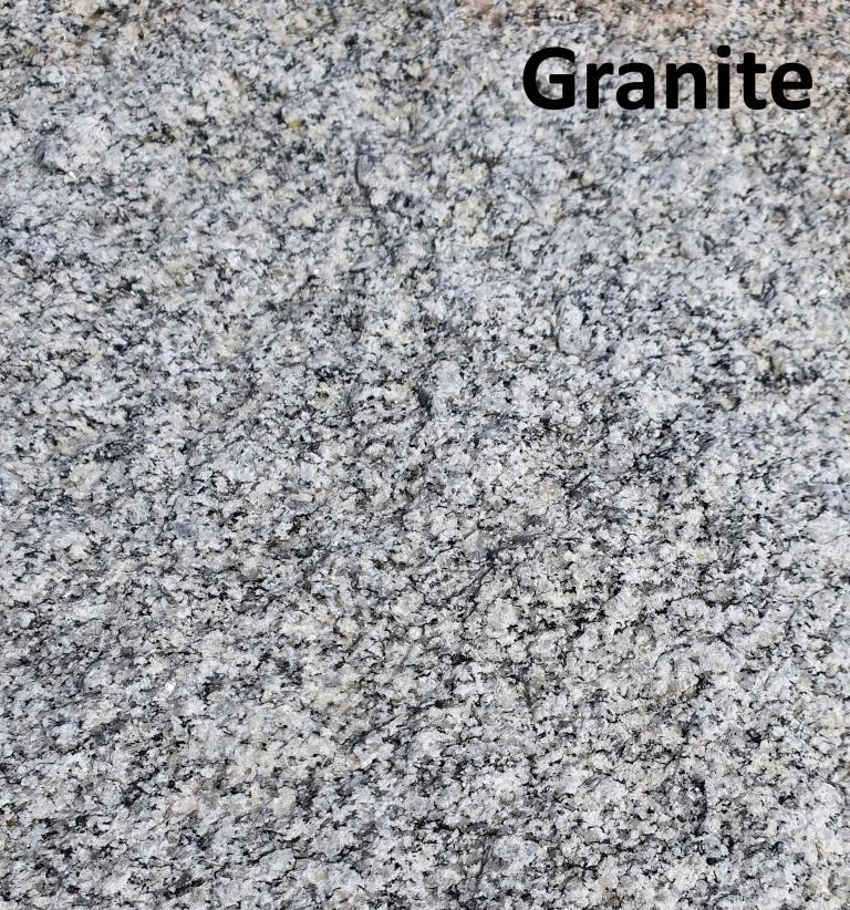
Granite de l’île de Batz
L’île de Batz est essentiellement constituée par un granite de teinte gris clair. Le grain est généralement fin mais il peut être légèrement porphyrique (c’est-à-dire avec des cristaux de feldspaths un peu plus grands que les autres, de l’ordre du centimètre). Certains faciès montrent essentiellement de la biotite, d’autres sont nettement à deux micas. Ainsi, selon la texture et la composition minéralogique, les variétés observées sont nombreuses pour un œil attentif. Le granite est très régulièrement recoupé pas des veines de pegmatites (grain plus gros, roche plus claire) à tourmaline (minéral noir en baguette), ce qui lui donne une image très caractéristique qui ne peut échapper au visiteur, dès les affleurements du littoral au débarcadère.
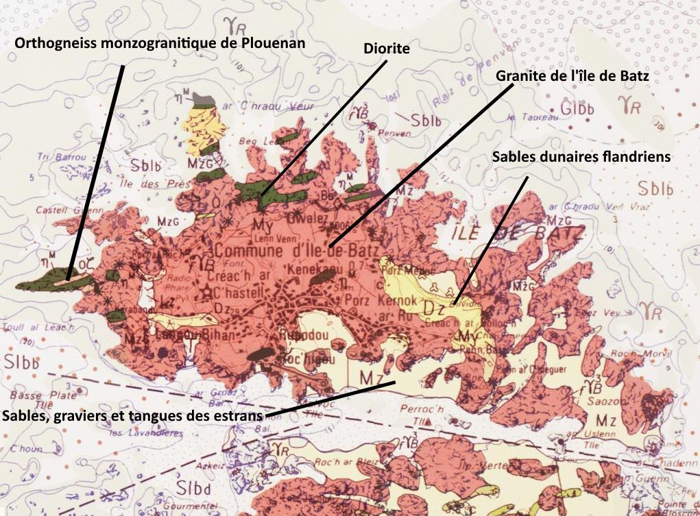
Le granite de l’île de Batz appartient au massif de Roscoff dont il constitue la bordure nord. Le granite est issu de la cristallisation en profondeur d’un magma qui a pour origine la fusion de la base de la croûte continentale vers 700°C et environ 100 km de profondeur. Sa mise en place est en relation avec l’orogenèse hercynienne, il y a environ 320 millions d’années, à la fin des temps primaires (ou Paléozoïque) qui a vu s’édifier une vaste chaîne de montagnes sur une grande partie de ce qui est aujourd’hui l’Europe. La Bretagne se situait alors au sein d’un vaste continent, à peu près au niveau de l’Equateur. Ce continent s’est ensuite disloqué tandis que l’Océan Atlantique s’ouvrait et que la Bretagne dérivait vers le nord. Depuis, durant des millions d’années, l’érosion a nivelé ces montagnes et porté le granite à l’affleurement sous des climats chauds et humides qui ont favorisé l’altération des roches. Plus récemment, l’érosion a dégagé les produits de cette altération, laissant les blocs de granite, rochers, îlots qui constituent le paysage de l’île et celui d’une grande partie du littoral du nord-Finistère, sur terre comme en mer, sur la plateforme à écueils due à un ennoyage marin.
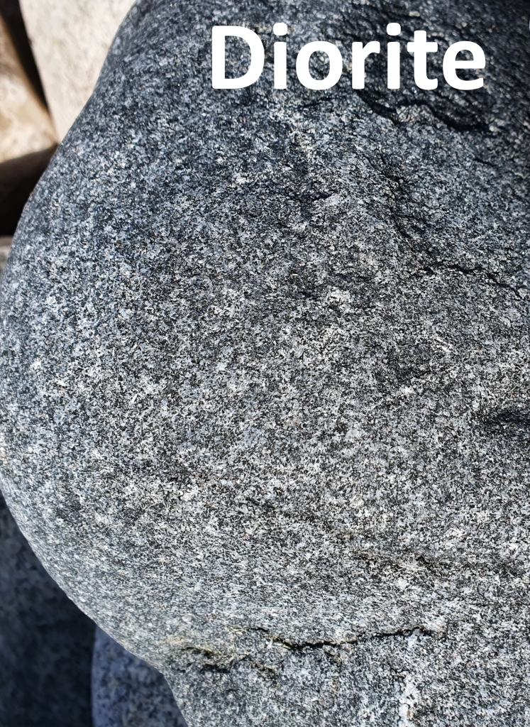
Diorite
Sur la côte nord de l’île et à la pointe ouest, on peut observer l’affleurement d’amas sombres dans l’estran et, plus visibles, de boules, souvent énormes, de teinte bleu-noir, offrant une desquamation en pelure d’oignon caractéristique. Le grain est fin à moyen, la minéralogie montre labrador (plagioclase), biotite et hornblende verte (amphibole).
Le magma dioritique est plus basique que le magma granitique, ce qui se manifeste notamment par une teneur en silice nettement plus faible (57% contre 72% l’île de Batz), par des teneurs en fer et magnésium, en chaux, plus élevées.
Sur ces affleurements de l’île de Batz, il est remarquable de pouvoir observer au contact entre granite et diorite des phénomènes de mélanges et d’hybridation entre les deux magmas qui témoignent de la contemporanéité de leur mise en place, il y a 320 millions d’années.
Mélanocrate et Leucocrate
Mélanocrate et leucocrate sont des adjectifs de coloration de la roche. Une roche leucocrate possède peu, entre 12,5 et 37,5% de ferromagnésiens. Elle est plutôt claire. Les minéraux ferromagnésiens sont sombres, ce sont principalement les micas, les amphiboles, les pyroxènes, les péridots. Par opposition une roche mélanocrate possède beaucoup, entre 62,5 et 87,5% de ferromagnésiens, donc elle est sombre.
Sources
Wikipedia
Une roche identitaire, Le Granite de l’île de Batz (Finistère)
https://www.geoportail.gouv.fr/donnees/cartes-geologiques
https://planet-terre.ens-lyon.fr/
Questions pour valider cette Earthcache :
- Identifiez les zones A et B de la Photo 1. Quelle est la différence de teinte de ces deux zones (laquelle des deux est leucocrate et laquelle est mélanocrate)?
- Sous quelle zone se situe le filon de diorite ?
- Une photo de vous ou d’un objet vous représentant sur le site.
Loguez cette cache "Found it" et envoyez-moi vos propositions de réponses soit via mon profil, soit via la messagerie geocaching.com (Message Center), et je vous contacterai en cas de problème. Les logs enregistrés sans réponses seront supprimés.
English version
You engage in the search for this cache on your own initiative at your own risk. I therefore decline all responsibility in the event of a problem.
This is an Earthcache, there is no container to look for.
Diorite on island of Batz
Granite from the island of Batz
The island of Batz is essentially made up of a light gray granite. The grain is generally fine, but it can be slightly porphyritic (that is, with feldspars crystals a little larger than the others, on the order of a centimeter). Some facies show predominantly biotite, others are distinctly two-mica. Thus, according to the texture and the mineralogical composition, the varieties observed are numerous for an attentive eye. The granite is very regularly cut by veins of pegmatites (larger grain, lighter rock) with tourmaline (black mineral in baguette), which gives it a very characteristic image which cannot escape the visitor, from the outcrops of the coast at landing stage.
The granite of the island of Batz belongs to the Roscoff massif, of which it constitutes the northern edge. Granite results from the deep crystallization of a magma that originates from the melting of the base of the continental crust at around 700 ° C and about 100 km deep. Its establishment is in connection with the Hercynian orogeny, about 320 million years ago, at the end of primary times (or Paleozoic) which saw the building of a vast mountain range over a large part of this which is Europe today. Brittany was then located within a vast continent, roughly at the level of the Equator. This continent then broke apart as the Atlantic Ocean opened up and Brittany drifted north. Since then, for millions of years, erosion has leveled these mountains and brought granite outcrop in hot, humid climates that have favored weathering of the rocks. More recently, erosion has released the products of this alteration, leaving the blocks of granite, rocks, islets that make up the landscape of the island and that of a large part of the coast of North Finistère, on land and at sea. , on the reef platform due to marine flooding.
Diorite
On the north coast of the island and at the western tip, we can observe the outcrop of dark clusters in the foreshore and, more visible, balls, often huge, blue-black in color, offering a peeling peel. characteristic onion. The grain is fine to medium, the mineralogy shows labrador (plagioclase), biotite and green hornblende (amphibole).
Dioritic magma is more basic than granitic magma, which is manifested in particular by a significantly lower silica content (57% against 72% on the island of Batz), by higher iron and magnesium and lime contents. .
On these outcrops of the island of Batz, it is remarkable to be able to observe in contact between granite and diorite phenomena of mixing and hybridization between the two magmas which testify to the contemporaneity of their establishment, there are 320 million years.
Melanocrates and Leucocrates
Melanocrates and Leucocrates are adjectives for rock coloring. A leucocratic rock has little, between 12.5 and 37.5% of ferromagnesium. It is rather clear. Ferromagnesian minerals are dark, they are mainly micas, amphiboles, pyroxenes, peridots. In contrast, a melanocratic rock has a lot, between 62.5 and 87.5% of ferromagnesium, so it is dark.
Questions to validate this Earthcache:
1. Identify areas A and B in Photo 1. What is the difference in hue of these two areas (which of the two is leucocratic and which is melanocratic)?
2. Under which zone is the diorite vein located?
3. A photo of you or an object representing you on the site.

Log this "Found it" cache and send me your suggested answers either via my profile or via geocaching.com (Message Center), and I will contact you in the event of a problem. Logs recorded without response will be deleted.