| |
|
|
 |
| Como Validar o teu Found? |
|
A coordenada publicada está no ponto de observação para as marmitas do Rio Coja, na ponte de Moinhos Pepim. Envia por mensagem ou email as respostas que pensas que estão correctas para validação.
1 - Tendo me conta uma linha imaginária orientada para Este deste a Ponte, olha para montante do ponto de observação e conta quantas Marmitas de Gigante consegues observar?
a) São entre 2 a 5?
b) São entre 5 a 10?
c) São mais que 10?
2 - Fazendo a mesma observação, mas agora para Jusante, quantas Marmitas de Gigante consegues observar?
a) São entre 2 a 5?
b) São entre 5 a 10?
c) são mais que 10?
3 - Do ponto de observação, as Marmitas, tanto para montante e jusante, são todas da mesma dimensão ou variam?
4 - O que observas no fundo das marmitas?
a- Nada
b- Pedras roladas (arredondadas)
c- troncos e paus partidos
d- outro material. Qual?
5- O processo de formação das marmitas de gigante está patente na página da cache. Contudo, a natureza gosta, de vez em quando, atirar-nos com algumas surpresas. Por esse motivo, olhando para o local desta EC, e depois de respondidas as perguntas, explica por palavras tuas como entendes que foram formadas as Marmitas de Gigante?
6 - OBRIGATÓRIO - Uma fotografia sua ou algo que o identifique na ponte sem mostrar o fenômeno que estamos apresentando para você!
|
|
| |
|
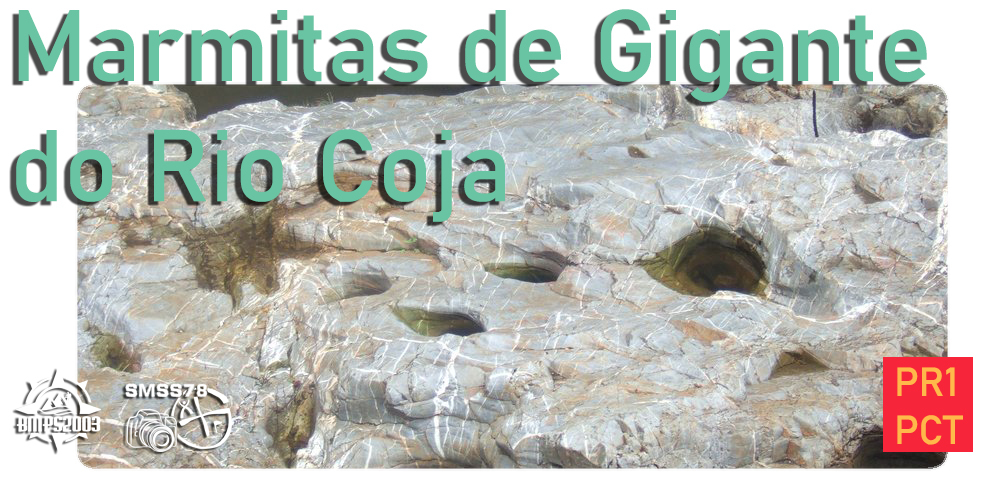
O Rio Coja é, ao longo de grande parte do seu percurso de cerca de 25km, um rio agitado, em luta constante contra o granito que há séculos desafia, com mais ou menos vigor, dependendo das estações do ano e da carga de pluviosidade que ora lhe dá mais ânimo, ora o serena. Nesta Ponte Rodoviária assistimos a uma divisão da sua atitude, afunilado e enérgico a montante, onde a água é mais enérgica, que se podem observar alguns exemplares notáveis de marmitas de Gigante.
|
|
| |
| Processo de formação das Marmitas de Gigante |
|
As Marmitas de Gigante são um daqueles fenómenos geológicos que se inserem num especto de tempo difícil de visualizar para os seres humanos.
Por isso mesmo, ao observá-las, não podemos deixar de pensar que são parte do curso de vida deste rio e que, a uma escala geológica, poderão ser apenas um efeito colateral, temporário, da sua principal missão: erodir e transportar todos esses sedimentos rochosos, ricos em minerais, até ás águas do Dão, um pouco mais adiante.
Tratam-se de depressões na rocha, de forma arredondada, que no seu fundo contêm material rochoso, seixos e areias. A sua formação começará em pontos de irregularidade do leito rochoso, que retêm no seu interior as tais areias e seixos transportados pela água e que gradualmente vão ficando aprisionados nestas cavidades. A acumulação deste material, com a constante passagem das águas, vai gerar um efeito de turbilhão, assim alimentando de energia estas pedras que passam a movimentar-se com uma trajetória circular.
Este constante movimento é o agente abrasivo responsável pelo gradual desgaste da rocha, tanto em largura como em profundidade, e que lhe confere a forma arredondada, mais ou menos irregular. Da mesma forma que os seixos desgastam a rocha, também a rocha desgasta os seixos, que antes de se transformarem em areias se vão tornando cada vez mais arredondados, sendo por isso comum encontrar pedras muito arredondadas ou quase esféricas em marmitas de gigante profundas.
|
|
| |
 |
| |
| PR1 PCT - Rota da Senhora da Ribeira |
|
A água é o elemento central da vida e ao longo dos caminho deste percurso não se consegue ficar indiferente ao papel que este líquido cristalino teve e tem na construção de uma rica e diversa paisagem rural, natural e patrimonial, moldada secularmente pelas mãos das gentes que estas terras permitiram nascer.
A Capela da Srª da Ribeira, uma de muitas com devoção a esta senhora erguida nesta região, constitui a materialização simbólica e espiritual do agradecimento desta terra ás águas que a animam.
O Dão e o Coja, numa união que aqui se pode admirar, são as artérias que movem as gentes de Moinhos de Pepim e as suas lavouras diárias. As vinhas estão onde quer que a vista alcance, ás vezes entre pomares, outras entre pequenos olivais, carvalhais e pinhais. As águas do Coja ora correm em pertos apressados, ora se abrem em calmarias. As antigas Azenhas continuam a vê-las passar.
O percurso parte da capela da Srª da Ribeira e não será coincidência a sua orientação privilegiada para o ponto de encontro do Coja com o Dão. Abençãdas as águas, o percurso segue pela tiroresca EM1360 até fletir para norte, subindo ligeira encosta por estrada asfaltada. Antes de virar a direita, por caminho rural, pode fazer um desvio para visita a um espaço artesanato local.
Segue-se uma jornada pelos campos de cultivo de Moinhos de Pepim e pelas suas cuidadas vinhas, sempre com a pontual presença e sombra de carvalhos maduros, até se atingir de novo uma estrada asfaltada. Aqui pode tomar a variante PR1.1, á direita, seguindo pelo asfalto, ou seguir pelo traçado mais longo, por caminhos rurais. Depois de percorrer uma pequena mata e descer uma encosta repleta de vinhas, é tempo de encontrar as águas do Coja, denunciadas pelo robusto som do seu embate no granito em percurso apertado. Deixa o seu leito virar para visitar Moinhos de Pepim e alcança em local com extraordinárias marmitas de gigante. Antes de encontrar o Rio Dão, mais uma vez se irá atravessar um pinhal e pela CM1360 até regressar mais uma vez a Srª da Ribeira
|
| Inicio |
Distancia |
Duração |
Tipo de percurso |
Desnivel Acumulado |
| Capela Srª Ribeira |
6,77 Km |
2 H 05 M |
Circular |
+ 205 M |
|
|

|
| How to validate your Found It? |
|
The published coordinate is at the observation point for the Coja River patholeses, on the Moinhos Pepim bridge. Send by message or email the answers that you think are correct for validation.
1 - Having an imaginary line oriented to the East from this to the Bridge, look upstream from the observation point and count how many Giant Patholes can you observe?
a) Are they between 2 to 5?
b) Are they between 5 to 10?
c) Are there more than 10?
2 - Making the same observation, but now for Downstream, how many Giant Pans can you observe?
a) Are they between 0 to 5?
b) Are they between 5 to 10?
c) Are there more than 10?
3 - From the observation point, are the Patholes, both upstream and downstream, of the same size or do they vary?
4 - What do you see at the bottom of the Patholes?
a- Nothing
b- Rolled stones (rounded)
c- trunks and broken sticks
d- other material. Which?
5- The giant pathole formation process is shown on the cache page. However, nature likes, from time to time, to throw us with some surprises. For this reason, looking at the location of this CE, and after answering the questions, explain in your own words how you understand that the Giant's Patholes were formed?
6 - MANDATORY - A photograph of you or something that identifies you on the bridge without showing the phenomenon that we are presenting to you!
|
| |
| Along most part of its 25km course, Coja River is a restless stream, in a constant struggle against the granite which it challenges for centuries, depending on the year´s seasons and on the rainfall level whicg will either rouse or sooth it. At this road bridge we can just see the difference in its behaviour: upstream funneled and vibrant, quieter and open downstream. It is precisely upstream, where the water is stronger, that some remarkable specimen of giant´s kettles can be observed. |
| |
| Giant´s Kettles Formation Process |
|
Giant´s Kettles are on of those geologic phenomena located in a tima spectrum difficult to imagine by human beings. Thus, when observing them we can rightly ascertain that they are part of life´s course of this river and that in a geologic scale, they may only be a secondary and transient effect of its ultimate mission - to erode and transport all these rocky and mineral enrichned debris a little futher to Dão river waters.
They are round shaped potholes occurring in the rocks, wich in their bottom contain rock material, pebbles and sand. Its formation seems to begin in uneven points of the rock stream bottom witch encloses the mentioned sands and pebbles transported by water and wicth encloses the mensioned sands and pebbles transported by water and which are gradually being trapped within those patholes. The accretion of this material together with the constant water flow will originate a swirling effect fuelling those stones which will move in circular way.
The constant movement is the abrasive agent responsible for the rock´s progressive erosion in its diameter as well as depth, which gives it the more or less uneven rounded shape. In the same way as the pebbles abrade the rock, the rock itself abrades the pebbles, wihich before their transformation into sand become increasingly round; it is thus usual to find specially round or almost spherical stones in deeper giant´s kettles.
|
| |
| Starting Point |
Distance |
Durantion |
Type Of Path |
Cumulative Gap |
| Srª Ribeira Chapel |
6,77 Km |
2 H 05 M |
Circular |
+ 205 M |
|
|
| |
|
| |
| PR1 PCT - Route of Senhora da Ribeira |
|
Water is life´s core element. Along the paths of this route we cannot ignore the role played presently and in the past by this crystal clear liquid in the building of a rich and varied rural, natural and patrimonial landscape, shaped throughout the centuries by people born in these lands. The Srª da Ribeira Chapel, on of the many present in this region with devotion to holy lady, represents the symbolic and spiritual embodiment of the gratitude of this land to the waters running throught it.
Rivers Dão and Coja, whose joining is here to be viewed, are the router which inspire people from Moinhos de Pepim and its daily Labours. Vineyards are everywhere as far as the eye can see, sometimes amongst orchards, other amongst small olive groves, oak and pine forest. Coja River waters can flow either hasty throught narrow valleys or opening in a slumbering mood. The old watermills keep watching them pass.
The router starts at Srª da Ribeira Chapel and follows a special orientation towards the meeting point of rivers Coja and Dão which isn´t certainly a sheer coincidence. Once the waters and blessed, the route follows picturesque EM1360 till turn north, mounting the smooth slope throught a paved road. Before turning right on a rural path, you may take a detour to visit a local craft shop.
The route follows then thought the farming lands of Moinhos de Pepim as well as though the well cared vineyards, with the constant presence and shadow of grown oaks, till reaching once again a paved road. Here you may take the variant PR1.1, on the right, following the paved road, or take the longest route by rural path. After crossing a small wood and heading down a vineyards covered slope, you will find the coja waters, betrayed by the heavy sound when striking granite in a narrow path. You leave its riverbed to visit Moinhos de Pepim and once again return to it in a location with extraordinary Giant Kettles. Before finding the Dão River once again, you will cross a Pine wood and throught CM1360 you will again reach Srª da Ribeira
|
| |
|

|

|
 |
| |