 Les affleurements rocheux exposés entre goémons et verdure sur la rive sud du petit chantier naval de La Landriais sont constitués de grès fins métamorphisés à quartz et biotite, de métapélites et de gneiss à deux micas.
Leur géométrie apparaît irrégulière et il faut observer la roche de près pour en découvrir la cause : des charnières de plis dont l'allure variée est révélatrice de deux épisodes de déformations. Le premier est responsable de plis très sérrés, aux flancs parallèles et subhorizontaux. Le second se marque par des plis à flancs redressés. L'ensemble de ces structures témoigne d'un épisode de raccourcissement important.
 The rocky outcrops exposed between seaweed and greenery on the south shore of the small shipyard of La Landriais consist of fine sandstone metamorphosed with quartz and biotite, metapelites and two-mica gneisses.
Their geometry appears irregular and you have to observe the rock closely to discover the cause: fold hinges whose varied appearance is indicative of two episodes of deformation. The first is responsible for very tight folds, with parallel and subhorizontal sides. The second is marked by folds with straightened sides. All of these structures testify to a significant shortening episode.
Source : Curiosités géologiques de la Baie de St Brieuc au Mont St Michel - Bernard Le Gall Martial Caroff - brgméditions.
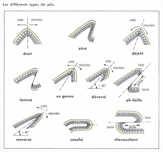
Un pli est une structure courbe due à une déformation ductile de la roche.
Le cas le plus simple est le pli de roches sédimentaires dont les lits sont planaires et horizontaux avant le plissement.
Lorsque des couches de terrain de l’écorce terrestre sont soumises à des contraintes tectoniques, ces roches vont, à la longue, se déformer. Les déformations sont d’abord souples, non cassantes. On obtient alors des ondulations de terrain appelées plis. On parle de plissement des roches.
Si les contraintes se poursuivent, les déformations vont devenir cassantes : la roche se brise. On obtient alors des failles. Selon la plasticité de la roche, l’apparition de failles interviendra plus ou moins vite.
Un pli peut être droit, déjeté ou couché, en fonction de son axe central (vertical pour un pli droit, devient de plus en plus horizontal).
Lorsque les contraintes provoquent une rupture des couches, on obtient un pli-faille , La couche de roche se trouve alors scindée en deux parties.
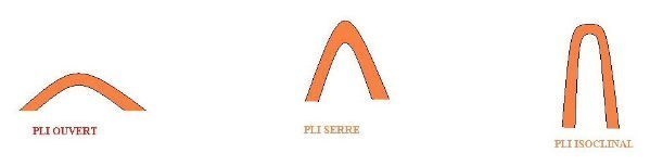
En fonction de l'angle formé par les flancs du pli, le pli se dit ouvert, serré ou isoclinal (angle de plus en plus aigu)
A fold is a curved structure due to a ductile deformation of the rock.
The simplest case is the fold of sedimentary rocks whose beds are planar and horizontal before folding.
When land layers of the Earth's crust are subjected to tectonic stresses, these rocks will eventually deform. The deformations are initially soft, not brittle. We then obtain undulations of ground called folds. We are talking about folding rocks.
If the constraints continue, the deformations will become brittle: the rock breaks. We then obtain faults. Depending on the plasticity of the rock, the appearance of faults will intervene more or less quickly.
A fold can be straight, out of focus or lying down, depending on its central axis (vertical for a right fold, becomes more and more horizontal).
When the stresses cause a rupture of the layers, one obtains a fold-fault, the layer of rock is then split into two parts.
Depending on the angle formed by the flanks of the fold, the fold is said to be open, tight or isoclinal (angle increasingly acute)
!!! ATTENTION CACHE INACCESSIBLE A MAREE HAUTE !!!
!!! WARNING EARTHCACHE INACCESSIBLE HIGH TIDE !!!
Avant de vous y aventurer, consulter l'horaire des marées sur la Rance :
Before you go, check the tide schedule on the Rance river :
Horaires des marées en Rance
Questions pour valider cette earthcache :
D'après vos observations et à l'aide du desciptif,
Questions to validate this earthcache:
Based on your observations and using the description :
Question 0
Joindre à votre log (pas à vos réponses) une photo de votre GPS, votre GC perso ou tout autre objet de geocaching aux coordonnées la cache (sans dévoiler les réponses !)
Les photos de paysage ou capture d'écran de votre position ne permettent pas de valider cette condition de log.
Cette tâche est obligatoire et autorisée par les guidelines mises à jour en juin 2019.
Attach to your log (not with your answers) a photo of your GPS, your personal GC or any other geocaching object at the posted coordinates (without spoilers !)
The simple photos of the landscape or screenshot of your position do not validate this log condition.
This task is mandatory and allowed by the guidelines updated in june 2019.
Question 1
Quel type de pli observe-t-on dans la zone verte ? Précisez s'il est ouvert ou serré ?
What type of fold do we see in the green area? Specify if it is open or tight?
Question 2
Quel type de pli observe-t-on dans la zone jaune ? Précisez s'il est ouvert ou serré ?
What type of fold do we see in the yellow area? Specify if it is open or tight?
Question 3
Quel type de pli observe-t-on dans la zone rouge ? Quelle est la nature de l'élément qui est plissé ?
What type of fold do we see in the red area? What is the nature of the item that is pleated?
Envoyez-moi vos propositions de réponses soit via mon profil, soit via la messagerie geocaching.com (Message Center) PUIS loguez cette cache "Found it", je vous contacterai en cas de problème.
Assurez vous de répondre à TOUTES les questions ! La condition principale pour loguer une Earthcache étant de répondre aux questions posées dans le descriptif, tout log "Found it" enregistré sans envoi préalable de vos propositions de réponses sera supprimé. Il en sera de même pour les logs enregistrés sans la photo requise.
Send me your proposals for answers either via my profile or via the geocaching.com messaging (Message Center) THEN log this cache "Found it", I will contact you in case of problem.
Make sure to answer ALL questions ! The main condition to log an Earthcache is to answer the questions asked in the description, any log "Found it" registered without prior submission of your proposals of answers will be deleted. It will be the same for logs saved without the required photo.