
La Earthcache / The Earthcache
La Camargue, vaste plaine deltaïque de 150,000 hectares, est un des territoires français métropolitains les plus jeunes et est toujours en évolution.
► La Camargue, ultime don du Rhône
Avec un relief ne dépassant jamais 6 mètres d'altitudes, c'est une plaine basse subhorizontale avec une pente moyenne de 0,17%.
Au Quaternaire, un affaissement régional détourne le cours du Rhône vers la région d'Arles.
A partir d'un vaste paléo-golfe, le fleuve va petit à petit se construire un nouveau delta.

C'est l'important charriage de sédiments par le Rhône (21 millions de m3 par an) et les crues qui sont à l'origine de dépôts successifs de sédiments et du comblement du paléo-golfe.
Cette épaisseur de sédiments dépasse par endroit les 1500 mètres !
► Texture et devenir d'une formation sédimentaire fluviale
La texture d'une formation détritique d'origine fluviale dépend de la classe granulométrique de ces sédiments (taille moyen des sédiments).

Selon cette texture, la formation sera plus ou moins perméable. Très filtrant dans le cas d'une texture sableuse, elle va être imperméable si la texture est argileuse.
Cela influence la lixiviation des minéraux, dont le fer. Facilement lessivé dans des sédiments sableux, le fer stagne dans l'argile et s'oxyde, donnant une coloration rouge.
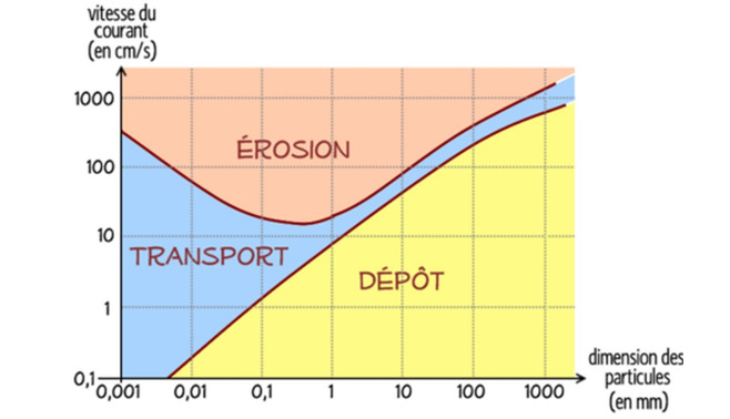
Dans le cadre d'un transport fluvial, il est possible de caractériser les conditions de dépôt en fonction de la taille des sédiments grâce au diagramme de Hjuström.
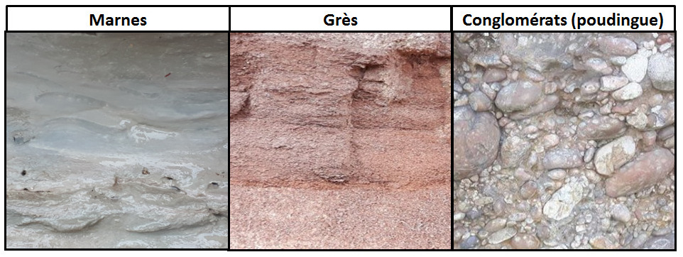
En cas de diagenèse (transformation des sédiments en roche), la nature des roches sédimentaires obtenues dépend de la taille de ces sédiments :
- Les sédiments argileux et limoneux donneront des marnes, tendres et lisses au toucher.
- Les sables donneront des grès (quartziques ou calcaires).
- Les blocs de plus de 2 mm donneront des conglomérats (poudingues si sédiments fluviaux).
► Tests de détermination d'une texture
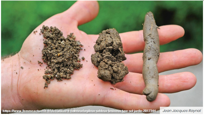
En plus de l'évaluation à l'œil nu de la classe granulométrique des sédiments, il est également possible de faire des tests complémentaires :
- Test du toucher : plus la terre est collante et les mains difficiles à laver, plus la terre est argileuse. Si on ressent beaucoup de « grains » sous les doigts et qu’elle colle peu, alors la terre est peu argileuse.
– Test du boudin : On fait rouler la boule entre les mains jusqu’à obtenir peu à peu un cordon et on surveille à quel diamètre ce cordon casse. Plus le cordon est fin, plus il y a d’argile.
► Texture et sécheresse
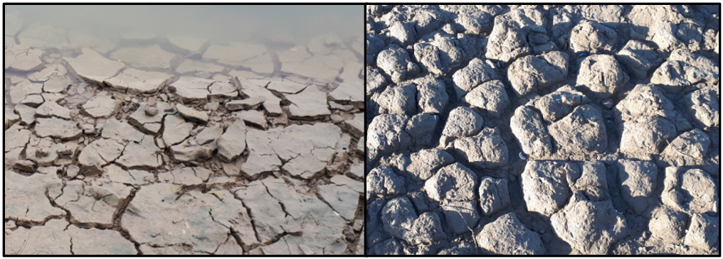
La sensibilité d'un sol à la sécheresse est fortement liée à sa texture. Plus les sédiments sont fins, plus la sensibilité du sol au retrait de l'eau par évaporation est importante.
Dans le cas les plus extrêmes, il se met en place des fentes de dessiccation ou mudcrack.
C'est une structure formée lorsqu'un sédiment argileux se dessèche et se contracte du fait de la réduction de sa teneur en eau, donnant des fissures formant un réseau polygonal interconnecté.
Quand ces polygones se retrouvent longtemps à l'air libre, ils s'altèrent sous forme de dômes donnant une surface en coussins.
The Camargue, a vast deltaic plain of 150,000 hectares, is one of the youngest metropolitan French territories and is still evolving.
► The Camargue, the Rhône's ultimate gift
With a relief never exceeding 6 meters in altitude, it is a low subhorizontal plain with an average slope of 0.17%.
In the Quaternary, a regional subsidence diverts the course of the Rhône towards the region of Arles.
From a vast paleo-gulf, the river will gradually build a new delta.
It is the significant load of sediments by the Rhône (21 million m3 per year) and the floods which are at the origin of successive deposits of sediments and the filling of the paleo-gulf.
This thickness of sediment in places exceeds 1500 meters!
► Texture and fate of a fluvial sedimentary formation
The texture of a detrital formation of fluvial origin depends on the particle size class of these sediments (average size of the sediments) - Table in french description.
Depending on this texture, the formation will be more or less permeable. Very filtering in the case of a sandy texture, it will be waterproof if the texture is clay.
This influences the leaching of minerals, including iron. Easily leached in sandy sediments, iron stagnates in the clay and oxidizes, giving a red color.
In the context of fluvial transport, it is possible to characterize the deposition conditions as a function of the size of the sediments using the Hjuström diagram - diagram in french description.
In the case of diagenesis (transformation of sediments into rock), the nature of the sedimentary rocks obtained depends on the size of these sediments:
- The clayey and silty sediments will give marls, soft and smooth to the touch.
- The sands will give sandstones (quartz or limestone).
- Blocks of more than 2 mm will give conglomerates (pudding if fluvial sediments).
► Tests to determine a texture
In addition to the naked eye evaluation of the particle size class of the sediments, it is also possible to carry out additional tests:
- Touch test: the more the earth is sticky and the hands difficult to wash, the more clayey the earth. If you feel a lot of "grains" under your fingers and it sticks out little, then the soil is not very clayey.
- Test of the sausage: We roll the ball between the hands until gradually obtaining a bead and we monitor the diameter of the bead breaks. The thinner the bead, the more clay.
► Texture and dryness
The sensitivity of a soil to drought is strongly linked to its texture. The finer the sediment, the greater the sensitivity of the soil to water removal by evaporation.
In the most extreme cases, it sets up desiccation slots or mudcrack.
It is a structure formed when a clay sediment dries up and contracts due to the reduction in its water content, giving rise to cracks forming an interconnected polygonal network.
When these polygons are left in the open air for a long time, they alter in the form of domes giving a cushioned surface.
► Sources bibliographiques / Bibliographical sources
Les Questions / The Questions
Questions pour valider :"La Camargue aux Saintes-Maries-de-la-Mer"
Questions to validate: "The Camargue in Saintes-Maries-de-la-Mer"
Point 1 : N 43° 27.702 E 004° 26.921
Vous voici sur une portion surélevée s'enfonçant dans l'étang de Monro. Observez la zone à gauche du chemin en venant du parking (photo WP1).
You are now on an elevated portion plunging into the pond of Monro. Observe the area to the left of the path coming from the car park (photo WP1).
- Question 1 : Prélevez des sédiments et réalisez les tests du toucher et du boudin. Quelle est la texture du sol ? En considérant le diagramme de Hjuström, la taille des sédiments vous semble t-elle cohérente avec la topographie du delta du Rhône ?
- Question 1: Collect sediment and carry out the feel and roll tests. What is the texture of the soil? Considering the Hjuström diagram, does the size of the sediments seem to you to be consistent with the topography of the Rhône delta?
- Question 2 : En considérant vos réponses à la question 1, en cas de diagenèse des formations alluviales de cette région de la Camargue, quelle roche obtiendrions-nous ?
- Question 2: Considering your answers to question 1, in case of diagenesis of the alluvial formations in this region of the Camargue, what rock would we obtain?
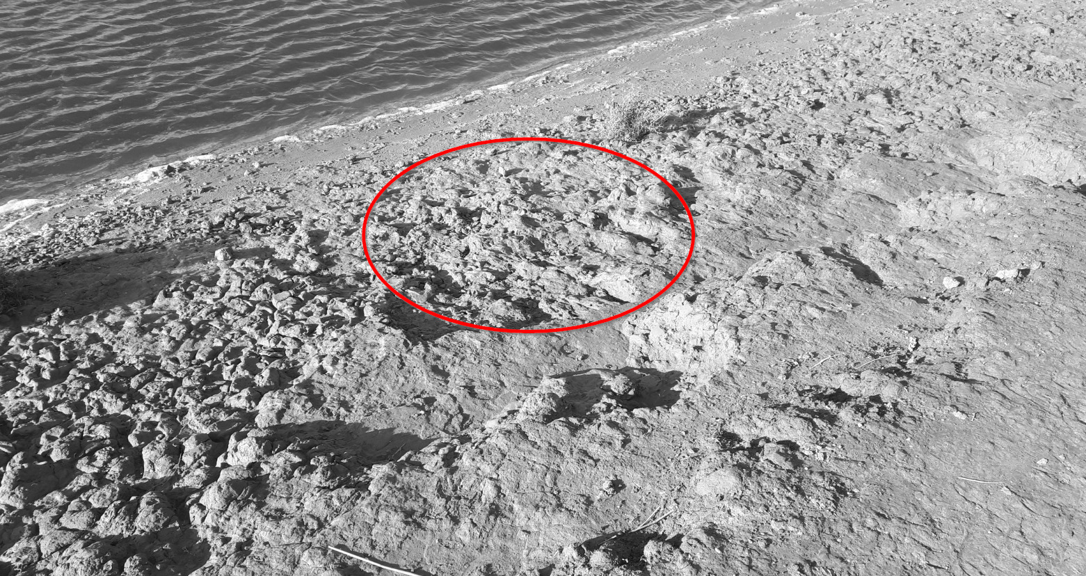
- Question 3 : Les sédiments au niveau de la zone entourée en rouge présente une coloration particulière. Quelle est cette couleur et son origine ?
- Question 3: The sediments in the area circled in red show a particular coloring. What is this color and its origin?
Point 2 (possible pour la photo) : N 43° 27.790 E 004° 26.961
Remontez la presqu'île jusqu'à son extrémité (WP2 ou avant si l'eau a monté).
Go up the peninsula to its end (WP2 or before if the water has risen).
- Question 4 : Prenez une photo de vous ou d'un élément vous appartenant avec les étangs de Camargue (et peut être des flamands roses) en arrière plan.
Cette photo devra au choix nous être transmise avec les réponses ou être ajoutée à votre log.
-Question 4 : Take a picture of yourself or an item you own with the Camargue ponds (and possibly flamingos) in the background.
This photo must either be sent to us with the answers or added to your log.
Point 3 : N 43° 27.473 E 004° 26.748
En retournant vers le parking, observez le sol côté douve depuis le chemin (photo WP3).
After going along the edge of the marsh, go back to the water's edge (photo WP2).
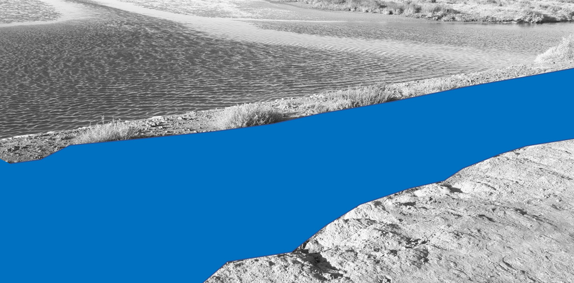
- Question 5 : Décrivez les formes que prend le sol sous la zone bleue. Quel phénomène est à l'origine de ces formes ? Cela confirme t-il la texture obtenue au WP1 ?
- Question 5 : Describe the shapes the soil takes under the blue area. What phenomenon is at the origin of these forms? Does this confirm the texture obtained at WP1?
Vous pouvez vous loguer sans attendre notre confirmation,
mais vous devez nous envoyer les réponses en même temps soit par mail via notre profil (
fafahakkai), soit via la messagerie geocaching.com (Message Center).
S'il y a des problèmes avec vos réponses nous vous en ferons part.
Les logs enregistrés sans réponses seront supprimés.
You can log this cache without waiting for our confirmation, but you must send us the answers at the same time, by e-mail via our profile (fafahakkai) or by the system of Message Center of geocaching.com.
If there is a problem with your answers we will notify you. The logs recorded without answers will be deleted.
Rappel concernant les « Earthcaches »: Il n'y a pas de conteneur à rechercher ni de logbook à renseigner. Il suffit de se rendre sur les lieux, de répondre aux questions ci-dessus et de nous renvoyer les réponses.
Reminder concerning "Earthcaches": there is neither a container to look for nor a logbook to sign. One need only go to the location, answer to the differents questions and send us the answers.