Welcome to Sun Moon Lake!
歡迎來到日月潭!

In this Earth Cache, you will learn about crustal foldings, fractured faults, and water erosion, and how these forces of Mother Nature helped shape and maintain the largest natural lake in all Taiwan — Sun Moon Lake! And after you answer the task questions and complete all your Geological Studies and Observations (which can all be found at the bottom of this page), you can log a “Found It!” for this Earth Cache. I hope you enjoy! Let’s get going and see what these forces of Mother Nature are all about here at Sun Moon Lake . . .
這個地質寶可以學習地殼褶曲、斷層、和侵蝕作用,還可以瞭解地球如何塑造台灣最大的自然湖泊-日月潭。完成所有的地質研究與觀察和回答完任務後(頁面最下方),可以線上登錄這個地質寶。希望你喜歡!一起來日月潭看看地球的作用吧。
|
Introduction to How Sun Moon Lake was Formed
To understand exactly how Sun Moon Lake came into existence, we must first understand a little bit about the dynamics of the Earth's surface.
The Earth’s surface is composed of tectonic plates that are constantly moving. As the plates move relative to one another, they experience different types of forces. One kind of force is referred to as tension. Tension occurs when the plates are pulled apart, causing the crust to either get longer or break apart. Tension forces can cause volcanic islands or mid-oceanic ridges to form.
Another kind of force is referred to as compression. Compression occurs when the plates are pushed toward each other causing them to crash. Compression forces can cause mountains to form or earthquakes to occur depending on how the Earth’s crust reacts to the force.
When the Earth’s crust is pushed together via compression forces, it can experience geological processes called folding and faulting.
Folding occurs when the Earth’s crust bends away from a flat surface. A bend upward results in an anticline and a bend downward results in a syncline. However, whether the resulting phenomena is an anticline or syncline is dependent upon what kinds of rocks and minerals are present in that area.
Faulting happens when the Earth’s crust completely breaks and slides past each other.
Whether the Earth’s crust experiences a fold or fault will depend on the material it is made out of in that area.
A fold is more likely to happen with flexible material and it is what cause mountains to form, whereas a fault will happen with more brittle material and is what causes earthquakes to occur.
Below is a chart outlining different kinds of Crustal Folds:

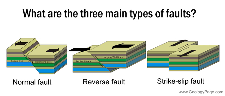
Below is a chart outlining different Faults:
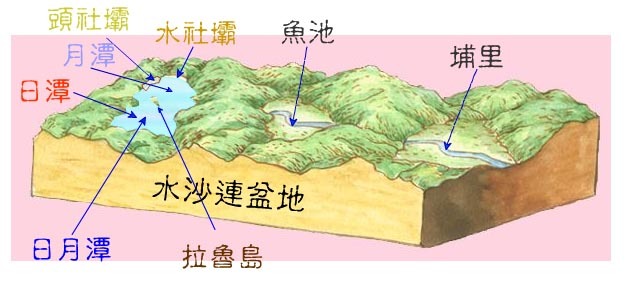
Below is a 3D diagram of Sun Moon Lake and its surrounding area where you can see where foldings and/or faults occurred:
介紹日月潭如何形成
為了瞭解日月潭如何出現的,我們得先瞭解一些地球表面的變動。
地球表面由不斷移動的板塊所組成,當這些板塊與其他板塊接觸的時候,會出現不同的動力作用。其中一種動力作用為分離(tension),當板塊被拉開的時候,會造成板塊變得更長或是裂開,分離板塊邊緣會出現火山島、海洋中洋脊。 另一種動力作用為聚合(compression),聚合作用發生於板塊互相擠壓造成碰撞,聚合板塊邊緣依地殼對這股力量的反應,可能會產生山脈或地震。
當地殼被擠壓時,會出現一些地質現象,像是褶曲與斷層。.
褶曲(Folding)是指地殼表面從平坦變得彎曲,向上彎曲會產生背斜(anticline),向下彎曲則會產生向斜(syncline),不過,會產生背斜還是向斜,取決於那個區域內的岩石與礦物。
斷層(Fault)是指地殼完全裂開與滑動。
地殼會出現褶曲或是斷層,則取決於那個區域由什麼礦物所組成。
褶曲比較容易發生於具有彈性的礦物,也是形成山脈的原因,而斷層則比較容易發生於較脆的礦物,也是發生地震的原因。
下方圖表為不同種類的地殼褶曲::
單斜(Monocline)- 單面傾斜
向斜(Sycline)- 向下褶曲形成U型
背斜(Anticline)- 向上褶曲形成n型
倒轉褶曲(Overtuned fold)- 與背斜相似,不過往一邊傾倒
逆掩褶曲(Overthrust fold)- 當倒轉褶曲完全倒向一端,整個褶曲倒在那一端岩層的上方。
下方圖示為不同的斷層類型:
分離力量產生正斷層,聚合力量產生逆斷層。
下方是日月潭3D圖示,可以看到周遭區域的斷層與褶曲位置。
|
Now that we have gone over the geological processes that helped form the area where Sun Moon Lake now sits, we need to go into the geological makeup of Sun Moon Lake to try and understand exactly what forces of Mother Nature were responsible for Sun Moon Lakes shape and why Sun Moon Lake is the only lake in the area that did not dry up like its neighbors.
現在我們已經知道了曾經在日月潭發生過的地質作用,接著要來深入瞭解日月潭的地質成因,瞭解何種力量形塑日月潭的形狀,和瞭解日月潭為什麼是這個區域唯一的湖泊,為什麼不會像其他周遭湖泊一樣乾涸。
|
The Geological Makeup of Sun Moon Lake & Its Surrounding Area
To better understand how the dynamics of the Earth shaped Sun Moon Lake and its surrounding area, let us look at the geological makeup, or which rocks can be found, in and around Sun Moon Lake:
Let's look at two charts of Sun Moon Lake below:
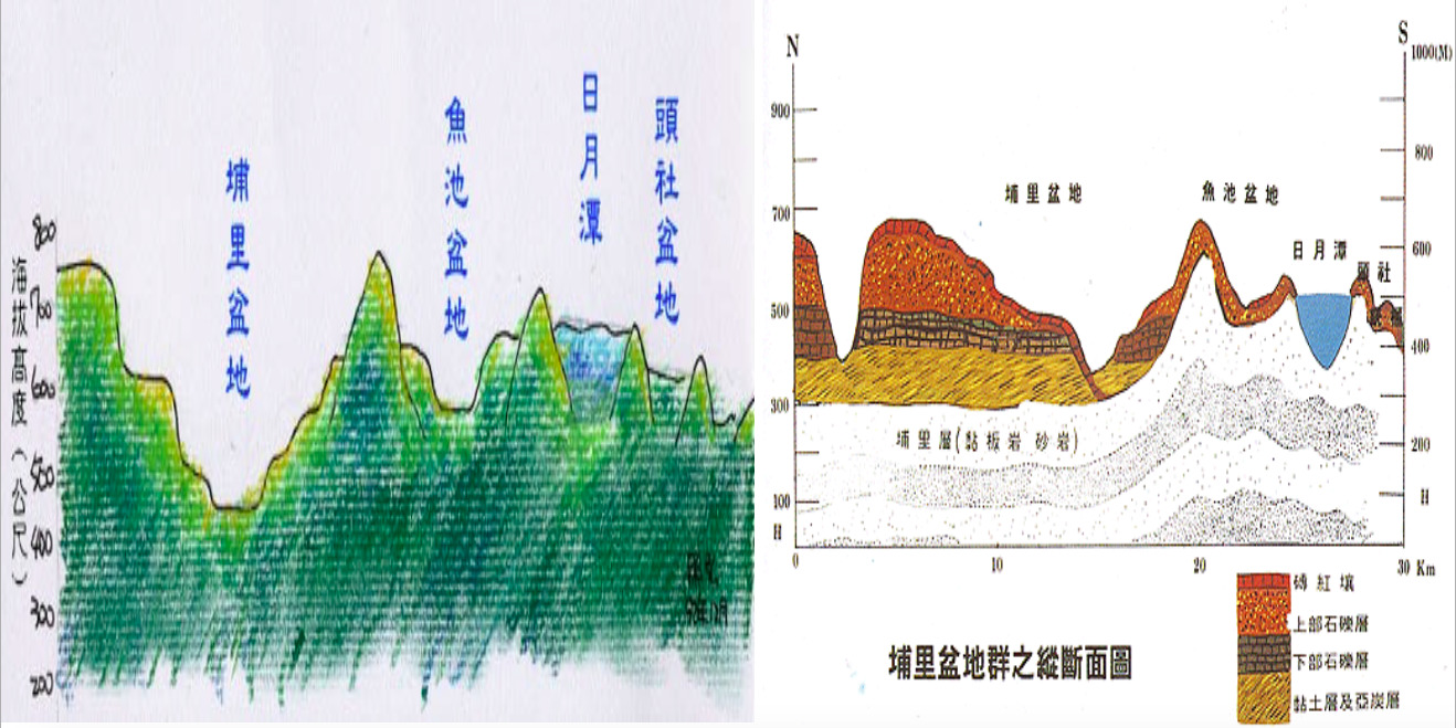
The chart on the left shows a 2D diagram of what the land looks like from Puli Basin (埔里盆地) to Toushe Basin (頭社盆地), with Yuchu Basin (魚池盆地) and Sun Moon Lake (日月潭) between these two basins.
The chart on the right shows the geological makeup, or which rocks are present, in and around Sun Moon Lake. In that chart above, the:
|
Red Layer
|
is laterite soil.
|
|
Orange Layer
|
is upper gravel
|
| |
|
Brown Layer
|
is lower gravel.
|
|
Yellow Layer
|
is clay.
|
with the
|
White/Silver Layer
|
a mixture of slate and sandstone.
|
Laterite soil is unique in that it forms through a process known as laterization, which is when high temperatures and heavy rainfall make things like silica and alkaline in the soil disappear and replace it with aluminum and iron oxides. Why is the depletion of one material and the replacing of it with another so important? Because the original material (silica and alkaline) is soluable, meaning these things dissolve in water, thus depriving plants of necessary nutrients to grow since their nutrients "disappear" in water. But through laterization, these soluable materials are washed away or "destroyed" and replaced with insoluable materials like aluminum and iron oxides, which help keep the nutrients "intact" for plants to grow in this "new" kind of soil known as laterite soil .
Gravel in simple terms is basically the "combination" of all rock fragments piling up. They form because of weathering, which is when things like the wind and rain break away or "destroy" the rocks, as well as erosion, which is they are then moved to a new place by these same forces. Places with an abundance of gravel will lack in plant life as plants obviously need more soil to thrive in instead of simply a big pile of rocks.
Clay is a kind of soil that forms when rocks are in constant contact with air, water or steam, and over time will be broken down by weathering, leaving a kind of "harder" soil type material around that holds water. Clay will harden easily in warmer conditions and soften of course in wetter areas, which make plant life a "hit or miss" opportunity in areas with such soil conditions.
Slate and sandstone are similar in appearance but geologically differ. Slate is a metamorphic rock meaning it formed because of weathering or eroding a different rock. And sandstone is a sedimetnary rock meaning the weathered or eroded rock moves to a new location, thus "creating" new rocks from those broken eroded pieces or sediments. Plant life has the potential to thrive in areas with slate and sandstone as their are lots of nutrients for the plants.
日月潭與周遭區域的地質成因
為了瞭解日月潭和周遭區域的地質動力,得先來瞭解日月潭的地質與岩石。現在來看下方兩個圖表
左側2D剖面圖依序為埔里盆地、魚池盆地、日月潭盆地、與頭社盆地,日月潭盆地位在魚池盆地與頭社盆地之間。
右側圖示為埔里盆地群之縱斷面圖,圖示中日月潭區域地層的岩石分佈::
|
紅色地層
|
我紅土層.
|
|
橘色地層
|
為上層碎石層
|
| |
|
棕色地層
|
為下層碎石層
|
|
黃色地層
|
為黏土層
|
以及
紅土層(Laterite soil)受到一種獨特的地質作用影響,這個地質作用稱為紅土化(laterization),是指高溫、高雨量讓土壤中的矽、鹼性物質流失,替換為鋁、氧化鐵等礦物,為什麼礦物替換如此重要?因為原始礦物的水溶性較高,這些溶於水的必要營養物流失後,替換為不溶於水的物質,讓植物無法吸收成長,這個作用會形成一種新的土壤稱為紅土。
碎石層(Gravel)基本上是所有岩石碎屑堆疊在一起的稱呼,岩石受到像是風、雨水的風化作用影響而脆弱破碎,再受到侵蝕作用影響,讓這些碎塊移動到一個新的地方,植物生長需要含水量較多的土壤而不是碎石,所以碎石含量較為豐富的區域不利於植物生長。
黏土層(Clay)是一種土壤類型,當岩石持續接觸空氣、水、河流,會受到風化作用影響碎裂,變成較為堅硬的含水土壤,黏土在溫度較高的時候很容易變得堅硬,而在較潮濕的時候變得鬆軟,這種土壤不利於植物生長而得碰運氣。
板岩與砂岩(Shale and sandstone)兩者外型相似但地質成因不太相同,板岩為變質岩,受到風化與侵蝕作用而成,而砂岩則是沈積岩,岩石風化後受侵蝕,被帶到一個新的位置而成岩,植物較有可能生長在這些區域,因為板岩與砂岩含有較多利於植物生長的營養成分。
|
Logging Requirements:
Sun Moon Lake is more than just the largest natural lake in Taiwan. It is a gem of Geological Wonder as it is the only lake in this area that did not dry up like its neighboring ones. At the Posted Coordinates you will be brought to a unique sight where you can get a glimpse into its rich geological past of Foldings, Faults, and Erosion, and at the same time maybe even see a bit into its future. So while exploring this picturesque piece of paradise, why not join a tour of a different kind — Earth Cache Tour — here at Sun Moon Lake.
登錄任務 日月潭不只是台灣最大的湖泊,還是地質奇景,因為他是這個區域唯一沒有乾涸的湖泊,在地質寶點可以觀察到豐富的地質地景,像是褶曲、斷層、與侵蝕作用,還有可能觀察到他未來的變化,所以一邊探索如畫的天堂一隅時,何不在日月潭也來一場非凡的地質之旅呢?
For the tasks of this Earth Cache, you will "design" your very own geological tour of Sun Moon Lake in a sort of "Build-Your-Own-Earth-Cache Adventure kind of way. What do I mean? Well, let's see how we can get going with our very own "Build-Your-Own-Earth-Cache Adventure!
這個地質寶任務需要你設計屬於你自己的日月潭地質之旅,我的意思是什麼?建置屬於你的地質寶冒險(Build-Your-Own-Earth-Cache Adventure),藉此來看看你可以從這次地質寶冒險中探訪什麼地點與看到什麼!
1. In order to get your adventure started let's first do a little "pre-adventure" task here. In this Earth Cache, we learned about Foldings, Faults, and Erosion. In the description page above (under the section The Geological Makeup of Sun Moon Lake & Its Surrounding Area), you saw this chart:
要展開你的冒險之前,得先來做點事前準備作業。這個地質寶可以學習褶曲、斷層、與侵蝕作用,上方的地質寶頁面中,你可以看到這個圖表。

Task Question: Based on what you have learned about Foldings and Faults, which areas in the diagram above show an anticline and which areas show a syncline? Are there any other types of crustal folds that you can identify in that picture above? How did you come to your conclusions?
任務要求:根據你學習到有關褶曲、斷層的知識,斷面圖中哪個區域是背斜、哪個區域是向斜?你有在斷面圖中看到其他褶曲類型嗎?你是如何得到這些結論的呢?
2. Now to get going on with the Build-Your-Own-Earth-Cache Adventure, at the posted coordinates you will be able to see the actually forces of Mother Nature that shaped this marvel of a lake. Observe the lake and its surroundings. Based on what you have learned about Foldings, Faults, and Erosion. identify one area that you would say is the result of Folding, one area that is the result of Faults, and one area that is the result of Erosion. After identifying these examples of Foldings, Faults, and Erosion, estimate the distance between each of these points. What does the distance between each of these points tell you about how the forces of Mother Nature acted when She shaped this area? In other words, what direction(s) did the forces act in to shape the land in such a way? (Hint: Use your compass to estimate the distance/degree to help in determining the direction the Mother Nature "traveled" in to create these landforms.)
接下來,要建置屬於你的地質寶冒險。在地質寶點,你可以看到大自然如何塑造這個令人驚豔的湖泊,觀察湖泊與周遭環境,根據你所學到跟褶曲、斷層、與侵蝕作用的知識,辨識一下哪個區域可能是褶曲的結果、哪個區域是斷層的結果、哪個區域是侵蝕作用的結果?辨識出來之後,嘗試著估計這幾個區域之間的距離。這些點之間的距離可以讓你瞭解大自然如何塑造地形,換句話說,估計距離可以讓你發現大自然形塑地形的方向。(提示:使用你的羅盤裝置估計距離和角度,藉此來決定大自然創造地景的方向。)
3. Now comes the real fun — Build-Your-Own-Earth-Cache Adventure! Are you ready? Let's do this!
In the map below you will see a "touristy" of Sun Moon Lake. But do not worry about it being too "touristy" because we are turning it into a GeoMap! That's right! It's time to take that tourist persona and turn it into an "Earth Scientist" here. So while enjoying the beautiful sights, you not only get to get your Kodak Moments on at one of the most beautiful places in all Taiwan but also get to put on your very own Geologist Thinking Cap and make observations and come to conclusions about this marvel of Mother Nature.
So, look at the map below and find the four waypoints referenced on this cache and locate those waypoints on the map. At each of these waypoints are areas where you can observe crustal foldings, fractured faults, and water erosion up close and personal. However, you don't have to visit all of them; you just need to visit at least two of these waypoints! So, pick at least two of those places around Sun Moon Lake and before you depart on your adventure, which Earth Science feature — crustal foldings, fractured faults — do you feel will be most noticeable. How did you come to your conclusion?
接下來,更好玩的是設置屬於你的地質寶冒險!你準備好了嗎?來冒險吧! 在下方地圖中,你會看到日月潭腳踏車旅遊圖,別擔心這個行程太觀光,因為我們即將把旅遊地圖轉變為地質地圖,沒錯,現在是從觀光客變為地質學家的時候。在探訪這個台灣美景的時候,你不只會有美照時刻,還要請你認真思考地質,好好來觀察大自然的驚人力量。所以,在地圖上找到四個地點(waypoint),每個地點可以就近觀察到褶曲、斷層、與侵蝕作用。不過,你不需要跑完所有的地點,你至少需要探訪兩個地點,所以,在開始你的地質寶冒險之前好好選擇兩個地點,試著揣想一下這些地點的地質現象,你覺得哪種地質現象看起來比較明顯(褶曲、斷層、或侵蝕)?以及解釋你是如何思考而得到這個答案?

4. Now that you have picked your two places, go get your "Build-Your-Own-Earth-Cache Adventure on and visit these areas. Based on what you have learned about crustal foldings, fractured faults, and water erosion, and based on your initial guesses from the task above, which of these geological processes were most noticeable at the area you chose? Which ones were least noticeable? What do you think could explain your results?
現在選擇兩個地點,開始屬於你的地質寶之旅,根據你學習到跟褶曲、斷層與侵蝕有關的知識,和根據你上一題的猜測,實際探訪地點觀察後,這些地點之中哪種地質現象比較明顯?而哪種地質現象最不明顯?解釋你的觀察。
5. After visiting the two areas and making the observations in both as explained in Task 3. and 4 above, compare your findings of the two areas. Was the geological process that was more noticeable the same or different in these areas? Based on what you have learned about crustal foldings, fractured faults, and water erosion, and based on your observations, how would you explain the similarities and/or differences? (Hint: Were there any "outside" forces that could have caused such similarities or "discrepancies"?) Also, in which direction did the forces of Mother Nature act in to form what you observed?
完成任務3、4之後,請你比較這兩個區域的觀察結果。不同地點中是否有相同、或是不同的地質現象?根據你學習到有關褶曲、斷層、與侵蝕的知識,以及根據你的觀察,你會如何解釋這種相似性、或是相異性?(提示:有沒有任何「外在」力量影響相似或相異性。)還有,你觀察到大自然作用的方向是什麼。
6. After you complete your Build-Your-Own-Earth-Cache Adventure with all those Kodak Moments, please send me a photo via email or Geocaching Messenger with at least one of the geological processes described in this Earth Cache (crustal foldings, fractured faults, and water erosion,) circled in your photo, and something identifying you in that photo as well (i.e. your face, a TB, your GeoName on a piece of paper, etc.)
完成屬於你的地質寶冒險之旅的美照時刻後,請將答案寄到我的信箱或是Geocaching Messenger,照片內容請包含你、你的辨識物、或你的GeoName,還有請標示這張美照中的地質現象。
7. Based on all your observations and what you have learned in this Earth Cache about crustal foldings, fractured faults, and water erosion, what would you say could be one (or more) possibilty/ies to why Sun Moon Lake is the only lake in the area? Why did it not dry up like the other ones in and around the Yuchi Basin here in Nantou?
根據你的觀察、地質寶頁中的知識,你覺得日月潭將來會如何變化發展?你覺得為什麼日月潭不會像魚池盆地一樣乾涸?
8. (Optional) Post of photo of yourself somewhere around Sun Moon Lake!
(選擇性任務) 線上發布你在日月潭任何的地點的照片。
You may log a Found It! on this cache after you have completed the tasks and emailed me the answers. If there are any issues with your answers, I will contact you. And as a friendly reminder, please do not post any of the answers in your logs. Thank you for visiting this Earth Cache. I hope you enjoy your time around Sun Moon Lake!
寄送答案後就可以線上登錄,不過你必須實際拜訪這個地點與完成這些任務,若你的答案有任何疑問,我會再聯繫你。友善提醒,請不要線上公布你的答案。感謝你探訪這個地質寶,希望你享受日月潭的時光。