
La Earthcache / The Earthcache
► Contexte géologique local
Le vaste espace central de l’île de Noirmoutier (1/3 de l'île) est occupé par des marais salants.
Ces marais prennent place sur des formations sédimentaires contemporaines d'un point de vue géologique, c'est à dire appartenant à l'étage actuel du Flandrien (-12 000 ans à aujourd'hui).

Partons à la découverte de ce colmatage flandrien et de ses caractéristiques.
► Le colmatage flandrien de Noirmoutier
A la fin du Pléistocène et de la dernière période glaciaire, le centre de Noirmoutier est formé d'une vaste dépression de calcaire éocène fortement érodée suite à la baisse du niveau de la mer.
La remontée des températures provoque une transgression marine rapide entrecoupée de phases de ralentissement au cours desquels des cordons littoraux dunaires se forment.
La dernière phase de la transgression submerge les marécages en arrière des cordons dunaires occupant la dépression centrale, les transformant en milieu intertidal (estran).
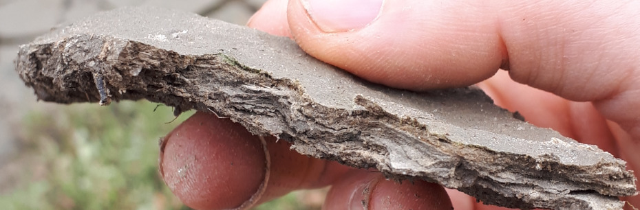
Cette zone entre deux eaux est alors progressivement comblée par des alluvions fluvio-marins appelés « bri marin » ou « argiles à scrobiculaires ».

Le "bri ", de couleur brun, est constitué par de très fines particules de quartz, feldspath et calcite, accompagnées de minéraux argileux.
Son origine est fluvio-marine :
- marin avec la présence de coquilles de Scrobicularia plana et Cardium edule (Coque commune).
- fluvial car les eaux turbides sont alimentées en sédiments fins par les apports de la Loire. Ces masses en suspension sont refoulées dans la baie de Bourgneuf où elles s'accumulent.
► Texture d'un sol : définition et détermination
La texture d'un sol est la catégorisation des sédiments le composant selon leur taille (granulométrie).
Elle s'exprime en proportion de chaque taille d’éléments minéraux :
- les graviers (> 2 mm)
- les sables (20 µm-0,2 mm)
- les limons (2 µm-20 µm)
- l'argile granulométrique (< 2 µm)

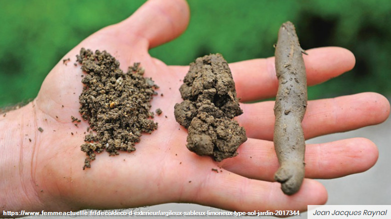
Au delà d'un contrôle visuel, il existe des tests empiriques permettant de déterminer les proportions en classes granulométriques :
- Test du toucher : plus la terre est collante et les mains difficiles à laver, plus la terre est argileuse. Si on ressent beaucoup de « grains » sous les doigts et qu’elle colle peu, alors la terre est peu argileuse.
– Test de la boule : On forme une boule de 3 à 4 cm de diamètre dans la paume de la main terre puis on la laisse tomber d’environ 1 mètre hauteur. Si la boule reste homogène, elle est riche en argile, si on observe des fissures sur les côtés, elle est pauvre en argile, si elle éclate en touchant le sol, alors il y a quasiment pas d’argile.
– Test du boudin : On fait rouler la boule entre les mains jusqu’à obtenir peu à peu un cordon et on surveille à quel diamètre ce cordon va casser. Les observations dépendent de la cohésion de la terre, déterminée par sa teneur en argile, plus le cordon est fin (< 5mm de diamètre), plus il y a d’argile.
► Sol et sécheresse
La sensibilité d'un sol à la sécheresse est fortement liée à sa texture. Plus les sédiments sont fins, plus la sensibilité du sol au retrait de l'eau par évaporation est importante.
Les sols sableux sont très peu sensibles à la sécheresse, ne provoquant aucun mouvement de ce sol ; à contrario, les sols argileux sont les plus sensibles à la diminution de leur teneur en eau.
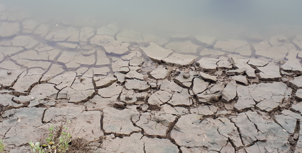
Dans le cas les plus extrêmes, il se produit en cas de sécheresse la mise en place de fentes de dessiccation, appelée aussi fentes de retrait ou mudcrack.
C'est une structure sédimentaires formée lorsqu'un sédiment argileux se dessèche et se contracte du fait de la réduction de sa teneur en eau.
Cette fissure habituellement béante forme un réseau polygonal interconnecté d'où son nom (polygone de dessiccation) et peut atteindre plusieurs centimètres de large.
► Local geological context
The vast central area of Noirmoutier Island (1/3 of the island) is occupied by salt marshes.
These marshes take place on contemporary sedimentary formations from a geological point of view, ie belonging to the current Flandrian stage (-12,000 years ago to today).
Let's go and discover this Flandrian clogging and its characteristics.
► The Flandrian sealing of Noirmoutier
At the end of the Pleistocene and the last ice age, the center of Noirmoutier is formed by a vast depression of Eocene limestone strongly eroded following the drop in sea level.
The rise in temperatures causes a rapid marine transgression interspersed with phases of slowing down during which dune shorelines are formed.
The last phase of the transgression submerges the swamps behind the dune ridges occupying the central depression, transforming them into an intertidal environment (foreshore).
This zone between two waters is then progressively filled by fluvio-marine alluvium called “marine bri” or “scrobicular clays”.
The "bri", brown in color, is made up of very fine particles of quartz, feldspar and calcite, accompanied by clay minerals.
Its origin is fluvio-marine:
- marine with the presence of Scrobicularia plana and Cardium edule (Common shell) shells.
- fluvial because the turbid waters are supplied with fine sediments by the inputs of the Loire. These suspended masses are pushed back into the bay of Bourgneuf where they accumulate.
► Soil texture: definition and determination
The texture of a soil is the categorization of the sediments composing it according to their size (grain size).
It is expressed in proportion to each size of mineral elements:
- gravel (> 2 mm)
- sands (20 µm-0.2 mm)
- silts (2 µm-20 µm)
- granulometric clay (<2 µm)
Beyond a visual check, there are empirical tests to determine the proportions in grain size classes:
- Touch test: the more the earth is sticky and the hands difficult to wash, the more clayey the earth. If you feel a lot of "grains" under your fingers and it sticks out little, then the soil is not very clayey.
- Ball test: Form a ball 3 to 4 cm in diameter in the palm of the earth, then drop it about 1 meter high. If the ball remains homogeneous, it is rich in clay, if there are cracks on the sides, it is poor in clay, if it bursts when touching the ground, then there is almost no clay.
- Test of the sausage: We roll the ball between the hands until gradually obtaining a bead and we monitor at what diameter this bead will break. Observations depend on the cohesion of the earth, determined by its clay content, the thinner the bead (<5mm in diameter), the more clay there is.
► Soil and drought
The sensitivity of a soil to drought is strongly linked to its texture. The finer the sediment, the greater the sensitivity of the soil to water removal by evaporation.
Sandy soils are not very sensitive to drought, causing no movement of this soil; conversely, clay soils are the most sensitive to a decrease in their water content.
In the most extreme cases, it occurs in the event of drought the establishment of desiccation slots, also called withdrawal slots or mudcrack.
It is a sedimentary structure formed when a clay sediment dries up and contracts due to the reduction in its water content.
This usually gaping crack forms an interconnected polygonal network, hence its name (desiccation polygon) and can reach several centimeters wide.
► Sources bibliographiques / Bibliographical sources
Les Questions / The Questions
La lecture attentive du descriptif de la cache, ainsi qu'une observation des éléments de terrain et un peu de déduction sont normalement suffisants pour répondre aux questions de cette EarthCache.
A careful reading of the description of the cache, as well as observation of terrain features and some deduction is usually sufficient to answer questions of this EarthCache.
Questions pour valider :"Colmatage Flandrien à Noirmoutier"
Questions to validate: "Flandrien sealing in Noirmoutier"
Point 1 : N 46° 59.861 W 002° 16.224
- Question 0 : Prenez une photo de vous ou d'un élément vous identifiant avec les marais salants en arrière plan.
Cette photo devra au choix nous être transmise avec les réponses ou être ajoutée à votre log.
- Question 0 : Take a photo of yourself or something that identifies you with the salt marshes in the background.
This photo will have to be sent to us with the answers or to be added to your log.
Après le TrealHead, vous longez un ancien œillet salant sur votre gauche (direction nord). Au WP1, Approchez vous du bord de cet œillet (direction ouest) et observez le sol de son rebord.
After the TrealHead, you walk along an old salt eyelet on your left (northbound). At WP1, approach the edge of this eyelet (west direction) and observe the ground from its edge.
- Question 1 : Décrivez ce sol. De quelle formation s'agit-il ? Vous voyez des éléments blancs au fond. De quoi s'agit-il ? Déduisez-en l'origine de cette formation.
- Question 1 : Describe this soil. What training is it? You see white elements at the bottom. What is it about ? Deduce the origin of this training.
- Question 2 : Prenez entre vos doigts un peu de sol. Réalisez le test du toucher et au moins un des deux tests de la boule ou du boudin. Déduisez en la texture de cette formation.
- Question 2 : Take a little soil between your fingers. Perform the feel test and at least one of the two ball or sausage tests. Deduce the texture of this formation.
Point 2 : N 46° 59.910 W 002° 16.306
- Question 3 : Vous voici au début d'un étier. Regardez le fond de celui-ci dans la direction nord sur ces premiers mètres. Décrivez la structure du sol. Comment s'appelle ce phénomène ? Cela conforte t-il vos réponses précédentes ?
- Question 3 : Here you are at the start of a stage. Look at the bottom of it looking north for those first few meters. Describe the structure of the soil. What is this phenomenon called? Does this support your previous answers?
Vous pouvez vous loguer sans attendre notre confirmation,
mais vous devez nous envoyer les réponses en même temps soit par mail via notre profil (
fafahakkai), soit via la messagerie geocaching.com (Message Center).
S'il y a des problèmes avec vos réponses nous vous en ferons part.
Les logs enregistrés sans réponses seront supprimés.
You can log this cache without waiting for our confirmation, but you must send us the answers at the same time, by e-mail via our profile (fafahakkai) or by the system of Message Center of geocaching.com.
If there is a problem with your answers we will notify you. The logs recorded without answers will be deleted.
Rappel concernant les « Earthcaches »: Il n'y a pas de conteneur à rechercher ni de logbook à renseigner. Il suffit de se rendre sur les lieux, de répondre aux questions ci-dessus et de nous renvoyer les réponses.
Reminder concerning "Earthcaches": there is neither a container to look for nor a logbook to sign. One need only go to the location, answer to the differents questions and send us the answers.