Question 問題
Distinguish the erosional landforms of these spots. 辨識這些地點的海蝕地景

a. Stump b. Stack c. Arch d. Cave e. Crack f. Wave-cut platform
a. 海蝕樁 b. 海蝕柱 c. 海蝕拱門 d. 海蝕洞 e. 海蝕隙、裂縫 f. 海蝕平台
1. What is spot A? 景點A是什麼?
2. Explain why spot A is in the Shimen Arch. 試著解釋為什麼景點A會在石門裡?
3. What is spot C and D? 景點C和D分別是什麼?
4. Which spot (A B C D) will propably increase (rather than be eroded or weathering)? 哪個景點(A B C D)有可能增長(而不是受侵蝕或風化)?
5. Predict whether the Shimen Arch will be collapsing or not? Explain your answer. 試著預測石門會不會崩塌?解釋你的答案。
6. Photo the Shimen Arch (spot B) containing Andesite with you, your identifying item, or your GPS device. 在景點B,請你、你的辨識物、你的GPS裝置跟含有安山岩的石門地層露頭拍照。
Log this cache "Found it" and send me your suggested answers either via my profile, or via geocaching.com (Message Center) messaging, and I will contact you if there is a problem. Do not post your answers in the log except logging task 6. Thank you. Favorite Point Appreciated. 線上登錄這個地質寶,請將答案寄到Geocaching.com的信箱,若有什麼問題,會再回覆你。除了登錄任務6,請不要把你的答案公佈在線上log中,歡迎給予FP,感謝。

Gate to Ocean #ShimenArch
獨特的石門洞
石門洞位在北部濱海公路的海岸,石門洞中文名稱相當混淆,實際上石門並不是海蝕洞而是海蝕拱門。石門洞特別的地方在於它是遠離海洋的海蝕拱門,通常海蝕拱門會在海洋中或是潮間帶,但是石門洞非常不同,整個海蝕拱門高於海平面整整兩公尺。

石門洞的主要組成
一百萬年前大屯火山群噴發,堆積了厚厚一層火山熔岩與火山灰,安山岩是大屯火山群主要產出的岩石類型,沙子、安山岩、火山灰沈積形成地層,成為濱海的小丘。海洋侵蝕該地層後形成海蝕洞與海蝕拱門,地質活動擠壓讓地殼上升,最終讓海蝕拱門高於海平面。 地層露頭的表面並不光滑。安山岩硬度比砂岩高,導致砂岩更容易受侵蝕作用影響,讓安山岩碎塊暴露出來,這些安山岩讓地層的垂直表面異常凹凸不平。此外,高含量的鐵元素與風化作用讓安山岩帶有更多紅色,跟黃色的砂岩有所區別。
海蝕地景:海蝕洞、海蝕拱門、海蝕柱、與海蝕樁
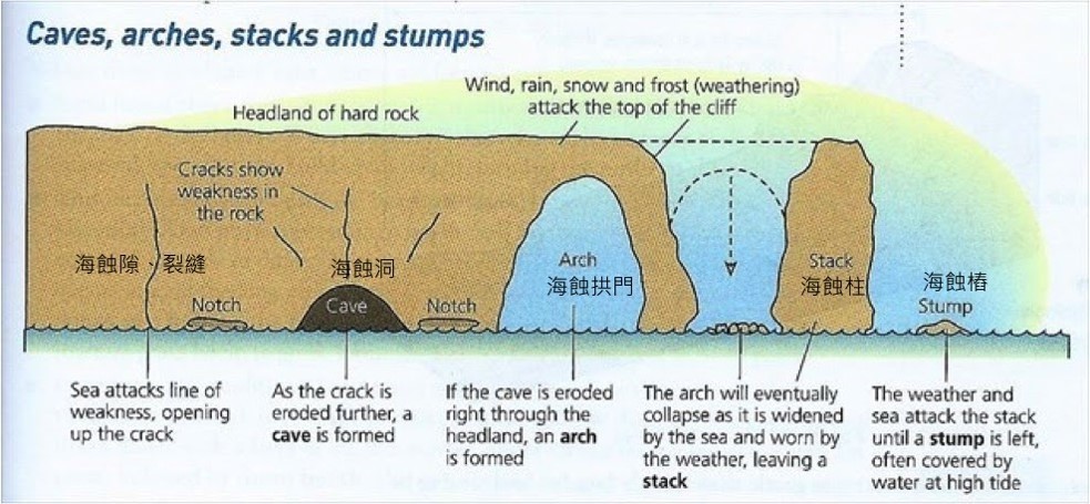
海蝕作用影響海岸的岩石,侵蝕作用會先作用於岬角岩石的脆弱線,造成裂縫或形成海蝕隙。 接下來,海蝕持續作用下會形成海蝕洞。當海蝕洞越來越大,穿過了岬角岩石另一側便會形成海蝕拱門。海蝕拱門上方岩石也會受到雨水、風、與其他影響因子的風化作用影響,讓該處岩石變得脆弱,當海蝕拱門上方連結的岩石落下時,海蝕柱就成形了。接近海平面部位的海蝕柱仍持續受到海蝕作用影響,最後會形成海蝕樁。 海蝕平台則常見於潮間帶區域。
附帶一提,此處海蝕平台可觀察到獨特的藻礁。藻礁跟珊瑚礁相似,他們都會將海水中游離的鈣離子固化在細胞壁或是生物骨骼中,這個過程可以產生像岩石一樣硬的礁石。在石門洞區域可觀察到多樣地景,海岸獨特的地景可清楚辨識出侵蝕與風化作用的影響,藻礁則讓地景更為獨特。
歡迎拜訪這個地質寶與回答簡單問題來拓展海洋地景的知識。
Gate to Ocean #ShimenArch
Uniqueness of Shimen Arch
Shimen Arch is located at the coast along the Northern Coastal Highway. The Mandarin name is called “shih-men-tung”.“Shih-men” means stone gate and “tung” refers to a cave. Whole meaning of Madarin name is quite confusing. Shimen is actually an erosional landform as an arch rather than a cave. The uniqueness of Shimen Arch is an arch caused by the ocean but away from the ocean. The marine erosional landform of arch is usually in the ocean or in the tidal area. But Shimen Arch is so different that the whole arch is two-meters above the tidal peak line.

Main composition of Shimen Arch
A million year ago, a volcano of Datun Mountain Range erupted and deposited a thick layer of lava and ash. Andesite is the main rock type produced by the volcano of Datun Mountain. Sands, andesites, and lava ashes deposited forming strata in a small hill near the ocean. Ocean eroded the strata into caves and an arch. Tectonic uplifting caused the arch above the sea level. The surface of exposed strata is not smooth. The hardness of andesite is higher than sandstone. Sandstone was more easily eroded away and then andesite and its debris exposed. Those andesites made the surface of the strata extremely uneven vertically. Besides, the high level of iron and weathering made the andesite with more color of red which is different from the yellow color of sandstone.
Coastal landforms: caves, arches, stacks, and stumps

Coastal erosion influences rocks located at the seashore. The erosion would affect the weak line on the headland of hard rock inducing cracks first. Then erosional cave would be formed by enduring ocean erosion. The arch would be formed while the cave became bigger till the other side of the rock of headland. The rock on the arch was affected by weathering and erosion from rain, wind and other influencing factors. When the connecting rock was fallen, the stack was formed. The stack would be carved by stable ocean erosion at the part near the sea level. The stump was finally formed. At the tidal region, a wave-cut platform is also common.
By the way, unique algal reefs can be observed at the wave-cut platform at the area of Shimen Arch. Algal reefs is similar to coral reef. They can consolidate calcium in cell wall or skeleton. Hence, the process may produce reefs as hard as rocks.
At the Shimen Arch area, diverse landforms can be obsevered. The result of erosion and weathering processes can be clearly distinguished with special landforms at the seashore. Algal reefs make the landform more uinque.
Visit the earthcache and answer some easy question to expand knowledges about coastal landforms.
感謝石門區公所,請玩家留意安全。
大眾運輸工具 Public Transportation
台灣好行
捷運淡水站2號出口右轉,直走約100公尺公車站第5候車區-台灣好行 716 皇冠北海岸線站牌,請依地面候車線排隊上車。
基隆汽車客運 862、863