Welcome to Snow Mountain!
In this Earth Cache, you will learn about Glacier Erosion, specifically four landforms that glaciers have helped create — glacier cirques, hanging glaciers, glacial cols, and glacial lakes — here near and around Snow Mountain. Upon learning all there is to know about glaciers and their force of sculpting when it comes to creating glacier cirques, hanging glaciers, glacial cols, and glacial lakes, you will be ready to put on your Earth Science Thinking Caps and get geological here at the place where the largest traces of glacier erosion can be found in all Taiwan! And after you answer the task questions and complete all your Glaciological Studies and Observations (which can all be found at the bottom of this page), you can log a “Found It!” for this Earth Cache. I hope you enjoy! Let’s get going and see what this Glacier Wonderland of Fun is all about . . .
|
How Glaciers Form and How They Reshape the Land:
To understand exactly what a glacier is and how they reshape the land, let us look at the two charts below:
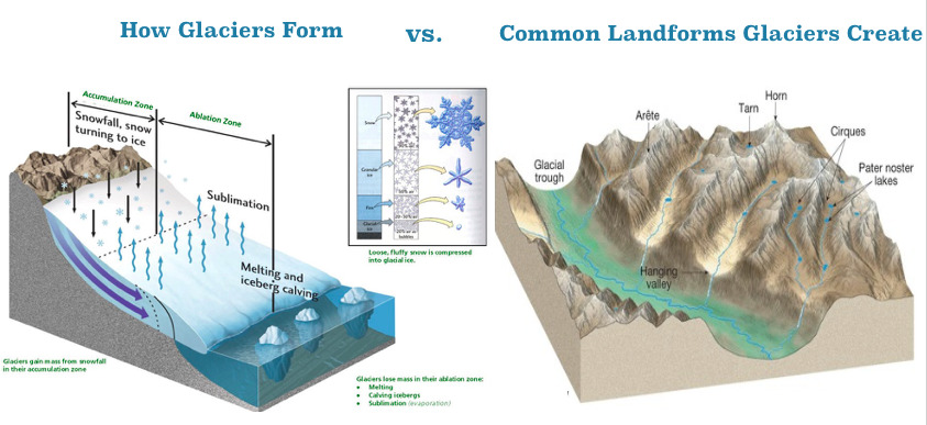
So the magic that is Mother Nature is quite amazing isn't it? And after all this magic is played out over the course of many, many millennia, we get some of the most beautifully sculpted landforms. A few of the "star players" of the glacier eroded landscape can be viewed in the diagram below:
And a brief explanation of some of these "star players" —
Pyramidal peak — a "Matterhorn-like" landform that is shaped like a tetrahedron
Arête — the area between two sides of the "Matterhorn"
Tarn or corrie lake — a glacier lake
Corrie, cwm, or cirque — a bowl-like depression in the side of a mountain
|
Now that we have gone over what glaciers are and a few of the more "famous" landforms they create, let us now dive into four main glaicer landforms that can be observed here at Snow Mountain — glacier cirques, hanging glaciers, glacial cols, and glacial lakes — and learn about how glaciers helped in scultping these wonders of Mother Nature.
|
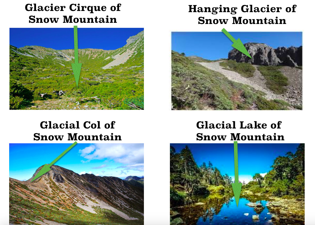
The Big Four of Snow Mountain — Glacier Cirques, Hanging Glaciers, Glacial Cols, and Glacial Lakes
Glacial cirques (also known by many other names as you can see from the diagram in the section "How Glaciers Form and How They Reshape the Land" above) are simply a depression in the land right near the top of the mountain. These cirques look like a bowl on its side. As the glacier flows down the mountain and over to another hill, it picks up momentum and "swings" back up the slope like a pendulum. This action is repeated over and over again for many, many years, thus slowly eroding the land. The weight of the water underneath "sinks" into the side of the mountain thus forming that depression in the land and creating a cirque.
After the glacier does its work we are left with that unique glacier landform here, which is usually surrounded on three sides by steep cliffs. The highest cliff is called the headwall. The fourth side, which is the "non-steep side", forms the lip, threshold or sill. This area is where the glacier flowed away from the cirque. You can observe the largest glacial cirque in all Taiwan here at Waypoint 01.
Hanging glaicers as the name implies are glaciers that rest above another glacier, thus giving the appearance that they are just "hanging" there. Through the magic that is Mother Nature, a glacier won't necessarily stay "intact". I mean as it moves down the mountain, the water might be "diverted" to other locations or "get lost" along the way because of rugged terrain, rocks and plant life in its path, or any obstacle that will change its direction. So because of this "interruption" in the glacier flow, its water is "moved" to different locations or maybe even "stopped". And sometimes this water is "abandoned" while the other "non-interrupted" water continues to flow downward. This "lonely" or "forgotten" water still acts with its "magical" force and erodes the land just like the glacier before it, and even though it did not "complete the "race" down to the valley below, it still "hangs out" there above its older brother, thus leaving the landform known as a hanging glacier. You can observe a hanging glacier at Waypoint 01 as you look towards Snow Mountain North Peak.
Glacial col is simply the lowest point between two peaks and is located between two cirques. They form because of glaiers on either side eroding the arête or narrow piece of ridgeline, thus leaving a "smoother-looking" U-shaped area of land between two mountain peaks, which here are between Snow Mountain Main Peak (雪山主峰) and Beilingjiao (北稜角). You can observe the glacial col from the Posted Coordinates.
Glacier lakes (also known my many other names as you can see from the diagram in the section "How Glaciers Form and How They Reshape the Land" above) are formed at the foot of a glacier. As glaciers move and flow, they erode the soil and sediment around them, leaving depressions and grooves on the land. Meltwater from the glacier fills up the hole, thus making a lake. You can observe a glacier lake here at Waypoint 2.
|
Mother Nature is one amazing force, isn't She? It is amazing how something as "simple" as "ice and water" can do so much to the land. Granted it takes thousands upon thousands of years to sculpt the one-of-a-kind landforms but still, I'd say it is all pretty impressive wouldn't you agree?
Now that we have learned how the "Big 4 Glacial Landforms of Snow Mountain" are formed, let us conclude with the "main event" here and see exactly what these landforms look like here at Snow Mountain
|
Snow Mountain — The Largest Collection of Glacier Traces in Taiwan
Snow Mountain has a list of great feats — from being the second tallest mountain in all Taiwan to being the highest mountain of the Snow Mountain Mountain Range (雪山山脈) to being the last stop (or first stop depending on where you start the trek) of the Holy Ridge of Taiwan. And not to take away from those amazing things but there is one more "accomplishment" that sometimes gets overlooked here — Snow Mountain is home to the largest traces of glacier landscapes in all Taiwan! That's right! The high mountains of Taiwan have been "blessed" with a real-life 🎵Let it Go🎵 show here straight from ❄️ Elsa ❄️ herself. You may find the best preserved glacier landforms across the way in and around The Great Nanhu Mountain of the Central Mountain Range or even further south you can witness traces of Quarternary glaciation upon the only peak along the Tropic of Cancer — Jade Moutain, but it is here at Snow Mountain where you will find the largest traces of glacier landforms, particularly glacier cirques, hanging glaciers, glacial cols, and glacial lakes. Below you can see these four "famous" glacier landforms of Snow Mountain:
|
Logging Requirements:
Snow Mountain may just be "second place" when it comes to its height but it trumps in so many other areas. I mean the mountain was so aptly named "Snow Mountain" because of the constant snow that can seen on and around its peak, and even though She got her name many, many years ago from a simple observation of snow, what if there was more to its name than what met the eye? I mean what if our ancestors saw an unexplainable sight at that time but only knew of "snow" so simply named the mountain as such? But in actuality, it was a precursor to its true name — Snow "Glacier" Mountain. So, Snow Mountain is indeed a Glacier Wonderland of fun and excitement, and definitely a geological treasure of the largest traces of glacial erosion in all Taiwan. So let us journey deep and high into the Snow Mountain Range (雪山山脈) and visit the highest peak of that range and see for ourselves the wonders of glacial erosion here at Snow Mountain!
In order to log a Found It! for this Earth Cache, please go to the Posted Coordinates and the two additional Virtual Stages (Waypoint 01 & Waypoint 02) to complete the following tasks:
1. On your way to Snow Mountain, you will first come to Waypoint 01 where you will see the largest cirque in all Taiwan, which comes in at 1400 meters long and 600 meters wide! While you observe the glacier cirque here at Waypoint 01, take out your GPS device/smartphone and open the compass feature. According to your compass readings, and based on what you have learned about glaciers and their direction of flow down the mountain, in which direction(s)/degree(s) would you say the glacier first flowed down the mountain here to form this cirque, and where did the glacier start to retreat or end? Based on your compass readings, what does this tell you about the glacier as a whole? What could have been the "size" (small, medium, large) of the glacier(s) here at Waypoint 01? How did you come to your conclusions?
2. The "most famous" hanging glacier can be observed near Snow Mountain North Peak (Waypoint 04), however, getting there from Waypoint 01 will require a little bit more time and walking than you may be up for. But don't worry because if you look carefully around the cirque itself here at Waypoint 01, you will also see a landform resembling what appears to be a smaller scale hanging glacial. Based on what you have learned about hanging glaciers as well as glaciers themselves, what does this landform tell you about the dynamics or movements of the glacier? Using your compass, estimate the direction in which the glacier flowed down that area. Also, estimate the height of the hanging glacier and identify the point at which the flow was "interrupted". Please send me a photo via email or Geocaching Messenger with that "interruption point" circled in your photo and something identifying you in that photo as well (i.e. your face, a TB, your GeoName on a piece of paper, etc.) How did you come to your all your conclusions about the hanging glacier here at Waypoint 01?
3. At the Posted Coordinates, which is the peak of Snow Mountain, you will be above the glacial cirque that you observed there at Waypoint 01. You will also be able to observe the glacial col as well, which is onwards towards Beilingjiao (北稜角) (referenced on this cache listing as Waypoint 03). While at the Posted Coordinates estimate the distance from the peak to the glacial col. Also, using your compass, estimate the direction/degree of where the glacial col is located in reference to the peak. Based on what you have learned about glacial cols, and taking into account the fact that cols are formed when the arête is eroded on either side of the ridge, what do the observations and measurements you did tell you about the behavior of the glacier? (Hint: Which side of the col is steeper? The left side or the right side? What does this difference in grade (angle) tell you about how the glacier acted when eroding this area to produce or carve the col?) How did you come to all your conclusions?
4. At Waypoint 02 you will be at the highest lake in all Taiwan — Cui Chi (翠池) — which isn't just any old lake but a glacier lake! As you travel there from the Posted Coordinates, pay attention to the descent down — like the direction in which you are traveling down and the "steepness" of the descent. Based on what you have learned about glaciers themselves and how they travel, and based on what you have learned about glacial lakes, what does the descent tell you about the way the glacier traveled? Would you say it traveled quickly or slowly down to Cui Chi? (Hint: How steep was the descent down? What would that angle of descent tell you about how the glacier eroded the land?) How did you come to all these conclusions?
5. Also at Waypoint 02 there at Cui Chi, use your compass to estimate the direction/degree of the lake in reference to the sloped area you walked down to arrive at the lake. Based on what you have learned about glacier flow, what do your compass readings tell you about the "strength" of the glacier? In other words, why did a lake "suddenly" appear at this location?
6. One last task at Waypoint 2 — take a look around the lake and observe any "peculiarities" or rather "watermarks" of areas that are moist or saturated looking but there is no water over those areas. Also, estimate the current size of the lake and its depth if possible. Based on these observations of "peculiarities" and also based on what you have learned about how glaciers erode the land to make a depression to fill water in, what does the current size of the glacier tell you about the original size of the glacier lake? Does the lake appear to be bigger or smaller than it originally did when it was first formed? Or is it the same size? What do your observations tell you about the glacier itself (its size, its "strength"), and what other factors may have contributed to a change in size? (Hint: Does the water look "pure" or can you observe a lot of rocks and minerals deposited in the lake?) And based on all these observations about the glacier lake and based on your compass reading(s) in Task 5 above, where do you believe the glacier most likely "disappeared" to? How did you come to all these conclusions?
7. Based on all your observations and based on all the on-site measurement tasks, as well as your knowledge of the "Big Four" of Snow Mountain — glacier cirques, hanging glaciers, glacial cols, and glacial lakes — in what order do you feel they formed in? How were you able to come to your conclusion?
8. Optional— Post a photo of yourself or a "Geocaching" item identifying yourself near a landform or other place where there is evidence of glacial erosion here at Snow Mountain.
You may log a Found It! on this cache after you have completed the tasks and emailed me the answers. If there are any issues with your answers, I will contact you. And as a friendly reminder, please do not post any of the answers in your logs. Thank you for visiting this Earth Cache. I hope you enjoy your time on Snow Mountain!