Attention, la cache est accessible à marée basse. Horaires des marées sont ici.
Vous vous engagez de votre propre initiative dans la recherche de cette cache à vos risques et périls. Je décline donc toute responsabilité en cas de problème.
Il s'agit d'une Earthcache, il n'y a pas de récipient à chercher.
Double flèche littorale au Loc’h
La spécificité de cette flèche est sa structure double. Au Loc’h on peut observer deux cordons de galets édifiés par la mer.
Le site du Loc’h présente une formation sédimentaire meuble constituée de deux flèches littorales parallèles protégeant une zone humide et générées par une dérive littorale vers l’est.
La flèche interne s’étend sur près de 200 mètres. Entièrement végétalisée par des plantes halophiles, elle n’est plus active aujourd’hui. Sa mise en place est relativement récente au regard de l’histoire de la rade puisqu’un niveau de schorre fossile, sur lequel elle s’étale, date d’environ 1 000 ans après J.-C. suggérant que les premières étapes de sa construction sont antérieures (entre l’ennoiement de la rade et 1 000 ans avant aujourd’hui). Bien identifiée sur la photo aérienne de 2014 par le cours d’eau et les chenaux de marées qui la séparent de la flèche externe côté mer, elle est depuis peu, progressivement recouverte par cette dernière.
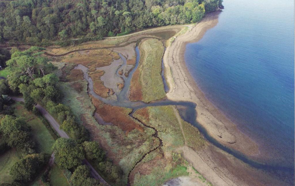
La flèche externe, plus récente (datée du début du 19 siècle aux années 1960), s’enracine sur la côte ouest et s’étend vers l’est, doublant la flèche interne sur presque toute sa longueur. Son alimentation par la dérive littorale a cessé tandis que les courants de tempêtes la repoussent épisodiquement vers les terres resserrant de plus en plus le chenal entre les deux flèches. En 2004, les courants de marées et de vidange du Loc’h ont ouvert une brèche au milieu de la flèche interne, modifiant les conditions écologiques de la zone humide et favorisant le développement de la spartine.
Ces deux cordons (ou flèches littorales) se sont constitués par accumulation de graviers et cailloux apportés par la mer. Ces sédiments grossiers proviennent de l’érosion des falaises situées plus à l’ouest et formées de schistes tendres qui se débitent en lamelles ou de coulées de blocs et d’argile qui ont flué en bas de versant lors de la dernière glaciation.
Ce paysage de flèches littorales est instable, à la merci des tempêtes de vives eaux, modifiant l’organisation des deux flèches ainsi que l’écoulement des eaux du Loc’h. C’est un bel exemple de la plasticité morphologique et écologique de cette zone particulière à l’interface Terre-Mer dont la mise en réserve permet d’étudier son évolution en contexte naturel par des suivis scientifiques.
Coulées boueuses avec gravats
Cette formation est d’origine gravitaire. Dans la gangue argileuse on trouve les gravats de caractère anguleux. La gélifluxion reprend les débris, issus de la gélifraction, ainsi que les éléments sableux et terreux et lors des cycles gel-dégel, les déplace en profitant de la déclivité locale.
On distingue deux sortes de conglomérats selon leur origine.
Formation fluviale : les sédiments sont issus du transport fluvial, arrondis (usés par le transport), d’une granulométrie comparable (qui dépend de la force du courant), classés par taille.
Formation gravitaire : les sédiments sont issus de la gélifraction (cassés par les répétitions de gel et dégel), de caractère anguleux (non usés par le transport), hétérométriques (de différentes tailles), non classés par taille.
Sources
Vidal, Muriel ; Géo tourisme en Presqu’île de Crozon
Wikipédia
Questions pour valider cette Earthcache :
Aux coordonnées de la Earthcache
- Regardez le milieu de la flèche externe. Quelle tendance au niveau de sa forme pouvez-vous constater ?
Au WayPoint 2
- Vous vous trouvez sur la flèche externe. Y-a-t-il de la végétation à vos pieds ? Cette flèche est-elle active ?
Au WayPoint 3
- Vous vous trouvez devant une gangue argileuse avec des sédiments. Ces sédiments sont-ils d’origine fluviale ou gravitaire ? Justifiez votre réponse.
- Quel est le rapport entre cette gangue argileuse et la double flèche littorale ?
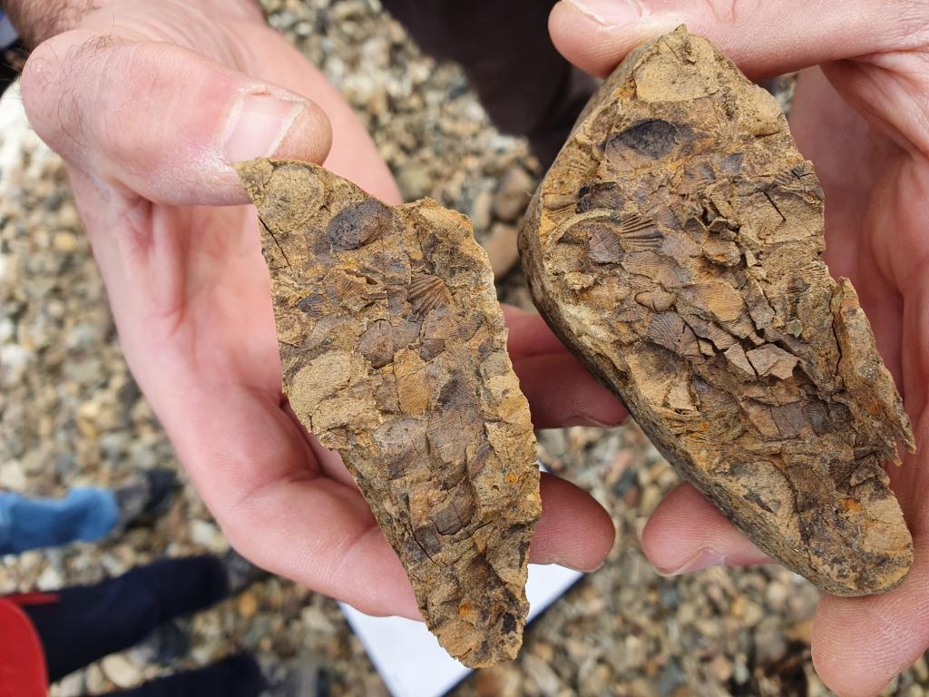
- Une photo de vous ou d’un objet vous représentant sur le site. Si vous trouvez des fossiles sur le sillon, il est strictement interdit de les ramasser, par contre n’hésitez pas à les prendre en photo et joindre à votre log.
Loguez cette cache "Found it" et envoyez-moi vos propositions de réponses soit via mon profil, soit via la messagerie geocaching.com (Message Center), et je vous contacterai en cas de problème. Les logs enregistrés sans réponses seront supprimés.
English version
Please note that the cache is accessible at low tide. Tide times are here.
You engage in the search for this cache on your own initiative at your own risk. I therefore decline all responsibility in the event of a problem.
This is an Earthcache, there is no container to look for.
Double coastal arrow at Loc’h
The specificity of this arrow is its double structure. At Loc'h you can see two cords of pebbles built by the sea.
The Loc’h site presents a loose sedimentary formation made up of two parallel coastal arrows protecting a wetland and generated by a coastal drift towards the east.
The internal spire extends for nearly 200 meters. Entirely vegetated by halophilic plants, it is no longer active today. Its establishment is relatively recent in view of the history of the harbor since a level of fossil schorre, on which it is spread, dates from around 1000 years after J. - C. suggesting that the first stages of its construction is earlier (between the flooding of the harbor and 1000 years before today). Well identified in the 2014 aerial photo by the watercourse and tidal channels which separate it from the outer spit on the sea side, it has recently been gradually covered by the latter.
The newer outer spire (dating from the early 19th century to the 1960s) takes root on the west coast and extends eastward, doubling the inner spire for most of its length. Its supply by the littoral drift has ceased while the storm currents occasionally push it back towards the land, narrowing more and more the channel between the two arrows. In 2004, the tidal and draining currents of the Loc’h opened a breach in the middle of the internal arrow, modifying the ecological conditions of the wetland and favoring the development of cordgrass.
These two rims (or littoral arrows) were formed by accumulation of gravel and pebbles brought by the sea. These coarse sediments come from the erosion of the cliffs located more to the west and formed of soft schists which are cut in slices or flows of boulders and clay which flowed down the slope during the last ice age.
This landscape of coastal spiers is unstable, at the mercy of spring storms, modifying the organization of the two spiers as well as the flow of the waters of the Loc'h. This is a fine example of the morphological and ecological plasticity of this particular area at the Earth-Sea interface, the setting aside of which makes it possible to study its evolution in a natural context through scientific monitoring.
Muddy flows with rubble
This formation is of gravity origin. In the clay matrix one finds rubble of angular character. The gelifluxion picks up the debris, resulting from the gelifraction, as well as the sandy and earthy elements and during the freeze-thaw cycles, displaces them taking advantage of the local slope.
There are two kinds of conglomerates according to their origin.
River Training: sediments from the river transport, rounded (worn by transport) of comparable size (which depends on the current strength), sorted by size.
Gravity formation: the sediments result from freezing (broken by repetitions of freezing and thawing), angular in character (not worn by transport), heterometric (of different sizes), not classified by size.
Sources
Vidal, Muriel; Geotourism in the Crozon Peninsula
Wikipedia
Questions to validate this Earthcache:
To the coordinates of the Earthcache
1. Look at the middle of the outer arrow. What trend in its shape can you see?
At WayPoint 2
2. You are on the outer arrow. Is there any vegetation at your feet? Is this arrow active?
At WayPoint 3
3. You are in front of a clay matrix with sediments. Are these sediments of fluvial or gravity origin? Justify your answer.
4. What is the relationship between this clay matrix and the double coastal spit?
5. A photo of you or an object representing you on the site. If you find fossils on the groove, it is strictly forbidden to pick them up, by cons do not hesitate to take a picture and attach to your log.
Log in the cache "Found it" and send me your answers proposals or via my profile or via geocaching.com messaging (Message Center), and I will contact you in case of problems. Logs recorded without response will be deleted.