Ichnofossiles à / Ichnofossils at Postolonnec.
La presqu’île de Crozon offre un rivage découpé dans un mille-feuilles de roches sédimentaires, d’âge paléozoïque.
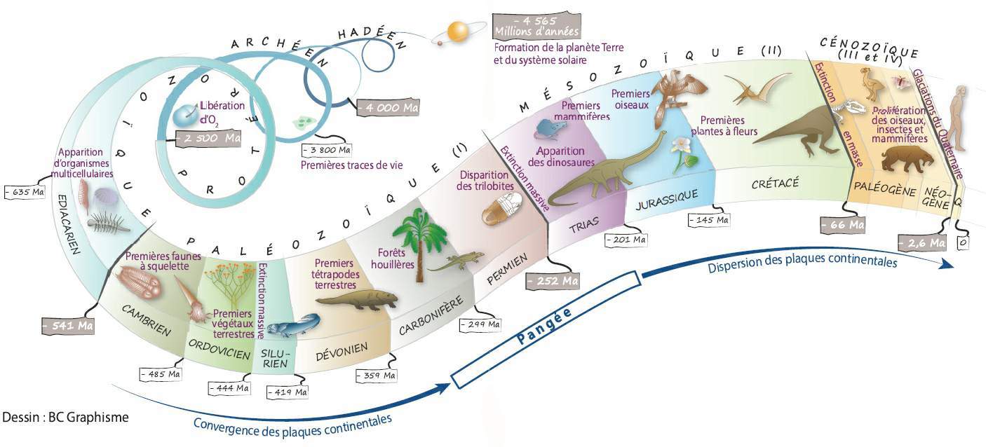
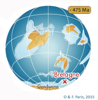
C’est en effet à partir de -475 millions d’années que s’est formé l’essentiel du sous-sol. À cette époque, la Bretagne était située sous la mer, près du pôle Sud, en bordure d’un méga-continent appelé Gondwana.
Les particules de sable et de vase transportées du continent vers la mer s’y sont déposées en couches successives. Compactées au fil du temps, elles se sont transformées en grès et en argilites. Quelques animaux marins, ainsi que les traces de leurs activités, ont en même temps été fossilisés.
Cette sédimentation marine, perturbée en presqu’île de Crozon par une activité volcanique (-448 millions d'années), s’est poursuivie sur près de 150 millions d'années, pendant la lente dérive du Gondwana vers le Nord. Près de 3 500 mètres d’épaisseur de sédiments se sont ainsi accumulés, en enregistrant des environnements marins périglaciaires (-444 millions d'année) puis tropicaux (-385 millions d'années).
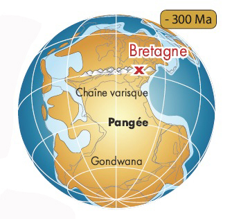
Vers -320 millions d'années, la collision entre les plaques Gondwana et Laurussia, lors de la constitution de la Pangée, a entraîné la formation d’une immense chaîne de montagnes (la chaîne varisque ou hercynienne) dont les sommets pouvaient atteindre 4 000 mètres d’altitude en Bretagne.
Soumises à d’énormes pressions tectoniques, les roches de la future presqu’île se sont plissées et facturées. Tout en perdant leur horizontalité initiale, les couches sédimentaires se sont transformées : les grès ont évolué en quartzites et les argiles en schistes.
Depuis lors émergée, cette imposante chaîne de montagnes a été érodée, puis à nouveau fracturée lors de l’ouverture de l’océan Atlantique (-180 millions d'années)
Les fluctuations du niveau marin, dues à l’alternance d’épisodes glaciaires et tempérés au Quaternaire (de -2.6 millions d'années à nos jours) ont enfin dessiné le trait de côte de cet ancien massif (le Massif armoricain), dont les plus hautes collines avoisinent aujourd’hui les 400 mètres d’altitude.
👉 Histoire géologique de la presqu'île de Crozon en dessins.
Sources : https://www.reservepresquiledecrozon.bzh
English.
Crozon Peninsula boasts a shoreline carved out of many strata of sedimentary rock dating back to the Paleozoic Era.

In fact, most of its subsoil was formed some 475 million years ago (mya). At that time, Brittany was under water, close to the South Pole, at the edge of a supercontinent called Gondwana.
Particles of sand and mud carried from the continent out to the sea were deposited there in successive layers. Compacted over time, they gradually transformed into sandstone and mudstone. Some sea animals along with traces of their activities, were fossilized at the same time.
This marine sedimentation, that was disrupted by volcanic activity on Crozon Peninsula (448 mya), continued over the course of nearly 150 million years (myr), during Gondwana’s slow drift northwards. Nearly 3,500 meters of sediments accumulated in depth, where both periglacial and then tropical marine environments were recorded (444 and 385 mya, respectively).
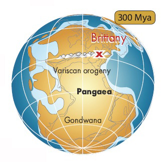
Around 320 mya, the collision of the Gondwana and Laurussia plates, during the assembly of Pangea, led to the formation of an immense mountain range (the Variscan or Hercynian orogeny) whose peaks stood as high as elevation of 4,000 meters in Brittany.
Subjected to tremendous tectonic pressure, the rocks of the future peninsula folded and farctured. Whilst losing their initial horizontality, the sedimentary layers were transformed : the sandstone evolved into quartzite and the mudstone into shale.
After emerging, the imposing mountain range eroded and then fractured again at the time of opening of the Atlantic Ocean (180 mya).
Fluctuations in the sea level, caused by the alternating glacial and tempered episodes of the Quaternary period (from 2.6 mya to the present day), finally drawing the coastline of the ancient Armorican mountain range, whose tallest hillsides now rise to altitudes of around 400 meters.
👉 Geologic timeline illustrations of Crozon peninsula (only in french).
Sources : https://www.reservepresquiledecrozon.bzh
Postolonnec
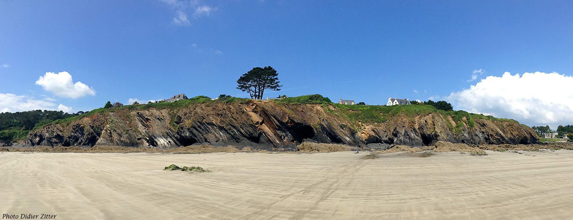
Les falaises de Postolonnec offrent une coupe dans des archives sédimentaires marines. Les fossiles d’animaux marins et les structures sédimentaires qui s’y trouvent ont permis aux géologues de mettre en évidence plusieurs cycles de variation du niveau marin, survenus sur 20 millions d’années. Les schistes sombres témoignent d’une période où le niveau marin était haut (dépôt de vases fines en milieu calme et profond) tandis que les grès clairs traduisent un épisode de bas niveau marin (dépôt de sable en milieu agité et peu profond).
En raison de la qualité des affleurements, cette coupe géologique a été choisie comme localité type pour définir la « Formation de Postolonnec » (-470 à -453 Ma).
EN : The cliffs of Postolonnec provide a cross-section of marine sedimentary archives. The fossils of marine animals and the sedimentary structures found there have allowed geologists to highlight several cycles of sea level variation that occurred over 20 million years. The dark shales show a period when the sea level was high (deposition of fine mud in a calm and deep environment) while the light sandstones indicate an episode of low sea level (deposition of sand in an agitated and shallow environment).
Due to the quality of the outcrops, this geological section was chosen as a typical locality to define the "Postolonnec Formation" (470 to 453 mya).

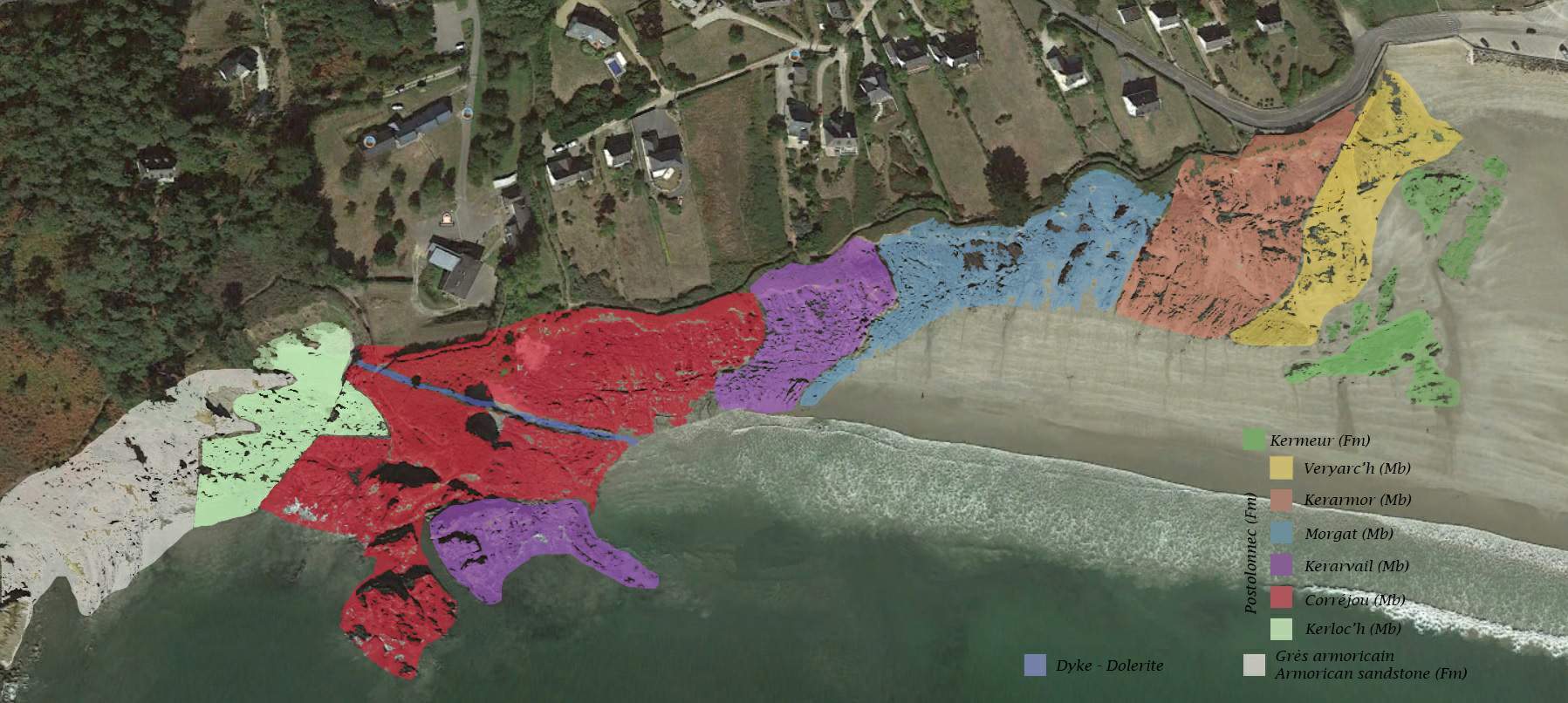
La formation de Postolonnec est encadrée à l’Ouest par des grès armoricains d’âge floien, cette zone est difficilement accessible, et à l’Est par les grès de Kermeur d’âge katien. Si, depuis le stationnement, vous vous dirigez vers l’Ouest de la plage et au-delà, vous allez remonter le temps de 20 Ma et de 17 Ma pour la formation de Postolonnec. Cette formation est divisée en six membres qui prennent des appellations locales :
- membre du Veryac’h ;
- membre de Kerarmor ;
- membre de Morgat ;
- membre de Kerarvail ;
- membre de Corréjou ;
- membre de Kerloc’h.
EN : The Postolonnec formation is bordered to the west by Armorican sandstones of Floian age, this zone is difficult to access, and to the east by Kermeur sandstones of Katian age. If, from the parking, you walk towards the West of the beach and beyond, you will go back in time 20 myr and 17 myr for the Postolonnec formation. This formation is divided into six members who take local names:
- Veryac'h Member;
- Kerarmor Member;
- Morgat Member;
- Kerarvail Member;
- Corréjou Member;
- Kerloc'h Member.
Quelques concepts
Ichnofossile :
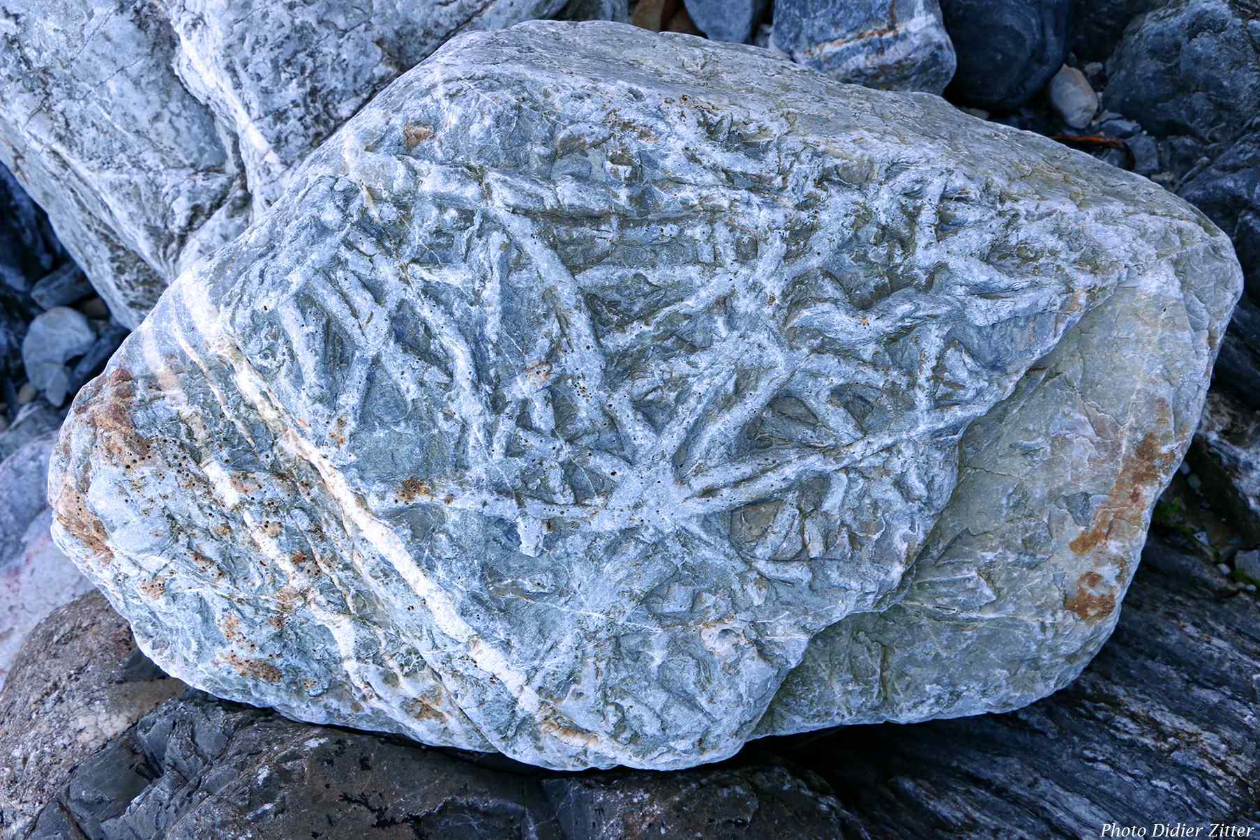
Un ichnofossile est le produit d'un organisme en interaction avec un milieu dans un environnement qui génère une structure physique tridimensionnelle. Les ichnofossiles sont des traces d'activité biologique qui ont été fossilisées. Il peut s'agir de pistes trahissant des déplacements, d'habitats (terriers, etc.), de traces de forages mécaniques ou biochimiques (roches, coquilles, etc.), ou autres (repos, prédation, déjections, restes d'œufs, etc.).
Ichnogenre :
Groupe d’ichnofossiles (traces fossiles) auquel on donne un nom car la similitude des traces suggère qu'elles ont été faites par des espèces d'organismes étroitement liés. Comme pour la classification classique (linnéene), les noms obéissent aux règles du code international de nomenclature zoologique (nom latin en italique dont la première lettre en majuscule) Exemple : Planolites, Teichichnus…
Description des Planolites :
Terriers simples, non alignés, non ramifiés, cylindriques ou subcylindriques, remplis, droits ou légèrement courbés, horizontaux ou obliques par rapport aux plans de litage (plan de l'ensemble des strates). Les terriers peuvent se croiser. Probablement dûs à divers organismes fouisseurs invertébrés, dont des vers et des insectes.
Ichnoespèce :
Nom d’espèces attribué aux ichnofossiles d’un même ichnogenre. Comme pour l’ichnogenre, les noms obéissent aux règles du code international de nomenclature zoologique (nom latin en italique qui suit l’ichnogenre) Exemple : Planolites monatus, Planolites annularus…
Ichnocénose :
Une ichnocénose est un groupement d’ichnofossiles qui sont l'œuvre d'une seule communauté d'organismes responsables de traces. Une ichnocénose est une unité hiérarchique de niveau inférieur par rapport à un ichnofascié. Elle est utile pour comprendre les facteurs physico-chimiques qui ont contrôlé la distribution et l'abondance des ichnofossiles en question.
Ichnofaciès :
Un ichnofaciès est une association de traces fossiles (ichnofossiles) qui fournit une indication des conditions dans lesquelles leurs organismes de formation ont vécu. Les ichnofaccies peuvent fournir des informations sur la profondeur, la salinité, la turbidité et l'énergie de l'eau. Ils permettent aussi de caractériser l’environnement de dépôt : oxygénation, vitesse de sédimentation… Par exemple l’association Planolites / Teichichnus, encore appelée association Cruziana permet de définir un environnement marin ouvert.
EN: Few concepts

Ichnofossil:
An ichnofossil, or trace fossil, is the product of an organism interacting with a medium in an environment that generates a three-dimensional physical structure. Ichnofossils are traces of biological activity that have been fossilized. They can be traces of movements, habitats (burrows, etc.), traces of mechanical or biochemical drilling (rocks, shells, etc.), or others (resting, predation, excreta, remains of eggs, etc.).
Ichnogenus:
A group of ichnofossils (trace fossils) that is given a name because the similarity of the traces suggests they were made by closely related species of organisms. As for the classical classification ( linnaean), the names follow the rules of the International Code of Zoological Nomenclature (Latin name in italics with the first letter in capital letters). Example: Planolites, Teichichnus…
Description of Planolites :
Simple, unlined, unbranched cylindrical or subcylindrical infilled burrows, straight to gently curved, horizontal to oblique to bedding planes (plan of all strata). Burrows may cross-over. Probably caused by various invertebrate burrowing organisms including worms and insects.
Ichnospecies:
A species name assigned to trace fossils within an ichnogenus. As for the ichnogenus, the names follow the rules of the International Code of Zoological Nomenclature (Latin name in italics following the ichnogenre) Example: Planolites monatus, Planolites annularus…
Ichnocoenosis:
An ichnocoenosis is an assemblage of ichnofosille, or trace fossils, that are the work of a single community of tracemaking organisms. An ichnocoenosis is a lower level hierarchical unit compared to an ichnofacies It is useful for understanding the physicochemical factors that controlled the distribution and abundance of the trace fossils in question.
Ichnofacies:
An ichnofacies is an assemblage of trace fossils (ichnofossils) that provides an indication of the conditions that their formative organisms inhabited. Ichnofacies can provide information about water depth, salinity, turbidity and energy. They also allow to characterize the deposition environment: oxygenation, sedimentation rate... For example, the Planolites / Teichichnus association, also called Cruziana association, allows to define an open marine environment.
Références – References
Le Paléozoïque de la presqu’île de Crozon, Massif Armorican
KU Ichnology - Studying trace of life
Ichnotaxinomie et notion d’ichnoespèce - Ichnotaxonomy and ichnospecies
Ichnofacies
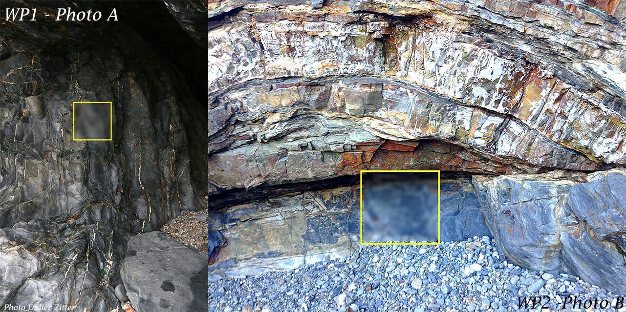
Vous allez vous diriger vers le membre du Veryac’h et vous arrêter au point de passage n°1 pour la première étape. Vous observerez les traces dans partie rectangulaire de la photo A. Puis vous vous dirigerez vers le point de passage n°2 pour la deuxième étape. Vous observerez les traces de la partie rectangulaire de la photo B
EN : You will go to the Veryac'h member and stop at the waypoint n°1 for the first step. You will see traces in the rectangular part of photo A. Then you will go to the waypoint n°2 for the second step. You will see traces of the rectangular part of photo B
Pour valider la cache – Questions
- Quelle est l’âge (en années) de la formation de Postolonnec ?
- Quelle est la différence entre un ichnofossile, une ichnocénose et un ichnofaciès ?
- À l’étape n°1, sur la roche de la paroi (cf photo A), décrivez ce que vous voyez ?
- À l’étape n°2, sur la roche de la paroi (cf photo B), décrivez ce que vous voyez ?
- Selon vous, les traces découvertes à l’étape 2 sont-elle similaires (même genre) à celles découverte à l’étape n° 1 ?
- Les mêmes organismes ont-ils produits ses traces ? Qu’en concluez-vous ?
Une photo de vous, de votre GPS ou de toute autre mascotte, prise dans les environs, sera la bienvenue, mais n’est pas obligatoire. Merci de ne pas publier de photos qui donneraient des indices.
Marquez cette cache « Trouvée », envoyez-nous vos propositions de réponses, en précisant bien le nom de la cache, soit via notre profil, soit via la messagerie geocaching.com (centre de messagerie). Nous vous répondrons en cas de problème. « Trouvée » sans réponses sera supprimée.
Il est strictement interdit de ramasser tout minéral, roche, fossile, galet, plante… sur tout le littoral. Merci de respecter cette consigne.
Logging requirements – Questions
- What is the age (in years) of the Postolonnec formation?
- What is the difference between an ichnofossil, an ichnocenosis and an ichnofacies?
- At step n°1, on the rock of the wall (see photo A), describe what you see?
- At step n°2, on the rock of the wall (see photo B), describe what you see ?
- According to you, are the traces discovered in step 2 similar (same genre) to those discovered in step 1?
- Did the same organisms produce these traces? What do you conclude from this?
A photo of you, your GPS or any other mascot, taken in the area is welcome but is optional, Please do not include pictures that will give clue for any of the question.
Log this cache "Found it", and send us your answers, don't forget to mention the name of the cache, via our profile or via geocaching.com (Message Center). We will answer you in case of problem. "Found it" without the anwers will be deleted.
It is strictly forbidden to pick up any mineral, rock, fossil, pebble, plant... all over the coast. Please respect this instruction.