

Introduction
Avec cette Earthcache, après avoir décrit rapidement la géologie de la région du Havre, nous allons nous intéresser à des thalassinoïdes (un réseau de terriers fossiles).
Géologie de la région du Havre
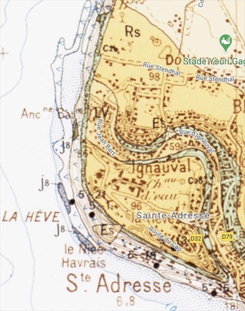
La région Le Havre-Étretat occupe l'extrémité SW du Pays de Caux. D'une grande uniformité morphologique, elle est formée par un plateau crayeux, de 100 m d'élévation environ, limité brutalement par une falaise à l'Ouest et au NW le long de la mer, et au Sud le long de la vallée de la Seine.
Les principaux affleurements que l’on peut observer sont du Crétacé. Le Jurassique n'affleure qu'à la base de la falaise maritime et n'est représenté que par le Kimméridgien (jurassique supérieur). Le Crétacé inférieur présente, sur une quarantaine de mètres, des faciès sablo-argileux et le crétacé supérieur (du Cénomanien au Sénonien), est entièrement crayeux. Le Tertiaire n'est représenté que par la formation à silex, provenant en partie de l'altération de la craie, et par des poches de sables marins et continentaux qu'elle renferme. Une épaisse couverture de limons quaternaires couronne la série (RS,Lv,Es).
De haut en bas :
c2b. Crétacé - Cénomanien moyen et supérieur. Il forme, au nord du Havre, la majeure partie de la falaise entre le Cap de la Hève et Saint-Jouin- Bruneval. C'est une série de craie jaunâtre à gros rubans de silex noirs, contrastant avec la craie sans silex du Turonien inferieur et l'ensemble marneux sombre du Cénomanien inférieur et de l'Albien sous-jacents. Son épaisseur est d'environ 35 m en bordure de la Seine.
c2a-1. Crétacé - Cénomanien inférieur, Vraconnien, Albien. Sous la craie à silex, on trouve une série peu épaisse (15 m au maximum) de grès, argiles et marnes dans laquelle les limites d'étages sont assez floues.
n6-1. Crétacé - Néocomien. Il est visible au pied de la falaise du Cap de la Hève, sous le phare.
j8. Jurassique - Kimméridgien. Il affleure sporadiquement au pied de la falaise et sur la plage parmi les éboulis et les galets, entre Le Havre et Heuqueville.
Au Cap de la Hève, affleure, à la base de la falaise, une alternance de bancs calcaires gris clair et de bancs argileux ; de haut en bas :
- Un banc à aspect conglomératique, de marne gris vert et de nodules calcaires (30 cm);
- Des marnes gris vert foncé
- De minces bancs calcaires espacés de 50 cm environ ; ces bancs deviennent plus épais vers le bas : il s'agit d'un calcaire gris clair comportant de nombreux terriers (vers, traces de Lithophages, crustacés décapodes fouisseurs, … ?).
Les thalassinoïdes
La paléoichnologie (la science des traces anciennes) est le domaine de la paléontologie étudiant exclusivement les traces d'activité biologique fossilisées (ichnofossiles).
Il peut s'agir de pistes trahissant des déplacements d’animaux (empruntes), d'habitats (terriers, etc.), de traces de forages mécaniques ou biochimiques (roches, coquilles, etc.), ou autres (déjections, restes d’œufs, etc.).
Les thalassinoïdes, étudiés pour la première fois en 1830, correspondent à un réseau de terriers fossiles. Ce réseau est horizontal complexe en labyrinthe principalement produits par des crustacés décapodes. Les galeries sont remplies de sédiments légèrement différents de l'encaissant dans lequel ils ont été creusés. Suivant les duretés relatives entre le remplissage des terriers et l'encaissant, l'érosion met en saillie ces anciennes galeries, ou au contraire les transforme en sillons déprimés.
L'attribution à tel ou tel animal des thalassinoïdes est souvent très difficile. Par analogie avec ce qu'on voit de nos jours dans la nature, ils sont le plus souvent attribués à des crustacés décapodes fouisseurs, ce qui ne veut pas dire que les thalassinoïdes présentés ici sont forcément dus à des crustacés.
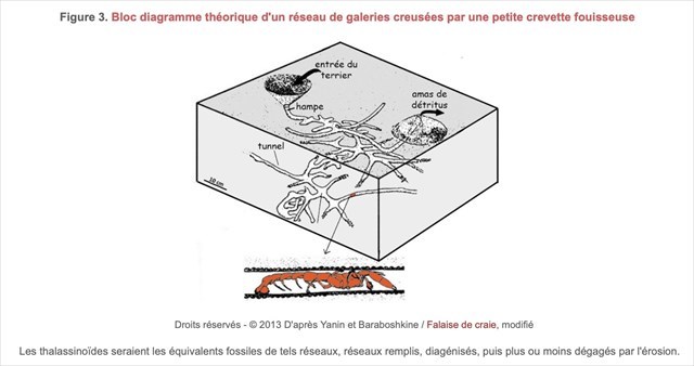
Les thalassinoïdes que nous allons étudiés sont de l'âge Jurassique supérieur.
Comme on peut le voir sur les 2 photos ci-dessous, les bancs calcaires contiennent d'innombrables thalassinoïdes. Ici, les terriers sont plus clairs et plus résistants à l’érosion que le calcaire encaissant.
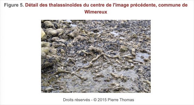
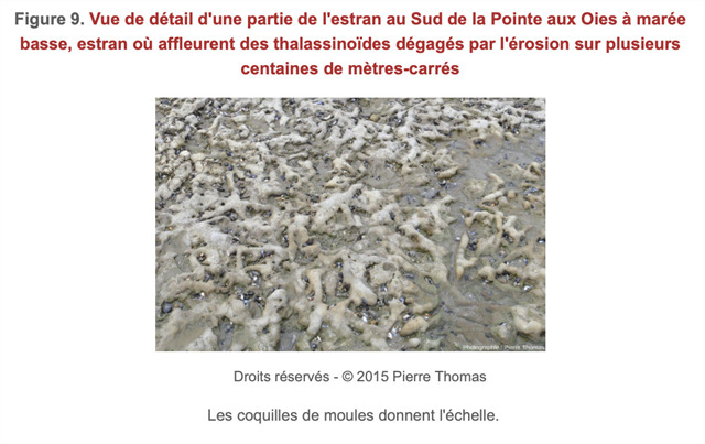
Comme dit plus haut, cela peut être le contraire comme on pourra l’observer au Cap de La Hève. C’est à dire, le remplissage des terriers est plus sombre et moins résistant à l'érosion que le calcaire encaissant, et ces terriers correspondent aujourd’hui à des sillons.
Analogie avec un terrier de crustacés fouisseurs
Afin de faire une analogie avec un terrier creusé par des crustacés fouisseurs, F. Fromard va reconstituer l’intérieur d’un de ces terriers en utilisant la technique mise au point par G. Fiorelli vers 1860 pour les fouilles de Pompéi.
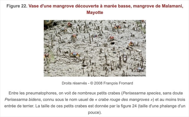
Ainsi il coule un mélange de résine liquide et d’un durcisseur dans les entrées d’un terrier. Une fois sec, il déterre le moulage du réseau de terriers.
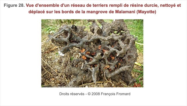
En observant la photo suivante où l’on montre le résultat d’un de ces moulages, cette comparaison montre qu'attribuer les thalassinoïdes à des terriers de crustacés fouisseurs anciens est parfaitement légitime.
Les sources bibliographiques
- http://ficheinfoterre.brgm.fr/Notices/0074N.pdf
- https://www.futura-sciences.com/planete/definitions/paleontologie-ichnofossile-14065/
- http://www.astrosurf.com/pablanchard/Encyclo/ICHNOFOSSILES.pdf
- https://infoterre.brgm.fr/fiche-registry/thesaurus.php?ncl=fostra
- https://fr.wikipedia.org/wiki/Paléoichnologie
- https://planet-terre.ens-lyon.fr/image-de-la-semaine/Img641-2019-05-20.xml
- https://www.sciencephoto.com/media/412573/view
- https://fr.wikipedia.org/wiki/Schistes_de_Wheeler
Pour valider la Earthcache
ATTENTION, les éléments à découvrir sur cette Earthcache se trouvent sur une zone protégée et fragile. Respectez-la ! Cette Earthcache est accessible à marée basse.
Loguez cette cache "Found it" et envoyez-moi vos propositions de réponses, soit via mon profil, soit via la messagerie geocaching.com (Message Center), et je vous contacterai en cas de problème. Les logs enregistrés sans réponses seront supprimés.
Rappel concernant les Earthcaches : Il n'y a pas de conteneur à rechercher ni de logbook à renseigner. Il suffit de se rendre sur les lieux, de répondre aux questions et de me renvoyer les réponses.
Etape 0 : ajouter à votre log une photo de vous, de votre GPS ou de votre pseudo sur la plage. Cette photo permettra de valider le « Found it » en cas de mauvaise réponse aux questions suivantes. Les photos donnant les réponses aux questions seront supprimées.
Question 1 : Au Cap de la Hève, affleure, à la base de la falaise, une alternance de bancs calcaires gris clair et de bancs argileux. De quelle période géologique date ces affleurements ?
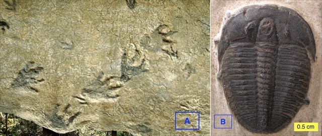
Question 2 : Parmi les photos A et B, laquelle est un ichnofossile ? Justifier votre réponse.
Question 3 : au WP1 (N49° 30.675’ E00° 03.966’). Vous êtes à proximité d’une des bandes de calcaire gris clair avec des traces plus foncées de terriers encaissants. Maintenant, pouvez-vous me décrire brièvement ce que vous voyez sous le carré rouge ? De quoi s’agit-il ?


Introduction
With this Earthcache, after briefly describing the geology of the Le Havre region, we will focus on thalassinoids (a network of fossil burrows).
Geology of the Havre region
The “Le Havre-Etretat” region occupies the SW end of the Pays de Caux. Of great morphological uniformity, it is formed by a chalky plateau, about 100 m high, abruptly limited by a cliff to the West and NW along the sea, and to the South along the Seine valley.
The main outcrops that can be observed are Cretaceous. The Jurassic only outcrops at the base of the sea cliff and is represented only by the Kimmeridgian (Upper Jurassic). The Lower Cretaceous has sandy-clayey facies for about 40 meters and the Upper Cretaceous (Cenomanian to Senonian) is entirely chalky. The Tertiary is represented only by the flint formation, partly resulting from the alteration of the chalk, and by the pockets of marine and continental sands it contains. A thick blanket of quaternary silts crowns the series (RS,Lv,Es).
From top to bottom:
c2b. Cretaceous - Middle and Upper Cenomanian. It forms, north of Le Havre, most of the cliff between Cap de la Hève and Saint-Jouin- Bruneval. It is a series of yellowish chalk with large black flint ribbons, contrasting with the flintless chalk of the Lower Turonian and the underlying dark marly ensemble of the Lower Cenomanian and Albian. Its thickness is about 35 m along the Seine.
c2a-1. Cretaceous - Lower Cenomanian, Vraconnian, Albian. Beneath the flint chalk is a thin series (15 m maximum) of sandstone, clays and marls in which the floor boundaries are rather blurred.
n6-1. Cretaceous - Neocomian. It is visible at the foot of the cliff of Cap de la Hève, under the lighthouse.
j8. Jurassic - Kimmeridgian. It outcrops sporadically at the foot of the cliff and on the beach among scree and pebbles, between Le Havre and Heuqueville.
At Cap de la Hève, at the base of the cliff, outcrops an alternation of light gray limestone banks and clayey banks; from top to bottom:
- A bench with a conglomeratic aspect, of gray-green marl and calcareous nodules (30 cm);
- Dark grey green marls
- Thin calcareous banks spaced about 50 cm apart; these banks become thicker towards the bottom: it is a light grey limestone with many burrows (worms, traces of Lithophagus, burrowing decapod crustaceans, ...?).
Thalassinoids
Paleoichnology (the science of ancient traces) is the field of paleontology studying exclusively the traces of fossilized biological activity (ichnofossils).
These may be tracks indicating the movements of animals (borrowed), habitats (burrows, etc.), traces of mechanical or biochemical drilling (rocks, shells, etc.), or others (excrement, remains of eggs, etc.).
Thalassinoids, first studied in 1830, correspond to a network of fossil burrows. This network is a complex horizontal labyrinthine network mainly produced by decapod crustaceans. The galleries are filled with sediments that are slightly different from the surrounding environment in which they were dug. Depending on the relative hardness between the filling of the burrows and the surrounding environment, erosion causes these old galleries to protrude or, on the contrary, transforms them into depressed furrows.
The attribution of thalassinoids to a particular animal is often very difficult. By analogy with what we see nowadays in nature, they are most often attributed to burrowing decapod crustaceans, which does not mean that the thalassinoids presented here are necessarily due to crustaceans.
The thalassinoids that we will study are from the Upper Jurassic age.
As can be seen on the 2 photos (see French description), the limestone banks contain innumerable thalassinoids. Here, the burrows are clearer and more resistant to erosion than the surrounding limestone.
As said above, it can be the opposite as can be observed at Cap de La Hève. That is to say, the filling of the burrows is darker and less resistant to erosion than the surrounding limestone, and these burrows correspond today to furrows.
Analogy with a burrow of burrowing crustaceans
In order to make an analogy with a burrow dug by burrowing crustaceans, F. Fromard will reconstruct the inside of one of these burrows using the technique developed by G. Fiorelli around 1860 for the Pompeii excavations.
Thus, it pours a mixture of liquid resin and hardener into the entrances of a burrow. Once dry, it digs out the molding of the burrow network.
By observing the following photo showing the result of one of these casts, this comparison shows that attributing thalassinoids to ancient burrowing crustacean burrows is perfectly legitimate.
Bibliographical sources
- http://ficheinfoterre.brgm.fr/Notices/0074N.pdf
- https://www.futura-sciences.com/planete/definitions/paleontologie-ichnofossile-14065/
- http://www.astrosurf.com/pablanchard/Encyclo/ICHNOFOSSILES.pdf
- https://infoterre.brgm.fr/fiche-registry/thesaurus.php?ncl=fostra
- https://fr.wikipedia.org/wiki/Paléoichnologie
- https://planet-terre.ens-lyon.fr/image-de-la-semaine/Img641-2019-05-20.xml
- https://www.sciencephoto.com/media/412573/view
- https://fr.wikipedia.org/wiki/Schistes_de_Wheeler
To validate the Earthcache
WARNING, the elements to be discovered on this Earthcache are on a protected and fragile area. Respect it ! This Earthcache is accessible at low tide.
Log in this cache "Found it" and send me your proposed answers, either via my profile or via geocaching.com (Message Center), and I will contact you in case of problem. Logs recorded without answers will be deleted.
Reminder about Earthcaches: There is no container to look for and no logbook to fill in. Just go to the site, answer the questions and send the answers back to me.
Step 0: add to your log a photo of you, your GPS or your nickname on the beach. This photo will validate the "Found it" in case of wrong answer to the following questions. The photos giving the answers to the questions will be deleted.
Question 1: At Cap de la Hève, an alternation of light gray limestone banks and clayey banks outcrop at the base of the cliff. From what geological period do these outcrops date?
Question 2: Among pictures A and B, which one is an ichnofossil? Justify your answer.

Question 3: in WP1 (N49° 30.675' E00° 03.966'). You are near one of the light grey limestone bands with darker traces of surrounding burrows. Now, can you briefly describe what you see under the red square? What is it all about? What is it about?
