陰陽海位於北部濱海公路旁,因此處海水終年呈現黃藍相間的景色而被取名做陰陽海。陰、陽,是源自於古代中國哲學思想的一種二元論觀念。古代中國把事物中對立又聯合的現象,例如天地、日月、晝夜、寒暑等,用「陰陽」的概念來加以表述,從中彰顯出「相互對立又依存」的抽象關係。
Yin-yang Sea is located beside the northern coastal road. The name "Yin-yang Sea" is due to the sea water's color being chequered with yellow and blue all the time. Yin and yang is a concept that comes from Chinese philosophy which describes how seemingly opposite or contrary forces may actually be complementary, interconnected, and interdependent in the natural world, and how they may give rise to each other as they interrelate to one another (e.g. sky and ground, sun and moon, day and night, etc.).
當地居民一度認為是台灣金屬礦業公司的礦廠治煉所造成的汙染導致了陰陽海的顏色,然而,即便礦廠已關閉超過二十年,海水的顏色依舊。如果不是汙染導致了海水顏色的變化,那是什麼讓這裡的海水顏色變得如此不同呢?
The local residents believed that sea color was the result of the pollution from Taiwan Metal Mining Corp's smelting activities. However, the company has been closed for over twenty years with no activities, the color of the sea is still no changed. If it was not the pollution that caused the color of the sea, then why is the color of the sea different here?
Distribution and Origin of Rocks in Jinguashi Area / 金瓜石地區岩石分布與成因
Before understanding the cause of the Yin Yang Sea, we must first understand the surrounding environment. When we have a better understanding of the geological background of the Jinguashi area, we will be closer to the cause of Yin Yang Sea.
在了解陰陽海的成因前,我們要先了解一下周遭的環境。當我們更了解金瓜石地區的地質背景我們就離陰陽海的成因更進一步了。
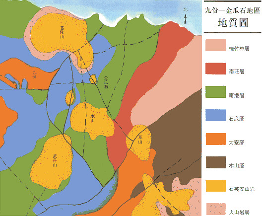
The main rock masses in the Jiufen-Jinguashi area are sedimentary rocks containing sandstone, shale and some carbon layers. These rock layers were formed on the seabed about 25-10 million years ago.
九份-金瓜石地區的主要岩體為包含砂岩、頁岩及部分碳層的沉積岩,這些岩層是在約2500~1000萬年前在海底堆積形成的。

Magmatism occurred in this place 1.7 million years ago, forming several Intrusive igneous rocks masses and extrusive igneous rocks masses; including three main intrusive rock masses of Keelung Mountain, Ben Mountain and Wudan Mountain, as well as two extrusive rock masses of Cao Mountain and Jimuling The above igneous rocks are mainly composed of andesite.
在170萬年前這個地方發生了岩漿活動,形成數個火成岩的侵入岩體與噴出岩體;包括基隆山、本山、武丹山等三個主要侵入岩體,以及草山、雞母嶺兩個噴出岩體,上述火成岩主要都是由安山岩構成。
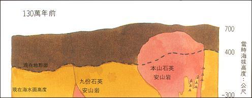
At about the same time or later when magma invaded and formed igneous rocks, the hot water ore liquid surged along many north-south faults and many parallel small faults and fracture zones nearby. "hydrothermal mineralization" occurred, forming a gold mine in this area. Later, some east-west faults were formed, cutting through the original north-south mineralization belt. Along these east-west faults, later hydrothermal mineralization occurred.
約在岩漿侵入、形成火成岩的同時或稍晚,熱水礦液沿著許多南北向斷層及附近許多平行小斷層和破碎帶上湧。發生「熱水礦化作用」,形成了此地區的金礦體。後來又生成一些東西向的斷層,切過原先的南北向礦化帶。沿著這些東西向斷層,又產生了較後期的熱水礦化作用。
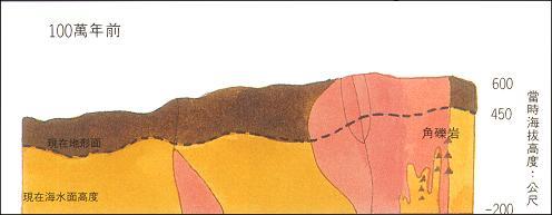
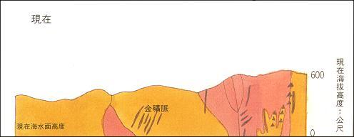
The minerals in the Jinguashi area were roughly formed in this way. After that, due to the continuous tectonic movement, the area continued to rise. Therefore, the ore bodies in the deep underground can be lifted to the current altitude together with the surrounding rock. The thicker overburden rock in the upper part was also removed due to erosion during this million years, causing some of the ore bodies to be exposed to the surface, and even many shallow ore bodies were washed into rivers by rain . Therefore, traces of placer gold can be found in the streams near Jiufen-Jinguashi and even the Keelung River.
金瓜石地區的礦物大致便是如此形成的,之後由於持續進行的構造運動,使得這個地區持續地上升。因此深藏地底的礦體才能夠連同圍岩整個被抬升到現在的海拔高度。上部原來較厚的覆蓋岩層,也在這一百萬年之間,因侵蝕作用而被除移,使得部份礦體露出地表,甚至有許多淺部礦體的礦物被雨水沖到河川之中。因此,九份-金瓜石附近的溪流,甚至遠達八堵的基隆河,都可以發現砂金的蹤跡。
Hydrothermal Mineralization / 熱水礦化作用
From the section above, we know that the geological changes in the Jinguashi area came from magmatic activities, and one of the keys is hydrothermal mineralization, so what is hydrothermal mineralization?
由上段中我們知道金瓜石地區的地質產生變化是來自於岩漿活動之後,而其中的一個關鍵便是熱水礦化作用,那麼什麼是熱水礦化作用呢?
The volcanic activity itself will bring some hydrothermal fluids. The hot igneous rock mass will heat the groundwater. This hot water dissolves the mineral components in the igneous rock mass and surrounding sedimentary rocks in the deep under high pressure to form a hot mineral liquid; The faults and fracture zones in igneous or sedimentary rocks rise to a shallower place. When the temperature and pressure are gradually reduced, the minerals dissolved in the hydrothermal fluid will be released and precipitated in the fissures or rock fractures, resulting in hydrothermal mineralization effect.
火山活動本身會帶來一些熱液,炙熱的火成岩體會加熱地下水,這些熱水在高壓的地底深處大量溶解火成岩體及周圍沉積岩中的礦物成分,形成熱水礦液;熱水礦液若順著火成岩或沉積岩內的斷層、破碎帶上升到較淺處,當溫度與壓力逐漸降低後,熱液中溶解的礦物便會釋出,並在裂隙或岩縫中沉澱下來,產生熱水礦化作用。
In the upwelling process of hot water, in addition to mineralization, the hot water with high temperature and strong acid often reacts physically or chemically with rocks to change the texture of the rock, which is called in geology. This is the "Alteration." In the Jinguashi area, there are three common types of exchanges caused by hot water: "silication", "argillization", and "propylitization"
熱水礦液在上湧的過程中,除了會產生礦化作用之外,高溫強酸的熱水礦液也常和岩石發生物理或化學反應,使岩石的質地產生改變,在地質學上稱之為「換質作用」。金瓜石地區由熱水礦液引起的換質作用常見的有3種:「矽化作用」、「黏土化作用」、「綠泥石化作用」。

Causes of Yin Yang Sea / 陰陽海的成因
After the introduction above, we have learned how the ore bodies in the Jinguashi area were formed, so how did the magical phenomenon like the Yin Yang Sea occur?
在經過了上述的介紹之後我們已經了解到金瓜石地區的礦體是怎麼形成的,那麼到底是怎麼產生陰陽海這樣的神奇現象的呢?
Jinguashi is located at the northeastern tip of Taiwan. The rainy season in spring and summer, the typhoon in summer and the northeast monsoon in autumn and winter bring abundant rain to this area. The rainwater flows through the cracks on the surface of the mining area and penetrates into the mine site, and contacts with the iron sulfide minerals (pyrite, sulphur-arsenic copper) contained in the rock mass of the mining area to form highly acidic mineral water.
金瓜石位於台灣東北端,春夏交替的梅雨、夏季的颱風及秋冬的東北季風,為這個地區帶來充沛的雨水,這些雨水流經礦區表層裂縫滲進礦場,與礦區岩體中含有的硫化鐵礦物(黃鐵礦、硫砷銅礦)接觸形成高酸性礦水。
After the mineral water in various mining areas has gathered and flowed out, it flows down due to the terrain drop and because the water is rich in heavy metal ions and strong acidity (pH=2.6), plants are not easy to grow, and waterfalls and exposed stream beds are formed. You could observe this kind of phenomenon at Golden Waterfall (waypoint 1) and Liandong River (waypoint 2). When these mineral waters flow into streams, they contact with air or river water, further oxidize and produce yellow-brown sediments.
各處礦區的礦水匯集流出後,因地勢落差而往下沖刷,並且因為水中富含的重金屬離子及強酸性(pH=2.6),使植物不易生長,乃形成瀑布與裸露的溪床,即是在黃金瀑布(觀察點1)與濂洞溪(觀察點2)看到的景觀。而這些礦水在流入溪流中時,與空氣或河水接觸,進一步氧化並產生黃褐色的沉澱物。
A large amount of mineral water flows into the sea through the Liandong River. When these strong acid mineral water and iron oxide deposits come into contact with alkaline seawater, they will further produce a stronger reaction to precipitate iron ions into suspended solids. And, a large amount of suspended iron oxide floating on the surface of the sea, the yellow and blue phases are like yin and yang. So, the phenomenon of Yin Yang Sea is formed.
大量礦水經由濂洞溪流入海中,這些強酸礦水與氧化鐵的沉澱物在接觸到偏鹼性的海水時會進一步產生更強烈的反應使鐵離子被析出變成懸浮物,大量的氧化鐵懸浮物浮在海面上,便形成了黃藍相間的陰陽海現象。
To log this cache, please answer the following questions:
- If there is no magma invasion, how will the view of three places (posted coordinates, waypoint 1 and waypoint 2) be different from now? Why is that?
如果沒發生岩漿入侵,各觀察點的景觀會跟現在有什麼差異?為什麼?
- Are there any areas where magmatic activities (e.g. Datun volcanoes, Guanyin volcanoes) have a chance to have the same phenomenon as the Jinguashi area or also rich in mineral resources? Please explain your answer and explain the reason why.
同樣有經歷岩漿活動的地區(例如:大屯火山群、觀音火山)是否有機會發生如同金瓜石地區一樣的現象或是蘊含豐富的礦物資源?請說明你的答案並解釋原因。
- Please compare the type of stones (e.g are the characteristics the same?), and the metal concentration on the surface of the stone at three observation places: Golden Waterfall (waypoint 1), Liandong Stream Bed (waypoint 2), Outlet to the Sea (posted coordinates), and please try to explain the reasons that caused the difference.
請比較三個觀察點(黃金瀑布、濂洞溪床及出海口)的石頭類型(例:是否有相同特徵?)與石頭表面的金屬濃度,並嘗試說明造成這些狀態的原因。
- If there had never been any mining activity here, would the color of the sea water be different from today? Please explain your thoughts.
如果這裡從未有過任何採礦活動,海水的顏色會跟如今有所不同嗎?請說明並解釋你的答案。
- Take a photo with the Yinyang Sea in the background (please check the reference points if you're interested, that two places are nice spot for taking photos of YinYang Sea), the photos must contain either you (no face required), your personal item, a piece of paper with your geocaching name, or any else that would makes your photos unique.
請以陰陽海為背景,拍照上傳。
Notes:
- Please don’t post any answers in your log.
- Please send the answers to the owner via message system of geocaching.com. Only the accounts that sent the answers could log as found, so please make sure you sent your own answers even you’re in the group-hunting.
- You MUST visit the earthcache location to claim a find. I’ll delete the logs of people who clearly didn’t visit the earthcache or who didn't complete the logging tasks.
- You don’t have to wait the permission to log after you send the answers. Any logs without all of the answers will be deleted.
REF: 黃金之島(玉山社出版), 地球科學園地(1997, 第二期), 金礦體的生成, 愚人金—黃鐵礦,告訴您金瓜石金礦的聰明事