🌏 Welcome to the Jade Mountain Earth Cache! 🌏
In this Earth Cache, you will go on a journey back in time, many, many eons ago. (Well, maybe not that far back but don’t worry, because you will come back to the present time rather quickly.) As we travel in our geological/earth science time machine, you will be briefly introduced to plate tectonics and how they created the most stunning mountain peaks here in Taiwan. Then you will learn about the main focus of this Earth Cache — Glacier Erosion. You will learn about what a glacier is and how glaciers have played a very significant role in the shaping of mountains, particularly the highest mountain in Taiwan — Jade Mountain, which is the highest mountain peak along the Tropic of Cancer where there is evidence of Quaternary glaciation! (Don’t worry. "Quaternary glaciation" will be explained in more detail a little later on.) Upon learning all there is to know about glaciers and their force of sculpting, you will be ready to put on your Earth Science Caps and get geological here at the highest peak in Taiwan! And after you answer the task questions and complete all your Glaciological Studies and Observations (which can all be found at the bottom of this page), you can log a “Found It!” for this Earth Cache. I hope you enjoy! Let’s get into our time machines now . . .
|
Background Information to the Formation of Jade Mountain:
Let's go on a little journey back in time, a time before you and I. A time before things like smart phones or planes were even imaginable. A time before Geocaching was even here! But a time when some sort of treasure hunting was probably in existence. Yes, let’s go on a journey many, many millions of years in the past. We have a front row seat to watch the main event — The Philippine Plate vs. The Eurasia Plate — two superpowers of “puzzle pieces” that lie way beneath the Earth and like to change things up a bit in the topographical sense. We are going to witness something like never before seen. We are going to get a firsthand glimpse into the wonders that Mother Nature creates.
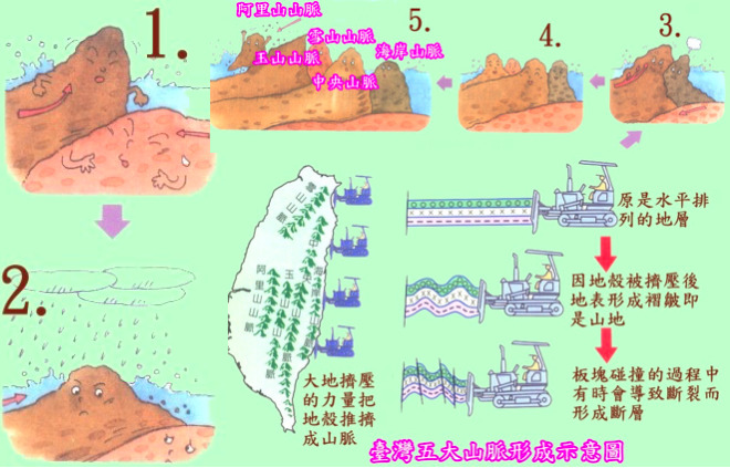
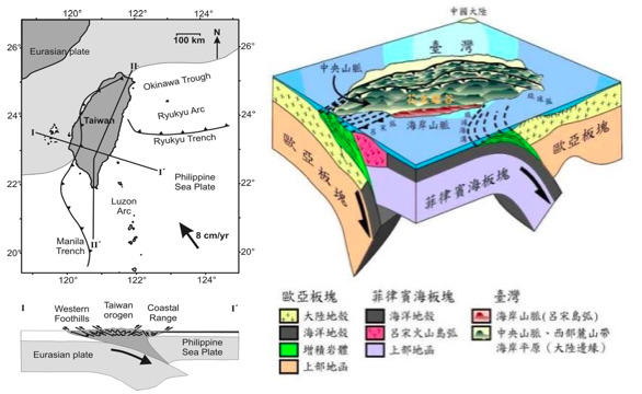
As we get situated into our front row seats, it isn’t long before The Philippine Plate and The Eurasia Plate start to “disagree” about their locations. It appears that one wants to claim a new territory in the Pacific Ocean. The “clashes" between the two superpowers of the ocean floor start to occur and things escalate rather quickly. It isn’t just about a few bumps here and there. No, Mother Nature is going full force and unleashing her magic along the Pacific like no other. Below is a little image to help give you a little picture of what is going on:

As we watch the action unfold before our very eyes, we see the convergence and subsequent subduction of these beasts of the “underworld” — The Philippine Plate and The Eurasia Plate converge with one another or rather collide quite intensely, causing a part of The Eurasian Plate to subduct or slip under The Philippine Plate along the 120 E longitude from 22.9 N. Because of these sheer forces of Mother Nature unleashing havoc upon the ocean floor, rocks that are located some tens of kilometers deep below the surface of the Earth are awaken and pushed up from their abysmal abodes. They travel from their subterranean dwellings up, up and up, reaching the surface of the Earth. You can’t believe your eyes as these sunken geological wonders come from beyond the depths of the Earth and rise far above the land. What were once buried rock some 20, 30, 50 kilometers below the surface of the Earth now make their grand appearance upon the land, but they don’t just come in a few small groups of itty, bitty rock that form tiny hills or mounds. No, these rocks are pushed up nearly 4,000 meters above the Earth, and thus making Taiwan the island nation we know topographically as today — the land with the largest concentration of mountain peaks over 3,000 meters, which makes Taiwan a unique gem of The Pacific where beauty astounds and adventure awaits. Below are a few more diagrams to help visualize more of all the tectonic action that has been unfolding:
|
So, you may wonder or ask, "What is so significant about all this? I mean, so what? A bunch of rocks from many, many kilometers below the Earth get pushed up super high and now we have mountains?"
Well, for starters, imagine how huge these mountains actually are. If you include their subterranean sections, we get a mammoth of a beast of a mountain! That is pretty impressive in itself wouldn't you say?
And two, the real game changer here, which is the star of the show — glacial erosion. Yep, you read that right. Taiwan is home, or rather has been home, to glaciers. And Jade Mountain — geologically unique peak here in Taiwan — is the highest point on the Tropic of Cancer and the only point on that circle of latitude where there is any evidence of Quaternary glaciation. Or in other words, Jade Mountain was pushed up from beyond the depths of the ocean millions of years ago but only just "recently" was carved and shaped into the mountain we know it as today since Quaternary glaciation means the ice age we are living in now! So there you have it! That's why Jade Mountain is of interest not just topologically and geologically, but also of interest for us to explore on a whole new level today — glacially modified
|
Introduction to Quaternary Glaciation and its Significance to Jade Mountain
So to understand what "Quaternary Glaciation" is, first think of how humans have different stages or milestones of their life — like infant, teen, adult. Humans have unique moments or stages in their life and just like the Earth. And the Earth’s milestones have similarly been divided into different stages or events along a timeline known as the Geological Time Scale. Different events on this timeline may include for example the first appearance of animals on Earth, or the formation of mountains. Or another event on this Geological Time Scale, which is the focus of this Earth Cache is “ice ages”. Basically the ice ages refer to a time when there were many glaciers forming across the Earth due to colder temperatures. One particular ice age of interest as mentioned above is known as Quaternary glaciation — a period that began some two million years ago and is still going on to this day. Basically this period is marked by an alternating between glacial and interglacial periods — the former meaning colder than normal temperatures and the latter meaning warmer than normal temperatures. During this Quaternary glaciation period, ice sheets have appeared, and during glacial periods they have expanded. And during interglacial periods they have contracted. This is significant since we are now living in an “ice age” — one where we are experiencing “extreme temperatures from super cold to super hot. The major effects of Quaternary glaciation is the erosion of land and the deposition of material all over the land, which causes longterm landscape modification.
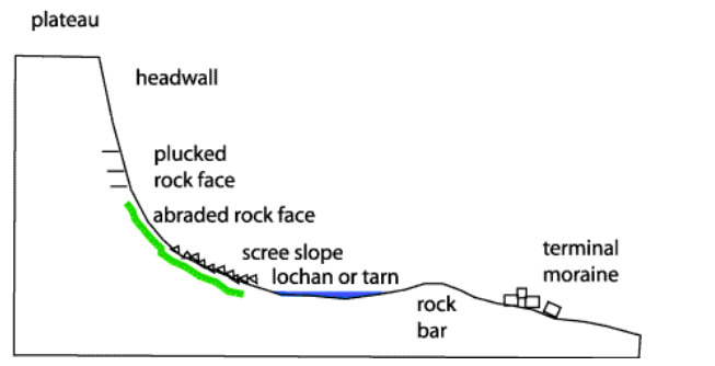
Jade Mountain stands at 3,952 meters above sea level and is a treasure trove of geological excitement as it is the only place along the Tropic of Cancer latitudinally where you can witness the effects of Quaternary glaciation, which, as stated above, are how this mountain changed its appearance due to the "Modern Ice Age" that we are experiencing and living in right now every day of our lives! So, Jade Mountain may have been created millions of years ago but was only recently sculpted by the ice age we live in now! Below is a simple diagram to understand a few of the major landforms created by Glaciers and some of the ones you will see here in, on, and around Jade Mountain:
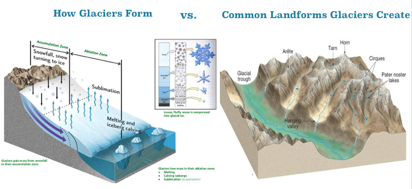
Arête: a thin, crest of rock left after two adjacent glaciers have worn a steep ridge into the rock
Horn: usually a sharp-edged peak that forms when glaciers erode three or more arêtes
Cirque: concave, circular basins carved by the base of a glacier as it erodes the landscape.
Spur: a smaller ridge branching off a summit or a main ridge.
Tarn a lake formed by the melting water of a glacier
Col a rounded low point near the center of the ridgeline.
Combe a small valley
Glacial step: a steep area of raised land above a valley
Hanging valley: a "side" or "brach" valley that usually sits on top of the main valley
U-shape trunk valley a bowl-shaped valley
|
Now that we understand Quaternary glaciation, and how this period is the Modern Ice Age we are all living in now, let us dive into how glaciers specifically helped in sculpting Jade Mountain into the peak we have come to admire.
|
How "Modern Glaciers" Turned Jade Mountain into a Masterpiece of Mother Nature:
Before getting into the Michelangelo's manipulation upon Jade Mountain, it is important to first understand a little bit about glaciers themselves. Simply put, glaciers are slow-moving pieces of ice. They formed because of snow accumulating and then compacting. Glaciers not only transport material as they move, but they also sculpt and carve away the land beneath them. A glacier's weight, combined with its gradual movement, can drastically reshape the landscape over hundreds or even thousands of years as it did (and possible will continue to do) to Jade Mountain. The ice erodes the land surface and carries the broken rocks and soil debris far from their original places, resulting in some interesting glacial landforms, a few of which can be viewed below:

As stated earlier, Jade Mountain is unique in that it is the highest point on the Tropic of Cancer where there is any evidence of Quaternary glaciation, which, to reiterate, means the Modern Ice Age we are experiencing daily has made Jade Mountain what it is today.
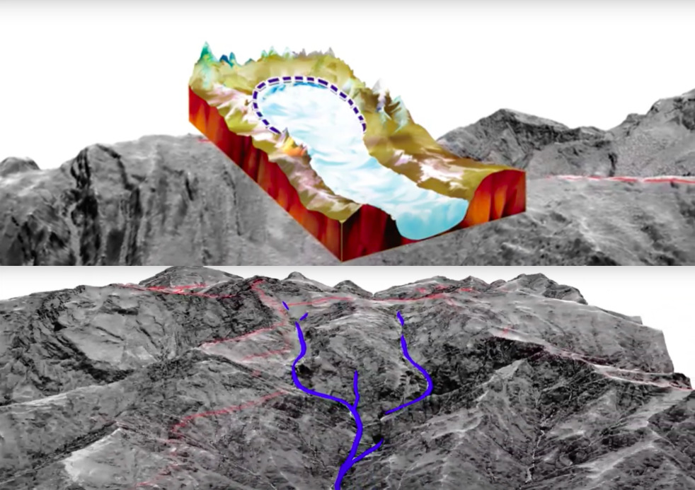
In the diagram below, the top photo shows remnants where of a glacier formed at the top of Jade Mountain. Glaciers usually form near the tops of mountains so it can be said that mountain peaks are the "birthplace" of glaciers, as is the case here in Jade Mountain. As the glacier continues to accumulates more and more snow and thus becoming heavier, it will start to slowly move down the mountain, freezing in places and then "thawing" out again, taking some of the rocks along the mountain wall with it, as illustrated in the bottom image of the photos below. This repeated action of snowing, falling, freezing and thawing will eventually result in the creation of something known as a glacier cirque, which is an amphitheatre-like shape or bowl-like depression on the side of the mountain. This concave shape is present here and the features are consistent with what glacier erosion will do to the land, thus concluding that Jade Mountain has been carved by glaciation.
Another characteristic of glaciation here at Jade Mountain is the presence of roche moutonnée, which is simply a "rock hill" that has a smooth top and plucked, or worn away, sides due to the direction of the glacier ice moving across the affected area.
Below is a diagram comparing the formation of a glacial cirque to a roche moutonnée:

One last thing to note to prove the existence of glaciers upon Jade Mountain is the presence of erratics, which are basically rocks or boulders that shouldn't be there. What do I mean? Well, you may recall from above that a glacier will pluck away at the mountain it flows or skids across on and take with it goodies galore and transport them to a new location. Included in this goody bag that glaciers transport are of course rocks. As a glacier loses its momentum and strength, it can't continue to carry so many things, especially rocks, so it "drops" them off along its journey before continuing onward or retreating back to its starting point. Because the rocks were carried to a new location, they obviously differ from the other rocks that were already there to begin with. This "anomaly" or this out-of-place "strangeness" of a rock proves that the rock is in its "wrong" home because it is different in appearance and different geologically from all the other nearby rocks. Jade Mountain is home to some of these erratics and if you look closely you can find the ones that stand out. Below is a diagram to help illustrate erratics. (Please note that an erratic can be any shape or size.)
|
Logging Requirements:
Jade Mountain is definitely a one-of-a-kind geological wonder carved by glaciers here in Taiwan, and at the Posted Coordinates as well as the one Referenced Waypoint (WP 01) you will see the unique landforms that were shaped by the forces of Mother Nature, and at the same time, get a glimpse into this mountain's rich geological history, not only from the perspective of millions of years ago but also from a more "recent" period — The Modern Ice Age! (aka " Quaternary glaciation). So let's get back into our time machines and propel ourselves back the present and get ready to do some fun observations and tasks related to Earth Science here at the highest point along the Tropic of Cancer — Jade Mountain!
In order to log a Found It! for this Earth Cache, please go to the Posted Coordinates and the one additional Referenced Waypoint (WP 01) to complete the following tasks:
1. Based on what you have learned about glaciers and the landforms they create, what features can you observe at the Posted Coordinate that indicate the presence of glacial erosion upon Jade Mountain? How did you come to this (these) conclusion(s)?
2.Walk around the peak in the four directions — North, East, South, and West. While maintaining a safe distance and practicing the utmost safety at all times, near the "end" of those directions, estimate the "angle of drop" at each extremity there at the peak. In other words, the peak of Jade Mountain is a flat "plateau-like" landform where cliffs or sharped-angle edges are at every corner. Observe where the "end" of the flatness is and the angle of drop begins and estimate those "angles of drop". Based on what you have learned about glacial movements and based on your observations and the on-site angle-measurement task, what do your findings indicate about how the glacier eroded the land? In which direction was the "most damage" made? What about the least? How did you come to these conclusions?
3. Based on your observations at the Posted Coordinates, and based on what you have learned about glaciers, what glacial-eroded landforms, if any, were not able to be observed? In other words, why do you feel some "common" landforms created by glaciers were not present here at Jade Mountain? (Hint: The Peak of Jade Mountain is a "flat" or "plateau" place. Why?) How did you come to this (these) conclusion(s)?
4. At the peak, search for two stones that are similar in size but different in appearance. If possible, pick them up and pay attention to their weight. Do the two stones that are different in appearance have similar weight? What about their texture? How do the two stones feel? As you are carrying out this on-site task, is that different stone unique from all the other stones in the area or is there an abundance of similarly looking stones around? Based on all these observations here at the Posted Coordinates, and based on this on-site task you have just completed about the stones, would you say that the different stone is an erratic? How were you able to come to this conclusion? Why do you feel the erratics are at that particular location you observed? Or, if you are unable to identify or observe any erratics what could be the reason for the lack of erratics?
5. At Waypoint 1, you can observe from a different angle more glacial erosion and the landforms created by such forces there along the peak of Jade Mountain. Based on your observations here at Waypoint 1, and based on what you have learned about glaciers and their direction of travel, again, in what direction do you feel the glacier traveled to create such landforms? Was this direction the same as the one you concluded in Task 2? In other words, were your initial observations at the Posted Coordinates about the movement of glaciers consistent to what you can observe at Waypoint 1? If the observations about glacial movement are similar, how did you come to this conclusion? If the observations are inconsistent or different, why do you feel there is this discrepancy?
6.Based on all your observations during the tasks above, and based on your knowledge of glaciers and the landforms they create, if you could "reverse engineer" this mountain, what do you think it originally looked like? In other words, we know Jade Mountain came into existence millions of years ago during the converging and subduction of the Philippine Plate and Eurasia Plate, but it was just shaped or sculpted "recently" during this Quaternary glacial period. So how did this mountain original look before the glaciation period came and reshaped it? How did you come to this conclusion?
7. Post a photo of yourself or a "Geocaching" item identifying yourself at the Posted Coordinates.
You may log a Found It! on this cache after you have completed the tasks and emailed me the answers. If there are any issues with your answers, I will contact you. And as a friendly reminder, please do not post any of the answers in your logs. Thank you for visiting this Earth Cache. I hope you enjoy your time on Jade Mountain!