
Cette cache n'est pas accessible en cas de crue du ruisseau
This cache is not accessible in case of flooding of the stream

click on the flag to reach the translation
Une Earthcache
Il ne s’agit pas d’une cache physique. Pour loguer cette cache, vous devez dans un premier temps prendre connaissance de sa description éducative en matière de géologie, puis d’observer le site sur lequel vous êtes, et enfin de répondre aux questions qui vous seront posées.
Vous pourrez alors loguer en "Found it" sans attendre mais vous devez me faire parvenir vos réponses en même temps en me contactant soit par mail dans mon profil, soit via la messagerie geocaching.com (Message Center), et je vous contacterai en cas de problème. Les logs enregistrés sans réponses seront supprimés.

Un peu de géologie
Le site
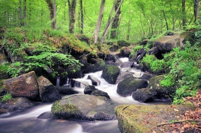
Situées sur la Vire, les cascades de Pont-es-Retours traduisent une forte dénivellation entre l'amont et l'aval, de l'ordre de 100 m sur 3 km, les cascades montrant elles-mêmes plusieurs ressauts sur 25 m de hauteur. Le remaniement de l'arène granitique est à l'origine de la formation d'un chaos pittoresque, utilisé historiquement comme carrière de granite
Une arène granitique
A l’échelle des temps géologiques, le granite peut se dégrader très rapidement d’autant plus que la vitesse de désagrégation du granit dépend du climat. L’altération du granite début généralement le long de fissures dans lesquelles l’eau pénètre. Dans un climat tempéré, elle conduit à la formation de boules de granite puis d’un chaos granitique avec la formation d’une arène granitique formée principalement de granis de quartz, mais aussi de micas altérés, de feldspaths pouvant évoluer jusqu’au stade d’argile kaolinique.
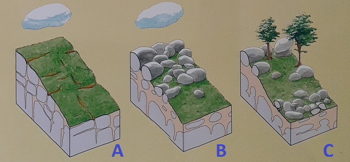 A) Granite sain fracturé recouvert d’un sol, infiltration d’eau de pluie dans les fractures du granite
B) Altération par l’eau du granite en arène granitique le long des fractures
C) Erosion et transport de l’arène par le ruissellement des eaux de pluie, les boules de granite restent sur place : formation d’un chaos granitique
Formation naturelle d'une cascade
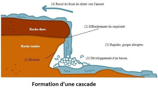
Sur un plan géologique, le phénomène appelé "cascade" est naturellement formé de la sorte
1) érosion de la roche tendre sous-jacente
2) effondrement de l’aplomb
3) développement d’un bassin
4) recul du front de chute de la rivière ou du torrent vers l’amont
5) formation d’une vallée abrupte en forme de gorge.

Questions
Question 0 - Prenez une photo de vous, ou de votre objet distinctif de géocacheur, ou de votre pseudo écrit sur une feuille de papier ou dans votre main... devant le cours du ruisseau, et joignez-là à votre log ou à vos réponses

Point d'observation principal - Rendez-vous au point d'observation principal (voir photo) au bord du ruiseau
Question 1 - Décrivez les rochers que vous voyez dans le lit du ruisseau (forme, couleur, dureté, présence de grains, ...)
Question 2 - Expliquez le phénomène géologique ici en présence

Point d'observation à gauche - Depuis le même point d'observation, face au ruisseau, tournez vous sur votre gauche et observez les zones ABC représentées sur la photo
Question 3 - Observez la surface du rocher A. En quoi diffère-t-elle de celle des autres rochers voisins ?
Question 4 - Tentez une explication qui serait uniquement due un à phénomène géologique
Question 5 - Observez le rocher B, qu'a-t-il de singulier ?
Question 6 - Sa présence, en termes purement géologiques, est-elle attendue ici ?
Question 7 - A quoi selon vous est liée la présence de ce rocher ?
Question 8 - Cette hypothèse peut-elle s'appliquer à A, donnant ainsi une autre explication à Q6 ?
Question 9 - Dirigez-vous maintenant vers le rocher C, attention à ne pas tomber ! Quelle est particularité de sa surface ?
Question 10 - A quoi pourrait être due la forme de ce rocher ?
Question 11 - En vous appuyant sur la formation naturelle géologique d'une cascade donnée par la leçon, sommes-nous ici en présence de cascades de la Vire ?

Point d'observation en retrait - Depuis le point d'observation initial, reculez-vous en retournant vers le sentier. Observez la zone D représentée sur la photo
Question 12 - Décrivez le "rocher" que vous voyez. Est-il originaire d'ici (ne vous précipitez pas dans la réponse, réfléchissez)?
Question 13 - Le lit de la Vire, à ce niveau, fait ainsi état de 2 différents types d'évolution du granite, quelles sont-elles?

An Earthcache
It is not a physical cache. To log this cache, you must first learn about its educational description in geology, then observe the site on which you are, and finally answer the questions that will be asked.
You can then log in "Found it" without waiting but you must send me your answers at the same time by contacting me either by mail in my profile, or via the messaging geocaching.com (Message Center), and I will contact you in case of problem. Saved logs without answers will be deleted.
A little of geology
The site
Located on the Vire, the Pont-es-Returns waterfalls reflect a steep drop in level between upstream and downstream, of the order of 100 m over 3 km, the waterfalls themselves showing several jumps out of 25 m high. The reworking of the granite arena is at the origin of the formation of a picturesque chaos, used historically as a granite quarry
A granite arena
On the geological time scale, granite can degrade very quickly, especially since the rate at which granite disintegrates depends on the climate. Weathering of granite usually begins along cracks where water enters. In a temperate climate, it leads to the formation of granite balls and then to a granitic chaos with the formation of a granite arena formed mainly of quartz granis, but also of altered micas, feldspars that can evolve to the stage of kaolin clay.
A) Healthy fractured granite covered with soil, infiltration of rainwater into the granite fractures
B) Water alteration of granite in granite arena along the fractures
C) Erosion and transport of the arena by the runoff of rainwater, the granite balls remain in place: formation of a granite chaos
Natural formation of a waterfall
On a geological level, the phenomenon called "cascade" is naturally formed in this way
1) erosion of the underlying soft rock
2) collapse of plumb
3) development of a basin
4) retreat of the front of the fall of the river or torrent towards the upstream
5) formation of a steep valley in the shape of a gorge.

Questions
Question 0 - Take a picture of yourself, or your geocacher signature, or your nickname written on a piece of paper or in your hand ... in front of the course of the stream, and attach it to your log or answers
Main observation point - Meet at the main observation point (see photo) at the edge of the stream
Question 1 - Describe the rocks you see in the creek bed (shape, color, hardness, presence of grains, ...)
Question 2 - Explain the geological phenomenon here in presence
Observation point on the left - From the same observation point, facing the stream, turn to your left and observe the ABC zones shown in the photo
Question 3 - Observe the surface of rock A. How does it differ from that of other nearby rocks?
Question 4 - Try an explanation which would be due solely to a geological phenomenon
Question 5 - Observe rock B, what is unique about it?
Question 6 - Is its presence, in purely geological terms, expected here?
Question 7 - What do you think the presence of this rock is related to?
Question 8 - Can this hypothesis be applied to A, thus giving another explanation for Q6?
Question 9 - Now head to rock C, be careful not to fall! What is special about its surface?
Question 10 - What could be the shape of this rock?
Question 11 - Based on the natural geological formation of a waterfall given by the lesson, are we here in presence of the Vire waterfalls?
Recessed observation point - From the initial vantage point, step back and return to the trail. Observe area D shown in the photo
Question 12 - Describe the "rock" you see. Is he from here (don't rush into the answer, think about it)?
Question 13 - The bed of the Vire, at this level, thus reports 2 different types of granite evolution , what are they?