Ce site est surtout connu pour ses cascades, qui sont un élément incontournable du bassin millavois.
Par contre, les falaises qui jouxtent le site sont moins connues, et pourtant, le sentier qui les serpentent, pour rejoindre le moulin du Tournal et un peu plus loin encore, sont une véritable invitation à la rêverie et la contemplation de part leur structure rocheuses uniques, en partie faite de tuf.
Pour rejoindre le départ, garez vous au parking de l’aire d’atterrissage des parapentes de Brunas, et suivez l’autre coté de la route la piste puis le sentier qui indique la direction du moulin de Tournal (petit panneau bois)
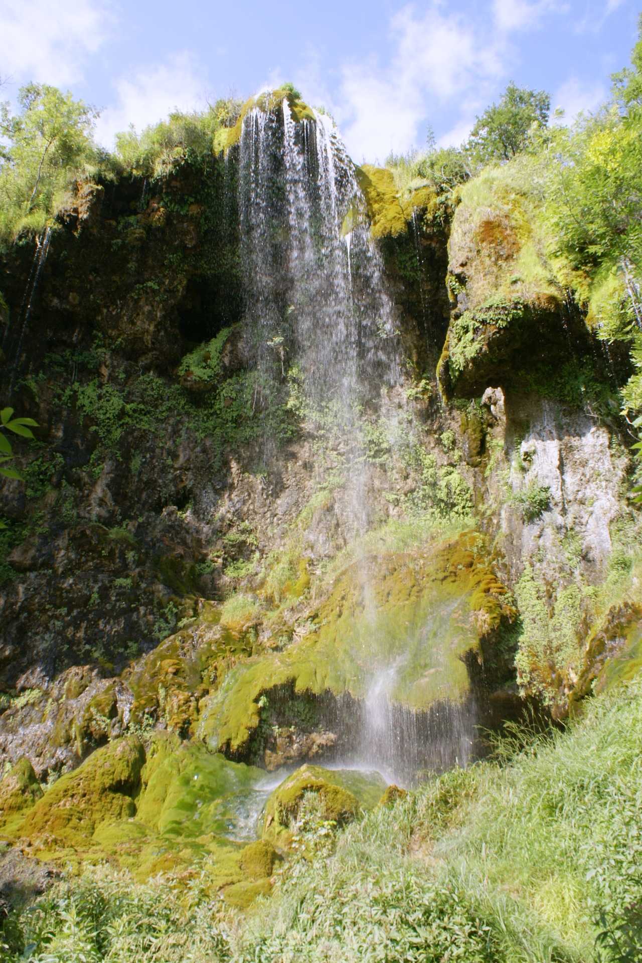
Les rivières de notre territoire sont marquées par le caractère karstique des Causses . Une alchimie magique entre l’eau et le causse (« le karst ») est à l’origine d’un des milieux les plus exceptionnels : le tuf.
Au sortir des résurgences, la précipitation du calcaire dissous dans l’eau produit des encroûtements, qui peuvent devenir de véritables barres rocheuses ou travertins. Ces barrage naturel formés par ce type de roche appelé tuf permet d’avoir de l’eau aux périodes où elle est rare et de ralentir l’écoulement des eaux en période de crue. Il offre des zones de caches, d’abris, de reproduction pour la faune aquatique. La flore s’y développe et même parfois des espèces de mousses rares à l’échelle nationale.

Cette roche poreuse et légère à deux origines :
Le tuf calcaire qui provient de l'encroûtement par des carbonates de la végétation aquatique et des plantes riveraines (ce sera notre cas sur ce site remarquable).
Le tuf Volcanique qui résulte de la cimentation des dépôts et de l'accumulation de cendres d'origines volcaniques
Comment se forme ce dépôt calcaire ?
Les eaux de pluie sont peu minéralisées et contiennent une très faible quantité de gaz Carbonique. En traversant le sol, elles se chargent de ce Co2 produit par l'activité biologique des végétaux et des bactéries et pénètrent en profondeur. Dans le milieu naturel, la minéralisation de l'eau va donc évoluer en fonction de ses échanges avec la roche et l'atmosphère.
Lorsque l’eau a suffisamment dégazé, les particules de Calcium peuvent précipiter, c’est-à-dire passer du stade dissous (dans l’eau) au stade Cristallin (à l’air libre). Cette cristallisation se fait préférentiellement là où l’échange entre l’air et l’eau est maximal (comme les cascades). C’est un phénomène qui s’auto-entretient : plus il y a de cascades, plus il y a de dépôts et plus il y a dépôts, plus les cascades augmentent ! Il peut y avoir des concrétions, moins spectaculaires dans les lieux à écoulements plus lents.
Les Cristaux se déposent sous forme d’une croûte calcaire sur les végétaux présents dans le cours d’eau. Ce sont principalement les mousses et les algues qui servent de support. La superposition de ces couches successives forme le Tuf.

Qu’est-ce qui favorise la formation du tuf ?
La formation du tuf dépend de nombreux facteurs : des conditions bien particulières sont nécessaires pour que le carbonate de calcium précipite.
Une faible profondeur : Si le cours d’eau est très agité et peu profond, le contact entre l’air et l’eau est important, ce qui favorise la formation des tufs. Le tuf s’accumule préférentiellement sur les obstacles, entraînant la formation de barrages s’amplifiant progressivement au fil du temps.
La température de l'eau et le climat tempéré du milieu vont faciliter la formation du tuf. Une eau chaude contient plus de CO2et dissout plus de calcaire lors de son trajet souterrain. Elle transportera plus de calcium dissous et fabriquera plus de tuf.
L’ensoleillement , en permettant une meilleure croissance des végétaux, entraîne une surconsommation de CO2 et favorise ainsi la formation des tufs autour d’eux.
La présence de végétaux aquatiques : La présence de CO2 dissous dans l’eau favorise la croissance des végétaux. De fait, la précipitation du calcaire s’en trouve accélérée car ses derniers l’absorbent pour leur croissance. l’absorption du CO2 au cours de la photosynthèse favorise la précipitation du calcaire.
La présence d’embâcles (obstructions) : Les particules auront tendance à se déposer là où un obstacle rend le lit du ruisseau un peu moins profond ou encombré. Dans ce cas, l’eau coule plus vite et est plus agitée; elle se dégaze mieux favorisant ainsi la précipitation du calcaire.
pour de plus amples renseignements sur le tuf des Causses, je vous invite à aller lire le Fascicule du Parc Régional des Causses du Quercy
Je vous propose avec cette Earthcache, de parcourir ce sentier à flan de falaise et découvrir ou revoir toute la beauté de ces lieux et leurs particularités (attention, bien qu’étant très intéressantes à découvrir, certaines parties sont notifiées privées, donc éviter d’y accéder).
Pour loguer cette cache, il vous faudra rejoindre au fil de votre cheminement les PZ (points particuliers) proposés et répondre aux questions suivantes :
au PZ 1 :
1 - que voyez-vous de particulier sur cette paroi ?
Au PZ 2 :
2 – juste au dessus de la stucture cresée en formes de créneau, que pouvez-vous observer ?
Au PZ 3 :
3 – que pouvez-vous obverver à vos pieds et tout autour de vous?
Au PZ 4 : prenez une photo de vous avec l’écoulement de la Cascade derrière vous et le village en fond de tableau. Selon la saison et votre témérité, vous pouvez prendre une photo les pieds dans l’eau. Par contre, ne pas aller trop vers le bord car la cascade et très haute et cela peut représenter un risque.
Ensuite, Loguez cette cache "Found it" et envoyez-moi vos propositions de réponses soit via mon profil, soit via la messagerie geocaching.com (Message Center), et je vous contacterai en cas de problème.
Espérant que cette petite balade vous aura permet d’apprécier ce magnifique site.

This site is best known for its waterfalls, which are an essential part of the Millavois basin.
On the other hand, the cliffs which adjoin the site are less known, and yet the path that winds them, to reach the Tournal mill and a little further still, are a real invitation to reverie and contemplation due to their rocky structure. unique, partly made of tuff.
To reach the start, park in the parking lot of the Brunas paragliding landing area, and follow the other side of the road the track then the path which indicates the direction of the Tournal mill (small wooden sign)
The rivers in our territory are marked by the karstic character of the Causses. A magical alchemy between water and the causse ("karst") is at the origin of one of the most exceptional environments: tuff.
At the end of the resurgences, the precipitation of the limestone dissolved in the water produces crusts, which can become real rock bars or travertines. These natural dams formed by this type of rock called tuff provide water during periods when it is scarce and slow down the flow of water during flood periods. It offers hiding, shelter and reproduction areas for aquatic fauna. Flora thrives there and sometimes even species of mosses that are rare nationally.
This porous and light rock has two origins:
The limestone tuff which comes from the encrustation by carbonates of the aquatic vegetation and riparian plants (this will be our case on this remarkable site).
Volcanic tuff which results from the cementing of deposits and the accumulation of ash of volcanic origin
How is this lime deposit formed?
Rainwater is not very mineralized and contains a very small amount of carbon dioxide. By crossing the ground, they take charge of this Co2 produced by the biological activity of plants and bacteria and penetrate deeply. In the natural environment, the mineralization of water will therefore evolve according to its exchanges with the rock and the atmosphere.
When the water has sufficiently degassed, the calcium particles can precipitate, that is to say, pass from the dissolved stage (in water) to the crystalline stage (in the open air). This crystallization occurs preferentially where the exchange between air and water is maximum (such as waterfalls). This is a self-sustaining phenomenon: the more waterfalls, the more deposits and the more deposits, the more the waterfalls increase! There may be concretions, less spectacular in places with slower flows.
The crystals are deposited in the form of a calcareous crust on the plants present in the watercourse. It is mainly mosses and algae that serve as support. The superposition of these successive layers forms the Tuff.
What promotes the formation of tuff?
The formation of tuff depends on many factors: very specific conditions are necessary for the calcium carbonate to precipitate.
Shallow depth: If the stream is very agitated and shallow, the contact between air and water is important, which favors the formation of tuffs. Tuff preferentially accumulates on obstacles, resulting in the formation of dams which gradually amplify over time.
The temperature of the water and the temperate climate of the environment will facilitate the formation of tuff. Hot water contains more CO2 and dissolves more lime as it travels underground. It will carry more dissolved calcium and make more tuff.
Sunshine, by allowing better plant growth, leads to overconsumption of CO2 and thus promotes the formation of tuffs around them.
Presence of aquatic plants: The presence of CO2 dissolved in water promotes plant growth. In fact, the precipitation of limestone is accelerated because the latter absorb it for their growth. the absorption of CO2 during photosynthesis promotes the precipitation of limestone.
The presence of jams (obstructions): Particles will tend to settle where an obstacle makes the stream bed a little shallower or congested. In this case, the water flows faster and is more agitated; it degasses better thus promoting the precipitation of limestone.
for more information on the Causses tuff, I invite you to read the Fascicule du Parc Régional des Causses du Quercy
I suggest you with this Earthcache, to walk this path on the cliff side and discover or review all the beauty of these places and their particularities (be careful, although being very interesting to discover, some parts are notified private, so avoid to access).
To log this cache, you will need to join the proposed PZs (special points) as you go along and answer the following questions:
at PZ 1:
1 - what do you see in particular on this wall?
At PZ 2:
2 - just above the crenellated structure, what can you observe?
At PZ 3:
3 - what can you observe at your feet and all around you?
At PZ 4: take a photo of yourself with the flow of the Cascade behind you and the village in the background. Depending on the season and your recklessness, you can take a photo with your feet in the water. On the other hand, do not go too far towards the edge because the waterfall is very high and that can represent a risk.
Then, Log this "Found it" cache and send me your suggested answers either via my profile or via geocaching.com messaging (Message Center), and I will contact you in the event of a problem.
Hoping that this little walk will have enabled you to appreciate this magnificent site.