L'Escalier du Roi d'Aragon se trouve en mer Méditerranée, plus précisément au sud de la Pointe du Timon sur laquelle a été édifiée la citadelle de Bonifacio,
à la pointe Sud de l'« Île de Beauté.
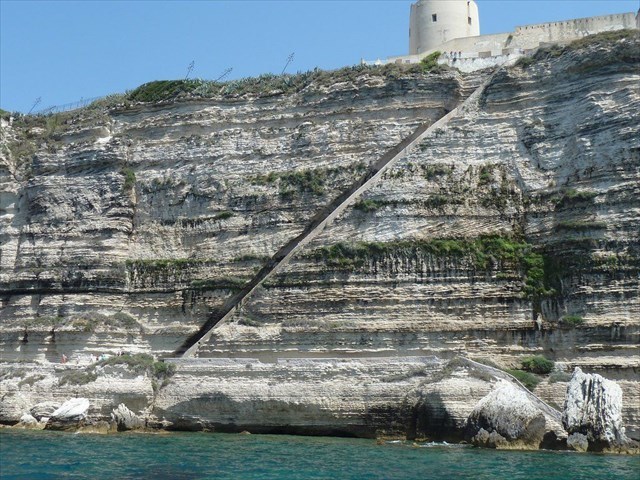
Vu de la mer, par bateau, il apparaît de loin comme un trait sombre en oblique, sur toute la hauteur à flanc de falaise,
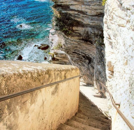
et de près comme un demi-tube évidé dans la pierre.
Coupé par des personnes directement dans les rochers calcaires de la falaise de Bonifacio, l’escalier comporte 187 marches et une inclinaison d’environ 45°. Une légende raconte qu’elle a été battue dans les rochers en une nuit par les troupes du roi d’Aragon Alfons V après le siège de Bonifacio 1420. Plus vraisemblablement, la construction a duré plus longtemps et a été réalisée par des Franciscains qui voulaient accéder à une source d’eau potable au pied des escaliers.
Die Treppe des Königs von Aragon befindet sich im Mittelmeer, genauer gesagt südlich der Pointe du Timon, auf der die Zitadelle von Bonifacio an der Südspitze der „Insel der Schönheit“ errichtet wurde.
Vom Meer aus gesehen, mit dem Boot, erscheint es von weitem wie eine dunkle schräge Linie, ganz oben auf der Klippenseite und ganz nah wie eine im Stein ausgehöhlte Halbröhre.
Von Menschen direkt in den Kalksteinfelsen der Kliffküste von Bonifacio geschnitten,
besteht die Treppe aus 187 Stufen und hat eine Neigung von ungefähr 45°.
Eine Legende besagt, sie sei in einer einzigen Nacht von Truppen des Königs von Aragon Alfons V. nach der Belagerung von Bonifacio 1420 in den Felsen gehauen worden.
Wahrscheinlicher ist, dass der Bau länger dauerte und durch Franziskaner erfolgte, die Zugang zu einer Trinkwasserquelle am Fuß der Treppe schaffen wollten.
The King of Aragon's staircase is located in the Mediterranean, more precisely south of the Pointe du Timon, on which the Bonifacio Citadel was built on the southern tip of the "Island of Beauty".
Seen from the sea, by boat, it appears from a distance like a dark oblique line, at the very top of the cliff side and very close like a half-tube hollowed out in the stone.
Cut by people right into the limestone cliffs of Bonifacio's cliff coast,
the staircase consists of 187 steps and has an inclination of approximately 45 °.
Legend has it that it was hewn out of the rocks in one night by troops of the King of Aragon Alfonso V after the siege of Bonifacio in 1420.
It is more likely that the construction took longer and was done by Franciscans who wanted to access a source of drinking water at the foot of the stairs.
--------------------------------------------------------------------------------------------------------------------------------------------------------------------------
Plateau corse-sarde:
La Corse faisait autrefois partie de la France métropolitaine avec la Sardaigne. Il y a environ 11,5 millions d'années au Tertiaire, avec la formation de la mer Méditerranée, la plaque corse-sarde s'est détachée du continent. Cette plaque a tourné de 45 degrés par rapport au continent italien et 5 millions d'années plus tard, elle s'est arrêtée, la Corse s'arrêtant un peu plus tôt. Dans le sud de la France, il y a des roches de formation et de localisation identiques, ce qui est prouvé par la rotation loin du supercontinent sur la base de données géomagnétiques et sismologiques. La réserve naturelle "Scandola", entre Calvi et Porto, était à cette époque à peu près à la hauteur de l'actuel Nice.
Korsisch-sardische Platte:
Korsika gehörte einst mit Sardinien zusammen zum französischen Festland. Vor ca. 11,5 Millionen Jahren im Tertiär, mit Entstehung des Mittelmeeres, kam es zur Abspaltung der korsisch-sardischen Platte vom Kontinent. Diese Platte rotierte um 45° Grad gegen das italienische Festland und 5 Millionen Jahre später kam es zum Stillstand, wobei Korsika etwas eher stoppte. In Südfrankreich kommen Gesteine in identischer Ausbildung und Lage vor, was die Rotation vom Urkontinent anhand von geomagnetischen und seismologischen Daten hinweg beweist. Das Naturschutzreservat „Scandola“, zwischen Calvi und Porto, lag damals wohl ungefähr auf Höhe vom heutigen Nizza.
Corsican-Sardinian platter:
Corsica was once part of the French mainland together with Sardinia. About 11.5 million years ago in the Tertiary, with the formation of the Mediterranean Sea, the Corsican-Sardinian plate split off from the continent. This plate rotated 45 degrees against the Italian mainland and 5 million years later it came to a standstill, with Corsica stopping a little earlier. In the south of France, rocks are found in identical formation and location, which is proven by the rotation away from the supercontinent on the basis of geomagnetic and seismological data. The nature reserve "Scandola", between Calvi and Porto, was at that time approximately at the height of today's Nice.
Types de roches en Corse:
Une spécialité de la Corse sont les creux de forme bizarre du granit. Ils sont appelés altération Tafoni (de Cors. Tafonare = évidement). Des mélanges alcalins dans le granit, sous l'influence de l'humidité, créent ces trous dans la roche, ce qui conduit à des formations rocheuses extraordinaires. Différents mélanges minéraux donnent au granit les différentes nuances de couleur. Le plus impressionnant dans la Calanche près de Piana sur la côte ouest, où les additifs porphyriques lui donnent une couleur rougeâtre. Les tours rocheuses escarpées des Aiguilles de Bavella, également appelées Dolomites corses, sont également intéressantes et belles à regarder.
Le relief diminue vers le sud. A Bonifacio, comme dans le nord de la Sardaigne, il existe un calcaire sablo-calcaire ou dolomitique sédimenté, probablement formé par dolomitisation secondaire de boues de chaux d'origine marine. Ces roches calcaires sont marquées de manière impressionnante par les marées et les tempêtes.
Gesteinsarten auf Korsika:
Eine Besonderheit auf Korsika sind die bizarr geformten Aushöhlungen des Granits. Sie werden Tafoni Verwitterungen genannt (von kors. tafonare = Aushöhlung). Alkalische Beimengungen im Granit lassen unter Einfluss von Feuchtigkeit diese Löcher im Gestein entstehen, was zu außergewöhnlichen Felsformationen führt. Verschiedene mineralische Mischungen geben dem Granit die unterschiedlichen Farbschattierungen. Am beeindrucktesten in der Calanche bei Piana an der Westküste, bei der Porphyrzusätze für eine rötliche Einfärbung sorgen. Interessant und schön anzuschauen sind auch die schroffen Felstürme der Aiguilles de Bavella, die auch als die korsischen Dolomiten bezeichnet werden.
In Richtung Süden nimmt das Relief ab. Bei Bonifacio erhebt sich, wie im Norden Sardiniens, Kalksandstein beziehungsweise sedimentierte Dolomit-Kalke, die vermutlich durch sekundäre Dolomitisierung von Kalkschlamm marinen Ursprungs entstanden. Diese Kalkfelsen sind von den Gezeiten und Stürmen eindrucksvoll gezeichnet.
Rock types in Corsica:
A specialty of Corsica are the bizarrely shaped hollows of the granite. They are called Tafoni weathering (from Cors. Tafonare = hollowing out). Alkaline admixtures in the granite, under the influence of moisture, create these holes in the rock, which leads to extraordinary rock formations. Different mineral mixtures give the granite the different color shades. Most impressive in the Calanche near Piana on the west coast, where porphyry additives give it a reddish color. The craggy rock towers of the Aiguilles de Bavella, also known as the Corsican Dolomites, are also interesting and beautiful to look at.
The relief decreases towards the south. At Bonifacio, as in the north of Sardinia, there is a sand-lime stone or sedimented dolomite limestone, which was probably formed by the secondary dolomitization of lime sludge of marine origin. These limestone rocks are impressively marked by the tides and storms.
Formation de pierre dolomitique - dolomitisation
La dolomitisation est le terme pour les processus diagénétiques qui conduisent à la formation de roches dolomitiques (pierre dolomitique ou simplement dolomite). On ne sait toujours pas comment se forme la dolomite; on suppose que la dolomite est formée à partir de calcaire ou de roches calcaires dans une phase diagénétique précoce et tardive.
Dans la phase initiale, la calcite est transformée en dolomite contenant du magnésium au moyen de l'eau de mer, grâce à quoi les caractéristiques structurelles du calcaire, telles que la stratification et les fossiles, sont conservées. L'évaporation continue des solutions salines augmente la teneur en magnésium et favorise ainsi la diagenèse; il n'est pas rare que des dolomites se forment en couches alternées avec des roches salées. Cela crée également de minuscules cristaux de dolomite.
Dans le diagnostic tardif, qui a lieu en dehors de la mer à travers des eaux contenant du magnésium dans du calcaire solidifié, les cristaux de calcite sont remplacés métasomatiquement par la dolomie minérale (longeron de magnésium), les caractéristiques structurelles d'origine disparaissent, la stratification fine et les fossiles sont généralement absents. La roche dolomitique résultante est typiquement massive et a une structure à gros grains. Les cristaux de dolomite qui en résultent sont plusieurs fois plus gros que lors du diagnostic précoce.
La conversion du calcaire en dolomite conduit à une diminution de volume allant jusqu'à 13%, ce qui se remarque par une porosité accrue. Ou, plus la roche est dolomitisée, plus sa porosité est grande.
Entstehung von Dolomitstein - Dolomitisierung
Dolomitisierung ist der Begriff für diagenetische Prozesse, welche zur Bildung von Dolomitgestein (Dolomitstein oder nur Dolomit) führen. Es ist bis heute noch nicht eindeutig geklärt, wie Dolomit entsteht; man nimmt an, dass Dolomit aus Kalkstein oder kalkhaltigen Gesteinen in einer diagenetischen Früh- und in einer Spätphase gebildet wird.
In der Frühphase wandelt sich Calcit mittels Meerwasser in Magnesium-haltigen Dolomit um, wobei die Gefügemerkmale des Kalksteins, wie Schichtung und Fossilien, erhalten bleiben. Duch fortlaufende Eindunstung von Salzlösungen erhöht sich der Magnesiumgehalt und fördert damit die Diagenese; nicht selten entstehen Dolomite in Wechsellagerung mit Salzgesteinen. Hierbei entstehen auch winzige Dolomitkristalle.
Bei der Spätdiagenese, welche außerhalb des Meeres durch Magnesium-haltige Wässer in verfestigtem Kalkstein stattfindet, werden Calcitkristalle durch das Mineral Dolomit (Magnesiumspat) metasomatisch ersetzt, die originalen Gefügemerkmale verschwinden, Feinschichtung und Fossilien fehlen in der Regel. Das entstandene Dolomitgestein ist charakteristisch massig und besitzt ein grobkörniges Gefüge. Die entstandenen Dolomitkristalle sind um ein Vielfaches größer als während der Frühdiagenese.
Die Umwandlung von Kalkstein zu Dolomit führt zu einer Volumenabnahme bis 13 %, was sich durch erhöhte Porosität bemerkbar macht. Bzw., je stärker das Gestein dolomitisiert ist, desto größer ist seine Porosität.
Formation of dolomite stone - dolomitization
Dolomitization is the term for diagenetic processes that lead to the formation of dolomite rock (dolomite stone or just dolomite). It is still not clear how dolomite is formed; it is assumed that dolomite is formed from limestone or calcareous rocks in an early and a late phase diagenetic.
In the early phase, calcite is transformed into magnesium-containing dolomite by means of seawater, whereby the structural features of the limestone, such as stratification and fossils, are retained. Continuous evaporation of salt solutions increases the magnesium content and thus promotes diagenesis; it is not uncommon for dolomites to be formed in alternating layers with salt rocks. This also creates tiny dolomite crystals.
In the late diagnosis, which takes place outside the sea through magnesium-containing waters in solidified limestone, calcite crystals are metasomatically replaced by the mineral dolomite (magnesium spar), the original structural features disappear, fine stratification and fossils are usually missing. The resulting dolomite rock is characteristically massive and has a coarse-grained structure. The resulting dolomite crystals are many times larger than during the early diagnosis.
The conversion of limestone to dolomite leads to a volume decrease of up to 13%, which is noticeable through increased porosity. Or, the more the rock is dolomitized, the greater its porosity.
--------------------------------------------------------------------------------------------------------------------------------------------------------------------------
Veuillez noter les horaires d'ouverture
10 h 00 à 18 h 00
Et maintenant, à l’antémémoire:
Question 1:
Aller au point de référence 1.
Regardez de près la région. Trouvez-vous des fossiles dans la roche ici?
Si oui, quelle est leur taille en moyenne?
Question 2:
Si vous passez du point de référence 2 au point de référence 3, veuillez regarder attentivement les murs. Voyez-vous des fosils?
Que concluez-vous de cela? La roche est-elle formée dans une phase diagénétique précoce ou tardive?
Question 3:
Regardez de plus près les roches au point de référence 3. Ici, vous pouvez voir de fortes érosions sur le rocher. Comment pensez-vous que cela se passe ici?
Par le vent, par le sel de mer ou par les vagues?
En option:
Prends une photo de toi en haut des escaliers contre le bas et accroche-la dans ton log.
Envoie-moi tes réponses par e-mail ou par message.
Tu peux directement faire le loggin.
S’il y a un problème avec tes réponses, je te contacterai.
----------------------------------------------------------------------------------------------------------------------------------------------------------------------
Bitte beachtet die Öffnungszeiten
10:00 - 18:00 Uhr
Und nun zum Cache:
Frage 1:
Begebe dich zum Referenzpunkt 1.
Schau dir den Bereich genau an. Findest du hier Fosilien im Fels?
Wenn ja wie gross sind sie im Durchschnitt?
Frage 2:
Wenn du dich von Referenzpunkt 2 zum Referenzpunkt 3 begibst schau dir bitte genau die Wände an. Siehst du Fosilien?
Was schliesst du nun daraus? Ist das Gestein in einer diagenetischen Früh- oder in einer Spätphase gebildet
Frage 3:
Schau dir an Referenzpunkt 3 genauer die Felsen an. Hier siehst du starke Erosionen am Fels. Wie kommt es hier deiner Meinung nach dazu?
Durch Wind, durch das Meersalz oder durch die Brandung?
Optional:
Mache ein Bild von dir oben auf der Treppe nach unten hinab und hänge es mit in deinen Log.
Schicke mir deine Antworten per Mail oder per Massage.
Du kannst sofort online loggen.
Falls was an deinen Antworten nicht stimmt melde ich mich bei dir.
----------------------------------------------------------------------------------------------------------------------------------------------------------------------
Please note the opening times
10:00 a.m. - 6:00 p.m.
And now to the cache:
Question 1:
Go to reference point 1.
Take a close look at the area. Do you find fossils in the rock here?
If so, how big are they on average?
Question 2:
If you go from reference point 2 to reference point 3, please look carefully at the walls. Do you see fosils?
What do you conclude from this? Is the rock formed in a diagenetic early or late phase?
Question 3:
Take a closer look at the rocks at reference point 3. Here you can see strong erosions on the rock. How do you think this comes about here?
By the wind, by the sea salt or by the surf?
Optional:
Take a picture of yourself down on the stairs and hang it in your log.
Send me your answers by email or by massage.
You can log online immediately.
If something is wrong with your answers, I will contact you.
--------------------------------------------------------------------------------------------------------------------------------------------
--------------------------------------------------------------------------------------------------------------------------------------------
--------------------------------------------------------------------------------------------------------------------------------------------
Banner:
Für die Bannerfans von euch gibt es hier noch ein Banner das ihr gerne in eurem Profil einfügen könnt.
For the banner fans of yours, there is another banner that you can add to your profile.
<a href="http://coord.info/GC8X4EP"><img src="https://s3.amazonaws.com/gs-geo-images/c99a2577-7f93-46d4-8cf3-ee398e5fb282_l.jpg" alt="GC8X4EP" width="307" height="198" /> </a>
--------------------------------------------------------------------------------------------------------------------------------------------
--------------------------------------------------------------------------------------------------------------------------------------------
--------------------------------------------------------------------------------------------------------------------------------------------