Une cascade ( ou chute d'eau) est un écoulement aérien de cours d'eau soit vertical soit abrupt le long d'une série de parois très pentues, avec un dénivelé souvent important.
Elle se situe le plus souvent en montagne, où l'un des tronçons d'un torrent voire d'une rivière, voit son lit de trajectoire « coupé » face à une falaise ou une paroi rocheuse abrupte, se transformant sur cette portion en une importante chute d'eau totalement verticale ou très pentue. La chute de l'eau obéit aux lois de la gravité en descendant à vitesse croissante, s'accompagnant d'un certain éparpillement et évaporation des gouttelettes, ainsi qu'un élargissement de dispersion du flux (formant parfois sous le soleil un arc-en-ciel), notamment lors de la percussion en contrebas, retrouvant ensuite son cours régulier de torrent.
Dans les cas les plus importants, il peut s'agir d'un spectacle très impressionnant où un flux important de plusieurs chutes simultanées convergentes se précipite dans le vide depuis le « plateau » supérieur, vers une sorte d'« entonnoir » naturel géant, s'accompagnant d'un bruit considérable et de projections d'eau ou d'embruns à des dizaines ou des centaines de mètres qui peut engendre un phénomene d'érosion de la roche.
L'eau en chutant de plusieurs métres prend de la vitesse. Lorsque l'eau heurtent la roche ,l'effet mécanique désagrege les matériaux les plus tendre et fait choquées les pierres les unes contre les autres qui à force se cassent et s'usent, creusant une cavité dans la roche.

Lorsque qu on consulte la géologie du sous sol (source site du brgm (http://infoterre.brgm.fr/ ), on constate que le sous sol est composé de roche basaltique et que dans les couches sous jacentes sont composées de marnes et argiles oligocènes:
Le basalte est une roche dure composée de plagioclases (environ 50 %), de pyroxènes (de 20 à 40 %), d'olivine (10 à 25 %) et de magnétite (2 à 3 %)
La marne est une roche sédimentaire, mélange de calcite (CaCO3) et d'argile dans des proportions à peu près équivalentes variant de 35 % à 65 %. La présence d argile rend la marne plus tendre.
La cascade de Salins est la plus célèbre des cascades de la Haute-Auvergne. Installée dans un écrin de roches volcaniques et de forêt, elle laisse s’échapper la rivière Auze par un jet d’eau vertigineux de 30m.
Le véritable plaisir consiste à passer "de l'autre côté", littéralement derrière la cascade, à l'intérieur de l'espace creusé dans l'anfractuosité de la roche. Le monde vu à travers l'eau

Rappel : Sur une Earthcache, il n'y a pas de boites à trouver
Pour valider votre visite sur le site,
Loguez cette cache "Found it" et envoyez-moi les propositions de réponses
en precisant le nom de l'Earthcache
via mon profil soit via la messagerie geoocaching.com
et je vous contacterai en cas de probleme
LES LOGS ENREGISTRES SANS REPONSES ENVOYEES
SERONT SUPPRIMES
Q1 : L'érosion de la roche a été causé par quel élement ? Expliquez le phénomene
Q2 : En obervant les roches derriere la cascade et celle qui se trouve au dessus, considerez vous que c est les mêmes ? D'aprés la description et vos obseervations, de quelle roches s agit il ? Laquelle est la plus tendre ?
Q3 : L'érosion a creusé un trou (carré bleu), quel est sa forme ? et son orientation ?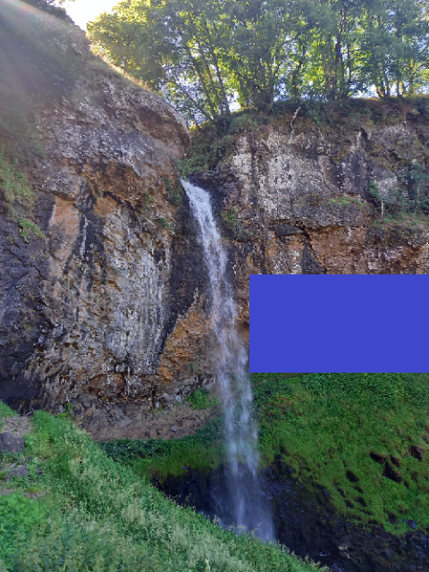
Q4 : Une photo de vous sur le site est optionnelle mais sympathique.

 EARTHCACHE ONLY AT LOW TIDE
Earthcache, no boxes to find
A cascade (or waterfall) is an aerial flow of water either vertical or abrupt along a series of very steep walls, with an often significant drop.
It is most often located in the mountains, where one of the sections of a torrent or even a river, sees its trajectory bed "cut" facing a cliff or a steep rock wall, transforming over this portion into a large waterfall completely vertical or very steep. The fall of water obeys the laws of gravity descending at increasing speed, accompanied by a certain scattering and evaporation of the droplets, as well as a widening of dispersion of the flow (sometimes forming under the sun a rainbow -sky), especially during percussion below, then returning to its regular torrential course.
In the most important cases, it can be a very impressive spectacle where a large flow of several convergent simultaneous falls rushes into the void from the upper "plateau", towards a kind of giant natural "funnel", accompanied by considerable noise and splashes of water or spray at tens or hundreds of meters which can cause a phenomenon of rock erosion.
The water falling by several meters takes speed. When water hits the rock, the mechanical effect breaks up the softest materials and makes the stones shock against each other which force break and wear out, creating a cavity in the rock.
When we consult the geology of the subsoil (source site of the brgm (http://infoterre.brgm.fr/), we see that the subsoil is composed of basaltic rock and that in the underlying layers are composed of marl and oligocene clays:
Basalt is a hard rock composed of plagioclases (about 50%), pyroxenes (20 to 40%), olivine (10 to 25%) and magnetite (2 to 3%)
Marl is a sedimentary rock, a mixture of calcite (CaCO3) and clay in roughly equivalent proportions varying from 35% to 65%. The presence of clay makes the marl softer.
The Salins waterfall is the most famous of the Haute-Auvergne waterfalls. Installed in a case of volcanic rocks and forest, it lets the Auze river escape by a vertiginous water jet of 30m.
The real pleasure consists in passing "on the other side", literally behind the waterfall, inside the space dug in the crevices of the rock. The world seen through water
To validate your visit on the site,
Loguez this hiding place " Found it " and send me the proposals of answers by specifying the name of Earthcache via my profile is via the messaging geoocaching.com and I shall contact you in case of problem
THE LOGS REGISTERED(RECORDED) WITHOUT ANSWERS WILL BE DELETED(ELIMINATED)
Q1: The erosion of the rock was caused by which element? Explain the phenomenon
Q2: By observing the rocks behind the waterfall and the one above, do you consider that they are the same? According to the description and your observations, which rocks is it? Which is the most tender?.
Q3: The erosion has dug a hole (blue square), what is its shape? and its orientation?
Q4: A photo of you on the site is optional but nice.