SLO: Med Vrhniko in Logatcem se proti Zaplani vije najdaljši rimski spomenik v Sloveniji, ki mu domačini pravijo Ajdovski zid. Je del obsežnega poznorimskega obrambno-zapornega sistema, ki so ga Rimljani zgradili med Reko na Hrvaškem in Oglejem v Italiji in se imenuje claustra Alpium Iuliarum. Zgrajen je bil v drugi polovici 3. stoletja, deloval pa je do začetka 5. stoletja. Zaporni sistem je predstavljal dodatno, notranjo mejo rimskega imperija, saj je njegovo osrčje ščitil pred sovražniki z vzhoda ter mu tako zagotavljal stabilnost in blagostanje. Ajdovski zid je dolg okoli 7 km, ob njem pa je nekoč stalo kar 35 obrambnih stolpov. Dva med njimi sta delno rekonstruirana, zato na poti lahko začutiš velikopoteznost rimskih graditeljev.
Ajdovski zid je že dolga stoletja zapuščen. Toda življenje ob njem ni nikoli izginilo. Gozd okrog njega je zanimiva in raznolika pokrajina in je dom številnim rastlinam in živalim, zato vas s tem zakladom vabimo, da si ogledate kako najdaljši rimski spomenik kljubuje zobu časa in kako je življenje nekdaj potekalo ob njem.
Zaklad je večstopenjski in je deloma zasnovan kot uganka. Štampiljke in blazinica naj ostanejo v zakladu! Z iskanjem začnite na podanih koordinatah in samo sledite poti. Vsi odgovori na zastavljena vprašanja po vrsti sledijo poti ob ajdovskem zidu. Vaša naloga je, da dobro opazujete naravo okoli sebe, da odkrijete odgovore na vseh deset vprašanj in na koncu izračunate, kje so rimski vojaki v začetku 5. stoletja, tik preden so zapustili ta prostor, skrili manjši zaklad, v upanju, da se nekoč vrnejo ponj. Za lažje reševanje si pred odhodom od doma natisnite vprašanja.
V kolikor začnete z iskanjem zaklada s parkirišča 3 (P3), potem nalogo rešujete v obratnem vrstnem redu. Odcep z glavne ceste na pot Ajdovski zid je na N 45° 57.042' E 14° 14.131'.
I = Ali je rekonstruiran obrambni stolp pravokotne ali kvadratne oblike? (Pozor: NE hodite po obzidju, da ga ne poškodujete!)
~ pravokotna = 15
~ kvadratna = 10
II = Na informacijski tabli poiščite romantizirano rekonstrukcijo trdnjave Ad Pirum. Katerega leta je nastala grafika? Za končni izračun potrebujete le tretjo števko iz te letnice.
III = Prišli ste do naslednje informacijske table, ki opisuje kraški pojav v bližini. Najdite leseno tablo, ki označuje kraško jamo, rimska številka na njej je?
IV = Na poti se srečate z rimskim vojakom, koliko kosov orožja nosi?
V = Ob klopci, kjer se lahko spočijete po strmem vzponu vas pričaka še en rimski vojak. Preštejte prste na njegovi levi roki?
VI = Pri votlini v katero so se v slabem vremenu lahko zatekli tudi vojaki je lesena tabla s še eno rimsko številko. Katero?
VII = Prišli ste do druge rekonstrukcije obrambnega stolpa, kjer se nahaja tudi daljnogled. Kaj lahko vidite, če pogledate skozenj?
~ Rimski Nauportus z Emono v ozadju = 12
~ Rimski zid = 14
~ Vrhniko z okolico = 21
VIII = Po poti do naslednje in hkrati zadnje informacijske table poiščite leseno tablo z napisom obramba. Rimska številka na njej je?
IX = Koliko oseb lahko preštejete na informacijski tabli "Rimski vojaki v pozni antiki"?
X = Največ koliko kilogramov težko opremo so nosili vojaki?
Tako, preostalo vam je le še računanje lokacije kam so rimski vojaki pred umikom skrili svoj zaklad.
Formula za izračun je:
N45°(III)(II).(IV+V)(IX)(VI)
E014°(VIII+IV).(I*X+VII)
Kontrolna vsota I + II + III + …X = 120
Kdor želi pot »Smaragdna dogodivščina ob ajdovskem zidu« izkusiti še bolj doživljajsko si o dodatnih možnostih, ki jih pot ponuja, lahko prebere na https://visitvrhnika.si/dogodki/smaragdna-dogodivscina-ob-ajdovskem-zidu/ ali na https://www.skrateljc.org/smaragdna-dogodivscina-ob-ajdovskem-zidu/
Nekaj dodatnih razlag čemu je bil obrambni zid claustra Alpium Iuliarum namenjen, kdo in zakaj so ga zgradili, kako je izgledal in koliko časa je bil aktiven si lahko pogledate na spletni strani https://www.youtube.com/watch?v=tFkzNfmUf6o
Vir informacij: zgoraj omenjena spletna stran.
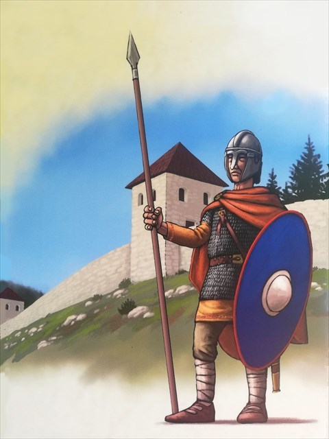 Rimski vojak ob zidu (foto: Emahana, fotografija izvzeta iz info table na poti)
ENG: Between Vrhnika and Logatec, the longest Roman monument in Slovenija leads towards Zaplana, which the locals call the Ajdovski zid (Pagan wall). It is part of an extensive Late Roman defense-barier system built by the Romans between Rijeka in Croatia and Aquileia in Italy and is called claustra Alpium Iuliarum. It was built in the second half of the 3rd century and was in use till the beginning of the 5th century. The barier system represented an additional, internal frontier of the Roman Empire, as it protected its heart from enemies from the east, thus providing it with stability and prosperity. The Ajdovski zid is about 7 km long, and once had as many as 35 defensive towers. Two of them have been partially reconstructed, so along the way you can see the great ambition of the Roman builders.
The Ajdovski zid has been abandoned for many centuries. But life next to it never disappeared. The forest around it is an interesting and diverse landscape and its home to many plants and animals, so with this cache, we invite you to see how the longest Roman monument defies the ravages of time and how life once went along with it.
This cache is actualy multi-level, partly designed as a puzzle. Leave the stamps and pad in the cache! Start the path at the given coordinates and just follow the path. All the answers to the questions asked, follow the path along the Ajdovski zid. Your job is to observe the nature around you, to discover the answers to all ten questions, and finally to calculate where Roman soldiers hid a small treasure in the early 5th century, just before they left this area, hoping to one day they will return for it. To help solve, print out the questions before you leave home.
If you start searching the cache from Parking 3, than you solve the task in the reverse order. The turn off from the main road to the Ajdovski zid path is at point N 45° 57.042' E 14° 14.131'.
I = Is the reconstructed defensive tower rectangular or square in shape? (Caution: DO NOT walk on the wall to avoid damaging it!)
~ rectangular = 15
~ square = 10
II = Look for a romanticized reconstruction of the Ad Pirum fortress on the information board. In what year was the graphic created? You only need the third digit of this year for the final calculation.
III = You have come to the following information board describing a nearby karst phenomenon. Find a wooden sign indicating a karst cave (kraška jama), a Roman numeral on it is?
IV = On the way you meet a Roman soldier, how many pieces of weapons does he carry?
V = At the bench, where you can rest after a steep climb, another Roman soldier is waiting for you. Count the fingers on his left hand?
VI = At the cave (votlina), in which soldiers could also take refuge in bad weather, there is a wooden board with another roman numeral. Which one?
VII = You have come to the second reconstruction of the defensive tower, where the binoculars are also located. What can you see if you look through it?
~ Roman Nauportus and Emona with the background = 12
~ Roman wall = 14
~ Vrhnika with surroundings = 21
VIII = On the way to the next and at the same time the last information board, find a wooden board with the inscription defense (obramba). The Roman numeral on it is?
IX = How many people can you count on the information board "Roman soldiers in late antiquity"?
X = At most, how many kilograms of heavy equipment did the soldiers carry?
So, all you have to do is calculate the location where the Roman soldiers hid their treasure before retreating.
The cache is hidden at:
N45 ° (III) (II). (IV + V) (IX) (VI)
E014 ° (VIII + IV). (I * X + VII)
Checksum: I + II + III +… X = 120
Some additional explanations of what the Claustra Alpium Iuliarum defensive wall was intended for, who and why it was built, what it looked like and how long it was active can be found at https://www.youtube.com/watch?v=tFkzNfmUf6o
Info: https://www.visitvrhnika.si/si/kaj-poceti/1548.