
La Earhcache / The Earhcache
Sur les contreforts du Dévoluy, la Vallée du Grand Buëch, appelée Bochaine, est marquée par sa structure géologique et des paysages modelés par le Grand Buëch.
► Côté géologie, les vestiges d'un océan alpin
Depuis sa source jusqu'à Saint Julien en Beauchêne, le Grand Buëch traverse une grande diversité de formations sédimentaires carbonatées secondaires et tertiaires.
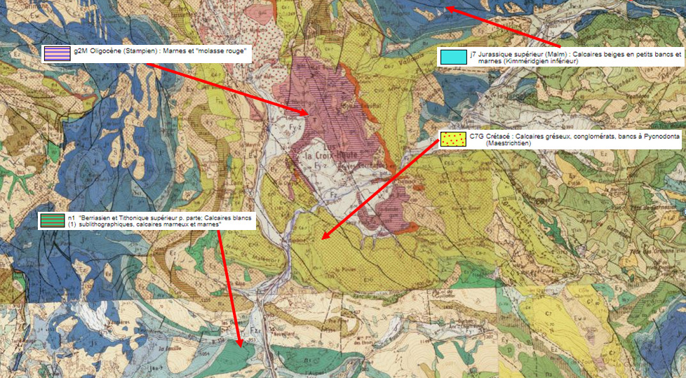
Calcaires de l'Oxfordien ou du Tithonique, Conglomérats du Maestrichien, Calcaires et Marnes du Kimméridgien, toutes ses formations ont en commun d'être des formations sédimentaires issues du dépôt d'éléments (vivants ou minéraux) qui ont été compactés et transformés par diagenèse.
Il existe plusieurs façons de caractériser et différencier ces couches géologiques.
~ Les conditions de formation
- Formation par précipitation chimique, qui donne une roche sédimentaire chimique (pas de fossiles, grains généralement très fins). Ex : la craie.
- Formation par précipitation chimique et restes d'organismes vivants en quantité importante,qui donne une roche sédimentaire biogénique. Ex : nombreuses calcaires : Echaillon, Urgonien,...
- Formation par dépôt de débris d'une roche antérieure donnant une roche sédimentaire détritique. Ex : Grès, Conglomérats.
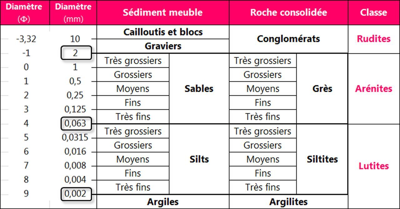
~ La taille des éléments
Dans le cas d'une roche détritique, il est possible de la classer selon la taille des débris :
Les Siltites, ou Marnes, sont des roches d'origine argileuse, tendres et lisses au toucher.
Les Grès (quartziques ou calcaires) sont granuleux au toucher.
Les conglomérats sont formées par un minimum de 50 % de clastes de dimension supérieure à 2 mm liés par un ciment. On distingue :
- les brèches composées de blocs anguleux dont les clastes sont souvent d'origine glaciaire.
- les poudingues composés de galets aux formes arrondies déposés par un cours d'eau.

► Une vallée sculptée par les forces de la nature
Les horizons des vallées des Buëch annoncent la fin de la Provence et l’amorce du pays haut alpin.
Les roches dures des calcaires associées aux roches tendres des marnes créent ses paysages où les pentes adoucies des versants sont interrompus par des formes hérissées d'échines rocheuses.
Les formations sédimentaires mises en place dans l'océan alpin ont été brutalement ramenées à la surface lors de l'orogenèse alpine. Ces couches horizontales ont été plissées et fracturées.
Se sont ainsi mis en place une succession d'anticlinaux et de synclinaux qui racontent le travail de plissements et de chevauchements de la formation des Alpes.
- Synclinal : Lorsque des couches sédimentaires de roches forment des plis, la partie d'une couche plissée qui forme un creux se nomme Synclinal. La couche la plus récente est à l'intérieur du pli.
- Anticlinal : Lorsque des couches sédimentaires de roches forment des plis, la partie d'une couche plissée qui forme une bosse se nomme Anticlinal. La couche la plus récente est à l'extérieur du pli.

► Côté hydrologie, le territoire du Grand Buëch
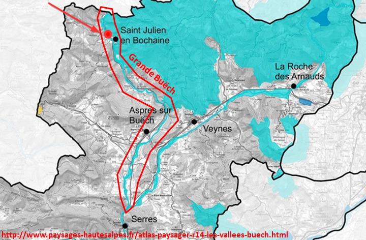
Le Grand Buëch prend sa source à plus de 2000 mètres d'altitude au coeur du vallon de Jarjatte et rejoint après un parcours tumultueux de 40 km la Petite Buëch en amont de Serres.
Ce bassin supérieur du Buëch est appelé le pays de Bochaine.
C'est une rivière abondante, alimentée par des précipitations abondantes et la partie montagneuse longuement enneigée de son bassin.
La lame d'eau écoulée dans son bassin versant est de 576 millimètres annuellement, très largement supérieur à la totalité du bassin de la Durance.
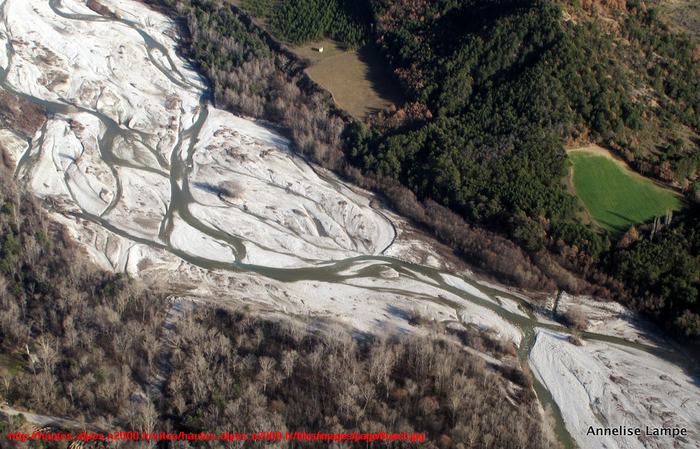
Caractéristique des Alpes du Sud, cette rivière torrentielle transporte d'importantes quantités de galets issus de l'érosion du massif calcaire du Dévoluy.
Ces sédiments fluviaux forment des bancs ou isles autour desquels s'écoulent des chenaux redessinés au fil des crues ; cela donne un fonctionnement en tresses, rare dans les rivières françaises.
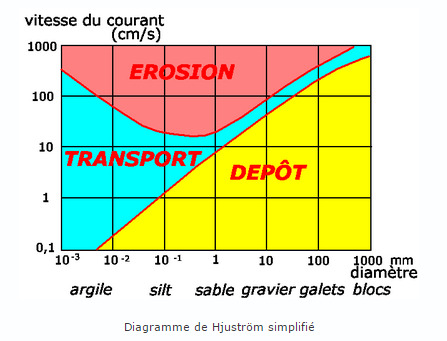
Il est possible de déterminer les conditions du courant en fonction de la taille des sédiments présents dans les lits majeurs et mineurs en utilisant le diagramme de Hjuström :
In the foothills of Dévoluy, the Grand Buëch Valley, called Bochaine, is marked by its geological structure and landscapes shaped by the Grand Buëch.
► In terms of geology, the remains of an Alpine ocean
From its source to Saint Julien en Beauchêne, the Grand Buëch crosses a great diversity of secondary and tertiary carbonate sedimentary formations.
Limestones from the Oxfordian or Tithonic, Conglomerate from the Maestrichian, Limestone and Marl from the Kimmeridgian, all of its formations have in common that they are sedimentary formations resulting from the deposit of elements (living or mineral) which have been compacted and transformed by diagenesis.
There are several ways to characterize and differentiate these geological layers.
~ Formation conditions
- Formation by chemical precipitation, which gives a chemical sedimentary rock (no fossils, generally very fine grains). Ex: chalk.
- Formation by chemical precipitation and remains of living organisms in significant quantity, which gives a biogenic sedimentary rock. Ex: many limestones: Echaillon, Urgonien, ...
- Formation by deposit of debris from an anterior rock giving a detrital sedimentary rock. Ex: Sandstone, Conglomerate.
~ The size of the elements
In the case of a detrital rock, it is possible to classify it according to the size of the debris:
Marnes are rocks of clay origin, tender and smooth to the touch.
Sandstones (quartz or limestone) are grainy to the touch.
The conglomerates are formed by a minimum of 50% of clasts larger than 2 mm bound by a cement. We distinguish :
- the breccias composed of angular blocks whose clasts are often of glacial origin.
- pudding made up of pebbles with rounded shapes deposited by a stream.
► A valley sculpted by the forces of nature
The horizons of the Buëch valleys herald the end of Provence and the beginning of the high Alpine country.
The hard limestone rocks associated with the soft marl rocks create its landscapes where the softened slopes of the slopes are interrupted by forms bristling with rocky spines.
The sedimentary formations set up in the Alpine Ocean were brutally brought to the surface during the Alpine orogeny. These horizontal layers were folded and fractured.
A series of anticlines and synclines have thus been set up which recounts the work of folding and overlapping of the formation of the Alps.
- Synclinal: When sedimentary layers of rock form folds, the part of a pleated layer which forms a hollow is called Synclinal. The most recent layer is inside the fold.
- Anticline: When sedimentary layers of rock form folds, the part of a pleated layer that forms a bump is called Anticline. The most recent layer is on the outside of the fold.
► On the hydrological side, the territory of Grand Buëch
The Grand Buëch rises at an altitude of over 2000 meters in the heart of the Jarjatte valley and joins after a tumultuous 40 km course the Petite Buëch upstream of Serres.
This upper Buëch basin is called the Bochaine country.
It is an abundant river, fed by abundant precipitation and the mountainous part snow-covered for a long time of its basin.
The sheet of water flowing in its watershed is 576 millimeters annually, very much greater than the whole of the Durance basin.
Characteristic of the Southern Alps, this torrential river transports large quantities of pebbles from the erosion of the Dévoluy limestone massif.
These fluvial sediments form banks or isles around which flow channels redrawn over the floods; this gives an operation in braids, rare in French rivers.
It is possible to determine the current conditions according to the size of the sediments present in the major and minor beds using the Hjuström diagram:
► Sources bibliographiques / Bibliographical sources
Les Questions / The Questions
Questions pour valider :"Vallée du Bochaine et Grand Buëch"
Questions to validate: "Bochaine Valley and Grand Buëch"
!!! Ne pas allez au WP1 en cas de crues du Grand Buëch !!!
!!! Do not go to WP1 in case of flooding of the Grand Buëch !!!
- Question 0 : Prenez une photo de vous ou d'un élément vous identifiant avec le Grand Buëch en arrière plan.
Cette photo devra au choix nous être transmise avec les réponses ou être ajoutée à votre log.
-Question 0 : - Question 0: Take a picture of yourself or something identifying you with the Grand Buëch in the background.
This photo must either be sent to us with the answers or added to your log.
Point 1 : N 44° 37.137 E 005° 42.150
Vous voici dans le lit majeur de la rivière (ne pas y aller en périodes de crues !).
Here you are in the major river bed (do not go there during floods!).
- Question 1 : Décrivez le lit majeur (structure, largeur, végétaux) ; au milieu de quelle structure du Grand Buëch vous trouvez-vous ?
- Question 1: Describe the major bed (structure, width, plants); in the middle of which structure of the Grand Buëch are you?
- Question 2 : Quelle forme et quelle taille ont les plus gros blocs du lit ? En fonction de ces éléments, déterminez la vitesse maximale du Haut Buëch et son régime.
- Question 2: What shape and size are the largest blocks in the bed? Based on these elements, determine the maximum speed of the Haut Buëch and its speed.
Point 2 : N 44° 37.153 E 005° 42.162
Vous voici devant un panneau présentant la vallée du Grand Buëch.
Here you are in front of a sign presenting the Grand Buëch valley.
- Question 3 : Un pli est visible sur une photo du panneau ; caractérisez le en expliquant la raison de votre choix.
- Question 3: A fold is visible on a photo of the panel; characterize it by explaining the reason of your choice.
Point 3 : N 44° 37.147 E 005° 42.127
Juste derrière un panneau sur le Grand Buëch, dirigez vous vers le bord du lit de la rivière. Vous pouvez voir des gros blocs formant une digue protectrice (WP3).
Just behind a sign on the Grand Buëch, head towards the edge of the river bed. You can see large blocks forming a protective dike (WP3).
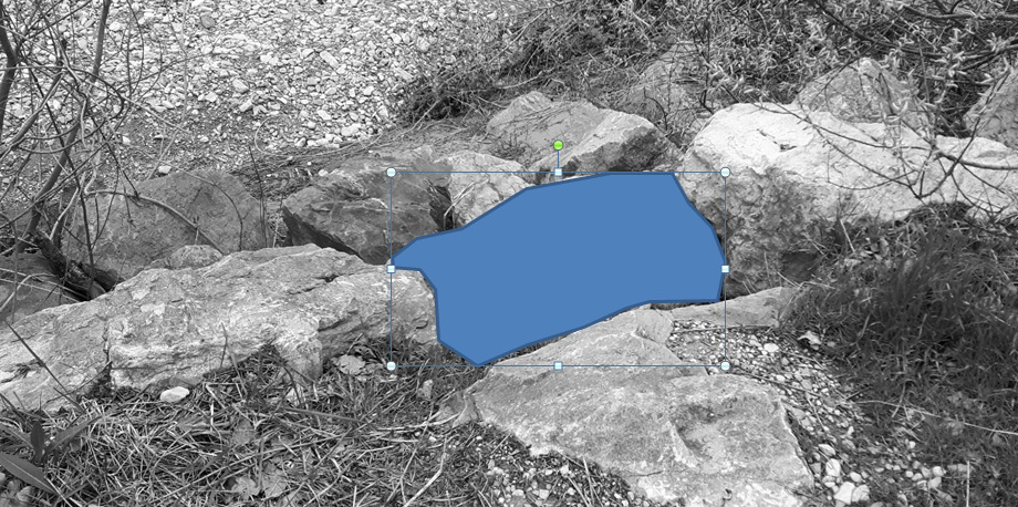
- Question 4 : Décrire le bloc de roche sous la zone bleue. Quelles sont les conditions de formation de cette roche et sa famille ? En fonction de la taille de ces éléments, caractérisez la roche.
- Question 4 : Describe the block of rock under the blue area. What are the conditions for the formation of this rock and its family? Depending on the size of these elements, characterize the rock.
Vous pouvez vous loguer sans attendre notre confirmation,
mais vous devez nous envoyer les réponses par mail en même temps via notre profil (
fafahakkai).
S'il y a des problèmes avec vos réponses nous vous en ferons part.
Les logs enregistrés sans réponses seront supprimés.Une photo de vous ou de votre GPS à un des WPs (mais sans prendre en photo le panneau ou les spots d'observation) serait la bienvenue, mais n'est pas obligatoire
You can log this cache without waiting for our confirmation, but you must send us the answers by e-mail at the same time via our profile (fafahakkai).
If there is a problem with your answers we will notify you. The logs recorded without answers will be deleted.
A picture of you or your GPS to a WPs (but not to photograph the sign or observation spots) would be welcome but is not mandatory.
Rappel concernant les « Earthcaches »: Il n'y a pas de conteneur à rechercher ni de logbook à renseigner. Il suffit de se rendre sur les lieux, de répondre aux questions ci-dessus et de nous renvoyer les réponses.
Reminder concerning "Earthcaches": there is neither a container to look for nor a logbook to sign. One need only go to the location, answer to the differents quiestions and send us the answers.