
La Earhcache / The Earhcache
► Contexte géologique local
Saint-Jean-des-Vignes est une commune du pays des Pierres Dorées, région caractérisée par une succession de formations du Jurassique entaillées lors de l'orogenèse alpine.
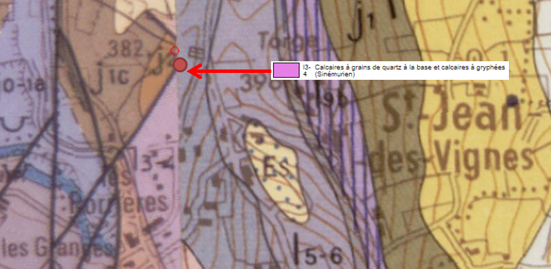
Au lieu dit de la Pierre Folle, plusieurs de ces formations sédimentaires sont mises au contact.
Une roche sédimentaire se forme à température et pression ambiante et provient de diverses particules transportées puis déposées au fond de lacs, mers ou océans avant de se consolider.
Il est possible de les caractériser selon leur processus de formation :
- Formation par précipitation chimique donnant une roche sans fossile, à grains très fins (ex : Craie).
- Formation par dépôts de restes d'organismes vivants : roche biogénique (ex : Oolithiques).
- Formation par dépôts de débris terrigènes : roche détritique (ex : Grès).

► Le calcaire à Gryphées
~ Formation
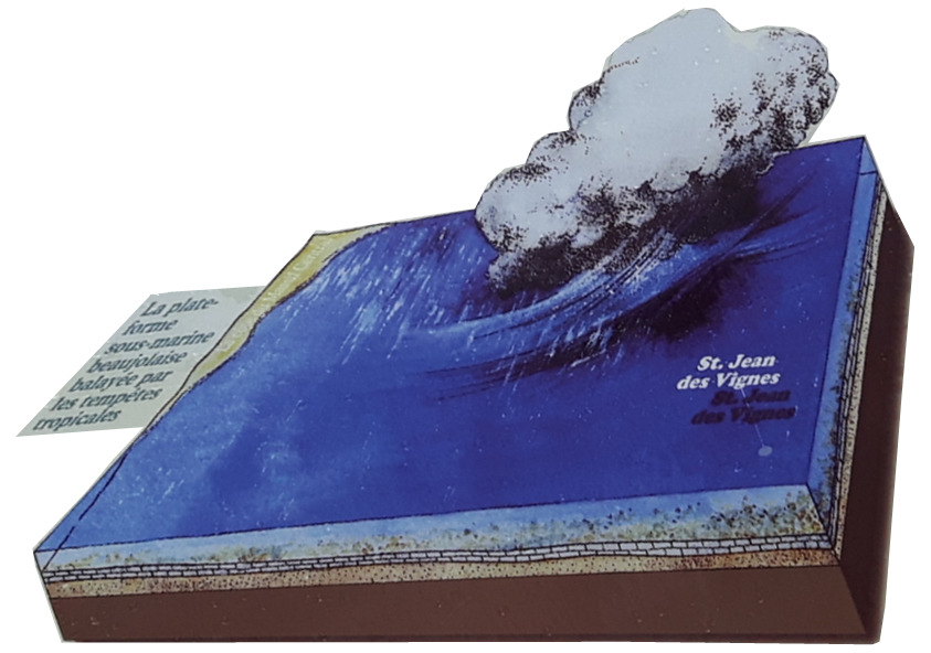
Il y a 195 millions d'années, au Sinémurien, la région de Saint Jean des Vignes est soumise à un épisode de transgression marine d'importance aboutissant à un mer peu profonde.
Sur cette plateforme continentale s'installe une zone d'herbiers avec une riche faune marine (huîtres, gryphées, moules de grandes tailles (plagiostromes), ammonites, bélemnites,...).
~ Caractéristiques
Le calcaire à Gryphées est une formation biomicritique gris-bleu ou roussâtre en bancs irréguliers peu épais, très bioturbés, à surface bosselée et séparés par de minces interlits marneux.
Ces surfaces bosselées, particulièrement visibles en falaises naturelles ou sur fronts de tailles des carrières, peuvent avoir trois origines :
- des figures de ravinement par des courants marins ou lors de tempêtes
- des figures de bioturbation (traces de reptation ou d'enfouissement des animaux)
- une intense stylolitisation (les joints stylolitiques augmentant et exagérant les ondulations dues aux deux précédentes origines).

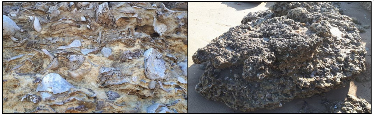
Ce calcaire comprend des bancs qui sont de véritables lumachelles de Gryphea arcuata.
Les lumachelles sont des strates bioclastiques très fossilifères faites d'organismes marins à la coquille résistante dans une matrice calcaire indurée.
~ Fossiles sinémuriens et stratigraphie
Dominée par les gryphées, la faune fossile de calcaire indique un paléoenvironnement de vasière marine en bordure des terres émergées du continent armoricain.
Cette environnement à la faune très riche permet de retrouver de nombreux fossiles.
À côté des Gryphées, on peut recueillir des lamellibranches, gastéropodes, brachiopodes, articles de crinoïdes, bélemnites, ammonites...

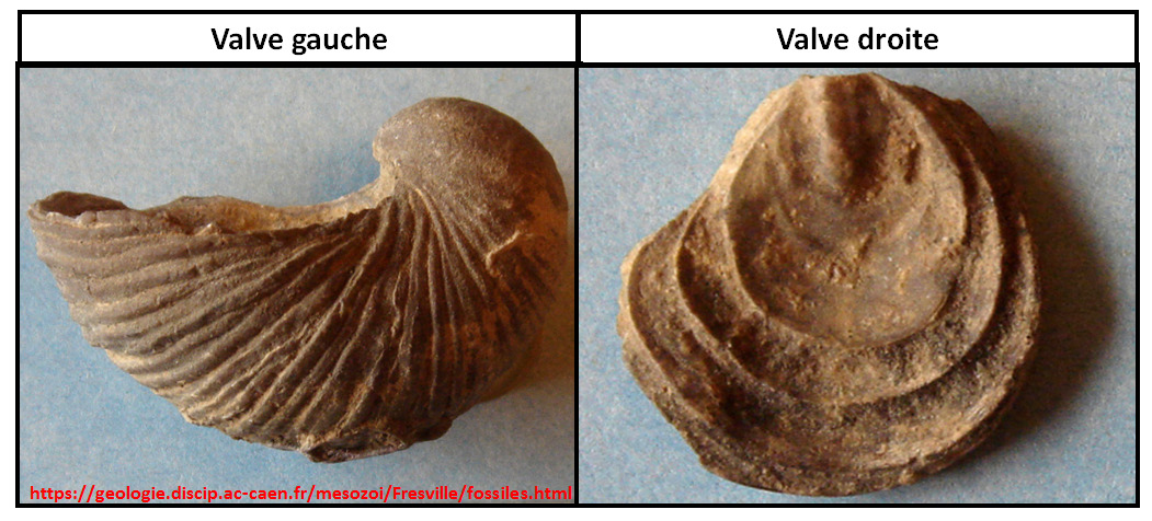
Très répandus dans les mers de toute l’Europe occidentale au Sinémurien, les gryphées (Gryphaea arcuata) sont des bivalves particuliers caractérisés par une coquille inéquivalve asymétrique :
- la valve gauche très bombée est courbée en crochet ou griffe.
- la valve droite est plate et petite en forme d'opercule.
Cette espèce, présente uniquement au Sinémurien, joue le rôle de fossile stratigraphique (fossile dont la présence permet de réaliser la datation absolue d'une roche).
► Local geological context
Saint-Jean-des-Vignes is a commune in the Pierres Dorées region, a region characterized by a succession of Jurassic formations cut during the Alpine orogeny.
At a place called Pierre Folle, several of these sedimentary formations are brought into contact.
A sedimentary rock is formed at room temperature and pressure and comes from various particles transported and then deposited at the bottom of lakes, seas or oceans before consolidating.
It is possible to characterize them according to their formation process:
- Formation by chemical precipitation giving a rock without fossil, with very fine grains (ex: Chalk).
- Formation by deposits of remains of living organisms: biogenic rock (ex: Oolithics).
- Formation by deposits of terrigenous debris: detrital rock (ex: Sandstone).
► Limestone at Gryphées
~ Formation
195 million years ago, in the Sinemurian, the region of Saint Jean des Vignes was subjected to an episode of major marine transgression leading to a shallow sea.
On this continental platform, there is a zone of seagrass beds with a rich marine fauna (oysters, grypheus, large mussels (plagiostromes), ammonites, belemnites, ...).
~ Features
The Grypheus limestone is a gray-blue or reddish biomicritic formation in irregular thin banks, very bioturbated, with bumpy surface and separated by thin marly interlits.
These bumpy surfaces, particularly visible in natural cliffs or on quarry faces, can have three origins:
- figures of gullying by sea currents or during storms
- bioturbation figures (traces of crawling or burial of animals)
- intense stylolitization (stylolitic joints increasing and exaggerating the undulations due to the two previous origins).
This limestone includes benches which are true lumachelles of Gryphea arcuata.
The lumachelles are very fossiliferous bioclastic strata made of marine organisms with a resistant shell in an indurated calcareous matrix.
~ Sinemurian fossils and stratigraphy
Dominated by the gryphées, the fossil limestone fauna indicates a paleoenvironment of marine mud on the edge of the land of the Armorican continent.
This environment with very rich fauna allows to find many fossils.
Next to the Gryphées, one can collect lamellibranchs, gastropods, brachiopods, articles of crinoids, belemnites, ammonites ...
Very widespread in the seas of all Western Europe in Sinemurian, the gryphées (Gryphaea arcuata) are particular bivalves characterized by an asymmetrical unequal shell:
- the very domed left valve is curved in a hook or claw.
- the right valve is flat and small in the form of a seal.
This species, present only in the Sinemurian, plays the role of stratigraphic fossil (fossil whose presence allows the absolute dating of a rock).
► Sources bibliographiques / Bibliographical sources
Les Questions / The Questions
Questions pour valider :"Calcaire à Gryphées à Saint Jean des Vignes"
Questions to validate: "Limestone with gryphées in Saint Jean des Vignes"
- Question 0 : Prenez une photo de vous ou d'un élément vous identifiant sur le site, mais pas au WPs.
Cette photo devra au choix nous être transmise avec les réponses ou être ajoutée à votre log.
-Question 0 : - Take a photo of yourself or an identifying item on the site, but not at the WPs.
This photo must either be sent to us with the answers or added to your log.
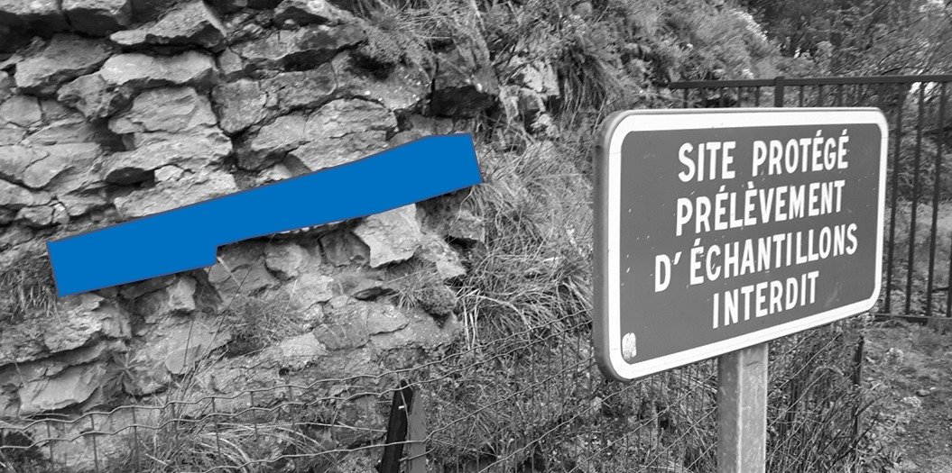
Point 1 : N 45° 52.731 E 004° 40.592
Vous voici juste avant l'entrée du site des Pierres Folles (photo WP1).
Here you are just before the entrance to the Pierres Folles site (photo WP1).
- Question 1 : Décrivez la roche (taille des grains, couleur, litage, fossiles). Comment pouvez qualifier cette roche par rapport à ses conditions de formation ?
- Question 1: Describe the rock (grain size, color, bedding, fossils). How can this rock be qualified in relation to its training conditions?
- Question 2 : Que voyez-vous en nombre sous la zone bleue ? Au vue de ce nombre, comment pouvez-vous qualifier cette strate précise de l'affleurement ?
- Question 2: What do you see under the blue area? In view of their number, how can you qualify this stratum of outcrop?
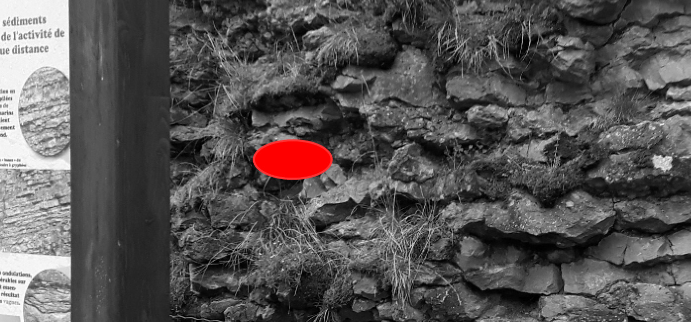
Point 2 : N 45° 52.734 E 004° 40.596
Décalez vous de quelques mètres jusqu'à un panneau se trouvant juste devant un vaste affleurement.
Shift a few meters to a sign just in front of a large outcrop.
- Question 3 : Quelles formes prennent les strates de l'affleurement ? Émettez des hypothèses sur l'origine de cette disposition.
- Question 3: What forms do the strata of outcrop take? Make assumptions about the origin of this provision.
- Question 4 : D'après le panneau, quelles étaient les conditions météorologiques au Sinémurien (-195 Ma) ? Cela est-il cohérent avec vos observations et hypothèses de la question 3 ?
- Question 4: According to the panel, what were the weather conditions at Sinémurien (-195 Ma)? Is this consistent with your observations and assumptions in question 3?
- Question 5 : Que voyez-vous sous la zone rouge ? Pouvez qualifier ces éléments de stratigraphiques ?
- Question 5 : What do you see under the red zone? Can you describe these elements as stratigraphic?
Vous pouvez vous loguer sans attendre notre confirmation,
mais vous devez nous envoyer les réponses par mail en même temps via notre profil (
fafahakkai).
S'il y a des problèmes avec vos réponses nous vous en ferons part.
Les logs enregistrés sans réponses seront supprimés.You can log this cache without waiting for our confirmation, but you must send us the answers by e-mail at the same time via our profile (fafahakkai).
If there is a problem with your answers we will notify you. The logs recorded without answers will be deleted.
Rappel concernant les « Earthcaches »: Il n'y a pas de conteneur à rechercher ni de logbook à renseigner. Il suffit de se rendre sur les lieux, de répondre aux questions ci-dessus et de nous renvoyer les réponses.
Reminder concerning "Earthcaches": there is neither a container to look for nor a logbook to sign. One need only go to the location, answer to the differents quiestions and send us the answers.