La rivière de Rançon traversent le village avant de se jeter dans la Seine.
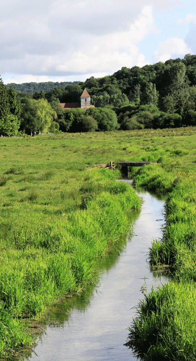
Le réseau hydrographique du territoire du SMBV Caux Seine représente environ 17 km de rivières avec 4 cours d’eau principaux (la Rançon, la Fontenelle, la Sainte Gertrude et l’Ambion) et leurs affluents (le Perroy, le Brébec, la Neuville et la Minérale). 3 des principaux cours d’eau (La Rançon, la Sainte Gertrude et l’Ambion) sont affluents de la Seine au niveau de la communes de Rives en Seine (Saint Wandrille Rançon et Caudebec en Caux).
Ces cours d’eau drainent des bassins versants essentiellement agricole sur une surface totale de 173.86 km ² où se trouve deux agglomérations principales : Yvetot et Rives en Seine.
Ces rivières issues de la nappe de la craie sont soutenues toute l’année avec des débits relativement stables et offre des eaux limpides et de bonnes qualités dans l’ensemble.
Linéaire : 4000 ml
Débit : 2.4m3/s
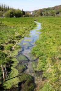
Les zones humides sur notre territoire:
Les zones humides de nos vallées sont des annexes hydrauliques des cours d’eau en constante communication aussi bien d’un point de vue hydraulique que hydro-écologique. Elles ont un rôle important dans la protection des biens et des personnes car elles peuvent absorber les crues de nos rivières, en offrant de vastes espaces où les eaux peuvent y être stockées. D’un point de vue hydraulique nous les appelons : zones d’expansions des crues. Ces zones sont en général situées dans le lit majeur des rivières.
Les zones humides possèdent également un rôle écologique avec la présence d’une biodiversité remarquable mais extrêment fragile (présence de plantes et d’animaux protégés aux niveaux régional et national).

Concernant la earthcache:
Vous vous trouvez devant la source de la Rançon.
Loguez cette cache "Found it" et envoyez-moi vos propositions de réponses soit via mon profil, soit via la messagerie geocaching.com (Message Center), et je vous contacterai en cas de problème.
1) D'où provient l'eau de la source? Comment arrive-elle içi?
2) Sommes-nous en présence d'une fontaine ou d'une source? Expliquez votre réponse.
3) Plus loin le cours d'eau descend vers la Seine. Par quelle étendue passe-t-il et a quoi sert-elle?
4) Au Wp, pour prouver votre présence, dire où apparait la source.
Une photo serait également grandement appréciée. 
-----------------------------------------------


Definition:
A source in hydrology is the place where liquid water naturally comes out of the ground. A source is very often the source of a stream, a stream, a river or even a river. But a spring can also be submerged in a flow of water, a pond, a lacou a sea.
A fountain is a source where water gushes, sometimes strongly and often architectured
The Valley of the Rançon:

The Rançon Valley is a quiet place to explore with its wet meadows and green hills crowned by the Trait-Maulévrier state forest. The houses took refuge at the foot of the hills, sheltered from flooding. Under the impetus of the Abbey of Fontenelle then the use of hydraulic energy, the valley was endowed with a prosperous agriculture and a dynamic pre-industry: orchards, vineyards, woods, lime kiln... and up to 13 mills. Today, it is a site of great heritage, especially in its downstream part managed by the Camargue horses and the Scottish cattle of the Park.
The Rançon:
The river Rançon crosses the village before jumping into the Seine.
The hydrographic network of the territory of the SMBV Caux Seine represents about 17 km of rivers with 4 main rivers (the Rançon, the Fontenelle, the Sainte Gertrude and the Ambion) and their tributaries (the Perroy, the Brébec, the Neuville and the Mineral). 3 of the main rivers (La Rançon, Sainte Gertrude and Ambion) are tributaries of the Seine at the level of the communes of Rives en Seine (Saint Wandrille Rançon and Caudebec en Caux).
These rivers drain mainly agricultural watersheds on a total area of 173.86 km ² where are located two main agglomerations: Yvetot and Rives en Seine.
These rivers from the chalk table are supported all year round with relatively stable flows and offer clear waters and good qualities overall.
Linear: 4000 ml
Flow rate: 2.4m3/s
Wetlands in our territory:
The wetlands of our valleys are hydraulic annexes of the rivers in constant communication from both a hydraulic and hydro-ecological point of view. They have an important role to play in protecting property and people because they can absorb the flooding of our rivers by providing vast areas where water can be stored. From a hydraulic point of view we call them: zones of flood expansions. These zones are usually located in the major river bed.
Wetlands also have an ecological role with the presence of remarkable but extremely fragile biodiversity (presence of protected plants and animals at regional and national levels).
Concerning the earthcache:
You stand before the source of the Ransom.
Log this "Found it" cache and send me your response proposals either via my profile or via the geocaching.com (Message Center) email, and I will contact you in case of a problem.
1) Where does the source water come from? How does it arrive?
2) Is there a fountain or source? Explain your answer.
3) Further on, the stream descends towards the Seine. What extent does it pass through and what is its use?
4) At Wp, to prove your presence, say where the source appears.
A photo would also be greatly appreciated. 