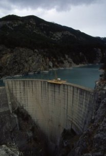
 Le barrage de Pont Baldy, d'une longueur de 91.5 mètres et haut de 56 mètres, est un barrage hydraulique du Département des Hautes-Alpes situé sur le territoire de la commune de Briançon.
Le barrage de Pont Baldy a été construit en 1966 en travers de la rivière Cerveyrette retient un volume d'eau de 958 milliers de m³ sur une surface de 5.10 hectares.
Le barrage de Pont Baldy, de type Voûte, à pour usage principale : Hydroélectricité.
The Baldy Bridge Dam, 91.5 metres long and 56 metres high, is a hydraulic dam in the Department of the Hautes-Alpes located in the territory of the municipality of Briançon.
The Baldy Bridge Dam was built in 1966 across the Cerveyrette River retains a volume of water of 958 thousand m3 on an area of 5.10 hectares.
The Baldy Bridge Dam, type Vault, for main use: Hydroelectricity.
Pour acceder au barrage traverser le pont et suivé le chemin sur votre gauche .
To access the dam cross the bridge and followed the path on your left.