La Earhcache / The Earhcache
► Contexte géologique global
La zone nord de Brétignolles sur Mer présente une vaste formation métamorphique, la métarhyolite porphyroïde de la Sauzaie.
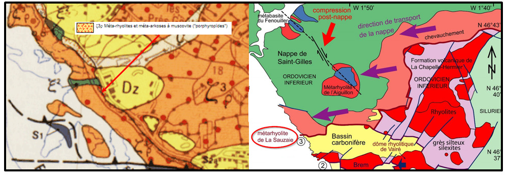
Cette nappe des porphyroïdes de la Sauzaie s’étend, par grands plis successifs, de Brétignolles jusqu’à Saint- Michel-Chef-Chef et Piriac en Loire-Atlantique.
Elle est le fruit d'une vaste nappe de charriage venant du bassin de La Roche sur Yon dont les forces à l'origine de ces déplacements ont fortement remanié un protolithe volcanique.
► La Rhyolite, un protolithe volcanique
La formation initiale dont est issue l'unité de la Sauzaie est une vaste pile volcanique de plus de 1000 mètres de profondeur basée vers l'emplacement de La Roche sur Yon.
Ces formations volcaniques se sont mises en place à l’Ordovicien inférieur, il y a 480 Ma, au niveau d'une zone de subduction.
Les rhyolites marquent une phase très précoce d’une ouverture intra-continentale. Elles résultent d’une fusion de l’écorce due au flux de chaleur qui se dégage de la montée du manteau.
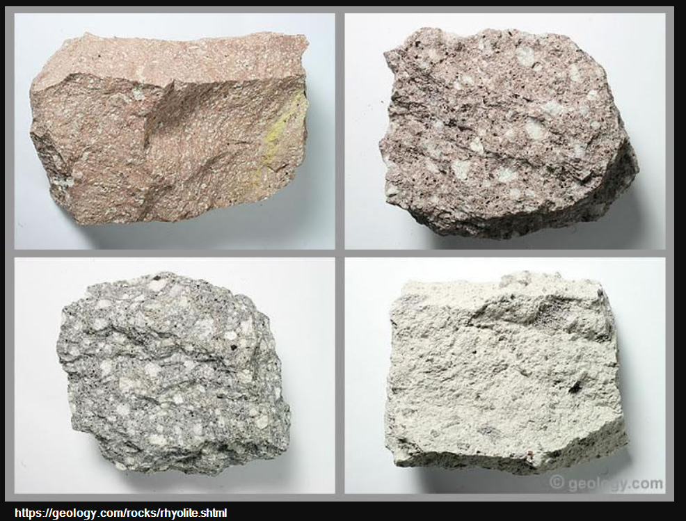
La rhyolite est l'équivalent volcanique du granite. C'est donc une roche riche en silice, dure et à l'origine assez peu grenue, même si elle peut présenter des phénocristaux de quartz ou de feldspaths qui sont disposés aléatoirement dans une pâte plus ou moins bulleuse.
C'est une formation de couleur assez claire, rosée ou grise et parfois bleue.
► Nappe de charriage et Métamorphisme
L'orogenèse hercynienne (mise en place de la chaîne de montagne hercynienne) il y a 400 Ma a complètement bouleversé cette paisible formation volcano-sédimentaire.
La collision des masses continentales a conduit à la mise en place d'une nappe de charriage, un ensemble de couches géologiques décollées du socle et déplacées sur de grandes distances.
Dans le cadre des rhyolites, le déplacement s'est fait sur plus de 60 km vers l'Ouest.
De ce fait la roche a été transformée, métamorphisée pour devenir de la métarhyolite :
- Durcissement et recristallisation des minéraux de la pâte vitreuse.
- Orientation, déformation et allongement des phénocristaux de quartz et de feldspath.
- Déformation de la roche qui devient très fortement aplatie, broyée et étirée.
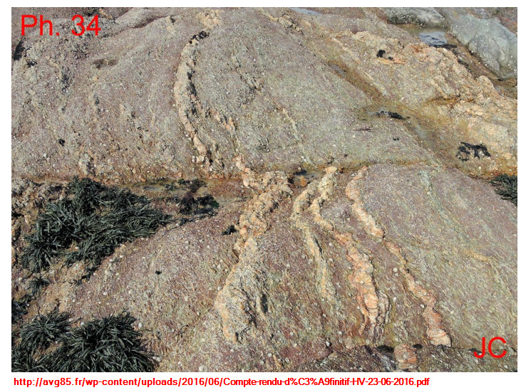
La roche a été littéralement écrasée et montre une intense schistosité par aplatissement.
La direction de transport liée à cet étirement, orientée Nord 260°, s'accompagne de la mise en place d'une semelle mylonitique et d'un écaillage tectonique intense.
Plusieurs zones peuvent se distinguer :
- Des zones mylonitiques : la mylonitisation est la réduction de la taille des grains, donnant une stratification fine, une roche dure et très déformée avec de nombreux plis.
La texture devient fine et la teinte s’assombrit en brun vert.

- Des zones à porphyroclastes : elles ont conservées des mégaphénocristaux de feldspath et de quartz fracturés (grains ovoïdes gris translucides). Ces phénocristaux sont pluricentimétriques, donnant une texture porphyroïde à la roche.
A l'affleurement, les phénocristaux de feldspath potassiques ont souvent disparu par altération, entraînant une surface bosselée avec les phénocristaux de quartz restants.
La rhyolite (et donc la métarhyolite) a une teneur variable en fer. Son altération à l'air libre peut entraîner une coloration marquée de jaune à rouge selon sa teneur en fer et son degré d'oxydation.

Cette formation est injectés par de filons de pegmatite (jus de silice fondu puis recristallisé en quartz) très comprimés et replissés ce qui montre que la base de la formation a subi l’influence d’une granitisation avant d’être décollée.
► Global geological context
The northern area of Brétignolles sur Mer presents a vast metamorphic formation, the porphyroid metarhyolite of the Sauzaie.
This layer of porphyroids from Sauzaie extends, in large successive folds, from Brétignolles to Saint-Michel-Chef-Chef and Piriac in Loire-Atlantique.
It is the result of a large bed of cartloads coming from the La Roche sur Yon basin, the forces behind which these movements have strongly modified a volcanic protolith.
► Rhyolite, a volcanic protolithe
The initial formation from which the Sauzaie unit is derived is a vast volcanic pile over 1,000 meters deep based around the location of La Roche sur Yon.
These volcanic formations were established in the lower Ordovician, 480 Ma ago, at the level of a subduction zone.
The rhyolites mark a very early phase of an intra-continental opening. They result from a fusion of the bark due to the flow of heat from the rise of the mantle.
Rhyolite is the volcanic equivalent of granite. It is therefore a rock rich in silica, hard and originally not very grainy, even if it can present phenocrysts of quartz or feldspar which are arranged randomly in a more or less bubbly paste.
It is a fairly clear, pink or gray and sometimes blue color formation.
► Carriage tablecloth and Metamorphism
The Hercynian orogeny (establishment of the Hercynian mountain range) 400 Ma ago completely upset this peaceful volcano-sedimentary formation.
The collision of land masses led to the establishment of a bed of water, a set of geological layers detached from the base and displaced over great distances.
Within the framework of the rhyolites, the displacement was made on more than 60 km towards the West.
As a result the rock has been transformed, metamorphosed to become metarhyolite:
- Hardening and recrystallization of the minerals in the glassy paste.
- Orientation, deformation and elongation of quartz and feldspar phenocrysts.
- Deformation of the rock which becomes very strongly flattened, crushed and stretched.
The rock has been literally crushed and shows intense flattening schistosity.
The direction of transport linked to this stretch, oriented North 260 °, is accompanied by the establishment of a mylonitic sole and intense tectonic spalling.
Several areas can be distinguished:
- Mylonitic zones: mylonitization is the reduction of the size of the grains, giving a fine stratification, a hard and very deformed rock with many folds.
The texture becomes fine and the shade darkens to greenish brown.
- Zones with porphyroclasts: they have preserved mega-crystals of feldspar and fractured quartz (translucent gray ovoid grains). These phenocrysts are pluricentimetric, giving a porphyroid texture to the rock.
When exposed, the potassium feldspar phenocrysts often disappeared by weathering, resulting in a bumpy surface with the remaining quartz phenocrysts.
Rhyolite (and therefore metarhyolite) has a variable iron content. Its alteration in the open air can cause a marked coloring from yellow to red depending on its iron content and its degree of oxidation.
This formation is injected by pegmatite veins (molten silica juice then recrystallized from quartz) very compressed and folded, which shows that the base of the formation underwent the influence of granitization before being peeled off.
► Sources bibliographiques / Bibliographical sources
Les Questions / The Questions
Questions pour valider :"Nappe de charriage et Métaryolithes à la Sauzaie"
Questions to validate: "Carriage tablecloth and Metaryoliths at Sauzaie"
!!! ATTENTION A LA MAREE !!!
!!! WARNING TO THE TIDE !!!
Avant de vous y aventurer, consulter l'horaire des marées :
Before you go, check the tide schedule:
Horaires des marées pour Bretignolles-sur-Mer.
Point 1 : N 46° 38.109 W 001° 53.432
- Question 0 : Prenez une photo de vous ou d'un élément vous identifiant avec l'estran de la Sauzaie en arrière plan (mais pas les WPs).
Cette photo devra au choix nous être transmise avec les réponses ou être ajoutée à votre log.
-Question 0 : - Question 0: Take a photo of yourself or an item identifying yourself with the Sauzaie foreshore in the background (but not the WPs).
This photo must either be sent to us with the answers or added to your log.
Depuis la base du chemin descendez sur le plateau rocheux juste en dessous (photo WP1).
From the base of the path descend to the rocky plateau just below (photo WP1).
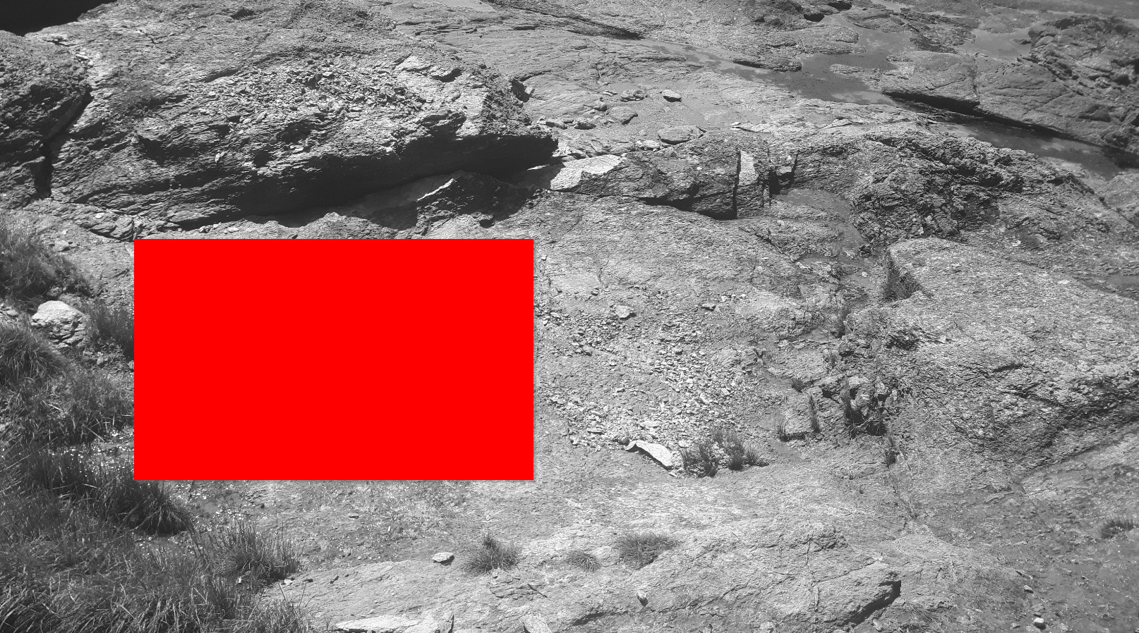
- Question 1 : Quelles sont les couleurs qui se démarquent sur ce plateau (zone rouge) ? Quelle est l'origine de cette coloration ?
- Question 1: What colors stand out on this tray (red zone)? What is the origin of this coloring?
- Question 2 : Observez de près la roche et les plus gros cristaux affleurants. En fonction de leur taille, comment peut-on les qualifier ? De quel minéral s'agit-il ? Quelle est l'orientation de ces cristaux et quelle est l'origine de cette orientation ?
- Question 2 : Take a close look at the rock and the larger, flush crystals. Depending on their size, how can we qualify them? What mineral is it? What is the orientation of these crystals and what is the origin of this orientation?
- Question 3 : Déduisez en la zone de la métarhyolite ou vous vous trouvez.
- Question 3 : Deduct in the metarhyolite area where you are.
Point 2 : N 46° 38.142 W 001° 53.476
Suivez le chemin jusqu'au TrailHead du point de descente et rejoignez le WP2 (photo WP2).
Follow the path to the TrailHead from the descent point and join the WP2 (photo WP2).
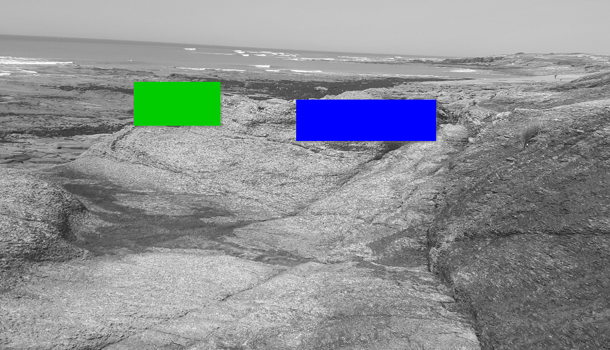
- Question 4 : Que voyez vous sous la zone bleue ? De quoi s'agit-il et que lui est-il arrivé ?
- Question 4 : What do you see under the blue zone? What is it and what happened to it?
- Question 5 : Décrivez la roche que vous voyez sous la zone verte (couleur, strates régulières ou non, taille des cristaux, dureté). Déduisez en la zone de la métarhyolite ou vous vous trouvez.
- Question 5 : Describe the rock you see under the green zone (color, regular or irregular strata, crystal size, hardness). Deduct in the metarhyolite area where you are.
Vous pouvez vous loguer sans attendre notre confirmation,
mais vous devez nous envoyer les réponses par mail en même temps via notre profil (
fafahakkai).
S'il y a des problèmes avec vos réponses nous vous en ferons part.
Les logs enregistrés sans réponses seront supprimés.Une photo de vous ou de votre GPS à un des WPs (mais sans prendre en photo le panneau ou les spots d'observation) serait la bienvenue, mais n'est pas obligatoire
You can log this cache without waiting for our confirmation, but you must send us the answers by e-mail at the same time via our profile (fafahakkai).
If there is a problem with your answers we will notify you. The logs recorded without answers will be deleted.
A picture of you or your GPS to a WPs (but not to photograph the sign or observation spots) would be welcome but is not mandatory.
Rappel concernant les « Earthcaches »: Il n'y a pas de conteneur à rechercher ni de logbook à renseigner. Il suffit de se rendre sur les lieux, de répondre aux questions ci-dessus et de nous renvoyer les réponses.
Reminder concerning "Earthcaches": there is neither a container to look for nor a logbook to sign. One need only go to the location, answer to the differents quiestions and send us the answers.