
La Earthcache / The Earthcache
► Contexte géologique local
Le site de Chaudeyrolles présente une situation lithographique et topographie complexe.
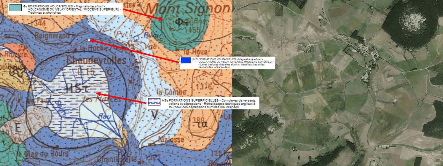
C'est le fruit de d'une longue histoire volcanique avec les trois types de volcanisme dont le plus récent et le plus structurant a donné naissance aux Narces de Chaudeyrolles.
► Histoire volcanique de Chaudeyrolles
~ Episode 1 : le volcanisme basaltique du Velay oriental
Ce volcanisme basaltique datant du Miocène supérieur (12 Ma) a donné à un volcan en cône.
Ses formations sont issues de laves fluides basiques donnant du basalte sur de vastes plateaux.
Le basalte est une roche sombre gris-bleutée, cohérente, non grenue avec des vacuoles de gaz.

A ces formations cristallines s'ajoutent des dépôts de pyroclastes dont les bombes volcaniques. Dans un volcanisme basique, ces bombes ont des formes en fuseau ou en bouse de vache.

~ Episode 2 : un volcanisme phonolitique, le Mont Signon
Le Mont Signon est un ancien volcan en dôme de type péléen de 1454 mètres formé il y a 7 Ma.
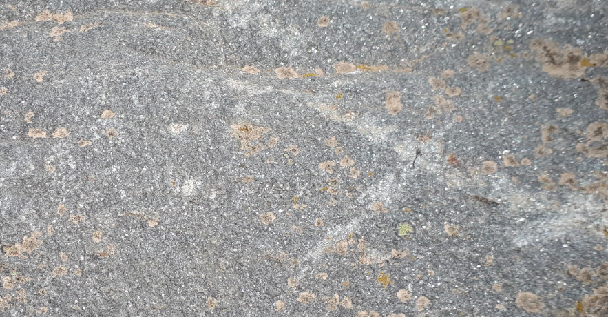
Il est constitué de phonolite, une roche massive de couleur gris claire avec une structure microlithique fluidale. Elle ne présente pas de vacuole de gaz.
Son observation permet de voir de nombreux petits cristaux brillants, des feldspaths alcalins.
~ Episode 3 : un épisode phréatomagmatique , naissance du chaudron de Chaudeyrolles
A Chaudeyrolles, les dernières manifestations sont un volcanique phréatomagmatique du quaternaire, la plus ancienne phase d'activité des jeunes volcans d'Ardèche.
Ce "volcan geyser" est à l'origine d'un maar, le chaudron de Chaudeyrolles, la partie émergée d'une formidable machine à vapeur que nous allons découvrir.
► Du Maar au Narces, évolution du chaudron de Chaudeyrolles
~ Chapitre 1 : le cataclysme phréatomagmatique, naissance du maar
Le maar de Chaudeyrolles correspond à un cratère caractéristique d’une éruption phréato-magmatique. De forme circulaire, il ne présente pas de relief comme un cône ou un dome.
A l'origine de sa formation, de l'eau s'infiltre par des fissures dans les profondeurs et rencontre le magma brûlant qui remonte.
Son évaporation en vapeur d'eau génère des pressions fantastiques qui entraînent des explosions spectaculaires : c'est le principe d'une cocotte minute sans soupape.

La vaporisation de l'eau à haute énergie pulvérise les roches situées au dessus, ici principalement le vieux plateau basaltique décrit au Chapitre 1.
A l’aplomb du diatrème se met en place un vaste cratère circulaire. Constamment arasé par le souffle des explosions, il reste affleurant et ne forme pas de cône ou de dôme.
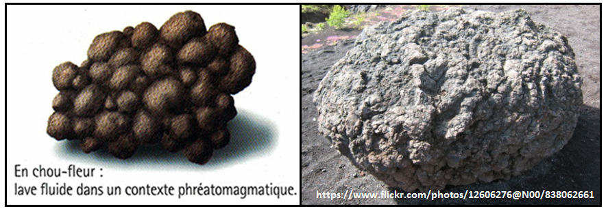
Autour du cratère se forment des anneaux de projections pyroclastiques issus du substrat basaltique.
Ces anneaux peuvent contenir des bombes volcaniques prenant un aspect caractéristique « en chou-fleur » : bombes trempées, très denses, sans bulle et à surface variqueuse.
~ Chapitre 2 : Le maar, un entonnoir bien rempli
Le Cratère de Chaudeyrolles mis en place à la fin de l'épisode actif est le plus vaste du Velay, avec un diamètre de 1.5 kilomètres et une profondeur de la cheminée à l'aplomb de 400 mètres.
Sa cheminée est en grande partie remplie d'éboulis.

~ Chapitre 3 : du Maar à la Mare
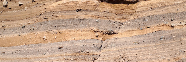
A Chaudeyrolles, l’arrivée de lave s’interrompt assez rapidement et n'a pas le temps de remplir l'entonnoir formé par les explosions. Le contexte hydrographique le permettant (pluies abondantes, fortes pentes, présence d'un réseau hydrographique), le cratère se remplit pour former un lac.
A cet écoulement fluvial s'ajoute une érosion des montagnes alentours (Mont Signon, plateaux basaltiques) apportant de grandes quantités de sédiments qui tapissent le fond du lac.
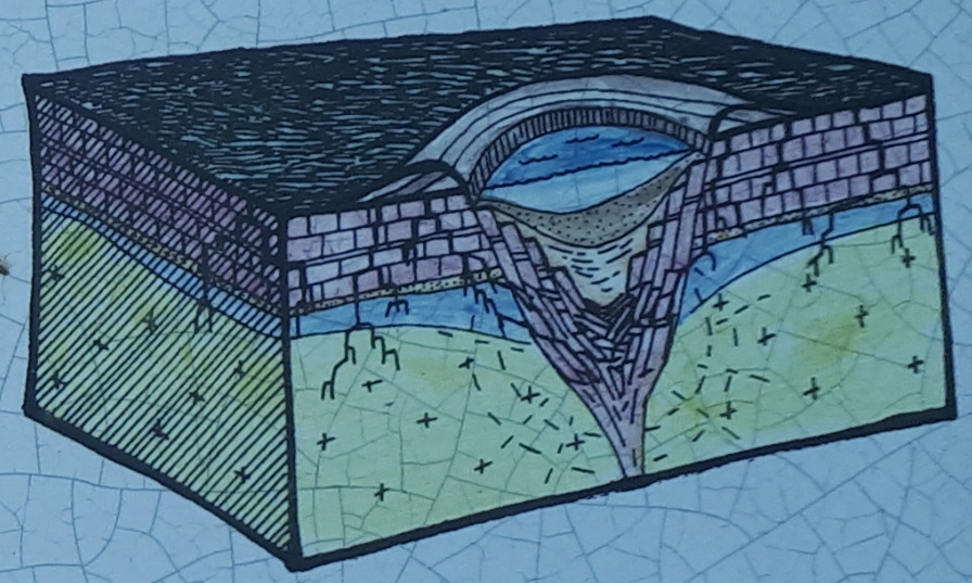
~ Chapitre 4 : de la Mare aux Narces
En géomorphologie, une narce (du latin nartia, «marécage») est une zone humide, une tourbière.
Dans le cas de Chaudeyrolles, la poursuite de l'érosion des massifs alentours a continué à apporter des sédiments comblant petit à petit le lac.
Une végétation typique s'est installée pour former une tourbière principalement composée de sphaignes, accélérant le comblement du lac par un remplissage organo-détritique.

Le fond de l'ancien lac est aujourd'hui recouvert de tourbe d'environ 3 à 4 mètres d'épaisseur.
Les parties plus périphériques du Narce ont été drainées pour permettre un usage agricole, mais l'anneau central qui comprend la partie où la tourbe est la plus ancienne et la plus épaisse est toujours en place ; il s'agit de la tourbière haute active, cœur de la Narce.
Cette zone se repère par une végétation de marais, de hautes herbes et une coloration d'un vert beaucoup plus intense et foncé que les espaces cultivés alentours.
► Local geological context
The Chaudeyrolles site presents a complex lithographic and topographical situation.
It is the fruit of a long volcanic history with the three types of volcanism, the most recent and the most structuring of which gave birth to the Narces de Chaudeyrolles.
► Chaudeyrolles volcanic history
~ Episode 1: the basaltic volcanism of the eastern Velay
This basalt volcanism dating from the Upper Miocene (12 Ma) gave to a cone volcano.
Its formations come from basic fluid lavas giving basalt on large plateaus.
Basalt is a dark bluish-gray, coherent rock, ungrained with gas vacuoles.
To these crystalline formations are added deposits of pyroclasts, including volcanic bombs. In basic volcanism, these bombs have spindle or cow dung shapes.
~ Episode 2: phonolitic volcanism, Mont Signon
Mont Signon is an ancient Pelean-type domed volcano of 1454 meters formed 7 Ma ago.
It consists of phonolite, a massive light gray rock with a fluid microlithic structure. There is no gas vacuole.
Its observation allows to see many small brilliant crystals, alkaline feldspars.
~ Episode 3: a phreatomagmatic episode, birth of the Chaudeyrolles cauldron
In Chaudeyrolles, the last manifestations are a quaternary phreatomagmatic volcanic, the oldest phase of activity of the young volcanoes of Ardèche.
This "geyser volcano" is the source of a maar, the Cauldron of Chaudeyrolles, the tip of a formidable steam engine that we will discover.
► From Maar to Narces, evolution of the cauldron of Chaudeyrolles
~ Chapter 1: the phreatomagmatic cataclysm, birth of the ma
The Maar de Chaudeyrolles corresponds to a crater characteristic of a phreato-magmatic eruption. Circular in shape, it has no relief like a cone or a dome.
At the origin of its formation, water seeps through cracks in the depths and meets the burning magma which rises.
Its evaporation in water vapor generates fantastic pressures which cause spectacular explosions: it is the principle of a pressure cooker without valve.
The vaporization of high energy water pulverizes the rocks located above, here mainly the old basalt plateau described in Chapter 1.
At the base of the diatreme is a large circular crater. Constantly leveled by the blast of explosions, it remains flush and does not form a cone or dome.
Around the crater are formed rings of pyroclastic projections from the basaltic substrate.
These rings may contain volcanic bombs taking on a characteristic “cauliflower” appearance: hardened, very dense, bubble-free bombs with a varicose surface.
~ Chapter 2: The maar, a well-filled funnel
The Crater of Chaudeyrolles set up at the end of the active episode is the largest in Velay, with a diameter of 1.5 kilometers and a depth of the chimney above 400 meters.
Its chimney is largely filled with scree.
~ Chapter 3: from Maar to Mare
In Chaudeyrolles, the lava flow stops fairly quickly and does not have time to fill the funnel formed by the explosions. The hydrographic context allowing it (abundant rain, steep slopes, presence of a hydrographic network), the crater fills to form a lake.
To this fluvial flow is added an erosion of the surrounding mountains (Mont Signon, basaltic plateaus) bringing large amounts of sediment that line the bottom of the lake.
~ Chapter 4: from Mare to Narces
In geomorphology, a narce (from Latin nartia, "swamp") is a wetland, a bog.
In the case of Chaudeyrolles, the continued erosion of the surrounding massifs continued to provide sediments gradually filling the lake.
A typical vegetation settled to form a bog mainly composed of sphagnum, accelerating the filling of the lake by an organo-detritic filling.
The bottom of the old lake is now covered with peat about 3 to 4 meters thick.
The more peripheral parts of the Narce were drained to allow agricultural use, but the central ring which includes the part where the peat is the oldest and the thickest is still in place; it is the active high peat bog, the heart of Narce.
This area is marked by marsh vegetation, tall grass and a much more intense and dark green coloration than the surrounding cultivated areas.
► Sources bibliographiques / Bibliographical sources
Les Questions / The Questions
La lecture attentive du descriptif de la cache, ainsi qu'une observation des éléments de terrain et un peu de déduction sont normalement suffisants pour répondre aux questions de cette EarthCache.
A careful reading of the description of the cache, as well as observation of terrain features and some deduction is usually sufficient to answer questions of this EarthCache.
Questions pour valider :"Du Maar aux Narces à Chaudeyrolles"
Questions to validate: "From Maar aux Narces to Chaudeyrolles"
- Question 0 : Prenez une photo de vous ou d'un élément vous identifiant avec la Narce en arrière-plan.
Cette photo devra au choix nous être transmise avec les réponses ou être ajoutée à votre log.
-Question 0 : Take a picture of yourself or something identifying you with the Narce in the background.
This photo must either be sent to us with the answers or added to your log.
Point 1 : N 44° 56.904 E 004° 12.127
Vous voici dans la cuvette de Chaudeyrolles, vestige d'un ancien cratère volcanique.
Here you are in the Chaudeyrolles basin, a vestige of an old volcanic crater.
- Question 1 : Faites un tour d'horizon à 360 degrés ; quelle est la forme générale du cratère ? Décrivez la topographie de son intérieur. De quel type volcanisme est issu ce cratère ?
- Question 1 : Take a 360 degree tour; what is the general shape of the crater? Describe the topography of its interior. What type of volcanism did this crater come from?
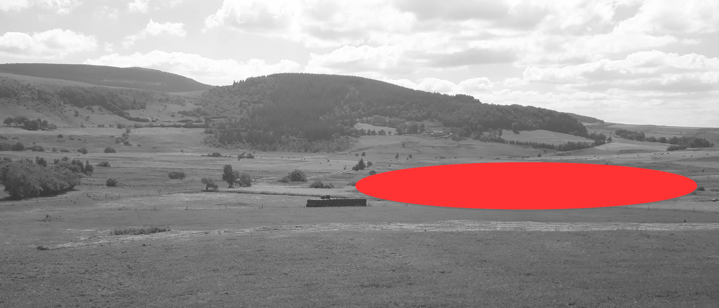
- Question 2 : Tournez vous vers le sud-ouest. Sous la zone rouge de la photo WP1, que distinguez vous ? Quelle différence par rapport au reste de la cuvette ? A quelle stade d'évolution se trouve ce cratère volcanique et quel nom lui donne t-on à ce stade ?
- Question 2 : Turn to the southwest. Under the red area of the WP1 photo, what do you see? What difference from the rest of the bowl? At what stage of evolution is this volcanic crater and what name do we give it at this stage?
Point 2 : N 44° 56.899 E 004° 12.155
Vous voici devant un mur de pierres fait de roches locales (photo WP2).
Here you are in front of a stone wall made of local rocks (photo WP2).
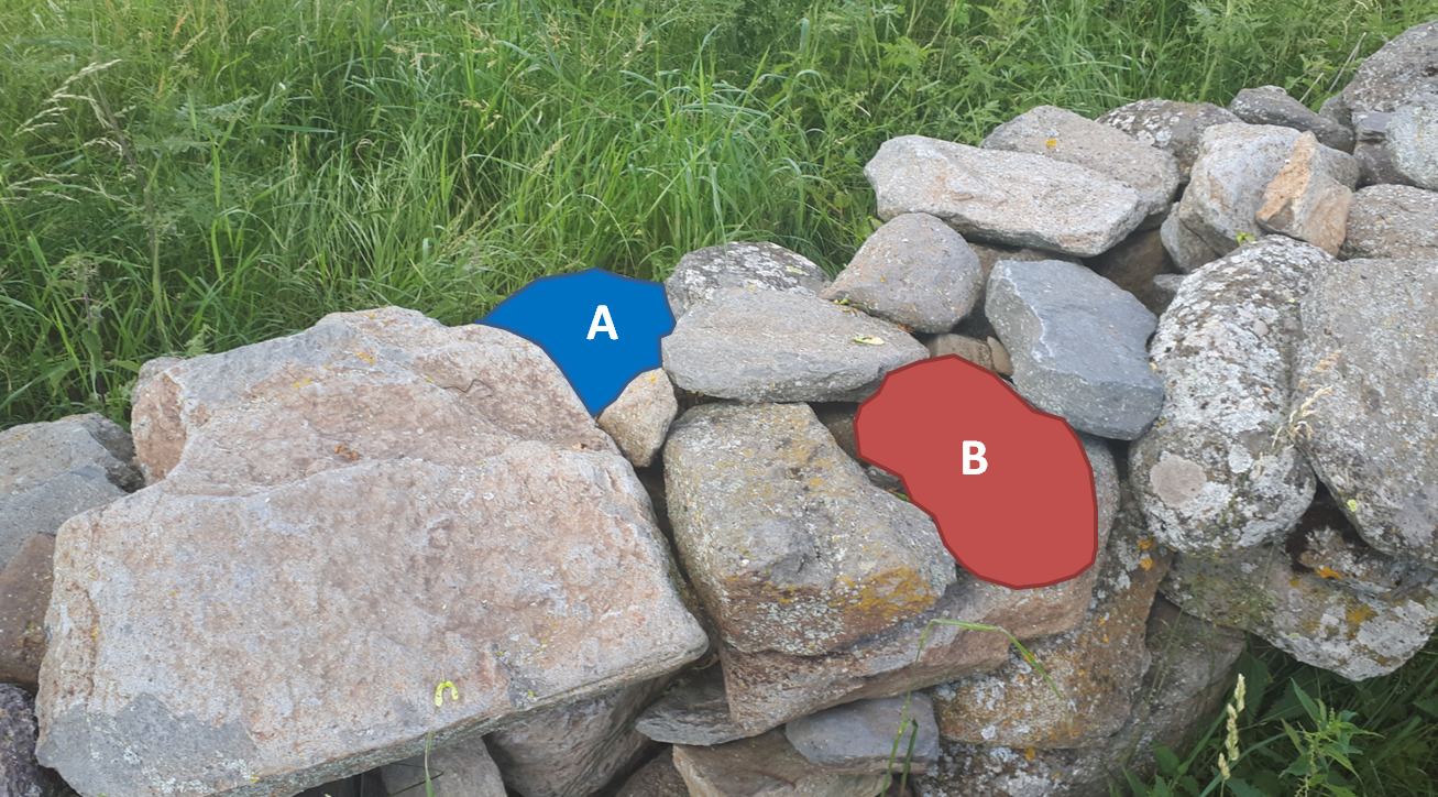
- Question 3 : Décrivez et identifiez la nature des roches sous la zone bleue A et la zone rouge B ; quelles sont leur nature ? Laquelle de ces deux roches est issue de l'activité du cratère volcanique où nous nous trouvons ?
- Question 3 : Describe and identify the nature of the rocks under the blue zone A and the red zone B; what are their nature? Which of these two rocks comes from the activity of the volcanic crater where we are?
Point 3 : N 44° 56.894' E 4° 12.170'
Vous voici devant un panneau présentant le Maar de Chaudeyrolles et le Mont Signon.
Here you are in front of a panel presenting the Maar de Chaudeyrolles and the Mont Signon.
- Question 4 : Quel est l'âge du maar de Chaudeyrolles ? Cette âge est-il cohérent avec votre réponse à la question 2 ?
- Question 4 : How old is the Chaudeyrolles maar? Is this age consistent with your answer to question 2?
- Question 5 : Le Mont Signon est-il fait d'une des deux roches découvertes au WP2 ? Justifiez votre réponse.
- Question 5 : Is Mont Signon made of one of the two rocks discovered at WP2?
Point 4 : N 44° 56.611 E 004° 12.101
Vous voici devant un panneau présentant les étapes de formation du chaudron de Chaudeyrolles.
You are in front of a panel presenting the stages in the formation of the Chaudeyrolles cauldron.
- Question 6 : Quelle est l'épaisseur des sédiments tapissant le fond de l'entonnoir du Maar et comment se sont-ils déposés là ? Ces éléments confirment-ils vos observations et déductions des questions 1 et 2 ?
- Question 6 : How thick is the sediment lining the bottom of the Maar funnel and how did it settle there? Do these elements confirm your observations and deductions from questions 1 and 2?
Vous pouvez vous loguer sans attendre notre confirmation,
mais vous devez nous envoyer les réponses en même temps soit par mail via notre profil (
fafahakkai), soit via la messagerie geocaching.com (Message Center).
S'il y a des problèmes avec vos réponses nous vous en ferons part.
Les logs enregistrés sans réponses et la photo seront supprimés.
You can log this cache without waiting for our confirmation, but you must send us the answers at the same time, by e-mail via our profile (fafahakkai) or by the system of Message Center of geocaching.com.
If there is a problem with your answers we will notify you. The logs recorded without answers and the photo will be deleted.
Rappel concernant les « Earthcaches »: Il n'y a pas de conteneur à rechercher ni de logbook à renseigner. Il suffit de se rendre sur les lieux, de répondre aux questions ci-dessus et de nous renvoyer les réponses.
Reminder concerning "Earthcaches": there is neither a container to look for nor a logbook to sign. One need only go to the location, answer to the differents questions and send us the answers.