
La Earthcache / The Earthcache
Le Puy en Velay s'étend sur un bassin que dominent d'imposantes tours naturelles ; le rocher Corneille, le rocher de l’Aiguilhe, le rocher de Saint-Joseph.
Qui sont-elles et comment sont-elles arrivées là ?
Nous allons nous partir à la découverte du rocher de l’Aiguilhe pour découvrir cela.
► Contexte géologique local
Le bassin du Puy en Velay montre des formations alluviales sur un substrat sédimentaire (Marnes de l'Oligocène) avec en son centre des anomalies topographiques et géologiques, des necks de formations basanitiques.

Ces necks présentent un alignement parallèle à un réseau de failles orientées Nord-Ouest/Sud-Est.
► Le Neck de Saint Michel, racine d'un volcan surtseyen
~ Au départ était le socle hercynien au milieu d'un paisible lac
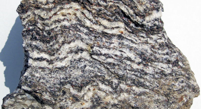
Le socle de la région est le granite à cordiérite du Velay, un granite hétérogène qui s'est mis en place à l'orogenèse hercynienne (-400 Ma).
Il présente de nombres enclaves :
- Du gneiss, une roche métamorphique de composition granitique. Il s'agit d'une roche claire et massive, à grain fin et présentant une foliation avec une alternance de petits lits clairs (quartz et de feldspath) et de fins niveaux sombres (biotite et amphibole).
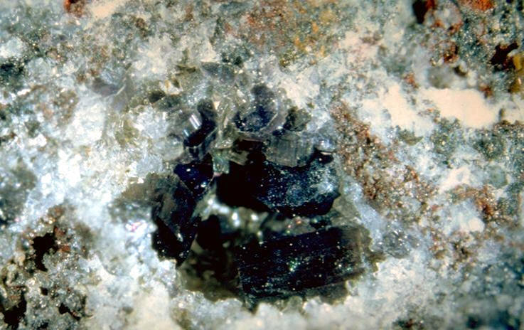
- Des enclaves de quartz (cristal gris-blanc brillant) pouvant avoir de la cordiérite, un minéral d'éclat vitreux à mat et de couleur bleue.
Il y a 35 millions d'années, ce socle hercynien s'est effondré pendant l'orogenèse alpine, permettant la mise en place d'un immense lac alimenté par la proto-Loire.
La couche terrestre a continué à s'affiner, permettant la mise en place d'une intense activité volcanique particulière, le volcanisme surtseyen
~ Puis vinrent les volcans
Il y a 3 millions d'années, le magma est remonté à la surface en plusieurs endroits en suivant une ligne de failles pré-existantes d'orientation Nord-Ouest/Sud-Est et a rencontré la zone lacustre du bassin du Puy en Velay. S'est alors déclenché un volcanisme phréatomagmatite de type surtseyen.
La lave a rencontré de grandes quantités d’eau en arrivant à la surface. De nombreuses explosions, peu violentes, ont fragmenté la lave pulvérisée qui est retombée aussitôt dans l’eau.
Les débris se sont agglomérés en couches, se sont soudés puis transformés en un matériau brun clair, la Brèche du Puy, formant un cône volcanique incomplet. Ce cône s'est fracturé pendant les éruptions, permettant des remontées de lave liquide se transformant en dykes.
A la fin de l'épisode volcanique, les lacs ont disparu et l'érosion a fait disparaître la partie supérieure des cônes, faisant apparaître à l'air libre la racine profonde de l’ancienne cheminée.
► La Brèche du Puy
La brèche du Puy est un tuf hyaloclastique à bloc cimenté de palagonite.
La lave basaltique pulvérisée subit instantanément dans l’eau un phénomène de trempe qui la vitrifie.
Les couches formées sont gorgées d’eau et subissent, très rapidement après l’éruption, une palagonitisation (altération du verre volcanique par hydratation) plus ou moins complète et consécutivement une induration.
La palagonite formée est un produit argileux ocre jaune qui cimente la brèche, la consolidant et en faisant une roche très résistante.
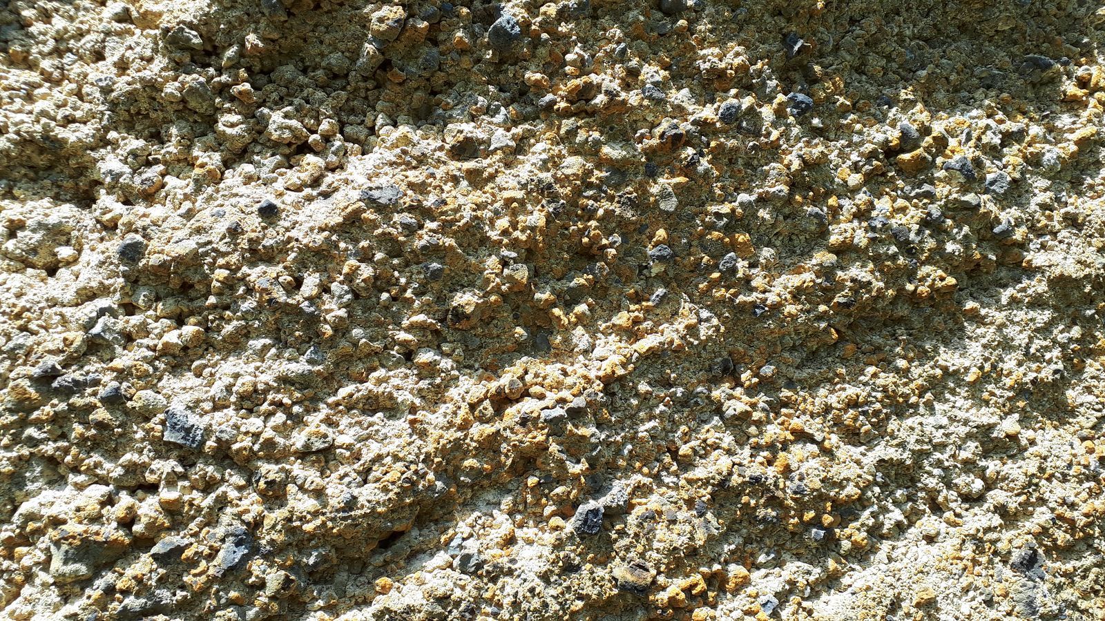
Ces tufs jaunes indurés contiennent également des morceaux du socle arrachés par le volcan et non complètement fondus.
► Le Dyke, filon magmatique
Un dyke est un filon de roche qui s'est injecté dans une fracturation de l'encaissant. De ce fait, un dyke recoupe les autres roches qu'il traverse.
Ces veines de lave vont se refroidir progressivement, formant des filons basaltiques. Le basalte formé est une roche de couleur bleuté-grise sombre avec une structure microlithique (cristaux invisibles à l'oeil nu). C'est une roche très dure (dureté de Mohs supérieure à 5) et cohérente.

► Principes de datation géologique relative
Il existe plusieurs type de datation relative des roches et événements géologiques :
- Le principe de recoupement : Un événement (intrusion magmatique, faille, plissement) qui provoque un changement dans la géométrie des roches est postérieur à la dernière strate qu'il affecte. Autrement dit, tout événement géologique qui en recoupe un autre lui est postérieur.
- Le principe d'inclusion : Les morceaux de roche inclus dans une autre couche sont plus anciens que leur contenant.Toute inclusion est plus ancienne que la structure qui l'entoure.
Ci-dessous le filon F est postérieur aux strates 1 et 2. L'inclusion I est antérieure à 2.

Le Puy en Velay stretches over a basin dominated by imposing natural towers; the Corneille rock, the Aiguilhe rock, the Saint-Joseph rock.
Who are they and how did they get there?
We are going to explore the rock of the Aiguilhe to discover this.
► Local geological context
The Puy en Velay basin shows alluvial formations on a sedimentary substrate (Oligocene marls) with in its center topographic and geological anomalies, necks of basanitic formations.
These necks have an alignment parallel to a network of faults oriented North-West / South-East.
► The Neck of Saint Michel, root of an overtseyen volcano
~ At the start was the Hercynian basement in the middle of a peaceful lake
The basement of the region is the cordierite granite of Velay, a heterogeneous granite which was set up during the Hercynian orogeny (-400 Ma).
It has enclave numbers:
- Gneiss, a metamorphic rock of granitic composition. It is a clear and massive rock, fine-grained and presenting a foliation with an alternation of small clear beds (quartz and feldspar) and fine dark levels (biotite and amphibole).
- Quartz enclaves (brilliant gray-white crystal) which may have cordierite, a mineral with a glassy to matt luster and blue color.
35 million years ago, this Hercynian base collapsed during the Alpine orogeny, allowing the establishment of a huge lake fed by the proto-Loire.
The earth's layer continued to thin, allowing the establishment of an intense particular volcanic activity, the overtseyen volcanism.
~ Then came the volcanoes
3 million years ago, the magma rose to the surface in several places following a pre-existing fault line of North-West / South-East orientation and encountered the lacustrine zone of the Puy en Velay basin . Then triggered a supersseyen-type phreatagagmatite volcanism.
The lava encountered large amounts of water on reaching the surface. Numerous, not very violent explosions fragmented the pulverized lava which immediately fell into the water.
The debris is agglomerated in layers, welded and then transformed into a light brown material, the Brèche du Puy, forming an incomplete volcanic cone. This cone fractured during the eruptions, allowing upwelling of liquid lava transforming into dykes.
At the end of the volcanic episode, the lakes disappeared and erosion made the upper part of the cones disappear, making the deep root of the ancient chimney appear in the open air.
► The Brèche of Puy
La brèche du Puy is a hyaloclastic tuff with a cement block of palagonite.
The sprayed basalt lava instantly undergoes a quenching phenomenon in the water which vitrifies it.
The layers formed are waterlogged and undergo, very quickly after the eruption, a palagonitization (alteration of the volcanic glass by hydration) more or less complete and subsequently induration.
The formed palagonite is a yellow ocher clay product which cements the breach, consolidating it and making a very resistant rock.
These hardened yellow tuffs also contain pieces of the base torn off by the volcano and not completely melted.
► The Dyke, magmatic vein
A dyke is a vein of rock which has been injected into a fracturing of the surrounding. As a result, a dyke cuts across the other rocks it crosses.
These lava veins will gradually cool, forming basaltic veins. The basalt formed is a dark bluish-gray colored rock with a microlithic structure (crystals invisible to the naked eye). It is a very hard rock (Mohs hardness greater than 5) and consistent.
► Principles of relative geological dating
There are several types of relative dating of rocks and geological events:
- The principle of overlap: An event (magmatic intrusion, fault, folding) which causes a change in the geometry of the rocks is posterior to the last stratum which it affects. In other words, any geological event which overlaps another one is subsequent to it.
- The principle of inclusion: The pieces of rock included in another layer are older than their container. Any inclusion is older than the structure that surrounds it.
Below vein F is posterior to strata 1 and 2. Inclusion I is prior to 2.
Ci-dessous le filon F est postérieur aux strates 1 et 2. L'inclusion I est antérieure à 2.
► Sources bibliographiques / Bibliographical sources
Les Questions / The Questions
La lecture attentive du descriptif de la cache, ainsi qu'une observation des éléments de terrain et un peu de déduction sont normalement suffisants pour répondre aux questions de cette EarthCache.
A careful reading of the description of the cache, as well as observation of terrain features and some deduction is usually sufficient to answer questions of this EarthCache.
ATTENTION ! L'accès au rocher de Saint Michel l’Aiguilhe est payant et soumis à horaires. Pour plus d'informations, allez sur :
WARNING ! Access to the rock of Saint Michel l'Aiguilhe is chargeable and subject to timetables. For more information, go to:
https://www.rochersaintmichel.fr/tarifs-horaires/
Questions pour valider :"Le Neck de Saint Michel d'Aiguilhe"
Questions to validate: "The Neck of Saint Michel d'Aiguilhe"
- Question 0 : Prenez une photo en Noire et Blanc de vous ou d'un élément vous identifiant avec la chapelle Saint Michel au sommet en arrière-plan.
Cette photo devra au choix nous être transmise avec les réponses ou être ajoutée à votre log.
-Question 0 : Take a black and white photo of yourself or an item identifying yourself with the Saint Michel chapel at the top in the background.
This photo must either be sent to us with the answers or added to your log.
Point 1 : N 45° 03.002 E 003° 52.970
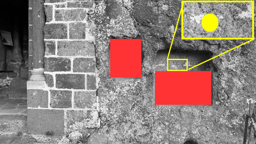
Depuis le niveau de l'Oratoire Saint Gabriel, compter 92 marches ; à ce niveau, regarde la falaise du rocher Saint Michel. Sur la photo WP1, vous pouvez voir 3 zones (A rouge, B bleue, C vert).
From the level of Saint Gabriel's Oratory, count 92 steps; at this level, look at the cliff of the Saint Michel rock. On the photo WP1, you can see 3 zones (A red, B blue, C green).

- Question 1 : Décrivez ce que vous voyez sous la zone A rouge (texture, litage, couleur, dureté). De quoi s'agit-il et quelle est sa nature et son origine ?
- Question 1 : Describe what you see under the red zone A (texture, bedding, color, hardness). What is it and what is its nature and origin?
- Question 2 : Dans la zone rouge, sous la zone B, décrivez la roche que vous voyez (texture, couleur, dureté). Quelle est sa nature ? Comment est-elle arrivée là ?
- Question 2 : In the red zone, under zone B, describe the rock you see (texture, color, hardness). What is its nature ? How did she get there?
- Question 3 : En utilisant les principes de datation relative et les informations du descriptif, estimez les âges relatifs des zones A, B et C.
- Question 3 : Using the principles of relative dating and descriptive information, estimate the relative ages of zones A, B and C.
Point 2 : N 45° 02.997 E 003° 52.954
Vous voici au sommet du rocher de Saint Michel, devant l'entrée de la chapelle (photo WP2).
Here you are at the top of the Saint Michel rock, in front of the entrance to the chapel (photo WP2).
- Question 4 : Décrire la roche formant le support du mur droit de l'entrée sous la zone rouge. Quelle sont sa nature et ses conditions de formation ?
- Question 4 : Describe the rock forming the support for the right wall of the entrance under the red zone. What are its nature and training conditions?
- Question 5 : Sous la zone jaune, observez la roche (couleur, taille des cristaux). En vous aidant du descriptif, déterminer sa nature.
- Question 5 : Under the yellow area, observe the rock (color, size of the crystals). With the help of the description, determine its nature.
- Question 6 : Tournez vous vers le rocher Corneille et sa statue Notre Dame de France, et avec votre boussole, notez la direction de ce rocher par rapport à Saint Michel. Expliquez cette orientation dans le cadre du contexte tectonique local.
- Question 6 : Turn to the Corneille rock and its Notre Dame de France statue, and with your compass, note the direction of this rock in relation to Saint Michel. Explain this orientation in the context of the local tectonic context.
Vous pouvez vous loguer sans attendre notre confirmation,
mais vous devez nous envoyer les réponses en même temps soit par mail via notre profil (
fafahakkai), soit via la messagerie geocaching.com (Message Center).
S'il y a des problèmes avec vos réponses nous vous en ferons part.
Les logs enregistrés sans réponses et la photo seront supprimés.
You can log this cache without waiting for our confirmation, but you must send us the answers at the same time, by e-mail via our profile (fafahakkai) or by the system of Message Center of geocaching.com.
If there is a problem with your answers we will notify you. The logs recorded without answers and the photo will be deleted.
Rappel concernant les « Earthcaches »: Il n'y a pas de conteneur à rechercher ni de logbook à renseigner. Il suffit de se rendre sur les lieux, de répondre aux questions ci-dessus et de nous renvoyer les réponses.
Reminder concerning "Earthcaches": there is neither a container to look for nor a logbook to sign. One need only go to the location, answer to the differents questions and send us the answers.