
La Earthcache / The Earthcache
La Colline de Saint Roch est le vestige d'une histoire géologique complexe, mélant plusieurs types de volcaniques, dont l'érosion et l'activité humaine a mis un jour les principales formations, permettant d'en comprendre son histoire géologique.
► Contexte Géologique Local
La colline de Saint Roch présente principalement 2 formations géologiques selon la carte du BRGM :
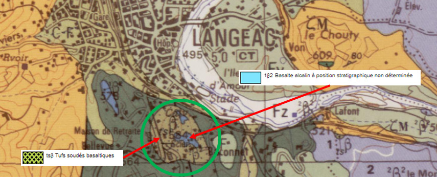
- Sa partie basale et ses flancs sont formés de tufs soudés basaltiques.
- Sa partie supérieure et sommitale est constituée de basalte alcalin.
Ces formations et leur disposition reflètent l'histoire géologique de la colline de Saint Roch.
► Histoire géologique de Saint Roch
~ Episode 1, le phréatomagmatisme
Il y a 7 millions d'années, un phénomène de type hydromagmatique, né de la rencontre du magma basaltique ascendant avec une surface d'eau s'est mis en place dans la zone de Saint Roch.
Le phréato-magmatisme est un volcanisme particulier se faisant systématiquement en présence d'eau ; ce volcanisme présente lui-même plusieurs déclinaisons selon la quantité d’eau en contact avec le magma, aboutissant à trois régimes possibles.
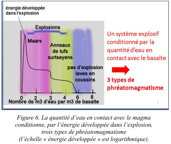
- deux régimes explosifs :
• le premier, le plus violent, de type maar, est souvent dû à la rencontre en profondeur du magma avec une nappe phréatique.
Nous sommes dans une principe de machine à vapeur : quand le magma rencontre l’eau, le plus souvent en profondeur, celle-ci est non seulement complètement vaporisée mais aussi surchauffée.
Il en résulte une succession d'explosions dont les projections s'accumulent pour former des anneaux de projections.
Cette formation est peu cohérente, instable, constituée de matériaux de taille très hétérogènes issues des formations environnantes pré-existantes (superficielles ou du socle).
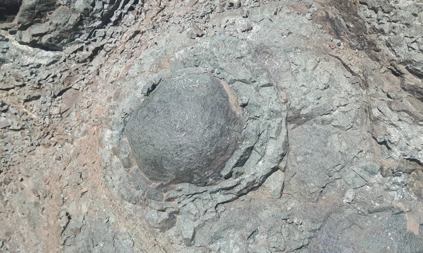
• le second, de type surstseyen, est spécifique à la rencontre du magma avec un volume d’eau plus important (bord de mer, lac...).
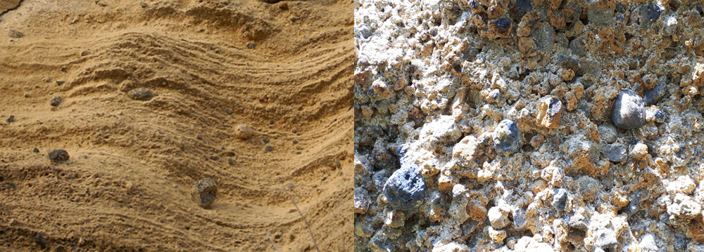
La lave basaltique pulvérisée subit instantanément dans l’eau un phénomène de trempe qui la vitrifie. Les couches formées sont gorgées d’eau et subissent, très rapidement après l’éruption, une palagonitisation (altération du verre volcanique par hydratation) plus ou moins complète et consécutivement une induration.
La palagonite formée est un produit argileux ocre jaune qui cimente la brèche, la consolidant et en faisant une roche très résistante.
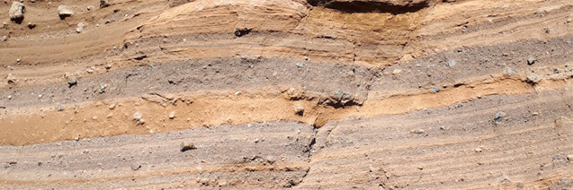
Ces tufs jaunes indurés montrent différents types de granoclassement, de variations d’épaisseurs, de figures diverses (entrecroisement, biseautage, emboîtement) et peuvent apparaître lités (en couches superposées) ou massifs.
- un régime non explosif :
Ce troisième type de formation se produit au fond des océans dans des rides médio-océaniques.
Nous sommes dans un régime purement effusif ; la lave sortant à une température de 1000°C se couvre d'une pellicule de verre qui forme une sorte de baudruche souple, progressivement gonflée par la lave qui continue d'être émise.
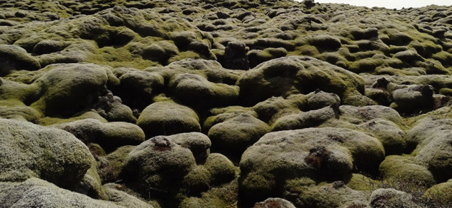
Les laves forment ainsi des boules visqueuses qui s'empilent et se moulent les uns sur les autres, aboutissant à des empilements en forme de coussins d'une taille de plusieurs mètres.
On parle de formations de laves en coussins, ou pillow lava, caractéristiques des plateaux islandais.
~ Episode 2, le volcanisme strombolien
Au fil du temps et de l'accroissement du volcan, celui-ci vient à l'air libre et cette fois la lave qui s'en échappe, fluide, peut s'écouler librement sans contact avec l'eau et forme des structures de volcanismes plus classiques, sous la forme de coulées de laves basaltiques sombres et très dures, plus dures que les formations phréatomagmatique sous jacente.
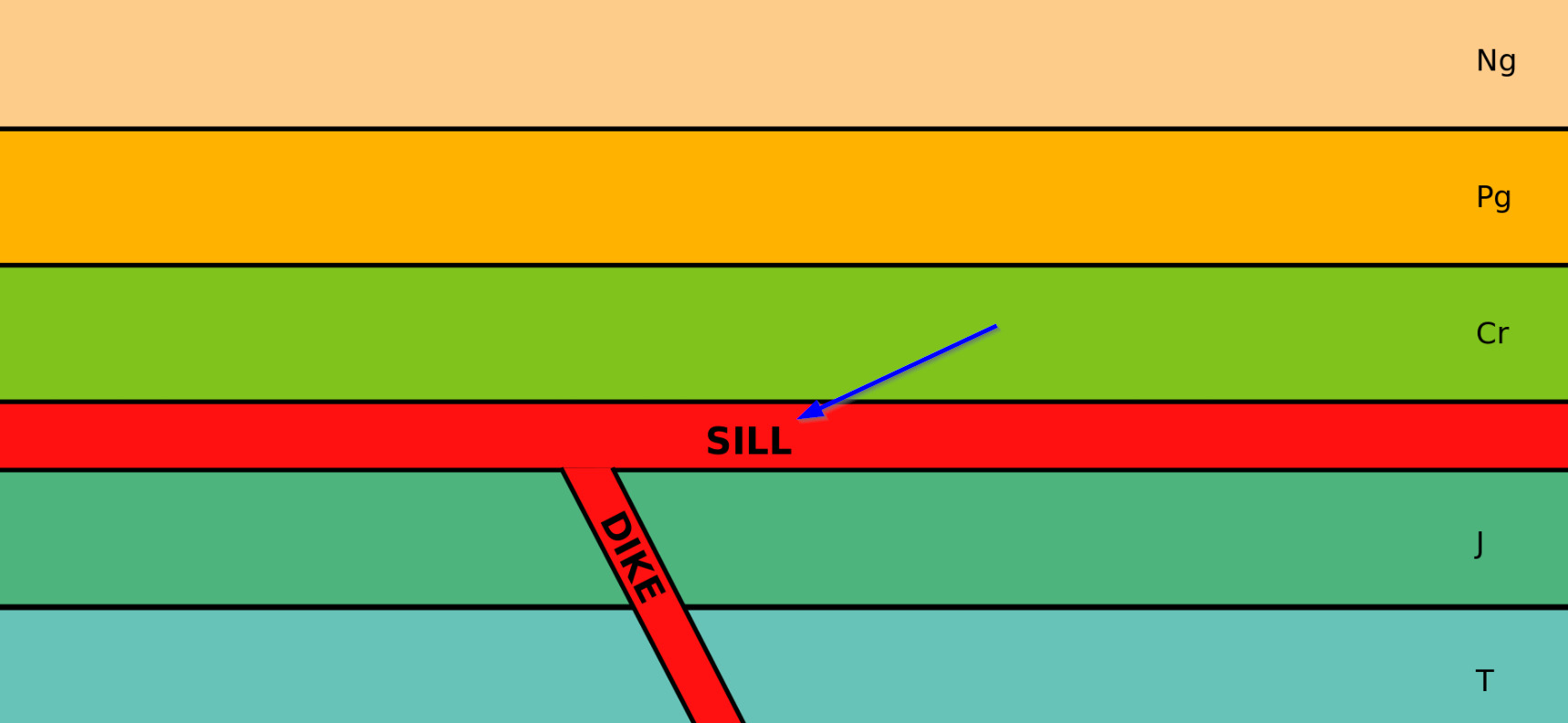
Les traces de cet épisode strombolien terminal va se matérialiser sous la forme de sills, des filon-couches de roches magmatiques souvent horizontaux infiltrés entre les couches de roches plus anciennes (ici les formation phréatomagmatique).
~ Episode 3, Erosion et diamètre
Il y a moins de 6 millions d'années, l'activité volcanique au niveau de Saint Roch s'interrompt, entraînant alors l'érosion des formations mises en place.
Au fur et à mesure de cette érosion, la cheminée du volcan (diatrème), est mise à à l'air libre.
Cette mise à l'air libre est accélérée par les nombreuses carrières qui couvrent les flancs du cône.
On peut alors y observer plusieurs zones :
- La formation palagonitique de l'épisode phréatomagmatique, sous la forme de formations litées subhorizontales.
- la cheminée (diatrème) dans la partie centrale. Elle n’est pas remplie de lave refroidie comme celle d’un volcan strombolien, mais plutôt de couches inclinées, effondrées suivant une géométrie dictée par des lignes de faille bien visibles.
Cette zone massive est marquée par un litage moins net et régulier, par la présence de failles annulaires ou verticales délimitant des panneaux de brèches effondrés dans la cheminée.
- les filons de basalte noirs qui recoupent l’ensemble des formations précédentes et ont subi les mêmes déformations que les formations sous-jacentes, témoignant d’une subsidence marquée.
Le calvaire sommital est édifié sur les restes d’un petit lac de lave (coulée de basalte massif) qui caractérise la phase éruptive terminale, de type strombolien (à l’air libre).
The Hill of Saint Roch is the vestige of a complex geological history, mixing several types of volcanics, whose erosion and human activity has brought to light the main formations, allowing its geological history to be understood.
► Local Geological Context
The hill of Saint Roch mainly presents 2 geological formations according to the BRGM map:
- Its basal part and its sides are formed of basalt welded tuffs.
- Its upper and upper part consists of alkaline basalt.
These formations and their arrangement reflect the geological history of the hill of Saint Roch.
► Geological history of Saint Roch
~ Episode 1, phreatomagmatism
7 million years ago, a hydromagmatic type phenomenon, born from the meeting of the ascending basaltic magma with a surface of water, took place in the Saint Roch area.
The phreato-magmatism is a particular volcanism occurring systematically in the presence of water; this volcanism itself has several variations depending on the amount of water in contact with the magma, resulting in three possible regimes.
- two explosive regimes:
• the first, the most violent, of the maar type, is often due to the deep encounter of the magma with a water table.
We are in the principle of a steam engine: when the magma meets water, most often in depth, it is not only completely vaporized but also overheated.
This results in a succession of explosions, the projections of which accumulate to form rings of projections.
This formation is not very coherent, unstable, made up of very heterogeneous size materials coming from the pre-existing surrounding formations (superficial or of the base).
• the second, surstseyen type, is specific to the meeting of magma with a larger volume of water (seaside, lake ...).
The sprayed basalt lava instantly undergoes a quenching phenomenon in the water which vitrifies it. The layers formed are waterlogged and undergo, very quickly after the eruption, a palagonitization (alteration of the volcanic glass by hydration) more or less complete and subsequently induration.
The formed palagonite is a yellow ocher clay product which cements the breach, consolidating it and making a very resistant rock.
These hardened yellow tuffs show different types of grading, variations in thickness, various shapes (crisscrossing, beveling, interlocking) and can appear bedded (in superimposed layers) or massive.
- a non-explosive regime:
This third type of formation occurs at the bottom of the oceans in mid-oceanic wrinkles.
We are in a purely effusive regime; the lava leaving at a temperature of 1000 ° C. is covered with a film of glass which forms a sort of flexible balloon, progressively swollen by the lava which continues to be emitted.
The lavas thus form viscous balls which stack and mold on top of each other, resulting in stacks in the form of cushions with a size of several meters.
We speak of lava formations in cushions, or pillow lava, characteristic of the Icelandic plateaus.
~ Episode 2, Strombolian volcanism
Over time and the growth of the volcano, it comes to the open air and this time the lava which escapes from it, fluid, can flow freely without contact with water and form structures of more classic volcanisms, in the form of dark and very hard basalt lava flows, harder than the underlying phreatomagmatic formations.
The traces of this terminal Strombolian episode will materialize in the form of sills, sills of magmatic rocks often horizontal infiltrated between the layers of older rocks (here the phreatomagmatic formations).
~ Episode 3, Erosion and diameter
Less than 6 million years ago, volcanic activity at Saint Roch level stopped, causing erosion of the formations in place.
As this erosion progresses, the volcano's chimney (diatreme) is put into the open air. This venting is accelerated by the numerous quarries that cover the sides of the cone.
We can then observe several zones:
- The palagonitic formation of the phreatomagmatic episode, in the form of subhorizontal bedded formations.
- the chimney (diatreme) in the central part. It is not filled with cooled lava like that of a Strombolian volcano, but rather with inclined layers, collapsed according to a geometry dictated by clearly visible fault lines.
This massive zone is marked by a less clear and regular bedding, by the presence of annular or vertical faults delimiting panels of collapsed breccias in the chimney.
- the black basalt veins which cut across all of the previous formations and have undergone the same deformations as the underlying formations, testifying to a marked subsidence.
The summit calvary is built on the remains of a small lava lake (massive basalt flow) which characterizes the terminal eruptive phase, of Strombolian type (in the open air).
► Sources bibliographiques / Bibliographical sources
Les Questions / The Questions
La lecture attentive du descriptif de la cache, ainsi qu'une observation des éléments de terrain et un peu de déduction sont normalement suffisants pour répondre aux questions de cette EarthCache.
A careful reading of the description of the cache, as well as observation of terrain features and some deduction is usually sufficient to answer questions of this EarthCache.
Questions pour valider :"Volcanismes au pluriel à Saint Roch"
Questions to validate: "Volcanisms in the plural in Saint Roch"
Point 1 : N 45° 05.514 E 003° 29.810
Après avoir suivi les trailheads depuis la route, vous voici au fond de la carrière principale, devant le front de taille rendant visible l'ensemble des zones du volcan.
After following the trailheads from the road, you are at the bottom of the main quarry, in front of the face making all the areas of the volcano visible.
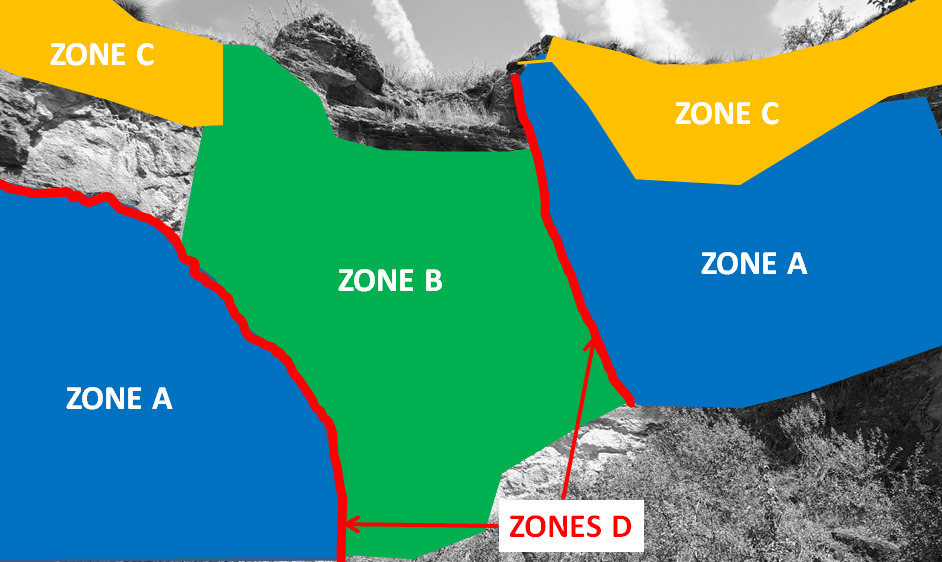
- Question 1 : A l'aide de la photo WP1, décrivez et identifiez les zones A, B, C et D en les reliant aux 4 points suivants : 1 - Diatrème / 2 - coulées de lave basaltique / 3 - lignes de faille annulaires / 4 - formations phréatomagmatiques.
- Question 1 : Using the photo WP1, describe and identify zones A, B, C and D by connecting them to the following 4 points: 1 - Diatreme / 2 - basalt lava flows / 3 - annular fault lines / 4 - formations phreatomagmatic.
Point 2 : N 45° 05.507 E 003° 29.793
Vous voici à l'entrée de la carrière, observez l'affleurement à gauche quand on y rentre (photo WP2).
Here you are at the entrance to the quarry, observe the outcrop on the left when you enter it (photo WP2).
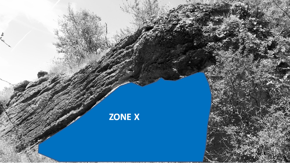
- Question 2 : Décrivez la roche de la zone X : déduisez-en le type de phréatomagmatisme et la nature de cette roche.
- Question 2 : Describe the rock in zone X: deduce the type of phreatomagmatism and the nature of this rock.
Point 3 : N 45° 05.572 E 003° 29.815
A la sortie de la carrière, prenez le chemin sur la droite pour contourner la colline par la gauche (le chemin de droite est fermé). Vous voici alors au sommet de la colline Saint Roch, au niveau d'une table d'orientation apportant des éléments complémentaires d'informations sur l'histoire géologique de la colline.
At the end of the quarry, take the path on the right to go around the hill on the left (the right path is closed). You are now at the top of Saint Roch hill, at an orientation table providing additional information on the geological history of the hill.
- Question 3 : D'après la plaque, quel est le type de volcanisme ? Cela confirme t-il vos observations et déductions du WP2 ? Justifier votre réponse.
- Question 3 : According to the plaque, what is the type of volcanism? Does this confirm your observations and deductions from WP2? Justify your answer.
- Question 4 : Prenez une photo en Noire et Blanc de vous ou d'un élément vous identifiant au niveau de la table d'orientation avec la vue sur l'Allier en arrière plan.
Cette photo devra au choix nous être transmise avec les réponses ou être ajoutée à votre log.
-Question 4 : Take a black and white photo of yourself or of an item identifying yourself at the orientation table with the view of the Allier in the background.
This photo must either be sent to us with the answers or added to your log.
Vous pouvez vous loguer sans attendre notre confirmation,
mais vous devez nous envoyer les réponses en même temps soit par mail via notre profil (
fafahakkai), soit via la messagerie geocaching.com (Message Center).
S'il y a des problèmes avec vos réponses nous vous en ferons part.
Les logs enregistrés sans réponses et la photo seront supprimés.
You can log this cache without waiting for our confirmation, but you must send us the answers at the same time, by e-mail via our profile (fafahakkai) or by the system of Message Center of geocaching.com.
If there is a problem with your answers we will notify you. The logs recorded without answers and the photo will be deleted.
Rappel concernant les « Earthcaches »: Il n'y a pas de conteneur à rechercher ni de logbook à renseigner. Il suffit de se rendre sur les lieux, de répondre aux questions ci-dessus et de nous renvoyer les réponses.
Reminder concerning "Earthcaches": there is neither a container to look for nor a logbook to sign. One need only go to the location, answer to the differents questions and send us the answers.