Decize
Confluence
Saint-Leger-des Vignes

Où sommes-nous ?
Située sur une colline orientée plein sud dominant la Loire, la ville produisit du vin jusqu'en 1879.
Quelques définitions
Une confluence, est le lieu où se rejoignent plusieurs cours d'eau pour couler dans un même lit.
Un affluent est un cours d’eau qui se jette dans un autre cours d'eau principal.
Le cours d’eau principal est visiblement plus large, plus puissant à l’œil nu que celui qui le rejoint,
Forces en présence
La Loire
La situation géographique et la constitution géologique du bassin versant de la Loire en font le plus irrégulier des grands fleuves de France.
La Loire est le plus long fleuve de France, avec une longueur de 1 006 kilomètres. Sa source se trouve sur le versant sud du mont Gerbier-de-Jonc, dans le département de l'Ardèche. Son embouchure vers l'océan Atlantique se trouve dans le département de la Loire-Atlantique,.
Son cours se décrit en plusieurs bassins hydrologiques successifs, ici nous sommes dans le sous bassin de la Loire supérieure, (jusqu’au bec d'Allier )

Dans cette région, la Loire creuse son lit vers le nord dans une couche d'éboulis et d'alluvions, de sables et d'argiles. Son cours s'assagit et ralentit, sa vitesse cesse d'être un handicap majeur pour la batellerie. Sortie du Massif central, juste avant le nivernais elle s'infléchit vers le nord-ouest et commence à remblayer son lit. C'est le début de cette particularité ligérienne : l'exhaussement du lit, qui est la cause directe de phénomènes particuliers à la Loire.
A une altitude de 192 mètres, d'une superficie de 918 hectares (dont 215 de forêt), la ville jouxte Decize à 32 kilomètres de Nevers. La jonction du Canal du Nivernais et du Canal Latéral à la Loire a entraîné un fort développement lié aux voies fluviales et aux canaux.
Il y a un siècle un barrage sur la Loire a été créé qui a eu pour effet l’ensablement de la vieille Loire devenue bras mort et qui permet aujourd’hui de mieux maîtriser les caprices de l’Aron.
Aron
L’ARON est une rivière du département de la Nièvre qui prend sa source dans l’étang du même nom, dans les forêts du Morvan, à 313 m d’altitude. Il rejoint dans la Loire à Decize après un parcours d’un peu plus de 110 kilomètres.
A Decize, au lieu-dit « pont d’Aron », la superficie du bassin de l’Aron (affluents compris) est de 1705 Km2 et le débit retenu est de 430 m3 /s. Le lit majeur est de taille très variable. Large et plat à l’amont de Châtillon-en-Bazois, il s’encaisse dans une étroite vallée jusqu'à Panneçot. Le lit mineur est très étroit, quelques mètres à une dizaine de mètres, et il ne s’élargit qu’avant d’arriver à Decize
Canal du Nivernais
Le canal du Nivernais est un canal entre le bassin de la Loire et celui de l'Yonne, entre Saint-Léger-des-Vignes, dans le département de la Nièvre, et Auxerre, préfecture du département de l'Yonne. le but initial est d’approvisionner Paris en bois de chauffage
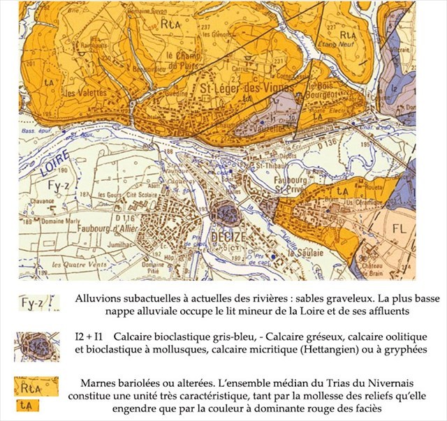
Quelques précisions sur les terrains.
Confluence of Saint-Leger-des Vignes
Where are we ?
Located on a south-facing hill overlooking the Loire, the city produced wine until 1879.
Some definitions
A confluence is the place where several rivers meet to flow in the same bed.
A tributary is a stream that flows into another main stream.
The main stream is visibly wider, more powerful to the naked eye than the one that joins it,
Forces in presence
The Loire
The geographic location and geological makeup of the Loire watershed make it the most irregular of the major rivers in France.
The Loire is the longest river in France, with a length of 1,006 kilometers. Its source is located on the southern slope of Mont Gerbier-de-Jonc, in the Ardèche department. Its mouth towards the Atlantic Ocean is in the Loire-Atlantique department.
Its course is described in several successive hydrological basins, here we are in the sub-basin of the upper Loire, (up to the Allier beak)
In this region, the Loire digs its bed towards the north in a layer of scree and alluvium, sands and clays. Its course settles down and slows down, its speed ceases to be a major handicap for inland waterways. Leaving the Massif Central, just before the Nivernais river, it bends towards the north-west and begins to backfill its bed. This is the beginning of this particular aspect of the Loire: the raising of the bed, which is the direct cause of phenomena peculiar to the Loire.
At an altitude of 192 meters, with an area of 918 hectares (including 215 of forest), the town adjoins Decize 32 kilometers from Nevers. The junction of the Nivernais Canal and the Canal Latéral à la Loire has led to strong development linked to waterways and canals.
A century ago a dam on the Loire was created which had the effect of silting up the old Loire which has become a dead arm and which today allows us to better control the whims of the Aron.
Aron
The ARON is a river in the department of Nièvre which rises in the pond of the same name, in the forests of the Morvan, at an altitude of 313 m. It joins the Loire at Decize after a journey of just over 110 kilometers.
In Decize, at a place called "Pont d'Aron", the area of the Aron basin (including tributaries) is 1705 km2 and the flow rate selected is 430 m3 / s. The major bed is very variable in size. Wide and flat upstream from Châtillon-en-Bazois, it cashes in a narrow valley to Panneçot. The minor bed is very narrow, a few meters to ten meters, and it only widens before arriving at Decize
Nivernais Canal
The Nivernais canal is a canal between the Loire basin and the Yonne basin, between Saint-Léger-des-Vignes, in the Nièvre department, and Auxerre, prefecture of the Yonne department. The initial goal is to supplying Paris with firewood
Some details on the grounds.
Source :
Infoterre.brgm.fr
http://www.side.developpement-durable.gouv.fr/EXPLOITATION/DRPDLO/Infodoc/ged/viewportalpublished.ashx?eid=IFD_FICJOINT_0016910&search=
https://books.google.fr/books?id=edMbapNtKh8C&pg=PA48&lpg=PA48&dq=hydrologie++vieille+loire+decize&
http://www.sandre.eaufrance.fr/geo/StationHydro/K170001010

Rappel concernant les « Earthcaches » :
Il n'y a pas de conteneur à rechercher
Pour valider votre visite sur le site, loguez cette cache "Found it" et envoyez-moi les propositions de réponses
en précisant le nom de l'Earthcache
via mon profil soit via la messagerie geoocaching.com
et je vous contacterai en cas de problème.
Les logs enregistrés sans réponses seront supprimés
On Earthcache, no boxes to find
Log this cache "Found it"
And send me your proposals for answers either via my profile,
Either via the messaging geocaching.com (Message Center),
And I will contact you in case of problem.
The logs saved whitout answers will be deleted
Grâce à la lecture du descriptif et à votre observation, répondez aux questions suivantes :
Thanks to the reading of the description and your observation, answer the following questions :
Depuis le point de vue,
Q1 _ Quel élément symbolise le calcaire bioclastique en arrière-plan ?
Q2 _ Les berges à l’Ouest subissent l’arrivée des eaux. Quel élément naturel leur permet de résister à l’érosion ?
Q3 _ Que pouvez-vous dire sur les berges à la rencontre de l’Aron et de la Loire ?
Q4 _ Joindre à votre log une photo de vous, votre GPS, votre GC perso ou tout autre objet vous représentant dans le jeu à la borne du Point Origine du Canal du Nivernais.
From the point of view,
Q1 _ What element symbolizes the bioclastic limestone in the background?
Q2 _ The banks to the west are subject to the arrival of water. What natural element allows them to resist erosion?
Q3 _ What can you say about the banks where the Aron and the Loire meet?
Q4 _ Attach to your log a photo of you, your GPS, your personal GC or any other object representing you in the game at the Point of Origin of the Canal du Nivernais.