Présentation / Presentation :
 Je vous amène aujourd'hui dans les bois de Changé près du Mans, ici je vous propose de prendre le temps de regarder le sol pendant quelques minutes pour se questionner sur la nature du terrain et nous nous concentrerons principalement sur le sol aux deux waypoints. Pour cette earth, pensez d'apporter une bouteille d'eau.
 I'm talking about the "Bois de Changé" near Le Mans, I suggest here that you to take the time to look down at the ground for a few minutes to question yourself over the nature of the ground and we will mainly focus on the ground at these two waypoints. For this earth, please consider to bring a bottle of water.
Notion géologique et vocabulaire/ Notion of Geology and vocabulary:
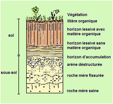
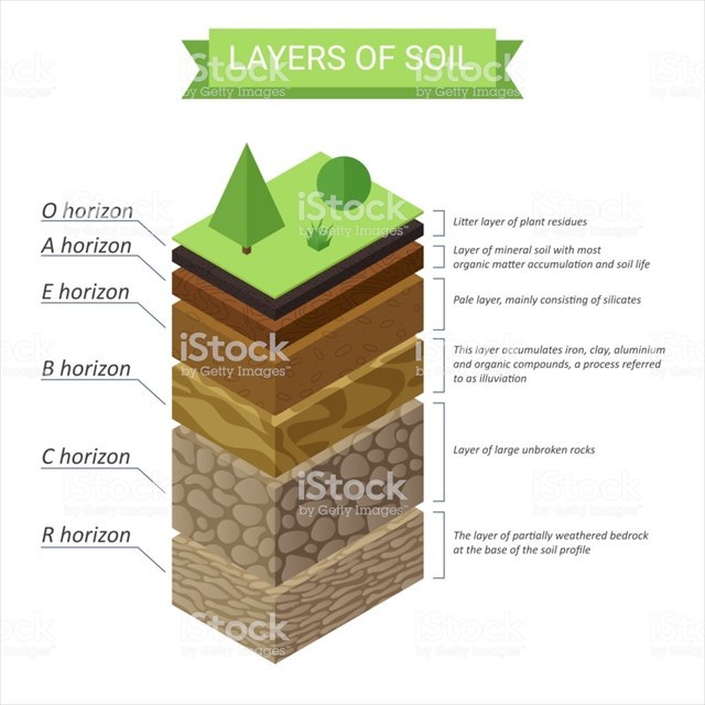
Sol et Sous-sol : Le sol est la partie supérieure de la croûte terrestre et que l’on voit et foule tous les jours. Il recouvre le sous-sol formé de roches. Ce que nous nommons habituellement la terre n’est que la partie superficielle du sol. Mais le sol est plus ou moins épais selon les zones et peut laisser apparaitre directement la roche mère. Généralement meuble, le sol a donc une épaisseur variable. « Il résulte de la transformation de la roche sous-jacente (dite roche-mère) sous l'influence de divers processus, physiques, chimiques et biologiques. Le sol comprend donc une partie minérale et une partie organique : La partie minérale représente l'ensemble des produits de la dégradation physique puis chimique de la roche mère (sables, limons, argiles.. selon la nature de la roche-mère). » La partie organique quant à elle est tout d’abord l’humus, provient de la décomposition des végétaux (feuilles mortes, bois morts…) et des animaux (déjections, cadavres, mues…). Mais à cela s’ajoutent les micros organismes vivants animale et végétale (bactéries, vers, microfaune….).
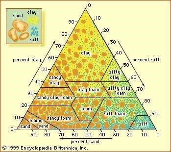
Argileux, limoneux ou sableux ?
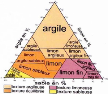
On définit : la texture d'un sol par sa répartition granulométrique de ses constituants. C'est la répartition entre ses petites particules, que sont les argiles, les particules de taille moyenne, les limons, et particules de grande taille et les sables. Les textures sont regroupées en classes : sol argileux, limono-sableux... classé selon le taux de chaque élément, vous trouverez cette répartition dans le tableau ci-dessous. On ne considère que les particules minérales (on exclut la matière organique et les carbonates) et inférieures à 2 mm.
Elle est mesurable en laboratoire grâce à des techniques de sédimentation ou à un granulomètre laser. Mais elle est facilement estimable sur le terrain en suivant la méthode ci-dessous, l’évaluation empirique se fait au doigté lorsque le sol est plastique (humide à frais) :
- Le test du malaxage entre le pouce, l'index et le majeur : appréciation globale grâce à des sensations.
- Les sables (> 0,050 mm, > 50 µm)
- Le toucher est rugueux grossier (pour les sables grossiers) ou fin (pour les sables fins).
- Aucune rugosité entre les doigts : moins de 15 % de sable.
- Forte rugosité, grains de sable visibles à l'oeil nu, effritement rapide de l'échantillon entre les doigts : plus de 50 % de sable.
- Les limons (entre 2 et 50 µm)
- Toucher doux, soyeux, comme du talc.
- Les argiles (inférieures à 2 µm)
- Toucher collant.
- Le test de plasticité ou test du boudin: en roulant de la terre (mouillée au préalable si elle est trop sèche) dans les mains, si on ne peut pas faire un boudin, c'est que le sol est sableux (composé de moins de 10 % d'argile) ; si on peut faire un tube, le sol est limoneux (à peu près 10 % d'argile) ; si on peut faire avec le boudin un anneau qui ne se désagrège pas, c'est que le sol est argileux (composé de plus de 15 à 20 % d'argile).
- Le test de sédimentation (test du bocal) consiste à laisser décanter dans ce récipient de la terre et de l'eau. L'épaisseur de chaque couche formée permet d'estimer le pourcentage de sables/limons/argiles et, en utilisant le triangle des textures, de déterminer le type de sol.
Soil and Subsoil: The ground is the upper part of the Earth’s crust and is seen and crowded every day. It covers the subsoil formed by rocks. What we usually call the earth is only the superficial part of the soil. But the soil is more or less thick depending on the zones and can let the mother rock appear directly. Generally loose, the floor has a variable thickness." It results from the transformation of the underlying rock (so-called mother rock) under the influence of various processes, physical, chemical and biological. The soil therefore consists of a mineral and an organic part: the mineral part represents all the products of the physical and then chemical degradation of the mother rock (sands, silts, clays.. depending on the nature of the mother rock)".The organic part is first of all the humus, comes from the decomposition of plants (dead leaves, dead wood, etc.) and animals (droppings, corpses, molts, etc.). But to this are added the micro-organisms live animal and plant (bacteria, worms, microfauna, etc.).”
Clay, loamy or sandy?
We define: the texture of a soil by its particle size distribution of its constituents. It is the distribution between its small particles, which are clays, medium-sized particles, silts, and large-sized particles and sands. The textures are grouped into classes: clay soil, silty-sandy soil... classified according to the rate of each element, you will find this breakdown in the table below. Only mineral particles (excluding organic matter and carbonates) and less than 2 mm are considered.
It is measurable in the laboratory using sedimentation techniques or a laser particle meter. But it is easily estimable in the field by following the method below, the empirical evaluation is done with fingering when the soil is plastic (wet to cool):
- The test of the mixing between the thumb, the index and the majeur3: global appreciation thanks to sensations.
- Sands (> 0.050 mm, > 50 µm)
- The touch is rough coarse (for coarse sands) or fine (for fine sands).
- No roughness between fingers: less than 15% sand.
- Strong roughness, grains of sand visible to the naked eye, rapid erosion of the sample between the fingers: more than 50% sand.
- Silts (between 2 and 50 µm)
- Soft, silky feel like talc.
- Clays (less than 2 µm)
- Sticky touch.
- The plasticity test or the flange test: by rolling soil (wet beforehand if it is too dry) into the hands, if one cannot make a flange, it is because the soil is sandy (composed of less than 10% clay); if one can make a tube, the soil is silty (about 10 % clay); if it is possible to make with the flange a ring that does not break up, it is because the soil is clay (composed of more than15 to 20 % clay).
- The sedimentation test (jar test) consists of allowing soil and water to settle in this container. The thickness of each layer formed makes it possible to estimate the percentage of sand/silt/clay and, using the triangle of textures, to determine the type of soil.
Pour loguer cette cache / To log this cache :
Pour valider votre visite sur le site, envoyez-moi, en précisant bien le nom de l’earthcache, vos réponses par courrier électronique aux questions suivantes. Vous pouvez loguer "Found it", et je vous contacterai en cas de nécessité:
Questions:
1. Au way point 1 (coordonnée de la earth), quel est la couleur du sol? Et d'après vous pourquoi cette couleur?
2. Avec le test du malaxage décris plus haut que pouvez vous dire sur la nature du sol au WP1? (penser à humidifier le sol avant le test)
3. Avec le test du malaxage décris plus haut que pouvez vous dire sur la nature du sol au WP2? (penser à humidifier le sol avant le test)
4. Les sols aux deux way points sont t'il exactement de même nature? Expliquer ?
To validate your visit to the site, email me, stating clearly the name of the earthcache, your email responses to the following questions. You can log in "Found it," and I will contact you if necessary:
Questions:
1. At waypoint 1 (coordinate of the earth), what is the color of the ground? And why do you think this color?
2. With the mixing test described above about the nature of the soil at WP1? (remember to moisten the floor before the test)
3. With the mixing test described above about the nature of the soil at WP2? (remember to moisten the soil before the test)
4. Are the floors at both ways exactly the same? Explain?
Sources / Sources :
Consultations sur Internet: http://infoterre.brgm.fr/ ; Google Earth ; Geowiki ; Wikipedia; encyclopedia britannica
Rappel concernant les « Earthcaches »: Il n'y a pas de conteneur à rechercher ni de logbook à renseigner. Il suffit de se rendre sur les lieux, de répondre aux questions ci-dessus et de nous renvoyer les réponses via notre profil.
Recall of "Earthcaches" There is no container to seek or logbook to learn. Simply visit the site, answer the above questions and send back responses via our profile.