English? - Scroll down please!
Deutsch? - Bitte nach unten rollen!
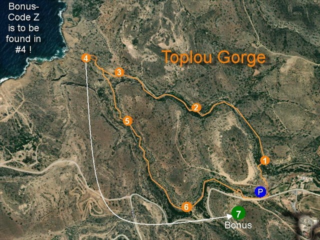
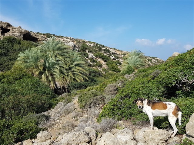
Το μικρό φαράγγι της Τοπλού αποτελεί ένα από τα εντυπωσιακότερα μυστικά της Κρητικής υπαίθρου και ξεκινάει από την τοποθεσία Σώπατα, δίπλα στο ιστορικό μοναστήρι της Παναγίας Ακρωτηριανής Τοπλού. Αποτελείται ουσιαστικά από δύο ξεχωριστές ρεματιές που ενώνονται λίγο πριν φτάσουν στη θάλασσα. Στο μεγαλύτερο το μήκος του δεν εντυπωσιάζει τον επισκέπτη ιδιαίτερα, αλλά κρύβει δύο βασικές εκπλήξεις. Αφενός φιλοξενεί μια πολύ μικρή αποικία Κρητικού Φοίνικα, ενώ στο τέλος του υπάρχουν πηγές με μικρές λίμνες με γλυκό νερό όλο το χρόνο. Οι πηγές αυτές είναι ένα αναπάντεχο γεγονός στην ξηροθερμική ανατολική Κρήτη και μπορούν να προσεγγιστούν με δύο διαφορετικά μονοπάτια που ξεκινούν από τη μονή.
(https://www.cretanbeaches.com/el/)
Η πεζοπορία
(Πηγή: https://www.crete-today.com/toplou-gorge/ Μετάφραση στα Ελληνικά: fio4ever)
Η είσοδος στο φαράγγι είναι 200 μέτρα δυτικά της μονής. Μπορούμε να παρκάρουμε δίπλα στο δρόμο και να δούμε μια αρκετή μεγάλη θύρα μπροστά μας. Περνάμε από αυτή την θύρα, μετά από μια δεξαμενή νερού και κατεβαίνουμε στο κοίτη. Λόγω της πυκνής βλάστησης, παίρνουμε τη συντομότερη διαδρομή προς την άλλη πλευρά του φαραγγιού και έπειτα περπατούμε παράλληλα στη χαράδρα προς τα βόρεια. Μετά από περίπου 200 μέτρα, η βλάστηση μειώνει και τώρα μπορούμε να περπατήσουμε το υπόλοιπο φαράγγι μέσα από το κοίτη.
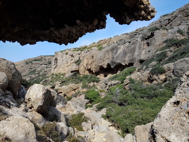
Δεν υπάρχει ορατό μονοπάτι, αλλά η βλάστηση και τα κόκκινα σημεία μας επιτρέπουν να βρούμε τον δρόμο εύκολα. 300 μέτρα πριν από τις λίμνες, το φαράγγι αρχίζει να γίνεται πιο άγονο και πιο βραχώδες και είναι καλύτερο να χρησιμοποιείτε και τα χέρια σε κάποια μέρη. Δεν είναι επικίνδυνο, αλλά σε αυτό το τελευταίο τμήμα της διαδρομής, στο δρόμο προς τις λίμνες, είναι καλό να είσαι εξοικειωμένος με τέτοιες περιστάσεις.
Από την τελευταία λιμνούλα μέχρι τη θάλασσα είναι ακόμα περίπου 100-150 μέτρα. Η κάθοδος δεν φαίνεται ιδιαίτερα ανταμείβοντας, τα πιο θεαματικά περάσματα που έχουμε φτάσει στις λίμνες.
Κατηφορίσαμε εδώ μέσα από την ανατολική φαράγγι, θα επιστρέψουμε στη δυτική φαράγγι. Και πάλι, δεν υπάρχουν ούτε αληθινά μονοπάτια ούτε κόκκινα σημεία. Μένουμε λίγο αριστερά πάνω από το κοίτη του ποταμού (δηλαδή στην ανατολική πλαγιά) και ακολουθούμε τα ίχνη των κατσίκων.
Η βλάστηση σε αυτό το δεύτερο φαράγγι είναι πυκνότερη από την ανατολική και προσέχουμε καλά για να επιλέξουμε τη συντομότερη και πιο ευχάριστη διαδρομή. 500 μέτρα πριν από το τέλος συναντάμε μια μικρή πόρτα, την οποία κλείνουμε όταν περνάμε. Σε αυτό το σημείο βλέπουμε τον πλακόστρωτο δρόμο που συνδέει τη Σητεία με τη Μονή Τοπλού και είμαστε πολύ κοντά στο σημείο εκκίνησης.
Ολόκληρη η διαδρομή έχει μήκος λίγο πάνω από 4 χλμ και απαιτεί κάποια φυσική κατάσταση και εμπειρία λόγω έλλειψης μονοπατιών. Η πεζοπορία θέλει τουλάχιστον τρεις ώρες.
Τα ίχνη μπορείς να κατεβάσεις:
https://www.wikiloc.com/hiking-trails/toplou-gorge-43486893
Οι Κρύπτες
Στο πεζοπορία σας θα βρείτε επτά κρύπτες, έξι τύπου «traditional» και το Μπόνους τύπου «mystery». Στο κουτάκι #4 θα βρείτε τον κώδικα για να υπολογίστε τις συντεταγμένες του Μπόνους.
Καλή διασκέδαση και φέρτε το δικό σας μολύβι!
********** English: **********
One of the most spectacular secrets of Cretan countryside is the small gorge by Toplou Monastery (this is actually a complex of two ravines merging some meters before reaching the sea).
Throughout its short length it hides two key surprises. First, it hosts a small colony of Cretan date palm trees (Theophrastus palm trees), while at the end of it, by the sea, some ponds with fresh water are formed. Especially these springs are an unexpected view in the hot and dry East Crete.
(https://www.cretanbeaches.com/en/)
The Hike
(source: https://www.crete-today.com/toplou-gorge/)
The entrance of the gorge is 200 meters west of the monastery. We can park next to the asphalt road and right in front of us we can see a relatively large door. We go through this door and we pass right next to a water tank and we descend to the bed of the gorge. Due to dense vegetation at that point, we proceed from the eastern side of the bed for about 200 meters. At this point the vegetation is diluted and we can now pass the rest of the gorge all the way through the bed.
There is no visible trail, but marked with red dots and vegetation allows us to find the way easily. 300 meters before we reach the ponds, the gorge begins to get wilder and rocky and in many times we should use our hands as well. It is not dangerous, but some familiarity is needed in that last piece of the route, on the way to the ponds.
From the last pond to the shore is about 100-150 meters. The return is achieved from the western gorge where there is also no path and no signposting. We just go to the eastern side of the gorge, just above the riverbed. The vegetation in this second gorge is denser than the eastern one and we are proceeding carefully trying to choose the shortest and cleanest route. 500 meters before the end we will meet a small door, which we close as we pass it. At this point we can see the asphalt road that connects Sitia with the Toplou monastery and we are very close to the starting point now. The total route is a little more than 4 kms and requires a basic familiarity and fitness due to the absence of a path. The hike will take you at least three hours.
You may download the trail:
https://www.wikiloc.com/hiking-trails/toplou-gorge-43486893
The Geocaches
You will find seven geocaches on this circular walk, six of them traditionels and the Bonus (mystery). In the container of #4 you will find the code which will be necessary to calculate the coordinates of the Bonus.
Enjoy and bring your own pen!
********** Deutsch: **********
Eines der spektakulärsten Phänomene der kretischen Landschaft ist die kleine Schlucht bei dem Kloster Toplou (das ist eigentlich ein Komplex von zwei Schluchten, die einige Meter vor dem Erreichen des Meeres verschmelzen).
Während ihrer kurzen Länge verbirgt sie zwei schöne Überraschungen. Zuerst beherbergt sie eine kleine Kolonie der kretischen Dattelpalmen (Theophrastus Palmen) und später, kurz vor Erreichen des Meeres finden sich einige Teiche mit frischem Wasser. Besonders diese Quellen sind ein unerwarteter Anblick in dem heißen und trockenen Ostkreta.
(https://www.cretanbeaches.com/de/)
Die Wanderung
(Quelle: https://www.crete-today.com/toplou-gorge/ translated to German: fio4ever)
Der Eingang der Schlucht liegt 200 Meter westlich des Klosters. Wir können neben der Asphaltstraße parken und sehen unmittelbar vor uns ein relativ grosses Tor. Wir gehen durch dieses Tor, danach an einem Wassertank vorbei und steigen zum Bett der Schlucht hinunter. Aufgrund der dichten Vegetation gehen wir an dieser Stelle auf dem kürzesten Weg auf die andere Seite der Schlucht und danach etwas oberhalb der Schlucht parallel zum Bachbett nach Norden. Nach etwa 200 Metern wird die Vegetation luftiger und wir können jetzt den Rest der Schlucht durch das Bett laufen.
Es gibt keinen sichtbaren Pfad, aber die Vegetation und rote Punkte ermöglichen es uns, den Weg leicht zu finden. 300 Meter vor den Teichen beginnt die Schlucht wilder und felsiger zu werden und hie und da ist es wohl besser, auch die Hände zu benutzen. Es ist nicht gefährlich, aber auf diesem letzten Stück der Route, auf dem Weg zu den Teichen, ist es gut, wenn man mit derartigem Gelände vertraut ist.
Vom letzten Teich bis zum Meer sind es noch ca. 100-150 Meter. Der Abstieg scheint nicht besonders lohnend, die spektakulärsten Passagen haben wir bei den Teichen oder Gumpen erreicht.
Durch die östliche Schlucht sind wir hierher abgestiegen, die Rückkehr erfolgt durch die westliche Schlucht. Auch hier gibt es keinen Weg und auch keine roten Punkte. Wir halten uns ein wenig links oberhalb des Flussbetts (also am östlichen Hang) und folgen den Ziegenpfaden.
Die Vegetation in dieser zweiten Schlucht ist dichter als in der östlichen und wir halten sorgfältig Ausschau, um die kürzeste und angenehmste Route zu wählen. 500 Meter vor dem Ende treffen wir auf eine kleine Tür, die wir beim Passieren schließen. An dieser Stelle sehen wir die asphaltierte Straße, die Sitia mit dem Kloster Toplou verbindet und wir sind jetzt sehr nah am Startpunkt.
Die gesamte Strecke ist etwas mehr als 4 km lang und erfordert aufgrund des Fehlens eines Pfades etwas Kondition und Erfahrung. Gut drei Stunden solltet Ihr für diese Wanderung einplanen.
Den Track findet Ihr zum Herunterladen hier:
https://www.wikiloc.com/hiking-trails/toplou-gorge-43486893
Die Geocaches
Auf dieser Rundwanderung könnt Ihr sieben Dosen finden, sechs Tradis und eine Bonus-Dose. In der Dose #4 findet Ihr den Code, der Euch zu den Koordinaten des Bonus führt.
Viel Spass und bringt einen Stift mit!