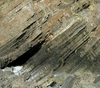
As you descend the steps into the cove from the given coordinates you can't really miss the impressive curves and folds in the layers of rock of the cliff. To give a brief summary, sedimentary rocks form in flat layers as sediments are deposited and eventually compacted into layers of rock. If these rocks become bent or folded it is due to movement of plates in the Earth’s crust pushing against one another and physically bending the rock into the shapes you see in front of you here.
This EarthCache brings you to see one of the most impressive but accessible examples of rock folding on the Isle of Man, and the information below explains in a little more detail what you see before you and why it occured. To log a find, you simply need to answer a few questions below and remember, you are not expected to have any previous geological knowledge, everything you need is in the information provided here.
Sedimentary rocks are in front of you...
When you arrive here you will see the rock is in very well defined layers and this is a good indication that the rock is sedimentary. Sedimentary rocks can be formed from particles of sand, shells, pebbles, and other fragments of material. Together, all these particles are called sediment. Gradually, the sediment accumulates in layers and over a long period of time hardens into rock. An example might be millions of years ago a flood caused a layer of sand to be deposited. This might create one layer of the rock you see here. Then maybe a few years or many years later another flood left another layer of sand. Again, another layer is created. This process continued for millions of years, the lower layers gradually getting squeezed more and more by the heavy deposits above them. The thickness of the layer is determined by the amount of sediment deposited, therefore a bigger and longer flood would deposit more sediment creating a thicker layer.
As you can probably imagine, if these rocks were formed by sediment left by water, the rocks when formed would have been flat - or horizontal on the ground. Any rocks you see here that are not flat or horizontal on the ground have been moved later by geological processes and how this has happened is explained below. Each layer is formed at a different time and from a different 'batch' of sediment. This means some layers may be strong whilst some are more weak and therefore more susceptible to various forces many years later.
Why are the rocks here no longer straight or flat?
EarthCaches about folded rocks can be tricky to understand but don't be reaching for your paracetamol just yet as I'm going to try and make this as clear as the water splashing about in the sea nearby (which looks lovely by the way). Firstly, imagine that the ground you walk on, also known geologically as the Earth's outer shell, is divided into several plates that glide over the mantle (the mantle is the rocky inner layer above the Earth's core).

Now, imagine that those plates once created super continents - and then imagine that those two plates/super continents collided. There's no great speeds involved, the movement is extremely slow but imagine the weight and force they would have. Now that you have got the image of these two plates colliding in your mind, picture this bit of rock in front of you being right in the middle. It's similar to a car crash when all the metal bends and gets compressed - the same happened here to our sedimentary rock.
Looking at Folds in more detail
The geology of folds is very complex, many EarthCaches look at anticlines and synclines but here only one section of fold is visible due to the geology and lay of the land. Therefore, to keep it understandable here we are only going to consider the types of fold that have may have occurred here. The diagram below will help to explain the main types of fold that can occur.

- If the two limbs of the fold dip away from the axis with the same angle, the fold is said to be a symmetrical fold.
- If the limbs dip at different angles, the folds are said to be asymmetrical folds.
- If the compressional stresses that cause the folding are intense, the fold can close up and have limbs that are parallel to each other. Such a fold is called an isoclinal fold (iso means same, and cline means angle, so isoclinal means the limbs have the same angle). Note the isoclinal fold depicted in the diagram above is also a symmetrical fold.
- If the folding is so intense that the strata on one limb of the fold becomes nearly upside down, the fold is called an overturned fold.
- An overturned fold with an axial plane that is nearly horizontal is called a recumbant fold.
- A fold that has no curvature in its hinge and straight-sided limbs that form a zigzag pattern is called a chevron fold.
Logging Requirements (Questions to Answer)
The given coordinates bring you to a viewpoint on the higher part of a zig-zag path leading down to the cove. Beneath you the path should be zagging back below you and above the path you will see a dramatic section of cliff where the layers are anything but flat. Use the information provided in the listing along with your own observations to guide you to the answers. Please ensure you send in the answers soon after you log your find, as logs may be deleted if no attempt at the answers are made - a reasonable attempt is all that is required.
Q1 - Look at the exposed cliff and focus your attention on the right hand side of the cliff where there is a very large visible curve in the rock layers. Make the following observations:
a) At one point the rock layers are vertical. Is this at the top or the bottom of the visible curve?
b) At one point the rock layers are almost horizontal. Is this at the top of bottom of the visible curve?
c) Does the rock curve towards the sea or inland?
d) Estimate the angle on the outer edge of the curve.
e) Estimate the angle of on the inner edge of the curve.
Q2 - Now focus your attention on the left side of the cliff where the rock layers become more folded rather than curved. Make the following observations:
a) Does the fold face the sea or inland?
b) Is this fold going in the same direction as the curve you described in question 1?
c) What is the angle in the centre of the fold?
d) Are the layers in the fold thicker or thinner than those in the curve?
Q3 - Using the observations you have made above and the information/illustration in the listing, please identify the type of fold in front of you here. Remember, part of the fold has eroded to the sea and part of the fold continues beneath the steps. Pay particular attention to the angles you have estimated. Because only part of the fold is visible, this makes the question more difficult so please don't worry if you are not completely certain. Please feel free to include a justification as to how you came to your conclusion.
Finally, please include a photograph of yourself with the bay as additional proof you were there. Under revised guidelines this is now a logging requirement, however, please do not include photographs of the curve/fold with your log.
Thank you for visiting the Douglas Head EarthCache