
Le contexte
Juste avant d’arriver dans le vallon du Clou, une cavité taillée par l’Homme (un déversoir du barrage inachevé un peu plus en amont) offre l’occasion d’observer la rencontre entre deux roches à l’aspect semblable mais si différentes !
Les roches du Vallon
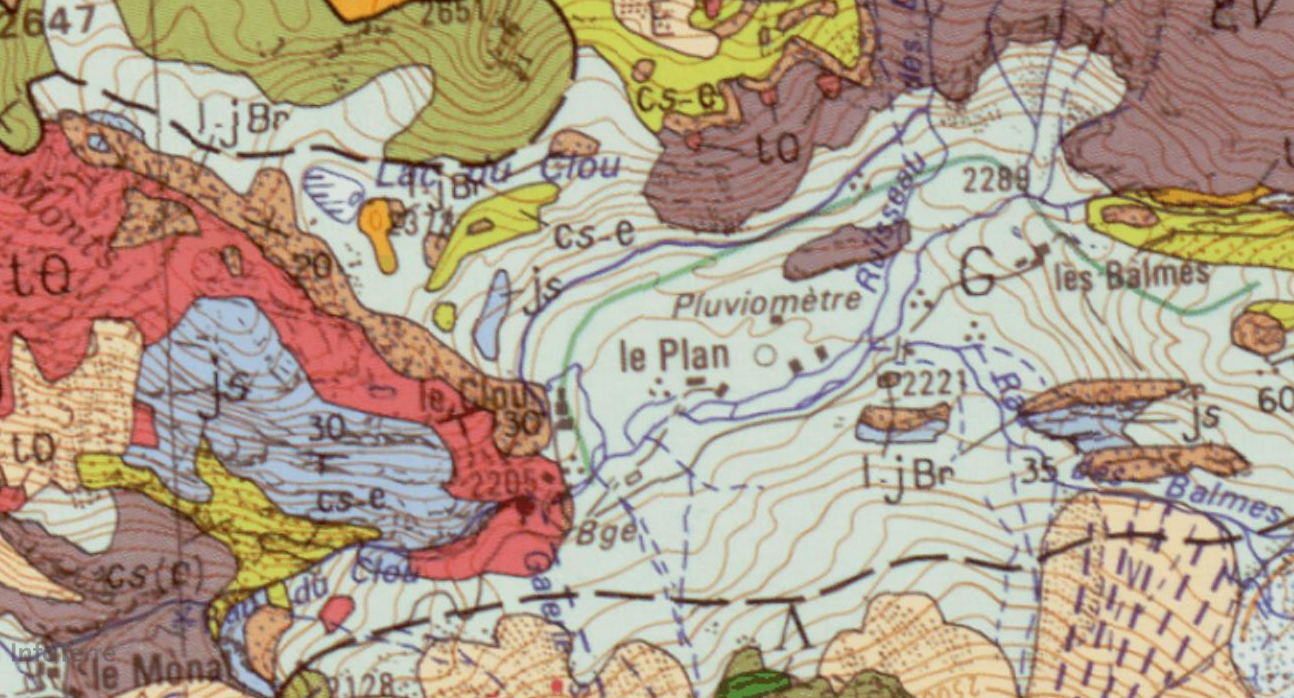
Si les hauts sommets encadrants le vallon du Clou sont constitués de roches cristallines anciennes (micaschistes anté-Permien, -300 Ma environ, en gris-bordeaux sur la carte), vestiges de la grande chaîne hercynienne (chaîne varisque), dans le bas du vallon affleurent deux roches métamorphiques très différentes et pourtant très ressemblantes :
- le marbre blanc (js sur la carte géologique, en bleu) : c’est une roche carbonatée, issue du métamorphisme d’une roche calcaire. Elle est claire et plutôt hétérogène : parfois à passées bréchiques, elle devient même localement de véritables brèches polygéniques à ciment calcaire gris, à grain fin. Par places, on peut aussi retrouver de véritables bancs de grès calcareux blancs. La roche s’est formée lors du Jurassique Supérieur (ou Malm, de -161 Ma à -146 Ma) au moment de l’extension maximale de l’Océan Alpin. Elle affleure ici sous forme de roche litée, gris blanc jaunâtre, se débitant aisément en plaques et plaquettes en raison de sa sensibilité à la gélifraction (cryoclastie).
- le quartzite blanc (tQ sur la carte, en rouge) : c’est une roche siliceuse, issue du métamorphisme d’une roche sédimentaire riche en quartz (le grès, par exemple). La roche s’est formée lors du Trias inférieur (de -252 Ma à -247 Ma), soit avant le recouvrement de la zone par l’Océan Alpin. Elle affleure ici sous forme d’une roche globalement blanche, massive et homogène. Son aspect est assez proche de celui du marbre en raison de l’alternance de strates plus sombres, mais son débit est fort différent : sa cassure est conchoïdale (cassure franche, courbe et lisse).
Les plis
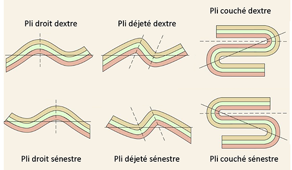
Un pli est une déformation des roches sous l'effet des contraintes. La roche, sous l'effet des forces tectoniques, n'a pas cassé mais plié. Ce comportement "plastique" peut être celui de roches très rigides, d'habitude cassantes. En effet, l'application sur une longue période de forces de faible intensité permet une modification graduelle de la roche (son plissement) au lieu de sa fracturation. On distingue plusieurs types de plis (voir schéma) selon la géométrie, dont :
- les plis droits : les deux flancs du pli ont le même pendage mais de sens opposé, il existe un plan axial de symétrie ;
- les plis déjetés : on trouve un plan axial légèrement incliné de tel manière que les deux flans ont un pendage différent ;
- les plis couchés : le plan axial est presque horizontal, et les flancs sont horizontaux et se recouvrent.
Selon le « sens » du pli, on peut également distinguer les plis sénestres des plis dextres. Pour les reconnaître, c’est simple : le pli sénestre dessine la lettre S, et le pli dextre est son image dans un miroir (voir schéma) :
Bibliographie / sitographie
Carte géologique de la France imprimée 1/50000, Feuille Ste-Foy-Tarentaise, BRGM
www.geowiki.fr
https://ft.univ-tlemcen.dz/assets/uploads/pdf/departement/gc/houti/Chapitre-4-NOTION-SUR-LA-TECTONIQUE.pdf
https://docplayer.fr/8422905-Les-plis-partie-1-geometrie-et-representation-stereographique.html
Questions
La lecture attentive du descriptif de la cache, ainsi qu'une observation des éléments de terrain et un peu de déduction sont normalement suffisants pour répondre aux questions de cette EarthCache.
Aux coordonnées du listing, face à l’ouverture de la cavité, et repérez les zones verte et rouge (photo « Zones Clou »). Approchez de chacune d’elle, observez les roches et répondez aux questions suivantes :
1. Sans étudier le descriptif, diriez-vous que le marbre est à droite ou à gauche de l’entrée ?
2. Décrire la roche à gauche de l’entrée (zone verte) : la roche est-elle plutôt homogène ou hétérogène sur l’ensemble de la zone ? A-t-elle tendance à « s’effriter » et former des plaquettes ? Voyez-vous des strates sombres zébrer la roche ?
3. Décrire la roche à droite de l’entrée (zone rouge) : la roche est-elle plutôt homogène ou hétérogène sur l’ensemble de la zone ? A-t-elle tendance à « s’effriter » et former des plaquettes ? Voyez-vous des strates sombres zébrer la roche ?
4. En vous aidant du descriptif et des réponses précédentes, en déduire la nature des roches (marbre blanc / quartzite blanc) de chacune des zones (verte / rouge).
5. Votre hypothèse à la question 1 était-elle la bonne ? Si non, dire ce qui vous a induit en erreur.
À droite de l’entrée, repérez la petite zone jaune au sein de la zone rouge (petit carré fléché de la photo « Zone jaune »). Approchez-vous en, vous devriez voir les effets des contraintes tectoniques énormes subies par les roches tout au long de l’orogénèse des Alpes. Observez de près, et répondez aux questions suivantes :
6. Parmi les deux motifs proposés, lequel pouvez-vous voir sous le carré jaune : le motif A ou le motif B ?
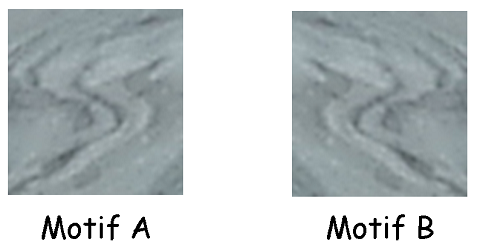
7. En déduire le type de pli observable ici (droit, déjeté ou couché) et son orientation (dextre ou sénestre) ?
Optionnel : une photo de vous ou votre GPS sur place n’est pas obligatoire mais fortement appréciée ^^
Vous pouvez vous loguer sans attendre notre confirmation, mais
vous devez nous envoyer les réponses en même temps soit par mail via notre profil, soit via la messagerie geocaching.com (Message Center). S'il y a des problèmes avec vos réponses nous vous en ferons part.
Les logs enregistrés sans réponses seront supprimés.

The context
In the heart of the Grandes Alpes, come and discover the geological richness of a hike without any particular difficulty (about 10 km for 650m of positive altitude difference), with a sublime viewpoint on Mont-Blanc at the Col de la Seigne!
Clou valley rocks
If the high peaks surrounding the Clou valley are made up of ancient crystalline rocks (anterior Permian micaschists, about -300 Ma, in coral grey on the map), remains of the great Hercynian chain (Variscan chain), at the bottom of the valley outcrop two very different and yet very similar metamorphic rocks:
- white marble (js on the geological map, in blue): it is a carbonated rock, resulting from the metamorphism of a limestone rock. It is clear and rather heterogeneous: sometimes with brecciated past, it even becomes locally real polygenic breccias with grey, fine-grained limestone cement. In places, you can also find real banks of white calcareous sandstone. The rock was formed during the Upper Jurassic (or Malm, from -161 Ma to -146 Ma) at the time of the maximum extension of the Alpine Ocean. It outcrops here in the form of bedded rock, yellowish white grey, flowing easily into plates and platelets because of its sensitivity to gel fraction (cryoclasty).
- white quartzite (tQ on the map, in red): it is a siliceous rock, resulting from the metamorphism of a sedimentary rock rich in quartz (sandstone, for example). The rock was formed during the Lower Triassic Period (-252 Ma to -247 Ma), before the area was covered by the Alpine Ocean. It outcrops here in the form of a generally white, massive and homogeneous rock. Its appearance is quite similar to that of marble due to the alternation of darker strata, but its flow rate is very different: its break is conchoidal (straight, curved and smooth break).
Folds
A fold is a deformation of rocks under the effect of stress. The rock, under the influence of tectonic forces, did not break but bent. This "plastic" behaviour can be that of very rigid, usually brittle rocks. Indeed, the application of low intensity forces over a long period of time allows a gradual modification of the rock (its folding) instead of its fracturing. There are several types of folds (see diagram) depending on the geometry, including:
- straight folds: the two sides of the fold have the same dip but in opposite directions, there is an axial plane of symmetry ;
- depressed folds: there is a slightly inclined axial plane so that the two blanks have a different dip;
- lying folds: the axial plane is almost horizontal, and the flanks are horizontal and overlapping.
Depending on the "direction" of the fold, we can also distinguish between senestral folds and dextral folds. To recognize them, it's simple: the senestral fold draws the letter S, and the dextral fold is its image in a mirror (see diagram):
Questions
The careful reading of the cache description, as well as an observation of the field elements and a little deduction are normally sufficient to answer the questions of this EarthCache.
At listing coordinates, facing the opening of the cavity, and locate the green and red areas ("Zones Clou" picture). Approach each one, observe the rocks and answer the following questions:
1. Without studying the listing, would you say that the marble is to the right or left of the entrance?
2. Describe the rock to the left of the entrance (green area): is the rock rather homogeneous or heterogeneous over the entire area? Does it have a tendency to "crumble" and form platelets? Do you see dark layers zebraing the rock?
3. Describe the rock to the right of the entrance (red zone): is the rock rather homogeneous or heterogeneous over the entire area? Does it have a tendency to "crumble" and form platelets? Do you see dark layers zebraing the rock?
4. Using the description and the previous answers, deduce the nature of the rocks (white marble / white quartzite) in each of the areas (green / red).
5. Was your hypothesis in question 1 correct? If not, say what misled you.
To the right of the entrance, locate the small yellow area within the red area (small square marked with arrows in the "Zone jaune" picture). Approach it, you should see the effects of the enormous tectonic stresses experienced by rocks throughout the orogeny of the Alps. Observe closely, and answer the following questions :
6. Which of the two patterns offered can you see under the yellow square: pattern A or pattern B?
7. Determine the fold type (straight, depressed or lying) and its orientation (dextral or senestral)?
Optionnal: a picture of you or your GPS on site is not mandatory but highly appreciated ^^
You can log in without waiting for our confirmation, but
you must send us the answers at the same time either by email via our profile or via geocaching.com (Message Center). If there are any problems with your answers we will let you know.
Logs recorded without answers will be deleted .