
Le contexte
Tout près du très joli village d’Aussois, venez découvrir ce site qui mêle découverte archéologique et géologique !
L’histoire géologique du site
Étape 1 :
Après des dérives tectoniques, la mer peut envahir la région. C’est la formation de l’Océan Alpin, dont le plancher est constitué de ce qui subsiste de la chaîne hercynienne (chaîne varisque), une gigantesque chaîne de montagnes presque entièrement érodée. Au fil des millénaires, la roche calcaire naît par sédimentation au fond des océans puis va subir un certain nombre de transformations avant de devenir un marbre poli par le glacier.

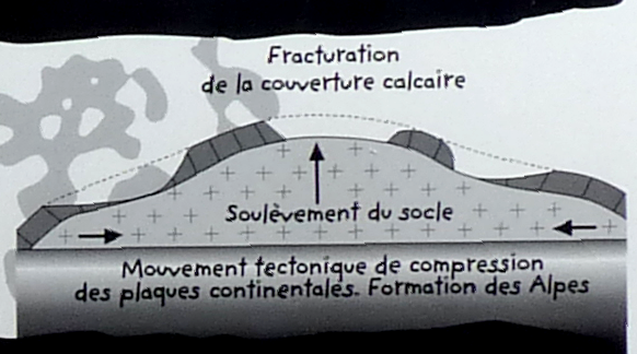
Étape 2 :
La plaque africaine pivote, provoquant un rapprochement avec la plaque européenne. C’est le grand carambolage, l’Océan Alpin se ferme et les Alpes se soulèvent. La couverture calcaire se fracture en lambeaux.
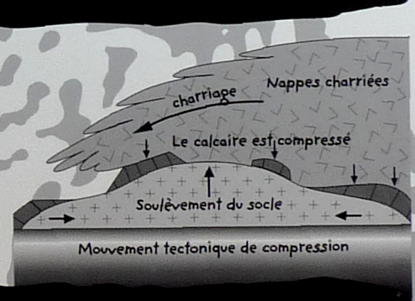
Étape 3 :
Des nappes de terrain, charriées par les mouvements tectoniques des plaques, recouvrent le calcaire. Écrasé par leur poids, il se transforme en marbre dur : c’est le métamorphisme.
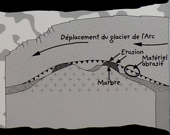
Étape 4 :
Bien plus tard, lors d’épisodes de températures beaucoup plus basses à l’échelle mondiale, d’immenses glaciers recouvrent les latitudes les plus hautes ainsi que les chaînes de montagnes. Le glacier de l’Arc, épais de plusieurs centaines de mètres au moment de son étendue maximale, « s’écoule » et se charge de fragments des roches tendres. À la différence de celles-ci, le marbre résiste au passage du glacier mais celui-ci est chargé de matériel abrasif à sa base. Les fragments griffent le marbre, et les sables le polissent.
Étape 5 :
Après la dernière grande glaciation du Würm, la décrue du glacier laisse apparaître le travail d’érosion et de polissage du marbre.
Bibliographie / sitographie
Panneaux d’information sur site (Parc National de la Vanoise)
Questions
La lecture attentive du descriptif de la cache, ainsi qu'une observation des éléments de terrain et un peu de déduction sont normalement suffisants pour répondre aux questions de cette EarthCache.
Aux coordonnées indiquées, vous trouverez 3 panneaux, dont 2 vous aideront à répondre aux questions suivantes :
1. D’après la chronologie indiquée sur le panneau, depuis combien de temps est-il possible pour l’Homme de laisser, comme le glacier avant lui, une trace sur ce marbre à l’histoire mouvementée ?
2. À quelle ère géologique et à quelle date est reliée la formation de la roche calcaire ?
3. Entre le début de la formation du calcaire au fond de l’Océan Alpin et le polissage du marbre qui en résulte par le glacier, combien d’années se sont écoulées ?
4. Quelle était l’épaisseur du glacier de l’Arc lors de son travail de polissage du marbre ?
5. Pourquoi pourrait-on affirmer que sans le métamorphisme, nous n’aurions vraisemblablement jamais pu admirer ces gravures préhistoriques ?
Optionnel : une photo de vous ou votre GPS sur place n’est pas obligatoire mais fortement appréciée ^^
Vous pouvez vous loguer sans attendre notre confirmation, mais
vous devez nous envoyer les réponses en même temps soit par mail via notre profil, soit via la messagerie geocaching.com (Message Center). S'il y a des problèmes avec vos réponses nous vous en ferons part.
Les logs enregistrés sans réponses seront supprimés.

The context
Very close to the very pretty village of Aussois, come and discover this site which combines archaeological and geological discovery!
Site geological history
Stage 1 :
After tectonic drifts, the sea can invade the region. It is the formation of the Alpine Ocean, whose floor is made up of the remaining part of the Hercynian chain (Variscan chain), a gigantic mountain chain almost entirely eroded. Over the millennia, limestone rock is formed by sedimentation on the ocean floor and then undergoes a number of transformations before becoming a marble polished by the glacier.
Stage 2 :
The African plate rotates, bringing it closer to the European plate. It's the big pile-up, the Alpine Ocean closes and the Alps rise. The limestone cover fractures into shreds.
Stage 3 :
Groundwater, carried by the tectonic movements of the plates, covers the limestone. Crushed by their weight, it turns into hard marble: it is the metamorphism.
Stage 4 :
Much later, during episodes of much lower global temperatures, huge glaciers cover the highest latitudes and mountain ranges. The Arc glacier, several hundred metres thick at its maximum extent, "flows" and is loaded with fragments of soft rocks. Unlike these, marble resists the passage of the glacier, but the glacier is loaded with abrasive material at its base. The fragments scratch the marble, and the sands polish it.
Stage 5 :
After the last great glaciation of the Würm, the retreat of the glacier reveals the work of erosion and polishing of the marble.
Bibliography / sitography
On-site information panels (Vanoise National Park)
Questions
Careful reading of the cache description, as well as an observation of the field elements and a little deduction are normally sufficient to answer the questions of this EarthCache.
At the coordinates indicated, you will find 3 panels, 2 of which will help you answer the following questions:
1. According to the chronology indicated on the panel, how long has it been possible for Man to leave, like the glacier before him, a trace on this marble with its turbulent history?
2. To which geological era and date is the formation of limestone related?
3. How many years have passed between the beginning of the formation of limestone at the bottom of the Alpine Ocean and the resulting polishing of the marble by the glacier?
4. What was the thickness of the Arc glacier when it polished the marble?
5. Why could we say that without metamorphism, we would probably never have been able to admire these prehistoric engravings?
Optional: a picture of you or your GPS on site is not mandatory but highly appreciated ^^
You can log in without waiting for our confirmation, but
you must send us the answers at the same time either by email via our profile or via geocaching.com (Message Center). If there are any problems with your answers we will let you know.
Logs recorded without answers will be deleted.