East Meets West - Wrangel Island EarthCache
East Meets West - Wrangel Island
-
Difficulty:
-

-
Terrain:
-

Size:  (other)
Please note Use of geocaching.com services is subject to the terms and conditions
in our disclaimer.
Congratulations! You have reached one of the most isolated places in the world, Wrangel Island. It is estimated that only 500 people will visit Wrangel Island in 2019 though it appears that number will grow to 2500 by the following year. To put that in perspective, 50,000 people visit Antarctica each year. You're here for the polar bears and you're here to visit this amazing, isolated corner of the world.
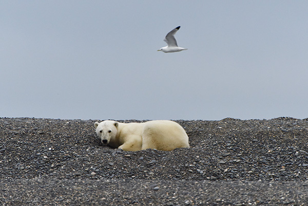
The Birds and the Bears
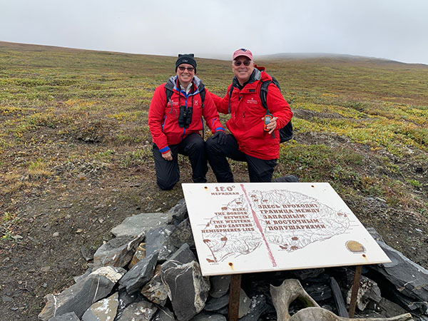
RetiredGirl and RetiredGuy straddling the two hemispheres
East Meets West Timeline on Wrangel Island
Wrangel Island is where East and West have met in significant ways over time. This Earthcache explores three of those times: 1884, 9000 BC, and 215 million BC. And today you will have your own chance to log your East meets West moment.

East Meets West – 1884: Delegates from 25 countries met in Washington, DC, at the International Meridian Conference and choose the prime meridian to be based at the Royal Observatory, Greenwich, England. With the latitude of Greenwich, England set at 0°, Wrangel Island became crossed by the 180° latitudinal line. While the International Date Line usually follows the 180° latitudinal line, it was moved east such that all of Russia, including Wrangel Island would be in the same day. So, if you stand behind the demarcation sign, your right foot will be in the Eastern Hemisphere and your left foot will be in the Western Hemisphere.
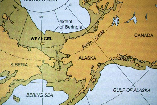
East Meets West – Prior to 9000 BC – Beringia: Global cooling during the period beginning 70,000 BC caused the expansion of polar ice and thus the lowering of sea level. The Bering Sea separating Alaska and Russia is quite shallow with typical depths between 100 and 150 feet. During this period of global cooling, sea level fell significantly creating a "land bridge" between the present day Russia and Alaska. While "bridge" may imply a narrow strip of land, the overall size of this land was tremendous and is referred to as Beringia. The connection between the two continents allowed for the movement of vast numbers of animal species including humans. By 11,000 BC the sea had risen again, cutting off the two continents and forming Wrangel Island out of a mountain range. Wrangel Island would remain isolated from there, including being home to the last surviving woolly mammoths who went extinct roughly 2,000 BC, hundreds of years after the Egyptians built the pyramids.
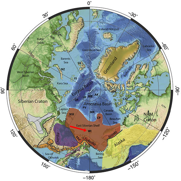
East Meets West – 215 million BC – East Siberian Shelf: Stanford researcher Elizabeth Miller and others have examined and found similar geological evidence on Wrangel Island as has been found on the Brooks Range in Alaska and Chukotka in Russia. This evidence indicates that it is likely that Wrangel Island was part of the Brooks Range of northern Alaska which then extended into Arctic Russia. In Geology of Wrangel Island, Arctic Russia, Revisited, Miller wrote "Comparison of single grain U-Pb ages of detrital zircons from the Triassic of Wrangel to the Russian Arctic mainland and to the Lisburne Hills, Alaska, suggests basin continuity and similar source regions between these three regions (but not the N. Slope) in the Triassic. Single grain ages as young as 215 Ma [million BC] validate the inferred Triassic age of these sediments on Wrangel Island."
When zircon (ZrSiO4) is formed, it will contain uranium in its crystal structure but no lead. Uranium will decay into lead at a precise rate which is known as its half-life, i.e. the time it takes for half of the uranium to decay into lead. Specifically the half-life of the uranium-235 isotope, which decays to lead-207, is 710 million years meaning that after 710 million years, zircon would have equal amounts of uranium-235 and lead-207.
Requirements for this Earthcache:
A. Send the cache owner the answers to the following questions (do not post answers in log):
1) While standing at the demarcation sign, use your GPS to determine how far you are from the Earthcache (GC7V56P) in Greenwich, England.
2) Do a little internet research. Why do you think the woolly mammoths on Wrangel Island went extinct?
3) For the zircon found on Wrangel Island, did it have more uranium-235 or lead-207 in it? Please explain how you reached you conclusion.
B. Logging your find: Post a picture of the demarcation sign in your log. If you are not in the picture, please include in the picture, a piece of paper with your caching name written on it. In addition to the picture, please list the name of your ship and the name of your captain.
You may immediately log this cache after your visit but your log will be deleted if you do not include the picture or if you do not send answers to the questions. You must visit the island to claim a find.
Additional Hints
(No hints available.)